|
|
 |
|

|
|
|
Application of ZY-1 02D hyperspectral data to altered mineral mapping and ore prospecting in desert areas along the northern margin of the Qaidam Basin |
QI Changwei1( ), DONG Ji’en1,2(), CHENG Xu3, YE Gaofeng2, HE Shuyue4, DAI Wei4, WANG Bing3 ), DONG Ji’en1,2(), CHENG Xu3, YE Gaofeng2, HE Shuyue4, DAI Wei4, WANG Bing3 |
1. Geological Survey of Qinghai Province, MNR Technology Innovation Center for Exploration and Exploitation of Strategic Mineral Resources in Plateau Desert Region, Xining 810000, China
2. School of Geophysics and Information Technology, China University of Geosciences(Beijing), Beijing 100083, China
3. Airborne Survey and Remote Sensing Center of Nuclear Industry, Shijiazhuang 050002, China
4. No.3 Exploration Institute of Geology Resources of Qinghai Province, Xining 810008, China |
|
|
|
|
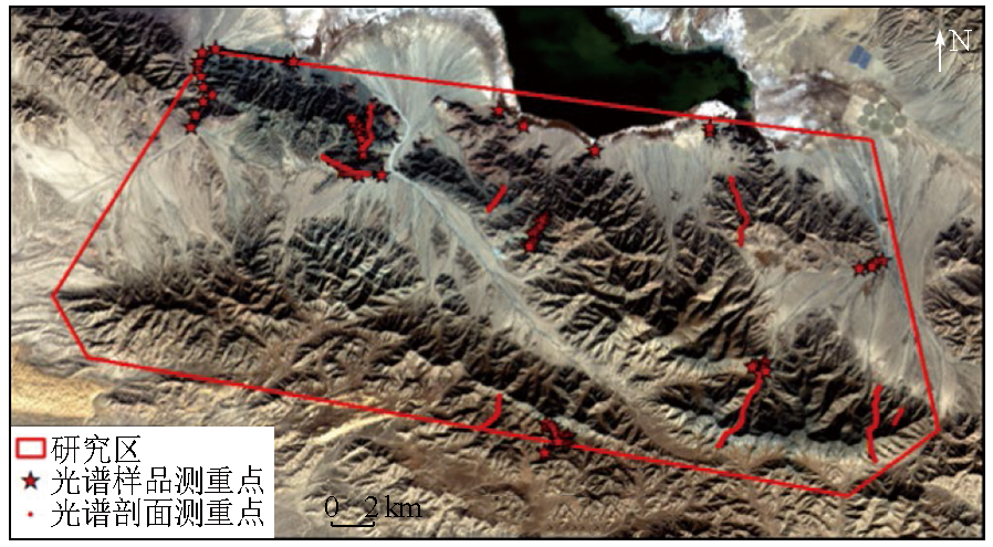
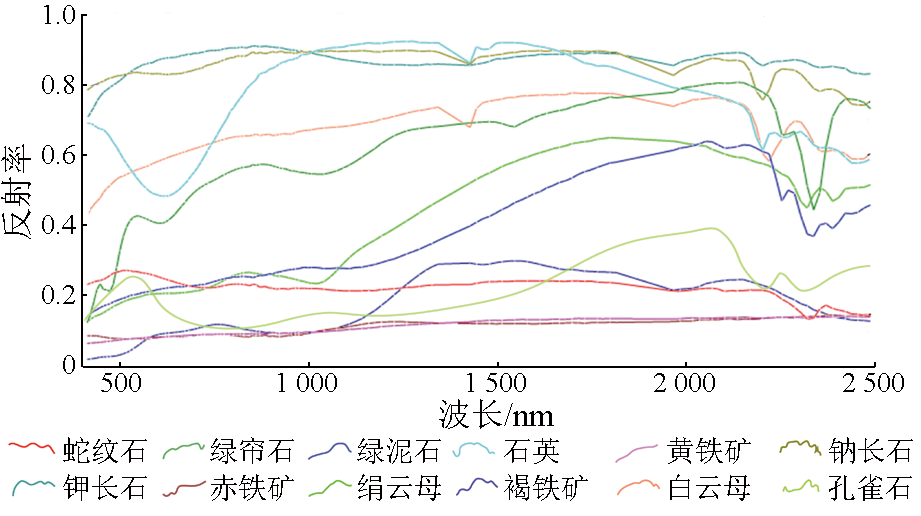
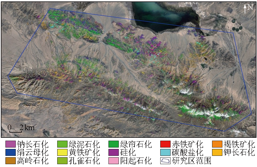
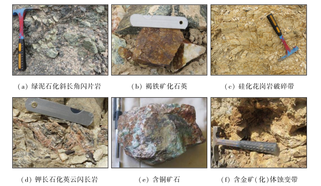
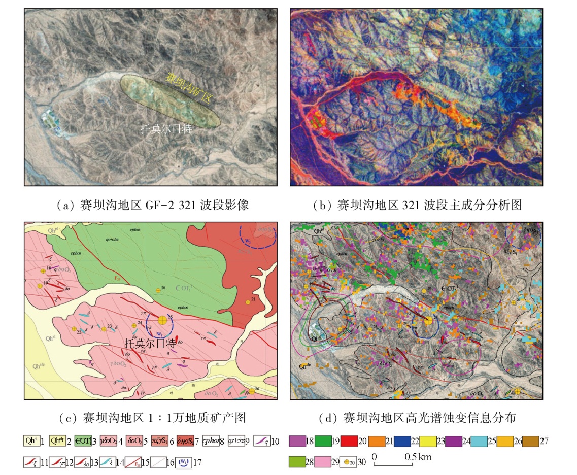
Abstract The geological exploration in Qinghai Province is conducted in typical highland desert areas characterized by significant terrain cutting, low vegetation cover, extensive bedrock outcrops, and challenging surface investigations. To investigate the application of hyperspectral data from a satellite in altered mineral mapping and ore prospecting in desert areas along the northern margin of the Qaidam Basin, this study utilized hyperspectral remote sensing images with high spatial and spectral resolutions obtained from the domestic ZY1-02D satellite. Following fine-scale radiometric calibration, atmospheric correction, data restoration, and orthorectification, high-quality hyperspectral remote sensing images were acquired for desert areas, such as Saibagou, along the northern margin of the Qinghai Province. After comprehensive field survey sampling and spectral testing using a FieldSpec Pro FR spectrometer, a standard laboratory spectral dataset of the surveyed areas was established, containing 13 major altered minerals such as chlorite. Finally, the extraction of altered minerals and ore prospecting were conducted. The results indicate that the primary altered minerals in the areas include 13 types: epidote, chlorite, albite, sericite, silicification, kaolinite, carbonate, limonite, actinolite, serpentine, hematite, pyrite, and malachite. The distribution of these altered minerals is closely associated with the strata, lithology of intrusions, and ductile shear structures. The analysis of the alteration characteristics of typical mineral deposits such as Saibagou reveals that malachitization, limonitization, pyritization, sericitization, and silicification are closely related to mineralization, being indicative of ore prospecting. Partial potassium feldspathization, chloritization, epidotization, and sodium feldspathization are also somewhat related to mineralization, serving as a valuable reference for ore prospecting. As a result of applying the above methods, combined with the 1:25 000 geochemical survey data, one copper-gold mineralized point was discovered in the Tuomoerrite area. Therefore, hyperspectral data-based alteration mineral mapping compensates for the limitations of traditional geological surveys and ore prospecting methods in the western desert areas of China with harsh natural conditions. This allows for rapid assessment of the regional geological setting and mineralization conditions, enabling the extraction of mineral spectral information. The hyperspectral data-based alteration mineral mapping provides abundant, fine-scale information for large-scale geological prospecting, offering broad application potential.
|
| Keywords
hyperspectral remote sensing
altered mineral mapping
ore prospecting prediction
periphery of Qaidam Basin
desert area
|
|
|
|
Issue Date: 23 December 2024
|
|
|
| [1] |
赵佳琪. 甘肃花牛山矿集区高光谱蚀变矿物分析及找矿预测[D]. 北京: 中国地质大学(北京), 2020.
|
| [1] |
Zhao J Q. Analysis of hyperspectral remote sensing alteration mineral and prospecting of ore concentration area in Huaniushan,Gansu Province[D]. Beijing: China University of Geosciences (Beijing), 2020.
|
| [2] |
孙雨, 刘家军, 赵英俊, 等. 航空高光谱CASI-SASI数据蚀变矿物信息提取与应用——以甘肃省敦煌市小金窝子地区为例[J]. 地质与勘探, 2022, 58(3):653-664.
|
| [2] |
Sun Y, Liu J J, Zhao Y J, et al. Extraction of alteration minerals based on the airborne hyperspectral CASI -SASI data and the application to the Xiaojinwozi area in Dunhuang City,Gansu Province[J]. Geology and Exploration, 2022, 58(3):653-664.
|
| [3] |
闫柏琨, 董新丰, 王喆, 等. 航空高光谱遥感矿物信息提取技术及其应用进展——以中国西部成矿带调查为例[J]. 中国地质调查, 2016, 3(4):55-62.
|
| [3] |
Yan B K, Dong X F, Wang Z, et al. Mineral information extraction technology by airborne hyperspectral remote sensing and its application progress:An example of mineralization belts of western China[J]. Geological Survey of China, 2016, 3(4):55-62.
|
| [4] |
董新丰, 闫柏琨, 李娜, 等. 基于航空高光谱遥感的沉积变质型铁矿找矿预测——以北祁连镜铁山地区为例[J]. 地质与勘探, 2018, 54(5):1013-1023.
|
| [4] |
Dong X F, Yan B K, Li N. Prospecting prediction of sedimentary metamorphic type iron deposits based on airborne hyperspectral remote sensing:A case study of the Jingtieshan area in the northern Qilian Mountains[J]. Geology and Exploration, 2018, 54(5):1013-1023.
|
| [5] |
Sheikhrahimi A, Pour A B, Pradhan B, et al. Mapping hydrothermal alteration zones and lineaments associated with orogenic gold mineralization using ASTER data:A case study from the Sanandaj-Sirjan Zone,Iran[J]. Advances in Space Research, 2019, 63(10):3315-3332.
doi: 10.1016/j.asr.2019.01.035
|
| [6] |
Pour A B, Hashim M, Park Y, et al. Mapping alteration mineral zones and lithological units in Antarctic regions using spectral bands of ASTER remote sensing data[J]. Geocarto International, 2018, 33(12):1281-1306.
|
| [7] |
Noori L, Pour A B, Askari G, et al. Comparison of different algorithms to map hydrothermal alteration zones using ASTER remote sensing data for polymetallic vein-type ore exploration:Toroud-Chahshirin magmatic belt (TCMB):North Iran[J]. Remote Sen-sing, 2019, 11(5):495.
|
| [8] |
Bolouki S M, Ramazi H R, Maghsoudi A, et al. A remote sensing-based application of Bayesian networks for epithermal gold potential mapping in Ahar-Arasbaran area,NW Iran[J]. Remote Sen-sing, 2019, 12(1):105.
|
| [9] |
Abdelnasser A, Kumral M, Zoheir B, et al. REE geochemical characteristics and satellite-based mapping of hydrothermal alteration in Atud gold deposit,Egypt[J]. Journal of African Earth Sciences, 2018,145,317-330.
|
| [10] |
孙雨, 刘家军, 赵英俊, 等. 基于GF-5高光谱数据的蚀变矿物填图及地质应用——以甘肃省瓜州县花牛山地区为例[J]. 中国地质, 2022, 49(2):558-574.
|
| [10] |
Sun Y, Liu J J, Zhao Y J, et al. Alteration mineral mapping based on the GF-5 hyperspectral data and its geological application: An example of the Huaniushan area in Guazhou County of Gansu Pro-vince[J]. Geology in China, 2022, 49(2):558-574.
|
| [11] |
牛海威, 李名松, 汪冰, 等. 甘肃花牛山金矿区热红外高光谱遥感特征分析与找矿预测[J]. 矿产与地质, 2017, 31(2):371-377,388.
|
| [11] |
Niu H W, Li M S, Wang B, et al. Characteristic analysis of thermal infrared hyperspectral remote sensing and prospecting prognosis of Huaniushan gold mining area in Gansu[J]. Mineral Resources and Geology, 2017, 31(2):371-377,388.
|
| [12] |
修连存, 郑志忠, 杨彬, 等. 机载高光谱成像技术在长江经济带苏、皖、浙地区生态环境保护中的应用[J]. 中国地质, 2021, 48(5):1334-1356.
|
| [12] |
Xiu L C, Zheng Z Z, Yang B, et al. Application of airborne hyperspectral imaging technology to the ecological environment protection of Jiangsu,Anhui and Zhejiang Provinces at Yangtze River Economic Belt[J]. Geology in China, 2021, 48(5):1334-1356.
|
| [13] |
Wang D H, Zhao Z, Yu Y, et al. Exploration and research progress on ion-adsorption type REE deposit in South China[J]. China Geology, 2018, 1(3):415-424.
|
| [14] |
董新丰, 甘甫平, 李娜, 等. 高分五号高光谱影像矿物精细识别[J]. 遥感学报, 2020, 24(4):454-464.
|
| [14] |
Dong X F, Gan F P, Li N, et al. Fine mineral identification of GF-5 hyperspectral image[J]. Journal of Remote Sensing, 2020, 24(4):454-464.
|
| [15] |
Ye B, Tian S, Cheng Q, et al. Application of lithological mapping based on advanced hyperspectral imager (AHSI) imagery onboard Gaofen-5 (GF-5) satellite[J]. Remote Sensing, 2020, 12(23):3990.
|
| [16] |
覃帮勇, 刘志文, 李盛阳. 天宫一号高光谱数据的陆地应用[J]. 载人航天, 2018, 24(4):546-552.
|
| [16] |
Qin B Y, Liu Z W, Li S Y. Application of Tiangong-1 hyperspectral data in land[J]. Manned Spaceflight, 2018, 24(4):546-552.
|
| [17] |
Wu J J, Gao Z H, Li Z Y, et al. Estimation for sparse vegetation information in desertification region based on Tiangong-1 hyperspectral image[J]. Spectroscopy and Spectral Analysis, 2014, 34(3):751-756.
|
| [18] |
孙雨, 刘家军, 翟德高, 等. 基于资源一号02D卫星高光谱数据的甘肃头吊泉-南大滩地区蚀变矿物填图及金矿化带识别[J]. 地质与勘探, 2022, 58(2):399-409.
|
| [18] |
Sun Y, Liu J J, Zhai D G, et al. Alteration minerals mapping and identification of gold mineralization belt based on ZY1-02D hyperspectral data in the Toudiaoquan-nandatan area,Gansu Province[J]. Geology and Exploration, 2022, 58(2):399-409.
|
| [19] |
李根军, 杨雪松, 张兴, 等. ZY1-02D高光谱数据在地质矿产调查中的应用与分析[J]. 国土资源遥感, 2021, 33(2):134-140.doi:10.6046/gtzyyg.2020190.
|
| [19] |
Li G J, Yang X S, Zhang X, et al. Application and analysis of ZY1-02D hyperspectral data in geological and mineral survey[J]. Remote Sensing for Land and Resources, 2021, 33(2):134-140.doi:10.6046/gtzyyg.2020190.
|
| [20] |
崔成玲, 张宏伟, 范松滔, 等. 资源一号02D高光谱数据大气校正及应用[J]. 遥感信息, 2022, 37(5):45-50.
|
| [20] |
Cui C L, Zhang H W, Fan S T, et al. Atmospheric correction and application of ZY-1-02D hyperspectral data[J]. Remote Sensing Information, 2022, 37(5):45-50.
|
| [21] |
Zhang C, Qin Q, Chen L, et al. Rapid determination of coalbed methane exploration target region utilizing hyperspectral remote sensing[J]. International Journal of Coal Geology, 2015, 150:19-34.
|
| [22] |
Hu B, Xu Y, Wan B, et al. Hydrothermally altered mineral mapping using synthetic application of Sentinel-2A MSI,ASTER and Hyperion data in the Duolong area,Tibetan Plateau,China[J]. Ore Geology Reviews, 2018, 101:384-397.
|
| [23] |
付长垒, 闫臻, 王秉璋, 等. 柴北缘托莫尔日特古元古代变质基底的发现——对早古生代缝合线位置的约束[J]. 地质通报, 2021, 40(8):1215-1230.
|
| [23] |
Fu C L, Yan Z, Wang B Z, et al. Discovery of the Paleoproterozoic metamorphic basement in the Tuomoerrite area of North Qaidam:Constraint on the location of early Paleozoic suture[J]. Geological Bulletin of China, 2021, 40(8):1215-1230.
|
| [24] |
曹泊, 闫臻, 付长垒, 等. 柴北缘赛坝沟增生杂岩组成与变形特征[J]. 岩石学报, 2019, 35(4):1015-1032.
|
| [24] |
Cao B, Yan Z, Fu C L, et al. Component and deformation of the Saibagou accretionary complex in the northern margin of the Qai-dam block[J]. Acta Petrologica Sinica, 2019, 35(4):1015-1032.
doi: 10.18654/1000-0569/2019.04.03
|
| [25] |
张建新, 许志琴, 杨经绥, 等. 阿尔金西段榴辉岩岩石学、地球化学和同位素年代学研究及其构造意义[J]. 地质学报, 2001, 75(2):186-197.
|
| [25] |
Zhang J X, Xu Z Q, Yang J S, et al. Petrology,geochemistry and geochronology of eclogites from the western segment of the Altun tectonic belt,Northwestern China[J]. Acta Geologica Sinica, 2001, 75(2),186-197.
|
| [26] |
王惠初, 陆松年, 莫宣学, 等. 柴达木盆地北缘早古生代碰撞造山系统[J]. 地质通报, 2005, 24(7):603-612.
|
| [26] |
Wang H C, Lu S N, Mo X X, et al. An Early Paleozoic collisional orogen on the northern margin of the Qaidam Basin,Northwestern China[J]. Geological Bulletin of China, 2005, 24(7): 603-612.
|
| [27] |
王惠初, 李怀坤, 陆松年, 等. 柴北缘鱼卡地区达肯大坂岩群的地质特征与构造环境[J]. 地质调查与研究, 2006, 29(4):253-262.
|
| [27] |
Wang H C, Li H K, Lu S N. Geological characteristics and tectonic setting of the Dakendaha Group in Iqe area,northern margin of Qaidam Basin[J]. Geological Survey and Research, 2006, 29(4):253-262.
|
| [28] |
王惠初, 陆松年, 袁桂邦, 等. 柴达木盆地北缘滩间山群的构造属性及形成时代[J]. 地质通报, 2003,(7):487-493.
|
| [28] |
Wang H C, Lu S N, Yuan G B, et al. Tectonic setting and age of the “Tanjianshan Group” on the northern margin of the Qaidam Basin[J]. Geological Bulletin of China, 2003, 22(7):487-493.
|
| [29] |
李峰, 吴志亮, 李保珠, 等. 柴达木盆地北缘滩间山群新厘定[J]. 西北地质, 2006, 39(3):83-90.
|
| [29] |
Li F, Wu Z L, Li B Z, et al. Revision of the Tanjianshan Group on the northern margin of the Qaidam Basin[J]. Northwestern Geology, 2006, 39(3):83-90.
|
| [30] |
李峰, 吴志亮, 李保珠. 柴达木北缘滩间山群时代及其地质意义[J]. 大地构造与成矿学, 2007,(2):226-233.
|
| [30] |
Li F, Wu Z L, Li B Z. Recognition on formation age of the Tanjianshan Group on the northern margin of the Qaidam Basin and its geological significance[J]. Geotectonica et Metallogenia, 2007, 31(2):226-233.
|
| [31] |
张德全, 王富春, 李大新, 等. 柴北缘地区的两类块状硫化物矿床——Ⅰ.锡铁山式SEDEX型铅锌矿床[J]. 矿床地质, 2005, 24(5):471-480.
|
| [31] |
Zhang D Q, Wang F C, Li D X, et al. Two types of massive sulfide deposits on northern margin of Qaidam Basin,Qinghai Province:I.Xitieshan style SEDEX lead-zinc deposits[J]. Mineral Deposits, 2005, 24(5):471-480.
|
| [32] |
张德全, 党兴彦, 李大新, 等. 柴北缘地区的两类块状硫化物矿床——Ⅱ.青龙滩式VHMS型Cu-S矿床[J]. 矿床地质, 2005, 24(6):575-583.
|
| [32] |
Zhang D Q, Dang X Y, Li D X, et al. Two types of massive sulfide deposits along northern margin of Qaidam Basin,Qinghai Province:Ⅱ.Qinglongtan style VHMS Cu-S deposits[J]. Mineral Deposits, 2005, 24(6):575-583.
|
| [33] |
王振强, 张照伟, 丁培超, 等. 柴北缘托莫尔日特地区变基性火山岩年代学、地球化学特征及地质意义[J]. 岩石矿物学杂志, 2022, 41(3):491-503.
|
| [33] |
Wang Z Q, Zhang Z W, Ding P C, et al. Geochronology,geochemistry and significance of the metabasic volcanic rocks in Tuomoerrite area,North Qaidam[J]. Acta Petrologica et Mineralogica, 2022, 41(3): 491-503.
|
| [34] |
朱小辉, 陈丹玲, 刘良, 等. 柴北缘绿梁山地区早古生代弧后盆地型蛇绿岩的年代学、地球化学及大地构造意义[J]. 岩石学报, 2014, 30(3):822-834.
|
| [34] |
Zhu X H, Chen D L, Liu L, et al. Geochronology,geochemistry and significance of the Early Paleozoic back-arc type ophiolite in Lvliangshan area,North Qaidam[J]. Acta Petrologica Sinica, 2014, 30(3):822-834.
|
| [35] |
宋述光, 牛耀龄, 张立飞, 等. 大陆造山运动:从大洋俯冲到大陆俯冲、碰撞、折返的时限——以北祁连山、柴北缘为例[J]. 岩石学报, 2009, 25(9):2067-2077.
|
| [35] |
Song S G, Niu Y L, Zhang L F, et al. Time constraints on orogenesis from oceanic subduction to continental subduction,collision,and exhumation:An example from North Qilian and North Qaidam HP-UHP belts[J]. Acta Petrologica Sinica, 2009, 25(9):2067-2077.
|
| [36] |
Yang J S, Song S G, Xu Z Q, et al. Discovery of coesite in the North Qaidam early Paleozoic ultrahigh-high pressure (UHP-HP) metamorphic belt,NW China[J]. Acta Geologica Sinica, 2001, 75(2):175-179.
|
| [37] |
张德全, 王富春, 佘宏全, 等. 柴北缘—东昆仑地区造山型金矿床的三级控矿构造系统[J]. 中国地质, 2007, 34(1):92-100.
|
| [37] |
Zhang D Q, Wang F C, She H Q, et al. Three-order ore-controlling structural system of orogenic gold deposits in the northern Qaidam margin-East Kunlun region[J]. Geology in China, 2007, 34(1):92-100.
|
| [38] |
张拴宏, 周显强, 纪占胜. 韧-脆性剪切带构造控矿演化模式——以青海省乌兰县托莫尔日特金矿区为例[J]. 矿物岩石, 2003, 23(1):37-41.
|
| [38] |
Zhang S H, Zhou X Q, Ji Z S. Ore-controlling model of ductile-brittle shear zones:Examples from the gold deposits in Tomorite region,Wulan County,Qinghai Province[J]. Journal of Mineralogy and Petrology, 2003, 23(1),37-41.
|
| [39] |
王炜晓, 唐名鹰, 丁正江, 等. 柴北缘赛坝沟金矿深部热液蚀变作用[J]. 地质与勘探, 2022, 58(5):917-928.
|
| [39] |
Wang W X, Tang M Y, Ding Z J, et al. Deep hydrothermal alteration of the Saibagou gold deposit in the northern margin of the Qaidam Basin[J]. Geology and Exploration, 2022, 58(5): 917-928.
|
| [40] |
杨延乾, 李碧乐, 王佳音, 等. 青海省阿哈大洼金多金属矿床地质特征及矿床成因[J]. 黄金, 2017, 38(7):23-25,43.
|
| [40] |
Yang Y Q, Li B L, Wang J Y, et al. Geological characteristics and genesis of Ahadawa gold polymetallic deposit,Qinghai Province[J]. Gold, 2017, 38(7):23-25,43.
|
| [41] |
张海青, 王军, 吴少锋, 等. 青海省乌兰县阿哈大洼地区铅锌银找矿模式及远景分析[J]. 青海大学学报(自然科学版), 2018, 36(5):97-103.
|
| [41] |
Zang H Q, Wang J, Wu S F, et al. Prospecting mode and prospect analysis of lead zinc silver at Ahadawa area in Wulan County,Qinghai[J]. Journal of Qinghai University, 2018, 36(5):97-103.
|
| [42] |
张焜, 马世斌, 李根军, 等. 基于国产卫星数据的遥感找矿预测——以青海省柴北缘地区为例[J]. 遥感信息, 2019, 34(1):58-68.
|
| [42] |
Zhang K, Ma S B, Li G J, et al. Ore prediction based on remote sensing data from Chinese-made satellite:Taking northern border of Qaidam as an example[J]. Remote Sensing Information, 2019, 34(1):58-68.
|
| [43] |
孙培宇, 柯樱海, 钟若飞, 等. 资源一号02D可见近红外和高光谱影像辐射质量评价[J]. 遥感技术与应用, 2022, 37(4):938-952.
doi: 10.11873/j.issn.1004-0323.2022.4.0938
|
| [43] |
Sun P Y, Ke Y H, Zhong R F, et al. Radiance quality assessment of ZY-1-02D VNIC/AHSI image data[J]. Remote Sensing Technology and Application, 2022, 37(4):938-952.
|
| [44] |
王茂芝. 高光谱遥感影像处理与地质应用若干关键问题研究[D]. 成都: 成都理工大学, 2014.
|
| [44] |
Wang M Z. Researches on several critical problems of hyperspectral remote sensing image processing and geologic application[D]. Chengdu: Chengdu University of Technology, 2014.
|
| [45] |
郭帮杰. 准噶尔盆地东缘铀及多金属勘查高光谱遥感应用研究[D]. 北京: 核工业北京地质研究院, 2016.
|
| [45] |
Guo B J. Application of hyperspectral remote sensing to uranium and polymetal exploration in the eastern margin of Junggar Basin[D]. Beijing: Beijing Research Institute of Uranium Geology, 2016.
|
| [46] |
王伏林. 基于机载CASI/SASI高光谱数据矿物填图方法研究[D]. 北京: 中国地质大学(北京), 2012.
|
| [46] |
Wang F L. Study on mineral mapping method based onhyperspectral data of CASI / SASI[D]. Beijing: China University of Geosciences(Beijing), 2012.
|
| [47] |
刘圣伟, 甘甫平, 闫柏琨, 等. 成像光谱技术在典型蚀变矿物识别和填图中的应用[J]. 中国地质, 2006, 33(1):178-186.
|
| [47] |
Liu S W, Gan F P, Yan B K, et al. Application of the imaging spectroscopic technique in mineral identification and mapping[J]. Geology in China, 2006, 33(1):178-186.
|
| [48] |
季超. GF-5高光谱数据预处理及地物特征提取方法分析[D]. 北京: 中国地质大学(北京), 2020.
|
| [48] |
Ji C. GF-5 hyperspectral data preprocessing and analysis of feature extraction methods[D]. Beijing: China University of Geosciences(Beijing), 2020.
|
| [49] |
朱德全, 唐名鹰, 丁正江, 等. 柴北缘赛坝沟金矿床花岗斑岩脉的成因及动力学背景:来自年代学和地球化学的证据[J]. 现代地质, 2022, 36(3):898-910.
|
| [49] |
Zhu D Q, Tang M Y, Ding Z J, et al. Petrogenesis and geodynamic setting of granite porphyry dike in saibagou gold deposit,northern margin of Qaidam:Evidence from geochronology and geochemistry[J]. Geoscience, 2022, 36(3):898-910.
|
| [50] |
张德全, 党兴彦, 佘宏全, 等. 柴北缘—东昆仑地区造山型金矿床的Ar-Ar测年及其地质意义[J]. 矿床地质, 2005, 24(2):87-98.
|
| [50] |
Zhang D Q, Dang X Y, She H Q, et al. Ar-Ar dating of orogenic gold deposits in northern margin of Qaidam and East Kunlun Mountains and its geological significance[J]. Mineral Deposits, 2005, 24(2):87-98.
|
| [51] |
张玉瑜, 王启蒙, 任瑞鹏, 等. 青海省乌兰县赛坝沟地区金成矿地质特征及找矿方向[J]. 地质调查与研究, 2018, 41(3):191-197.
|
| [51] |
Zhang Y Y, Wang Q M, Ren R P, et al. Metallogenic geological characteristics and prospecting direction of the Saibagou area in Wulan County,Qinghai Province[J]. Geological Survey and Research, 2018, 41(3):191-197.
|
|
Viewed |
|
|
|
Full text
|
|
|
|
|
Abstract
|
|
|
|
|
Cited |
|
|
|
|
| |
Shared |
|
|
|
|
| |
Discussed |
|
|
|
|
 2024,
Vol. 36
2024,
Vol. 36