|
|
 |
|

|
|
|
Fine-scale information extraction of water bodies in the Erhai Lake Basin based on an improved DeepLabV3plus architecture |
ZHANG Ying1( ), CHEN Yunchun1,2,3,4, GUO Xiaofei1,2,3,4, WU Xiaocong1, CHEN Fenglin1, ZENG Weijun1,2,3,4() ), CHEN Yunchun1,2,3,4, GUO Xiaofei1,2,3,4, WU Xiaocong1, CHEN Fenglin1, ZENG Weijun1,2,3,4() |
1. College of Water Conservancy, Yunnan Agricultural University, Kunming 650201,China
2. Green Smart Agricultural Field and Carbon Emission Reduction Engineering Research Center of University in Yunnan Province, Kunming 650201, China
3. International Joint Research and Development Centre for Smart Agriculture and Water Security in Yunnan, Kunming 650201, China
4. Field Scientific Observation and Research Station of Yunnan Intermountain Basin Land Utilization of Ministry of Natural Resources, Kunming 650201, China |
|
|
|
|
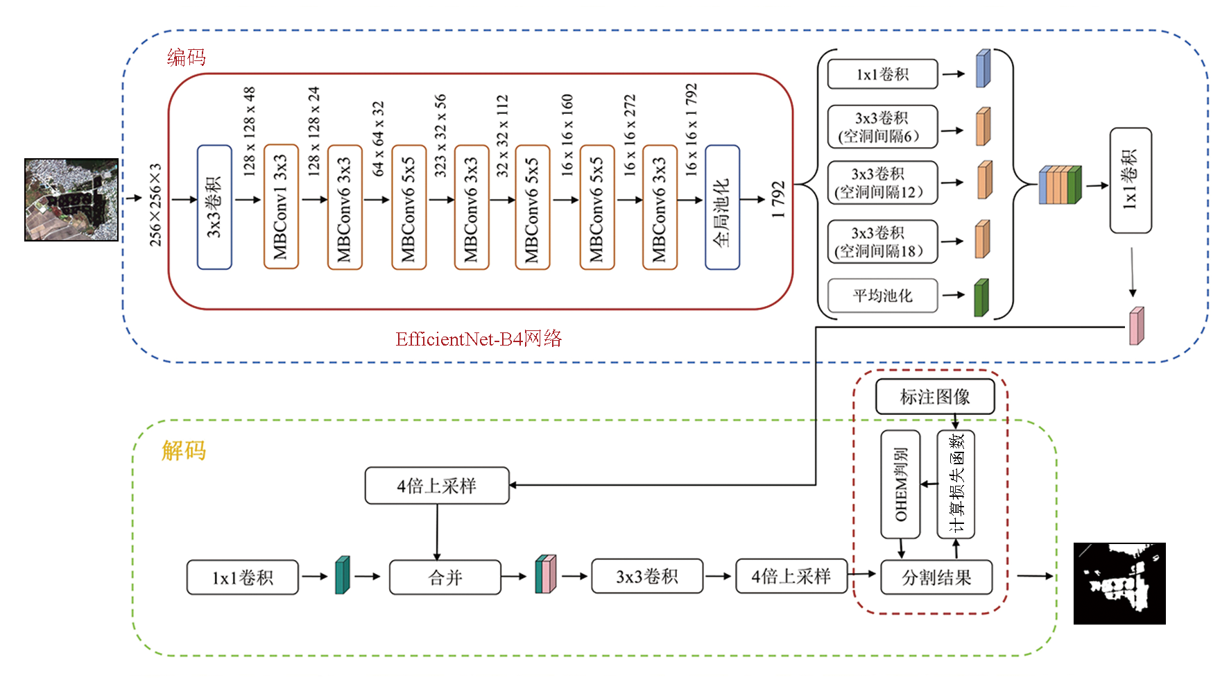
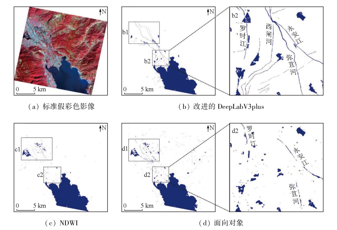
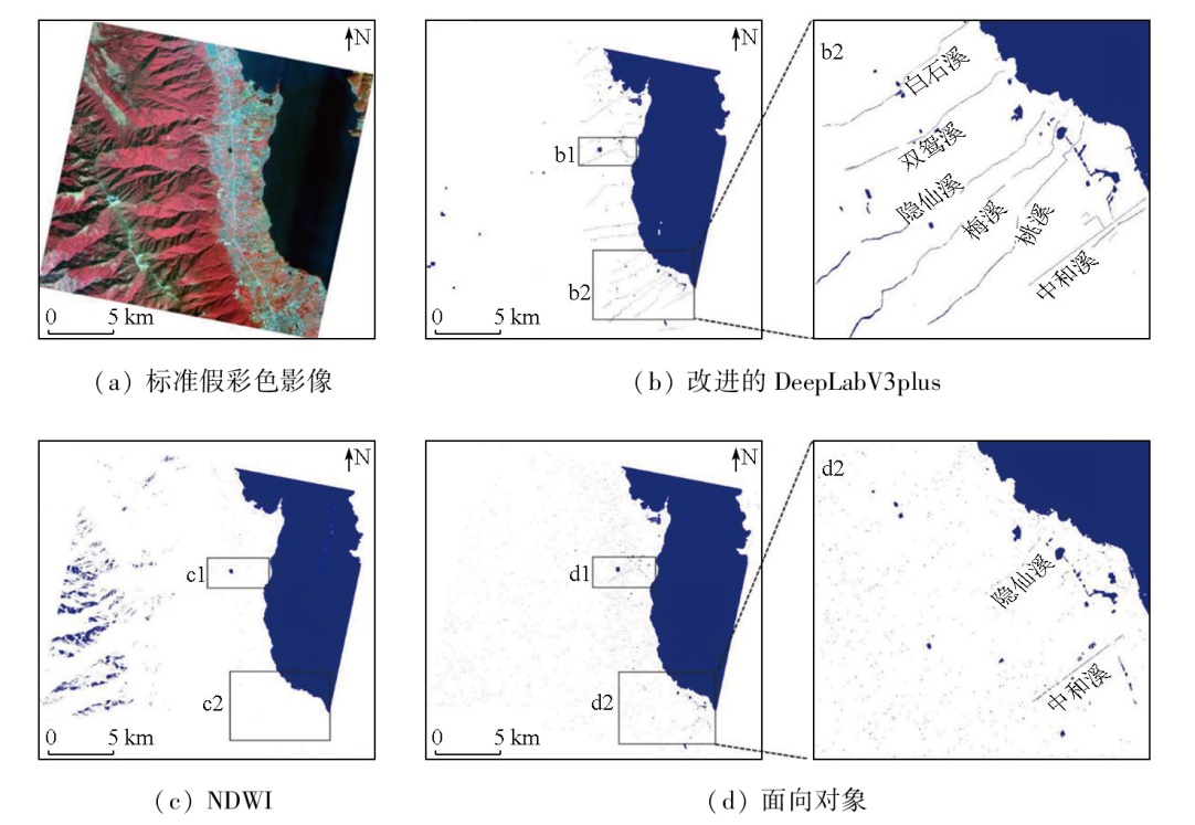
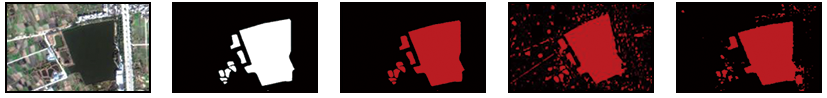
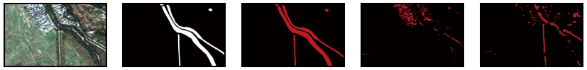
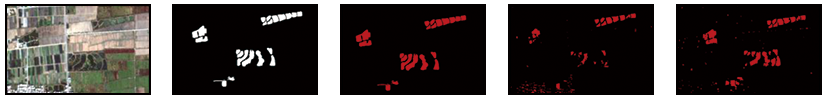
Abstract Traditional methods for information extraction of small water bodies suffer from poor performance and low accuracy, failing to meet actual needs. Using the high-resolution images of the Erhai Lake basin from the Jilin-1 domestic satellite as the data source, this study proposed a deep learning-based semantic segmentation method using an improved DeepLabV3plus model. Replacing the ResNet-101 encoder with EfficientNet-B4, this study innovatively combined the BCE Loss and Dice Loss functions, identifying the optimal method for fine-scale information extraction of water bodies in the Erhai Lake Basin. The results indicate that compared to traditional methods, the improved DeepLabV3plus model performed better in the information extraction of water boundaries, enabling accurate identification of main water bodies, especially small streams. The improved DeepLabV3plus model exhibited higher precision (98.87%), recall (99.30%), and F1-Score (99.08%) than the normalized difference water index (NDWI) and object-oriented methods. Regarding comparison of details, the improved DeepLabV3plus model can effectively suppress the influence of building shadows, vegetation occlusion, and complex surface features, improving the information extraction effects of small water bodies and complex edge areas. In addition, ablation experiments show that the introduction of the combined loss functions and compound scaling strategy increased mIoU by 0.62% and 3.07%, respectively, significantly enhancing the model's segmentation accuracy and ability to extract multi-scale semantic information.
|
| Keywords
improved DeepLabV3plus
high-resolution remote sensing image
semantic segmentation
Erhai Lake Basin
water body information extraction
|
|
|
|
Issue Date: 31 December 2025
|
|
|
| [1] |
Li Z, Zhu Q Q, Yang J H, et al. A cross-domain object-semantic matching framework for imbalanced high spatial resolution imagery water-body extraction[J]. IEEE Transactions on Geoscience and Remote Sensing, 2024,62:5629015.
|
| [2] |
杨先增, 周亚男, 张新, 等. 融合边缘特征与语义信息的人工坑塘精准提取方法[J]. 地球信息科学学报, 2022, 24(4):766-779.
doi: 10.12082/dqxxkx.2022.210489
|
| [2] |
Yang X Z, Zhou Y N, Zhang X, et al. Accurate extraction of artificial pit-pond integrating edge features and semantic information[J]. Journal of Geo-Information Science, 2022, 24(4):766-779.
|
| [3] |
薛源, 覃超, 吴保生, 等. 基于多源国产高分辨率遥感影像的山区河流信息自动提取[J]. 清华大学学报(自然科学版), 2023, 63(1):134-145.
doi: 10.16511/j.cnki.qhdxxb.2022.22.043
|
| [3] |
Xue Y, Qin C, Wu B S, et al. Automatic extraction of mountain river information from multiple Chinese high-resolution remote sensing satellite images[J]. Journal of Tsinghua University (Science and Technology), 2023, 63(1):134-145.
|
| [4] |
徐涵秋. 利用改进的归一化差异水体指数(MNDWI)提取水体信息的研究[J]. 遥感学报, 2005, 9(5):589-595.
|
| [4] |
Xu H Q. A study on information extraction of water body with the modified normalized difference water index (MNDWI)[J]. Journal of Remote Sensing, 2005, 9(5):589-595.
|
| [5] |
Feyisa G L, Meilby H, Fensholt R, et al. Automated water extraction index:A new technique for surface water mapping using Landsat imagery[J]. Remote Sensing of Environment, 2014,140:23-35.
|
| [6] |
王春霞, 张俊, 李屹旭, 等. 一种基于Landsat8的多波段组合水体指数模型[J]. 测绘通报, 2022(5):20-25.
doi: 10.13474/j.cnki.11-2246.2022.0135
|
| [6] |
Wang C X, Zhang J, Li Y X, et al. A multi-band combination water index model based on Landsat8[J]. Bulletin of Surveying and Mapping, 2022(5):20-25.
|
| [7] |
Rishikeshan C A, Ramesh H. An automated mathematical morphology driven algorithm for water body extraction from remotely sensed images[J]. ISPRS Journal of Photogrammetry and Remote Sensing, 2018,146:11-21.
|
| [8] |
李红霞, 石云, 丁中杰, 等. 结合多源遥感数据和面向对象的旱区湿地信息提取[J]. 环境科学, 2025, 46(5):3127-3138.
|
| [8] |
Li H X, Shi Y, Ding Z J, et al. Combining multi-source remote sensing data and object-oriented wetland information extraction in arid areas[J]. Environmental Science, 2025, 46(5):3127-3138.
doi: 10.1021/es204272v
url: https://pubs.acs.org/doi/10.1021/es204272v
|
| [9] |
Shelhamer E, Long J, Darrell T. Fully convolutional networks for semantic segmentation[J]. IEEE Transactions on Pattern Analysis and Machine Intelligence, 2017, 39(4):640-651.
doi: 10.1109/TPAMI.2016.2572683
pmid: 27244717
|
| [10] |
孟月波, 王静, 刘光辉. 多层级特征增强聚合的遥感图像细小水体提取[J]. 探测与控制学报, 2023, 45(6):123-134.
|
| [10] |
Meng Y B, Wang J, Liu G H. Multi-level feature enhancement aggregation for fine water extraction in remote sensing images[J]. Journal of Detection & Control, 2023, 45(6):123-134.
|
| [11] |
Tan M, Le Q. EfficientNet:Rethinking model scaling for convolutional neural networks[C]// Proceedings of the 36th International Conference on Machine Learning. PMLR, 2019:6105-6114.
|
| [12] |
杨品燕, 李绍媛. 洱海流域环境保护和综合管理浅析[J]. 绿色科技, 2019(14):197-198.
|
| [12] |
Yang P Y, Li S Y. Analysis on environmental protection and comprehensive management in Erhai Lake Basin[J]. Journal of Green Science and Technology, 2019(14):197-198.
|
| [13] |
何紫玲, 陈运春, 郭晓飞, 等. 基于FSO算法的洱海流域土地利用分类适用性研究[J]. 农业工程, 2024, 14(9):126-133.
|
| [13] |
He Z L, Chen Y C, Guo X F, et al. Applicability of land use classification in Erhai Basin based on FSO algorithm[J]. Agricultural Engineering, 2024, 14(9):126-133.
|
| [14] |
贾波. 基于高分一号卫星影像的水体信息提取方法初探[J]. 经纬天地, 2024(3):6-10.
|
| [14] |
Jia B. Preliminary exploration on water body information extraction method based on Gaofen No.1 satellite image[J]. Survey World, 2024(3):6-10.
|
| [15] |
Shorten C, Khoshgoftaar T M. A survey on image data augmentation for deep learning[J]. Journal of Big Data, 2019, 6(1):60.
doi: 10.1186/s40537-019-0197-0
|
| [16] |
毛转梅, 刘青, 彭尔瑞, 等. 基于NEWI模型的典型岩溶区普者黑流域水体信息提取[J]. 中国农村水利水电, 2021(1):71-75.
|
| [16] |
Mao Z M, Liu Q, Peng E R, et al. Puzhehei River Basin water body information extraction based on the typical karst area of NEWI model[J]. China Rural Water and Hydropower, 2021(1):71-75.
|
| [17] |
马丹华, 崔雯卓, 冯雪娇, 等. 一种多水体类型地区的坑塘水面精准提取方法[J]. 测绘科学, 2023, 48(11):104-116.
|
| [17] |
Ma D H, Cui W Z, Feng X J, et al. A method for accurately extracting the water surface of pits and ponds in areas with multiple water body types[J]. Science of Surveying and Mapping, 2023, 48(11):104-116.
|
| [18] |
王钰, 董亚坤, 何紫玲, 等. 基于Sentinel-2A影像的复合轮作种植结构提取[J]. 南方农业学报, 2023, 54(8):2490-2498.
|
| [18] |
Wang Y, Dong Y K, He Z L, et al. Extraction of compound rotation planting structure based on Sentinel-2A image[J]. Journal of Southern Agriculture, 2023, 54(8):2490-2498.
|
| [19] |
董哲, 王凌, 朱西存, 等. 光谱模型结合面向对象法的山区水体提取[J]. 遥感信息, 2022, 37(4):121-127.
|
| [19] |
Dong Z, Wang L, Zhu X C, et al. Water extraction in mountainous area based on spectral model and object-oriented method[J]. Remote Sensing Information, 2022, 37(4):121-127.
|
| [20] |
申秋慧, 张宏军, 徐有为, 等. 知识图谱嵌入模型中的损失函数研究综述[J]. 计算机科学, 2023, 50(4):149-158.
doi: 10.11896/jsjkx.211200175
|
| [20] |
Shen Q H, Zhang H J, Xu Y W, et al. Comprehensive survey of loss functions in knowledge graph embedding models[J]. Computer Science, 2023, 50(4):149-158.
doi: 10.11896/jsjkx.211200175
|
| [21] |
南国君, 王敏, 都海波, 等. 基于改进Deeplabv3+模型的遥感影像地物语义分割方法研究[J]. 控制与决策, 2025, 40(2):423-431.
|
| [21] |
Nan G J, Wang M, Du H B, et al. The research on semantic segmentation of remote sensing image about ground objects based on improved Deeplabv3+ model[J]. Control and Decision, 2025, 40(2):423-431.
|
| [22] |
Zhou Z W, Siddiquee M M R, Tajbakhsh N, et al. UNet++:A nest-ed U-Net architecture for medical image segmentation[J/OL]. 2018(2018-07-18).https://arxiv.org/abs/1807.10165v1.
url: https://arxiv.org/abs/1807.10165v1
|
| [23] |
Sandler M, Howard A, Zhu M, et al. MobileNetV2:Inverted residuals and linear bottlenecks[C]// Proceedings of the IEEE Conference on Computer Vision and Pattern Recognition (CVPR). IEEE, 2018:4510-4520.
|
| [24] |
张雨林, 蒋昌波, 隆院男, 等. 基于Sentinel-1A SAR的洞庭湖汛期水体面积动态变化监测研究[J]. 遥感技术与应用, 2024, 39(3):741-752.
doi: 10.11873/j.issn.1004-0323.2024.3.0741
|
| [24] |
Zhang Y L, Jiang C B, Long Y N, et al. Dynamic monitoring of water area in Dongting Lake during flood season based on sentinel-1A SAR data[J]. Remote Sensing Technology and Application, 2024, 39(3):741-752.
|
| [25] |
乔丹玉, 郑进辉, 鲁晗, 等. 面向不同环境背景的Landsat影像水体提取方法适用性研究[J]. 地球信息科学学报, 2021, 23(4):710-722.
doi: 10.12082/dqxxkx.2021.200312
|
| [25] |
Qiao D Y, Zheng J H, Lu H, et al. Application of water extraction methods from Landsat imagery for different environmental background[J]. Journal of Geo-Information Science, 2021, 23(4):710-722.
|
| [26] |
温泉, 李璐, 熊立, 等. 基于深度学习的遥感图像水体提取综述[J]. 自然资源遥感, 2024, 36(3):57-71.doi:10.6046/zrzyyg.2023106.
|
| [26] |
Wen Q, Li L, Xiong L, et al. A review of water body extraction from remote sensing images based on deep learning[J]. Remote Sensing for Natural Resources, 2024, 36(3):57-71.doi:10.6046/zrzyyg.2023106.
|
| [27] |
Li X, Strahler A H. Geometric-optical bidirectional reflectance modeling of the discrete crown vegetation canopy:Effect of crown shape and mutual shadowing[J]. IEEE Transactions on Geoscience and Remote Sensing, 1992, 30(2):276-292.
doi: 10.1109/36.134078
url: http://ieeexplore.ieee.org/document/134078/
|
| [28] |
李文涛, 童鑫, 李冬瑞, 等. 亚米级宽幅卫星边缘视场影像的DSM生成研究[J]. 遥感信息, 2024, 39(2):61-69.
|
| [28] |
Li W T, Tong X, Li D R, et al. Production of DSM based on image located at edge of view of sub meter WFV satellite[J]. Remote Sensing Information, 2024, 39(2):61-69.
|
| [29] |
Small C. The Landsat ETM+ spectral mixing space[J]. Remote Sensing of Environment, 2004, 93(1/2):1-17.
doi: 10.1016/j.rse.2004.06.007
url: https://linkinghub.elsevier.com/retrieve/pii/S0034425704001919
|
| [30] |
谢文春, 李强峰, 李艳春, 等. 基于面向对象的吉林一号遥感影像湿地植被群落分类[J]. 林业资源管理, 2023(1):141-152.
|
| [30] |
Xie W C, Li Q F, Li Y C, et al. Object-oriented classification of wetland vegetation community in Jilin-1 remote sensing image[J]. Forest Resources Management, 2023(1):141-152.
|
|
Viewed |
|
|
|
Full text
|
|
|
|
|
Abstract
|
|
|
|
|
Cited |
|
|
|
|
| |
Shared |
|
|
|
|
| |
Discussed |
|
|
|
|
 2025,
Vol. 37
2025,
Vol. 37