|
|
|
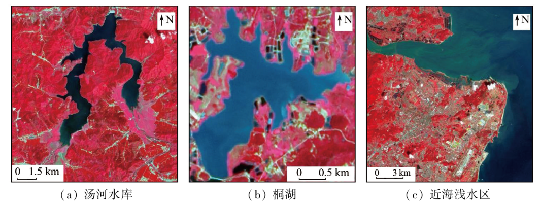
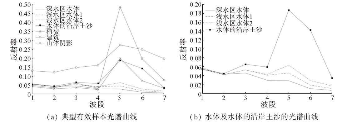
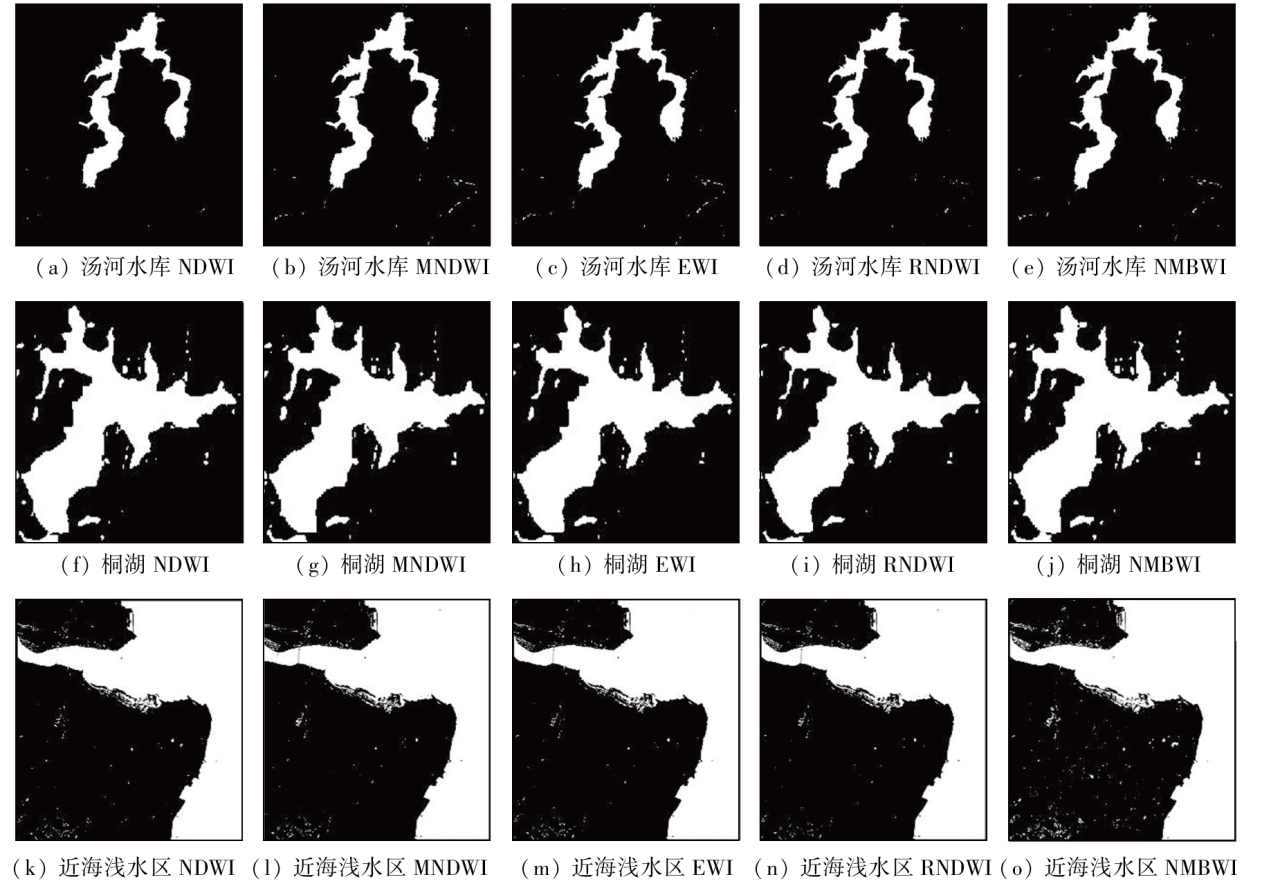
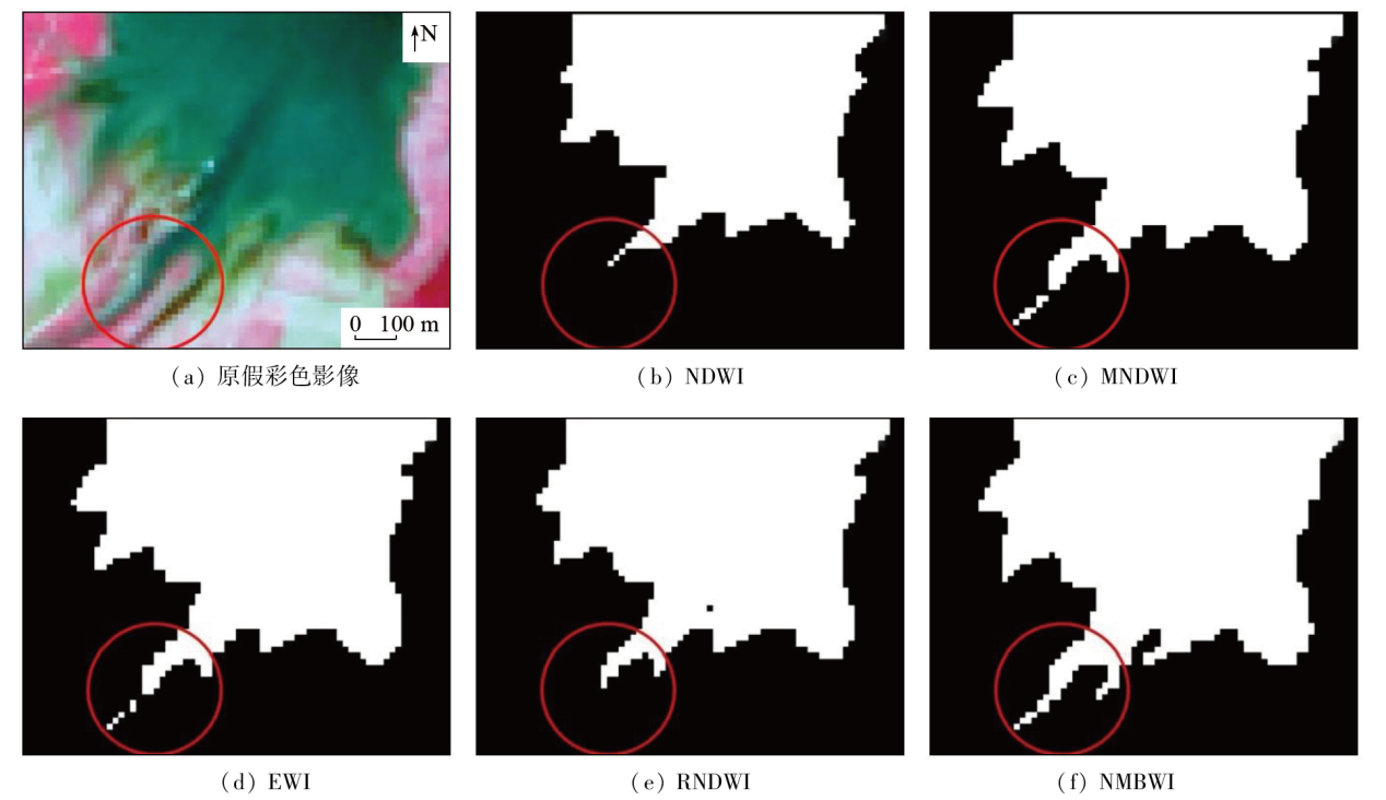
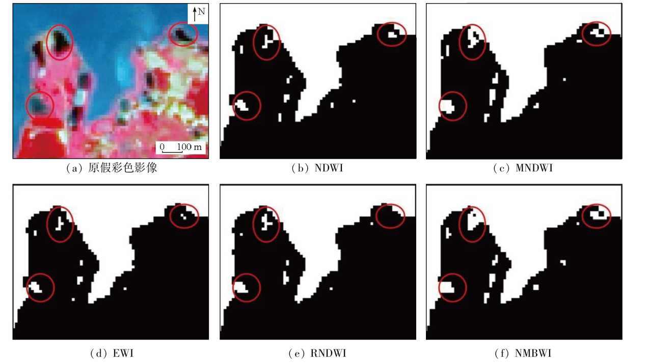
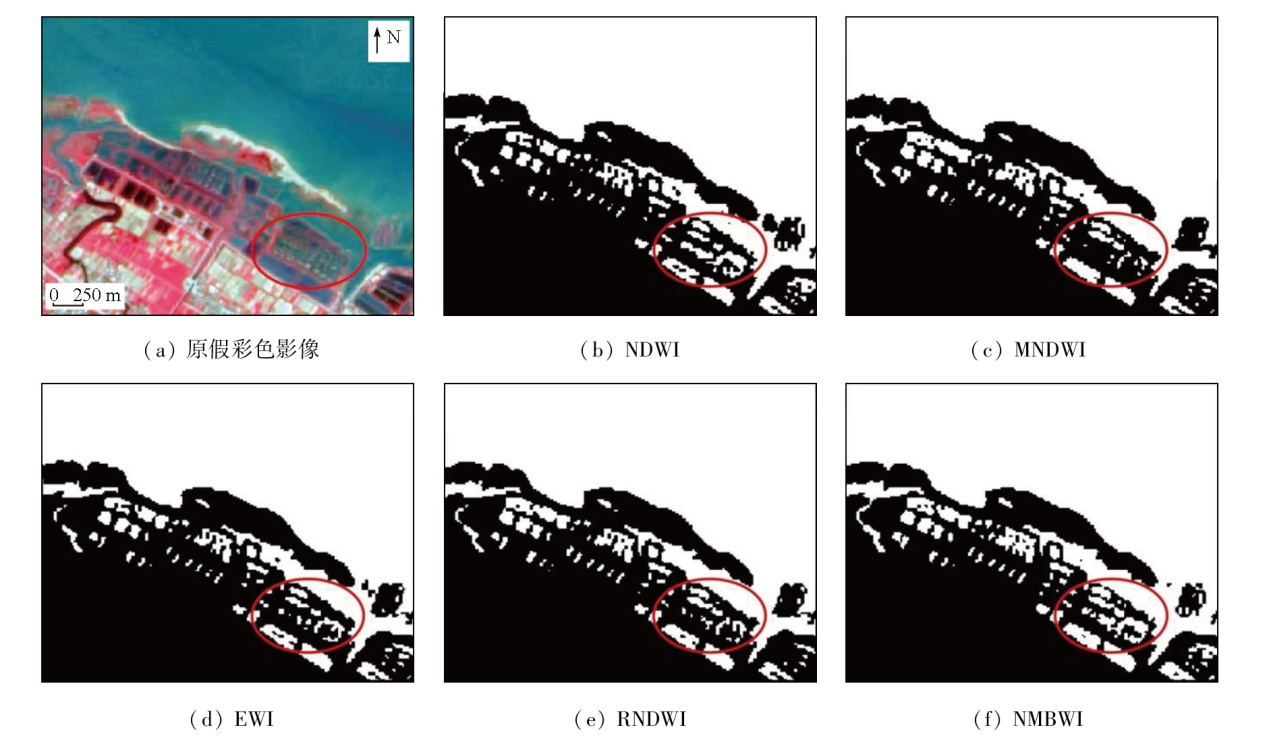
Abstract Traditional water-body index models exhibit high susceptibility to sediments in the shallow water areas at the boundaries of water bodies. This susceptibility leads to challenges such as water misclassification and omissions during water information extraction. Focusing on the Tanghe Reservoir, Tonghu Lake, and shallow offshore areas, this study developed a new multi-band water index (NMBWI) based on the spectral information of typical surface features derived from Landsat images. The comparison with traditional water-index models, including NDWI, MNDWI, EWI, and RNDWI, reveals that NMBWI can significantly enhance the detection effects of shallow water areas at water body boundaries, resulting in more comprehensive extraction results of water areas. NMBWI outperforms traditional water index models in terms of overall accuracy and Kappa coefficient. Furthermore, NMBWI demonstrates high universality and stability in the information extraction of shallow water areas across various water body boundaries.
|
| Keywords
new multi band water index
water body information extraction
shallow water zone
water-body index model
|
|
|
|
Issue Date: 23 December 2024
|
|
|
| [1] |
陈宗定, 许春雪. 守护生命之源——关注水体富营养化[J]. 自然资源科普与文化, 2021(2):30-33.
|
| [1] |
Chen Z D, Xu C X. Protecting the source of life-paying attention to eutrophication of water body[J]. Scientific and Cultural Popularization of Natural Resources, 2021(2):30-33.
|
| [2] |
邱柯卫. 渗透蒸发法海水淡化过程研究[D]. 天津: 天津大学, 2020.
|
| [2] |
Qiu K W. Study on seawater desalination process by pervaporation[D]. Tianjin: Tianjin University, 2020.
|
| [3] |
刘敏, 黄金辉, 彭振华, 等. 利用0.5 m分辨率卫星数据提取深圳市内浅水水体[J]. 测绘通报, 2023(6):146-149,175.
doi: 10.13474/j.cnki.11-2246.2023.0184
|
| [3] |
Liu M, Huang J H, Peng Z H, et al. Extraction of shallow water bodies in Shenzhen using 0.5 m resolution satellite data[J]. Bulletin of Surveying and Mapping, 2023(6):146-149,175.
doi: 10.13474/j.cnki.11-2246.2023.0184
|
| [4] |
任超, 邓诗琴, 高懋芳. 一种提取北部湾沿海地区水体信息的动态阈值方法[J]. 测绘通报, 2022(5):14-19,37.
doi: 10.13474/j.cnki.11-2246.2022.0134
|
| [4] |
Ren C, Deng S Q, Gao M F. A method for extracting dynamic threshold value of water body information in Beibu Gulf coastal area[J]. Bulletin of Surveying and Mapping, 2022(5):14-19,37.
doi: 10.13474/j.cnki.11-2246.2022.0134
|
| [5] |
黄效淳, 陈圣波, 张斌, 等. 基于长时间序列遥感影像的查干湖水体面积变化分析[J]. 世界地质, 2023, 42(1):176-183.
|
| [5] |
Huang X C, Chen S B, Zhang B, et al. Analysis of water area change in Chagan Lake based on long period remote sensing data[J]. World Geology, 2023, 42(1):176-183.
|
| [6] |
王瑶瑶, 谭秀翠, 董洁, 等. 基于遥感数据的东平湖面积变化监测[J]. 山东农业大学学报(自然科学版), 2020, 51(4):655-659.
|
| [6] |
Wang Y Y, Tan X C, Dong J, et al. Monitoring for Dongping Lake area variation based on remote sensing data[J]. Journal of Shandong Agricultural University (Natural Science Edition), 2020, 51(4):655-659.
|
| [7] |
Deng Y, Jiang W, Tang Z, et al. Long-term changes of open-surface water bodies in the Yangtze River basin based on the Google Earth Engine cloud platform[J]. Remote Sensing, 2019, 11(19):2213.
|
| [8] |
McFeeters S K. The use of the normalized difference water index (NDWI) in the delineation of open water features[J]. International Journal of Remote Sensing, 1996, 17(7):1425-1432.
|
| [9] |
徐涵秋. 利用改进的归一化差异水体指数(MNDWI)提取水体信息的研究[J]. 遥感学报, 2005, 9(5):589-595.
|
| [9] |
Xu H Q. A study on information extraction of water body with the modified normalized difference water index (MNDWI)[J]. Journal of Remote Sensing, 2005, 9(5):589-595.
|
| [10] |
闫霈, 张友静, 张元. 利用增强型水体指数(EWI)和GIS去噪音技术提取半干旱地区水系信息的研究[J]. 遥感信息, 2007, 22(6):62-67.
|
| [10] |
Yan P, Zhang Y J, Zhang Y. A study on information extraction of water system in semi-arid regions with the enhanced water index(EWI) and GIS based noise remove techniques[J]. Remote Sensing Information, 2007, 22(6):62-67.
|
| [11] |
曹荣龙, 李存军, 刘良云, 等. 基于水体指数的密云水库面积提取及变化监测[J]. 测绘科学, 2008, 33(2):158-160.
|
| [11] |
Cao R L, Li C J, Liu L Y, et al. Extracting Miyun reservoir’s water area and monitoring its change based on a revised normalized different water index[J]. Science of Surveying and Mapping, 2008, 33(2):158-160.
|
| [12] |
李健锋, 叶虎平, 张宗科, 等. 基于Landsat影像的斯里兰卡内陆湖库水体时空变化分析[J]. 地球信息科学学报, 2019, 21(5):781-788.
doi: 10.12082/dqxxkx.2019.180643.
|
| [12] |
Li J F, Ye H P, Zhang Z K, et al. Spatiotemporal change analysis of Sri Lanka inland water based on landsat imagery[J]. Journal of Geo-Information Science, 2019, 21(5):781-788.
|
| [13] |
孙根云, 邵宝婕, 丁孙金衍, 等. 基于GEE平台的黄河流域水体指数研究[J]. 人民黄河, 2023, 45(3):119-124.
|
| [13] |
Sun G Y, Shao B J, Ding S, et al. Research on Yellow River basin water index based on GEE platform[J]. Yellow River, 2023, 45(3):119-124.
|
| [14] |
肖茜, 杨昆, 洪亮. 近30 a云贵高原湖泊表面水体面积变化遥感监测与时空分析[J]. 湖泊科学, 2018, 30(4):1083-1096.
|
| [14] |
Xiao Q, Yang K, Hong L. Remote sensing monitoring and temporal-spatial analysis of surface water body area changes of lakes on the Yunnan-Guizhou Plateau over the past 30 years[J]. Journal of Lake Sciences, 2018, 30(4):1083-1096.
|
| [15] |
韩伟孝, 黄春林, 王昀琛, 等. 基于长时序Landsat 5/8多波段遥感影像的青海湖面积变化研究[J]. 地球科学进展, 2019, 34(4):346-355.
doi: 10.11867/j.issn.1001-8166.2019.4.0346
|
| [15] |
Han W X, Huang C L, Wang Y C, et al. Study on the area variation of Qinghai Lake based on long-term landsat 5/8 multi-band remote sensing imagery[J]. Advances in Earth Science, 2019, 34(4):346-355.
doi: 10.11867/j.issn.1001-8166.2019.4.0346
|
| [16] |
王小标, 谢顺平, 都金康. 水体指数构建及其在复杂环境下有效性研究[J]. 遥感学报, 2018, 22(2):360-372.
|
| [16] |
Wang X B, Xie S P, Du J K. Water index formulation and its effectiveness research on the complicated surface water surroundings[J]. Journal of Remote Sensing, 2018, 22(2):360-372.
|
| [17] |
骈蔚然, 张莉, 耿晴. 基于山地水体指数的水体边界提取方法[J]. 地理空间信息, 2022, 20(3):25-29.
|
| [17] |
Pian W R, Zhang L, Geng Q. Water boundary extraction method based on mountain water index[J]. Geospatial Information, 2022, 20(3):25-29.
|
| [18] |
王春霞, 张俊, 李屹旭, 等. 一种基于Landsat8的多波段组合水体指数模型[J]. 测绘通报, 2022(5):20-25.
doi: 10.13474/j.cnki.11-2246.2022.0135
|
| [18] |
Wang C X, Zhang J, Li Y X, et al. A multi-band combination water index model based on Landsat8[J]. Bulletin of Surveying and Mapping, 2022(5):20-25.
|
|
Viewed |
|
|
|
Full text
|
|
|
|
|
Abstract
|
|
|
|
|
Cited |
|
|
|
|
| |
Shared |
|
|
|
|
| |
Discussed |
|
|
|
|
 2024,
Vol. 36
2024,
Vol. 36
 ), WANG Chongchang(