|
|
 |
|

|
|
|
Spatiotemporal evolution and trade-off/synergy analysis of ecosystem services in the Xi’an section of the Qinling Mountains |
ZHANG Yiwen1( ), LI Fengxia2(), ZHANG Rui1, FENG Xiaogang2, LI Meng2, HU Moqing2 ), LI Fengxia2(), ZHANG Rui1, FENG Xiaogang2, LI Meng2, HU Moqing2 |
1. School of Resources Engineering, Xi’an University of Architecture and Technology, Xi’an 710055, China
2. School of Architecture, Xi’an University of Architecture and Technology, Xi’an 710055, China |
|
|
|
|
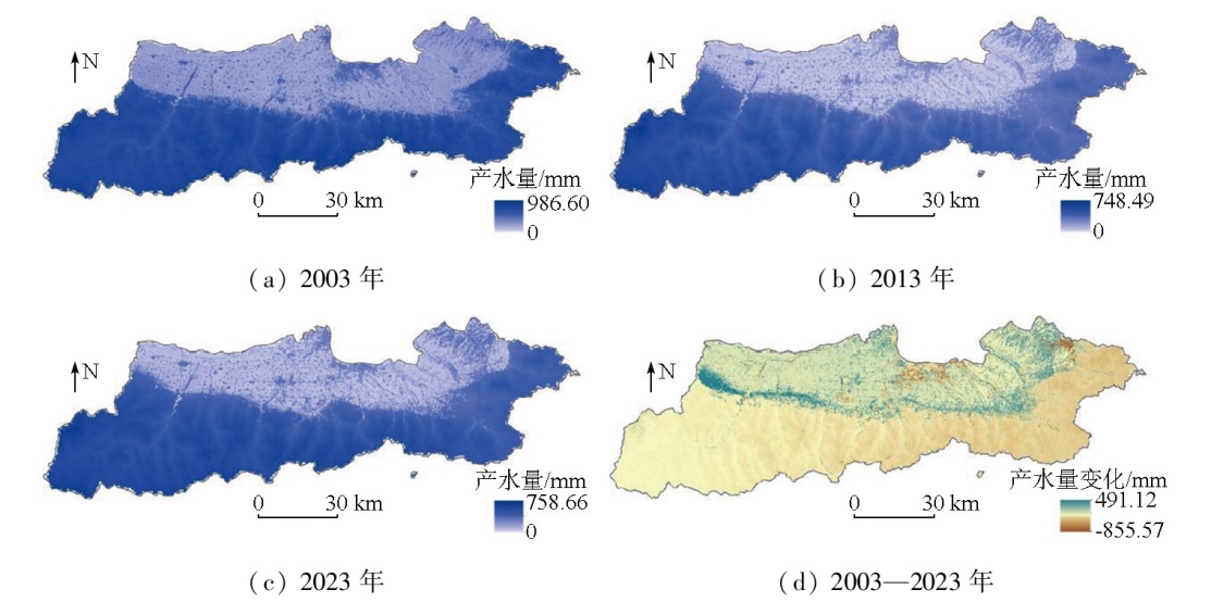
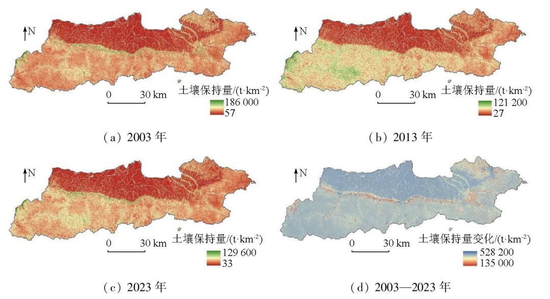
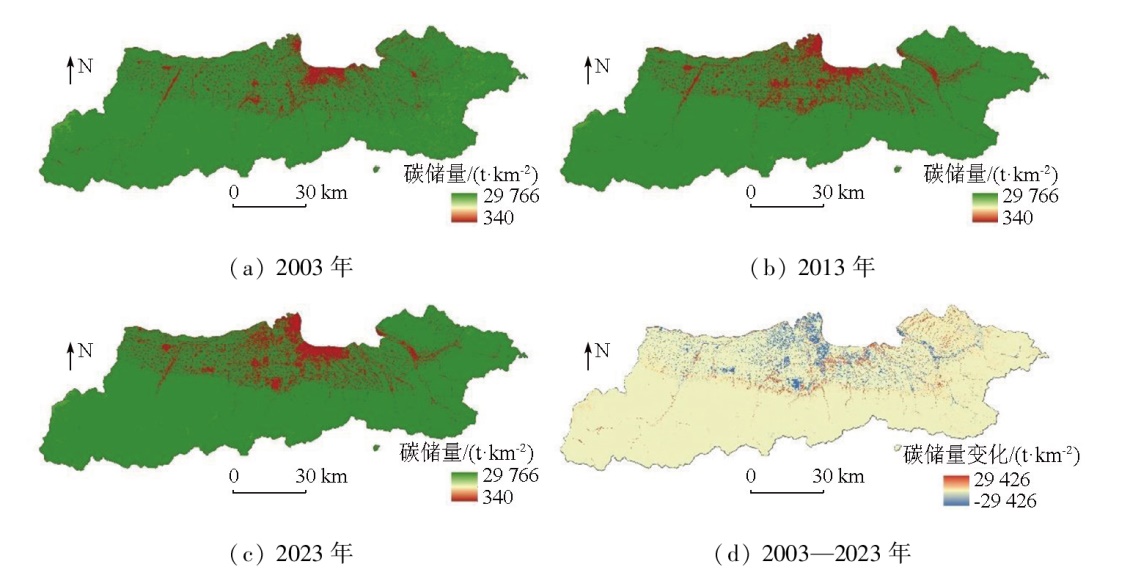
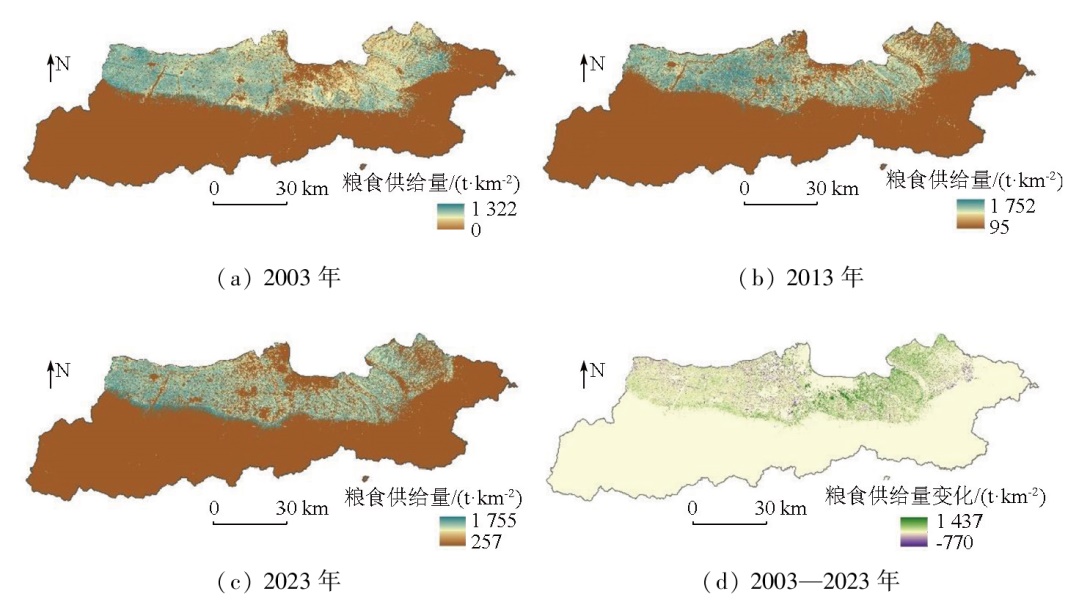
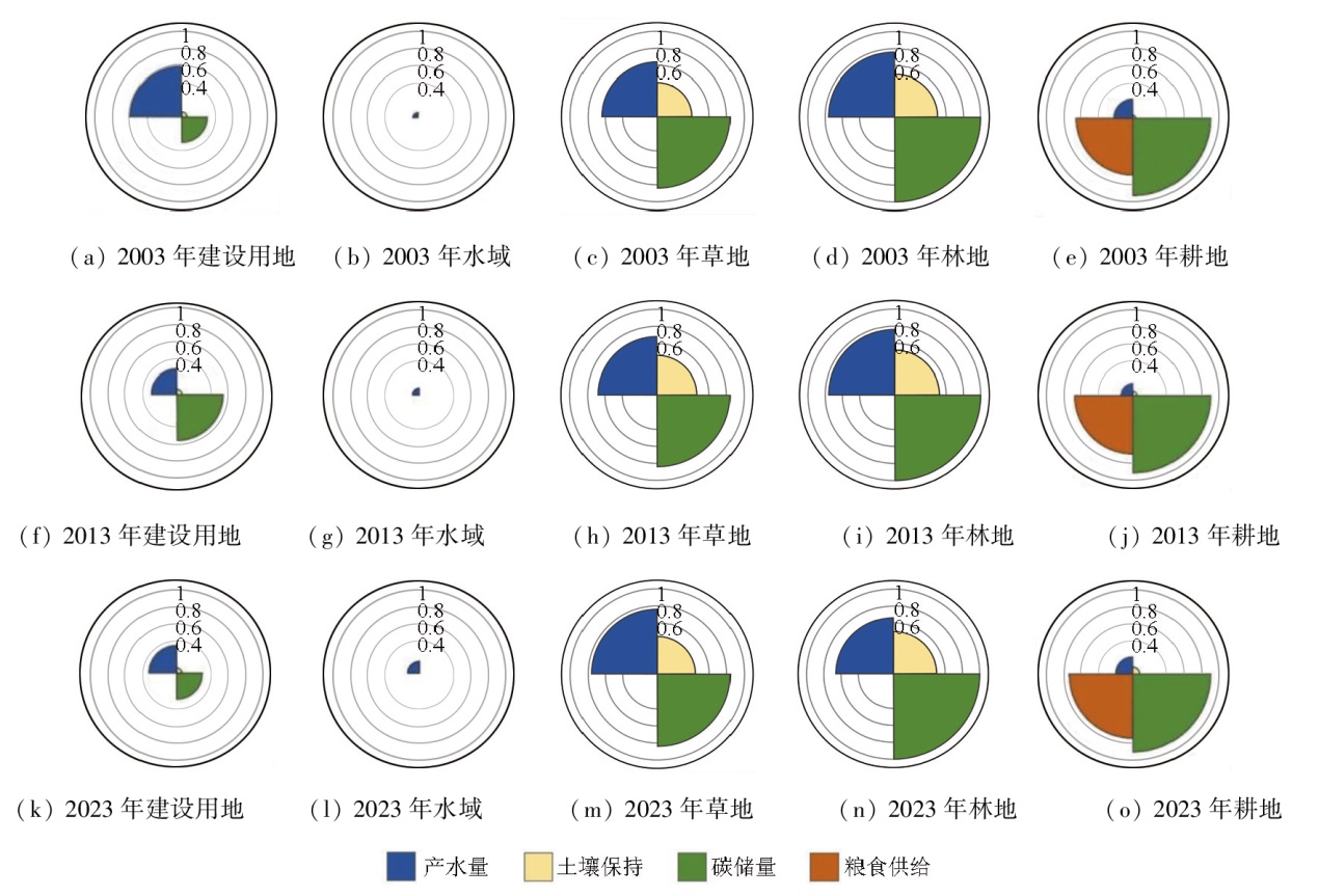
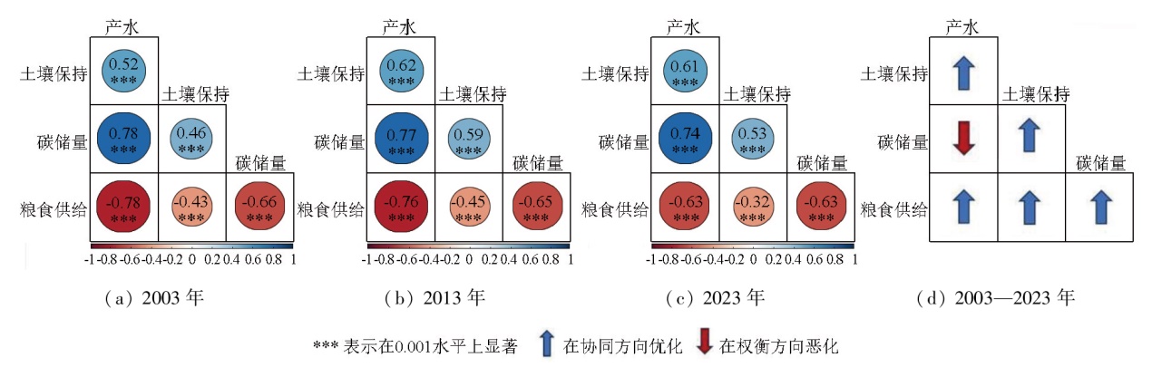
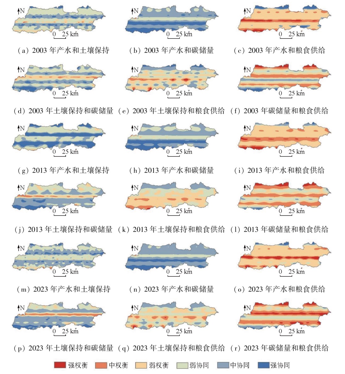
Abstract This study aims to investigate the spatiotemporal evolution and trade-off/synergy relationships of ecosystem services in the Xi'an section of the Qinling Mountains. To this end, it quantitatively assessed the spatiotemporal evolution patterns of four ecosystem services-water yield, soil conservation, carbon reserves, and food supply-from 2003 to 2023 based on the integrated valuation of ecosystem services and trade-offs (InVEST) model. By integrating Spearman's rank correlation coefficient and geographically weighted regression (GWR), this study identified and quantified trade-off/synergy relationships among ecosystem services. Finally, the impacts of changes in land use on ecosystem services were analyzed. The results showed that water yield and soil conservation generally showed a rapidly decreasing trend followed by a slow increase, while carbon reserves and food supply exhibited a slow decline. In addition, synergistic relationships were observed between water yield and soil conservation, between water yield and carbon reserves, and between carbon reserves and soil conservation. In contrast, trade-off relationships were identified between food supply and water production, soil conservation, and carbon reserves. In the study area, increases in forestland and grassland led to a diminution in water yield. The expansion of construction land and the loss of arable land resources directly triggered a reduction in carbon reserves, while an increase in forestland contributed to soil conservation. These findings can provide a scientific basis for the eco-environmental protection and sustainable development of the Qinling area.
|
| Keywords
land use change
ecosystem service
integrated valuation of ecosystem services and trade-offs (InVEST) model
tradeoff/synergy
|
|
|
|
Issue Date: 31 December 2025
|
|
|
| [1] |
傅伯杰, 周国逸, 白永飞, 等. 中国主要陆地生态系统服务功能与生态安全[J]. 地球科学进展, 2009, 24(6):571-576.
doi: 10.11867/j.issn.1001-8166.2009.06.0571
|
| [1] |
Fu B J, Zhou G Y, Bai Y F, et al. The main terrestrial ecosystem services and ecological security in China[J]. Advances in Earth Science, 24(6):571-576.
|
| [2] |
戴尔阜, 王晓莉, 朱建佳, 等. 生态系统服务权衡/协同研究进展与趋势展望[J]. 地球科学进展, 2015, 30(11):1250-1259.
doi: 10.11867/j.issn.1001-8166.2015.11.1250
|
| [2] |
Dai E F, Wang X L, Zhu J J, et al. Progress and perspective on ecosystem services trade-offs[J]. Advances in Earth Science, 2015, 30(11):1250-1259.
doi: 10.11867/j.issn.1001-8166.2015.11.1250
|
| [3] |
王建庆. 东南沿海地区城镇土地利用效益评价研究——以浙江省百强县为例[D]. 宁波: 宁波大学, 2014.
|
| [3] |
Wang J Q. Study on the evaluation of land use efficiency in the town of southeast coastal areas:In case of the top 100 counties in Zhejiang[D]. Ningbo: Ningbo University, 2014.
|
| [4] |
Song W, Deng X Z. Land-use/land-cover change and ecosystem service provision in China[J]. Science of The Total Environment, 2017,576:705-719.
|
| [5] |
Shifaw E, Sha J M, Li X M, et al. Ecosystem services dynamics and their influencing factors:Synergies/tradeoffs interactions and implications,the case of upper Blue Nile Basin,Ethiopia[J]. Science of The Total Environment, 2024,938:173524.
|
| [6] |
Xia H, Yuan S F, Prishchepov A V. Spatial-temporal heterogeneity of ecosystem service interactions and their social-ecological drivers:Implications for spatial planning and management[J]. Resources,Conservation and Recycling, 2023,189:106767.
|
| [7] |
Zhang J W, Wang M, Liu K, et al. Social-ecological system sustainability in China from the perspective of supply-demand balance for ecosystem services[J]. Journal of Cleaner Production, 2025,497:145039.
|
| [8] |
于媛, 韩玲, 李明玉, 等. 哈长城市群生态系统服务时空特征及其权衡/协同关系研究[J]. 水土保持研究, 2021, 28(2):293-300.
|
| [8] |
Yu Y, Han L, Li M Y, et al. Study on the spatial-temporal characteristics of ecosystem services and tradeoffs/synergies in the Ha-Chang urban agglomeration[J]. Research of Soil and Water Conservation, 2021, 28(2):293-300.
|
| [9] |
龙文芹, 职露, 郭娅迪, 等. 西洞庭湖自然保护区2000—2020 年间碳储量时空演变及成因分析[J]. 自然资源遥感, 2024, 36(4):185-192.doi:10.6046/zrzyyg.2023265.
|
| [9] |
Long W Q, Zhi L, Guo Y D, et al. Spatiotemporal evolution and origin of carbon stock in the West Dongting Lake National Nature Reserve over the last two decades[J]. Remote Sensing for Natural Resources, 2024, 36(4):185-192.doi:10.6046/zrzyyg.2023265.
|
| [10] |
崔璐. 秦岭陕西段生态系统服务评估及多情景预测研究[D]. 西安: 长安大学, 2023.
|
| [10] |
Cui L. Ecosystem service assessment and multi-scenario prediction in the Shaanxi section of the Qinling Mountains[D]. Xi’an: Chang’an University, 2023.
|
| [11] |
丘海红, 胡宝清, 张泽. 基于土地利用变化的广西近20年生态系统服务价值研究[J]. 环境工程技术学报, 2022, 12(5):1455-1465.
|
| [11] |
Qiu H H, Hu B Q, Zhang Z. Study on ecosystem service value of Guangxi in the past 20 years based on land use change[J]. Journal of Environmental Engineering Technology, 2022, 12(5):1455-1465.
|
| [12] |
李丹, 周嘉, 战大庆. 黑龙江省耕地时空变化及驱动因素分析[J]. 地理科学, 2021, 41(7):1266-1275.
doi: 10.13249/j.cnki.sgs.2021.07.017
|
| [12] |
Li D, Zhou J, Zhan D Q. Spatial and temporal changes and driving factors of cultivated land in Heilongjiang Province[J]. Scientia Geographica Sinica, 2021, 41(7):1266-1275.
doi: 10.13249/j.cnki.sgs.2021.07.017
|
| [13] |
牛乐乐, 张必成, 贾天忠, 等. 青海省海西州土地利用变化强度分析与稳定性研究[J]. 水土保持学报, 2021, 35(2):152-159.
|
| [13] |
Niu L L, Zhang B C, Jia T Z, et al. Analysis on intensity and stabi-lity of land use change in Haixi Mongolian and Tibetan Autonomous Prefecture of Qinghai Province[J]. Journal of Soil and Water Conservation, 2021, 35(2):152-159.
|
| [14] |
朱灵伟, 陈晨, 彭云飞, 等. 基于LUCC强度图谱的耕地时空演变模式研究[J]. 中国国土资源经济, 2024, 37(12):52-63.
|
| [14] |
Zhu L W, Chen C, Peng Y F, et al. A study on spatiotemporal evolution patterns of cultivated land based on LUCC intensity chroma-togram[J]. Natural Resource Economics of China, 2024, 37(12):52-63.
|
| [15] |
李帅呈, 龚健, 杨建新, 等. 兰西城市群土地利用/覆被变化模式特征——基于强度分析框架[J]. 资源科学, 2023, 45(3):480-493.
doi: 10.18402/resci.2023.03.02
|
| [15] |
Li S C, Gong J, Yang J X, et al. Characteristics of LUCC patterns of the Lanzhou-Xining urban agglomeration:Based on an intensity analysis framework[J]. Resources Science, 2023, 45(3):480-493.
doi: 10.18402/resci.2023.03.02
|
| [16] |
范亚宁, 刘康, 陈姗姗, 等. 秦岭北麓陆地生态系统水源涵养功能的空间格局[J]. 水土保持通报, 2017, 37(2):50-56.
|
| [16] |
Fan Y N, Liu K, Chen S S, et al. Spatial pattern analysis on water conservative functionality of land ecosystem in northern slope of Qinling Mountains[J]. Bulletin of Soil and Water Conservation, 2017, 37(2):50-56.
|
| [17] |
周苹苹, 罗艺, 宋小燕, 等. 基于InVEST-PLUS模型的陕西省水源涵养量估算及预测[J]. 水土保持学报, 2024, 38(3):187-194.
|
| [17] |
Zhou P P, Luo Y, Song X Y, et al. Estimation and prediction of water conservation capacity in Shaanxi Province based on the InVEST-PLUS model[J]. Journal of Soil and Water Conservation, 2024, 38(3):187-194.
|
| [18] |
翟睿洁, 赵文武, 贾立志. 基于RUSLE、InVEST 和USPED 的土壤侵蚀量估算对比研究——以陕北延河流域为例[J]. 农业现代化研究, 2020, 41(6):1059-1068.
|
| [18] |
Zhai R J, Zhao W W, Jia L Z. A comparative study of soil erosion estimation based on RUSLE,InVEST and USPED models:A case study of Yanhe River Basin in Northern Shaanxi[J]. Research of Agricultural Modernization, 2020, 41(6):1059-1068.
|
| [19] |
李倩, 王成军, 冯涛, 等. 基于SD-PLUS耦合模型的陕西省土地利用变化及碳储量多情景预测[J]. 水土保持学报, 2024, 38(3):195-206,215.
|
| [19] |
Li Q, Wang C J, Feng T, et al. Multi-scenario prediction of land use change and carbon storage in Shaanxi Province based on the SD-PLUS coupled model[J]. Journal of Soil and Water Conservation, 2024, 38(3):195-206,215.
|
| [20] |
赵文亮, 贺振, 贺俊平, 等. 基于MODIS-NDVI的河南省冬小麦产量遥感估测[J]. 地理研究, 2012, 31(12):2310-2320.
|
| [20] |
Zhao W L, He Z, He J P, et al. Remote sensing estimation for winter wheat yield in Henan based on the MODIS-NDVI data[J]. Geographical Research, 2012, 31(12):2310-2320.
|
| [21] |
周凡, 周冬梅, 金银丽, 等. 疏勒河流域生态系统服务供需空间匹配特征[J]. 干旱区地理, 2023, 46(3):471-480.
doi: 10.12118/j.issn.1000-6060.2022.337
|
| [21] |
Zhou F, Zhou D M, Jin Y L, et al. Spatial matching characteristics of supply and demand of ecosystem services in the Shule River Basin[J]. Arid Land Geography, 2023, 46(3):471-480.
doi: 10.12118/j.issn.1000-6060.2022.337
|
| [22] |
武文欢, 彭建, 刘焱序, 等. 鄂尔多斯市生态系统服务权衡与协同分析[J]. 地理科学进展, 2017, 36(12):1571-1581.
doi: 10.18306/dlkxjz.2017.12.012
|
| [22] |
Wu W H, Peng J, Liu Y X, et al. Tradeoffs and synergies between ecosystem services in Ordos City[J]. Progress in Geography, 2017, 36(12):1571-1581.
doi: 10.18306/dlkxjz.2017.12.012
|
| [23] |
刘纪远, 宁佳, 匡文慧, 等. 2010—2015年中国土地利用变化的时空格局与新特征[J]. 地理学报, 2018, 73(5):789-802.
doi: 10.11821/dlxb201805001
|
| [23] |
Liu J Y, Ning J, Kuang W H, et al. Spatio-temporal patterns and characteristics of land-use change in China during 2010—2015[J]. Acta Geographica Sinica, 2018, 73(5):789-802.
|
| [24] |
魏培洁, 吴明辉, 贾映兰, 等. 基于InVEST模型的疏勒河上游产水量时空变化特征分析[J]. 生态学报, 2022, 42(15):6418-6429.
|
| [24] |
Wei P J, Wu M H, Jia Y L, et al. Spatiotemporal variation of water yield in the upstream regions of the Shule River Basin using the InVEST Model[J]. Acta Ecologica Sinica, 2022, 42(15):6418-6429.
|
| [25] |
胡文敏, 杨睿瀚, 贾冠宇, 等. 长江流域产水功能对土地利用变化的响应及其驱动因素[J]. 生态学报, 2022, 42(17):7011-7027.
|
| [25] |
Hu W M, Yang R H, Jia G Y, et al. Response of water yield function to land use change and its driving factors in the Yangtze River Basin[J]. Acta Ecologica Sinica, 2022, 42( 17) :7011-7027.
|
| [26] |
贾纪昂, 郭伟玲, 徐刘洋, 等. 耦合PLUS-InVEST-GeoDetector模型的安徽省碳储量时空演变及驱动力分析[J]. 环境科学, 2025, 46(3):1703-1715.
|
| [26] |
Jia J A, Guo W L, Xu L Y, et al. Spatio-temporal evolution and driving force analysis of carbon storage in Anhui Province coupled with PLUS-InVEST-GeoDetector model[J]. Environmental Science, 2025, 46(3):1703-1715.
|
| [27] |
Martens B, Miralles D G, Lievens H, et al. GLEAM v4.2a:Global land evaporation amsterdam model dataset[EB/OL].[2025-04-01].https://www.gleam.eu.
url: https://www.gleam.eu
|
|
Viewed |
|
|
|
Full text
|
|
|
|
|
Abstract
|
|
|
|
|
Cited |
|
|
|
|
| |
Shared |
|
|
|
|
| |
Discussed |
|
|
|
|
 2025,
Vol. 37
2025,
Vol. 37