Please wait a minute...
 
国土资源遥感  2018, Vol. 30 Issue (2): 80-86    DOI: 10.6046/gtzyyg.2018.02.11
     技术方法 本期目录 | 过刊浏览 | 高级检索 |
多流形LE算法在高光谱图像降维和分类上的应用
吴东洋(), 马丽()
中国地质大学(武汉)机械与电子信息学院,武汉 430074
Multi-manifold LE algorithm for dimension reduction and classification of multitemporal hyperspectral image
Dongyang WU(), Li MA()
School of Mechanical Engineering and Electronic Information,China University of Geosciences(Wuhan), Wuhan 430074, China
全文: PDF(3210 KB)   HTML  
输出: BibTeX | EndNote (RIS)      
摘要 

传统的流形学习算法假设不同类的数据位于同一个流形结构上,然而由于不同类别数据的特征不同,其位于各自不同的流形结构上的假设更加合理,因此,多流形假设更适合数据分类问题。通过借鉴多流形谱聚类算法中的多流形思想,研究多流形LE算法及其在高光谱数据降维和分类上的应用,结合高光谱数据特点,通过添加空间信息和数据标记信息进一步改进多流形LE算法。实验结果表明,在多种高光谱数据中,多流形LE算法能取得比LE算法更高的分类精度,同时改进的多流形LE算法也取得比LE和多流形LE算法更高的分类精度,这说明多流形假设更符合高光谱数据的特点,也说明了改进算法的有效性。

服务
把本文推荐给朋友
加入引用管理器
E-mail Alert
RSS
作者相关文章
吴东洋
马丽
关键词 流形学习多流形假设高光谱数据分类    
Abstract

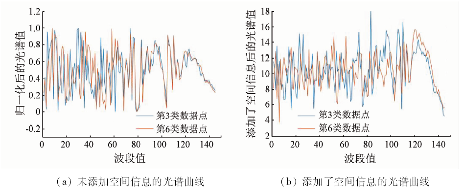
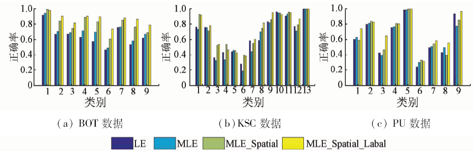
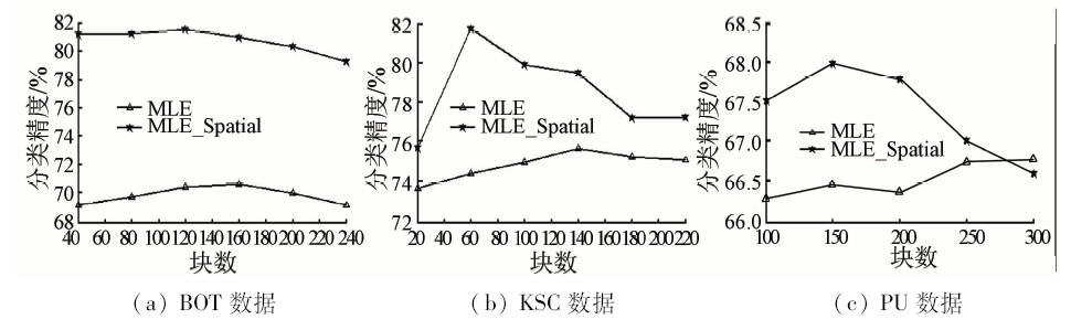
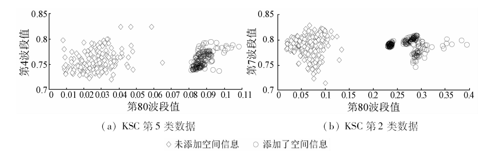
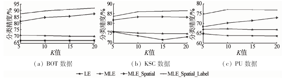
The traditional manifold learning algorithms are based on the assumption that categories of data are located in the same manifold structure; nevertheless, due to the different features of different data categories, it is more reasonable that the data are in respective different manifold structures. Hence, the assumption of multi-manifold is more applicable for data classification. This paper adopts the thought of multi-manifold spectral clustering algorithm, mainly focuses on multiple manifolds LE algorithm, and applies this algorithm to the processing of hyperspectral data. Combined with the features of the hyperspectral data, the multiple manifolds LE algorithm is further improved by adding the spatial information and data maker information. The experimental results show that, in many kinds of hyperspectral data, the multi-manifold LE algorithm has higher precision than the LE algorithm. In addition, the improved multi-manifold LE algorithm could classify data with higher precision than the LE algorithm and multi-manifold LE algorithm. The authors have reached the conclusion that the assumption of multi-manifold is in better agreement with the features of hyperspectral data and the improved algorithm is of high performance.

Key wordsmanifold learning    multi-manifold hypothesis    hyperspectral data    classification
收稿日期: 2016-07-25      出版日期: 2018-05-30
:  TP79  
通讯作者: 马丽
引用本文:   
吴东洋, 马丽. 多流形LE算法在高光谱图像降维和分类上的应用[J]. 国土资源遥感, 2018, 30(2): 80-86.
Dongyang WU, Li MA. Multi-manifold LE algorithm for dimension reduction and classification of multitemporal hyperspectral image. Remote Sensing for Land & Resources, 2018, 30(2): 80-86.
链接本文:  
https://www.gtzyyg.com/CN/10.6046/gtzyyg.2018.02.11      或      https://www.gtzyyg.com/CN/Y2018/V30/I2/80
Fig.1  添加空间信息前后的光谱曲线对比
Fig.2  为块赋类别
算法 训练数据比例
10% 30% 50%
LE 0.666 0.742 0.766
MLE 0.706 0.783 0.800
MLE_Spatial 0.875 0.915 0.929
MLE_Spatial_Label 0.920 0.954 0.970
Tab.1  不同算法在BOT数据上的最优总体分类精度
算法 训练数据比例
10% 30% 50%
LE 0.754 0.796 0.812
MLE 0.756 0.806 0.821
MLE_Spatial 0.834 0.880 0.893
MLE_Spatial_Label 0.865 0.913 0.918
Tab.2  不同算法在KSC数据上的最优总体分类精度
算法 训练数据比例
10% 30% 50%
LE 0.646 0.667 0.670
MLE 0.670 0.720 0.731
MLE_Spatial 0.730 0.770 0.786
MLE_Spatial_Label 0.771 0.845 0.846
Tab.3  不同算法在PU数据上的最优总体分类精度
Fig.3  不同数据各类的分类精度
纯净点数 块数
40 80 120 160 200 240
未添加空间信息时 275 418 558 689 758 853
添加空间信息时 654 1 047 1 254 1 392 1 480 1 502
  BOT数据(1 580个点)不同块数对应的纯净点数
纯净点数 块数
20 60 100 140 180 220
未添加空间信息时 484 565 655 814 879 949
添加空间信息时 564 952 1 105 1 231 1 284 1 357
  KSC数据(1 870个点)不同块数对应的纯净点数
纯净点数 块数
100 150 200 250 300
未添加空间信息时 313 434 554 683 793
添加空间信息时 812 1 078 1 294 1 460 1 564
  PU数据(2 138个点)不同块数对应的纯净点数
Fig.4  不同块数下的分类精度
Fig.5  同一类数据在添加空间信息前后2个波段的数据分布
Fig.6  不同邻域大小的最优分类精度
[1] Tenenbaum J B, De Silva V, Langford J C . A global geometric framework for nonlinear dimensionality reduction[J]. Science, 2000,290(5500):2319-2923.
doi: 10.1126/science.290.5500.2319
[2] Belkin M, Niyogi P . Laplacian eigenmaps for dimensionality reduction and data representation[J]. Neural Computation, 2003,15(6):1373-1396.
doi: 10.1162/089976603321780317
[3] Roweis S T, Saul L K . Nonlinear dimensionality reduction by locally linear embedding[J]. Science, 2000,290(5500):2323-2326.
doi: 10.1126/science.290.5500.2323
[4] Zhang Z Y, Zha H Y . Principal manifolds and nonlinear dimensionality reduction via tangent space alignment[J]. Journal of Shanghai University (English Edition), 2004,8(4):406-424.
doi: 10.1137/S1064827502419154
[5] Yan S C, Xu D, Zhang B Y , et al. Graph embedding and extensions:A general framework for dimensionality reduction[J]. IEEE Transactions on Pattern Analysis and Machine Intelligence, 2007,29(1):40-51.
doi: 10.1109/TPAMI.2007.250598
[6] Xiao R, Zhao Q J, Zhang D , et al. Facial expression recognition on multiple manifolds[J]. Pattern Recognition, 2011,44(1):107-116.
doi: 10.1016/j.patcog.2010.07.017
[7] He X F, Niyogi P. Locality preserving projections [C]//Advances in Neural Information Processing Systems. 2003: 186-197.
[8] Huang H B, Huo H, Fang T . Hierarchical manifold learning with applications to supervised classification for high-resolution remotely sensed images[J]. IEEE Transactions on Geoscience and Remote Sensing, 2014,52(3):1677-1692.
doi: 10.1109/TGRS.2013.2253559
[9] 高琰, 谷士文, 唐琎 , 等. 机器学习中谱聚类方法的研究[J]. 计算机科学, 2007,34(2):201-203.
doi: 10.3969/j.issn.1002-137X.2007.02.051
Gao Y, Gu S W, Tang J , et al. Research on spectral clustering in machine learning[J]. Computer Science, 2007,34(2):201-203.
[10] Wang Y, Jiang Y, Wu Y , et al. Spectral clustering on multiple manifolds[J]. IEEE Transactions on Neural Networks, 2011,22(7):1149-1161.
doi: 10.1109/TNN.2011.2147798 pmid: 21690009
[11] 戴竹红, 塔西甫拉提·特依拜.遥感影像中同谱异类问题的研究[J].中国科技信息, 2006(20):278-280.
Dai Z H, Tashpolat ·Tiyip . Research on same spectrum with different objects in remote sensing image[J].China Science and Technology Information, 2006(20):278-280.
[1] 史飞飞, 高小红, 肖建设, 李宏达, 李润祥, 张昊. 基于集成学习和多时相遥感影像的枸杞种植区分类[J]. 自然资源遥感, 2022, 34(1): 115-126.
[2] 吴琳琳, 李晓燕, 毛德华, 王宗明. 基于遥感和多源地理数据的城市土地利用分类[J]. 自然资源遥感, 2022, 34(1): 127-134.
[3] 李渊, 毋琳, 戚雯雯, 郭拯危, 李宁. 基于改进OGMRF-RC模型的SAR图像分类方法[J]. 自然资源遥感, 2021, 33(4): 98-104.
[4] 范莹琳, 娄德波, 张长青, 魏英娟, 贾福东. 基于面向对象的铁尾矿信息提取技术研究——以迁西地区北京二号遥感影像为例[J]. 自然资源遥感, 2021, 33(4): 153-161.
[5] 白俊龙, 王章琼, 闫海涛. K-means聚类引导的无人机遥感图像阈值分类方法[J]. 自然资源遥感, 2021, 33(3): 114-120.
[6] 王镕, 赵红莉, 蒋云钟, 何毅, 段浩. 月尺度农作物提取中GF-1 WFV纹理特征的应用及分析[J]. 自然资源遥感, 2021, 33(3): 72-79.
[7] 蒋校, 钟昶, 连铮, 吴亮廷, 邵治涛. 卫星遥感地质信息产品分类标准研究进展[J]. 自然资源遥感, 2021, 33(3): 279-283.
[8] 韩彦岭, 崔鹏霞, 杨树瑚, 刘业锟, 王静, 张云. 基于残差网络特征融合的高光谱图像分类[J]. 国土资源遥感, 2021, 33(2): 11-19.
[9] 孟清, 白红英, 赵婷, 郭少壮, 齐贵增. 秦岭山地对气溶胶的生态屏障效应[J]. 国土资源遥感, 2021, 33(1): 240-248.
[10] 许赟, 许艾文. 基于随机森林的遥感影像云雪雾分类检测[J]. 国土资源遥感, 2021, 33(1): 96-101.
[11] 张莉, 谢亚楠, 屈辰阳, 汪鸣泉, 常征, 王茂华. 基于K-Means城市分类算法的夜光遥感电力消费估算[J]. 国土资源遥感, 2020, 32(4): 182-189.
[12] 王德军, 姜琦刚, 李远华, 关海涛, 赵鹏飞, 习靖. 基于Sentinel-2A/B时序数据与随机森林算法的农耕区土地利用分类[J]. 国土资源遥感, 2020, 32(4): 236-243.
[13] 王跃峰, 武慧智, 何姝珺, 黄頔, 白朝军. 河南省信阳市浉河区自然资源智能化信息提取技术方法研究[J]. 国土资源遥感, 2020, 32(4): 244-250.
[14] 孙珂. 融合超像元与峰值密度特征的遥感影像分类[J]. 国土资源遥感, 2020, 32(4): 41-45.
[15] 江珊, 王春, 宋宏利, 刘玉锋. 基于SAR与光学遥感数据相结合的农作物种植类型识别研究[J]. 国土资源遥感, 2020, 32(4): 105-110.
Viewed
Full text


Abstract

Cited

  Shared   
  Discussed   
京ICP备05055290号-2
版权所有 © 2015 《自然资源遥感》编辑部
地址:北京学院路31号中国国土资源航空物探遥感中心 邮编:100083
电话:010-62060291/62060292 E-mail:zrzyyg@163.com
本系统由北京玛格泰克科技发展有限公司设计开发