Please wait a minute...
 
国土资源遥感  2019, Vol. 31 Issue (3): 209-215    DOI: 10.6046/gtzyyg.2019.03.26
  技术应用 本期目录 | 过刊浏览 | 高级检索 |
2013—2017年班公湖地区冷季湖泊冰情变化分析——中国西部高寒高海拔地区冰冻圈遥感调查(一)
燕云鹏1, 徐辉2(), 刘刚1, 刘建宇1
1. 中国自然资源航空物探遥感中心,北京 100083
2. 中国科学院大气物理研究所大气科学和地球流体力学数值模拟国家重点实验室,北京 100029
Analysis of the variations of the lake ice phenology in the Pangong Lake area from 2013 to 2017: Remote sensing survey of the cryosphere in the high altitude and alpine region, West China(Ⅰ)
Yunpeng YAN1, Hui XU2(), Gang LIU1, Jianyu LIU1
1. China Aero Geophysical Survey and Remote Sensing Center for Natural Resources, Beijing 100083, China
2. State Key Laboratory of Numerical Modeling for Atmospheric Sciences and Geophysical Fluid Dynamics (LASG),Institute of Atmospheric Physics, Chinese Academy of Sciences, Beijing 100029, China
全文: PDF(1974 KB)   HTML  
输出: BibTeX | EndNote (RIS)      
摘要 

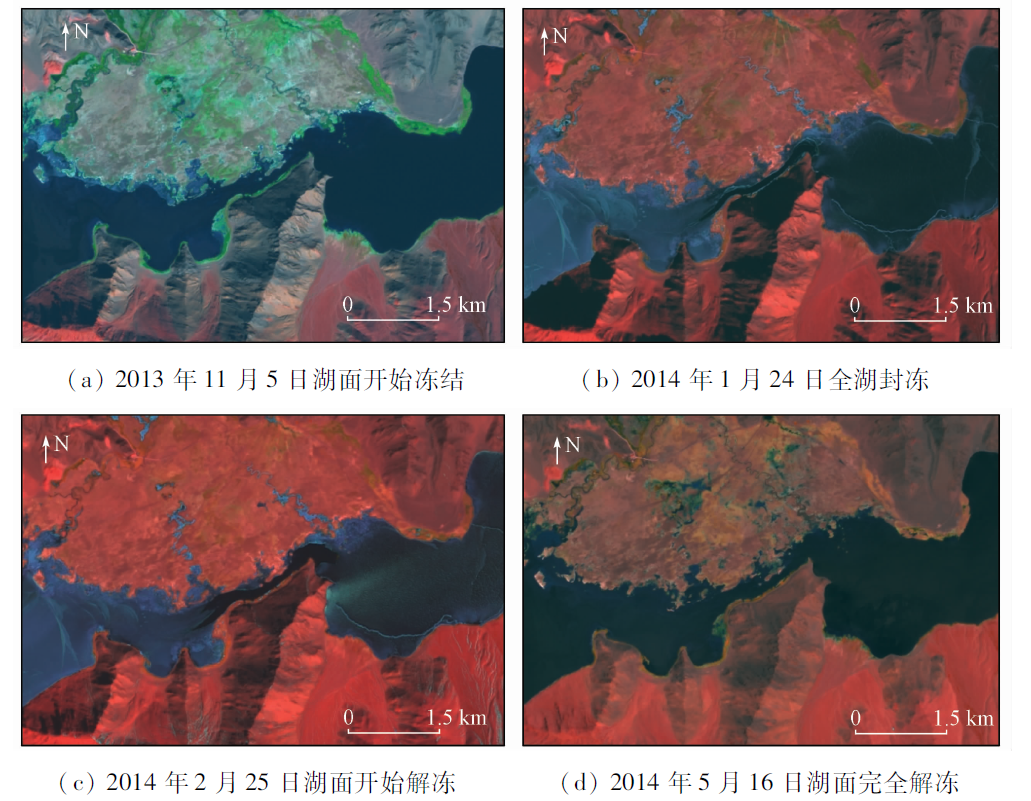
开展高寒高海拔区域的湖泊冰情变化分析,对于冷季湖冰通行能力评价、暖季冰碛湖溃决防灾减灾以及湖区下游洪涝灾害预测,均具有重要意义。基于2013—2017年Landsat8陆地成像仪(operational land imager,OLI)传感器获得的遥感数据序列,选择了班公湖地区4个有代表性的湖泊(区域),开展了冷季湖泊冰情变化分析,调查结果显示班公湖Zone1区和Zone2区作为同一个湖泊,冻结开始时间、封冻时间、解冻开始时间和完全解冻开始时间基本一致。尽管斯潘古尔湖和莫里里湖的湖面海拔比班公湖高,但是冻结过程三者基本一致。斯潘古尔湖解冻比班公湖要晚; 而最终的完全解冻开始时间两者基本一致。莫里里湖的解冻开始时间比班公湖要晚0.5~1个月; 而完全解冻时间比别的湖泊约晚1个月。

服务
把本文推荐给朋友
加入引用管理器
E-mail Alert
RSS
作者相关文章
燕云鹏
徐辉
刘刚
刘建宇
关键词 中国西部高寒高海拔冰冻圈遥感湖泊冰情班公湖    
Abstract

The analysis of the lake ice phenology in the high altitude and alpine area is of great significance for traffic capacity assessment on the lake ice in the cold season, disaster prevention and reduction of moraine lake burst and prediction on the flood disaster of the lower reaches in the warm season. On the basis of the OLI data from 2013 to 2017, four typical lakes(areas)in the Pangong Lake area were chosen for the analysis of the lake ice phenology in winter. The results show that the starting freeze time, the time of maximum ice amount, starting thaw time and totally thaw time of Zone1 and Zone2 in the Pangong Lake were almost simultaneous. Although Spanggur Lake and Moriri Lake both have higher altitude than Pangong Lake, and they shared the similar freeze processes. The starting thaw time of Spanggur Lake was later than Pangong Lake, while the totally thaw time was almost the same. The starting thaw time of Moriri Lake was about half to one month later than that of Pangong Lake, and the totally thaw time was one month later than other three lakes.

Key wordsWest China    high altitude and alpine region    cryosphere    remote sensing    lake    ice phenology    Pangong Lake
收稿日期: 2018-07-06      出版日期: 2019-08-30
:  TP79  
基金资助:中国地质调查局项目“西北边境地区国土资源遥感综合调查”(12120113003300);“西部边境阿克苏—防城港地区综合遥感地质调查与应用项目”(DD20190545);“全国边海防地区基础地质遥感调查”共同资助(DD2016007)
通讯作者: 徐辉
作者简介: 燕云鹏(1977-),男,教授级高级工程师,主要从事环境地质遥感调查应用研究。Email: ypyan@sohu.com.。
引用本文:   
燕云鹏, 徐辉, 刘刚, 刘建宇. 2013—2017年班公湖地区冷季湖泊冰情变化分析——中国西部高寒高海拔地区冰冻圈遥感调查(一)[J]. 国土资源遥感, 2019, 31(3): 209-215.
Yunpeng YAN, Hui XU, Gang LIU, Jianyu LIU. Analysis of the variations of the lake ice phenology in the Pangong Lake area from 2013 to 2017: Remote sensing survey of the cryosphere in the high altitude and alpine region, West China(Ⅰ). Remote Sensing for Land & Resources, 2019, 31(3): 209-215.
链接本文:  
https://www.gtzyyg.com/CN/10.6046/gtzyyg.2019.03.26      或      https://www.gtzyyg.com/CN/Y2019/V31/I3/209
Fig.1  研究区湖泊分布
(Landsat8 OLI B7(R),B5(G),B4(B)假彩色合成)
期次 本期次起止时间 本期次时
间跨度
与前一期次
的间隔
期次 本期次起止时间 本期次时
间跨度
与前一期次
的间隔
1 1105—1116 12 8 次年0302—次年0313 12 16
2 1121—1202 12 16 9 次年0318—次年0321 4 12
3 1207—1218 12 16 10 次年0329—次年0403 6 12
4 1223—次年0103 12 16 11 次年0411—次年0422 12 16
5 次年0111—次年0124 14 20 12 次年0503—次年0516 14 23
6 次年0130—次年0212 14 19 13 次年0519—次年0529 11 14
7 次年0215—次年0225 11 14
Tab.1  Landsat8遥感影像期次分布
湖泊名称 中心坐标 湖水面
积/km2
湖面高
程/m
经度 纬度
班公湖Zone1区 E79.00° N33.74° 39 4 245
班公湖Zone2区 E79.62° N33.67° 45 4 245
斯潘古尔湖 E78.90° N33.50° 58 4 296
莫里里湖 E78.30° N32.90° 144 4 527
Tab.2  监测对象的主要属性
年度 第1期
(1111)
第2期
(1127)
第3期
(1213)
第4期
(1229)
第5期
(次年0118)
第6期
(次年0206)
第7期
(次年0220)
2013—2014年 20131105 20131121 20131207 20131223 20140124 20140209 20140225
2014—2015年 20141108C 20141124 20141210 20141226 20150111 20150212
2015—2016年 20151111 20151213 20151229 20160114C 20160130C 20160215
2016—2017年 20161113 20161129 20161215 20161231 20170115T 20170201 20170217
年度 第8期
(次年0308)
第9期
(次年0320)
第10期
(次年0401)
第11期
(次年0417)
第12期
(次年0501)
第13期
(次年0515)
2013—2014年 20140313 20140329 20140414 20140516
2014—2015年 20150401 20150417 20150503 20150519
2015—2016年 20160302 20160318 20160403 20160419 20160505 20160521
2016—2017年 20170305 20170321 20170422 20170508
Tab.3  班公湖Zone1区冷季湖冰年际动态变化
Fig.2  2013—2014年班公湖Zone1部分区域冷季湖泊冰情变化遥感影像特征
湖泊(区域)冰情
变化基本参数
班公湖
Zone1区
班公湖
Zone2区
斯潘古
尔湖
莫里
里湖
冻结开始时间(最早) 1105 1105 1105 1105
冻结开始时间(最晚) 1113 1113 1113 1113
冻结开始时间跨度/d 9 9 9 9
封冻开始时间(最早) 次年
0111
1226 1229 次年
0111
封冻开始时间(最晚) 次年
0124
次年
0124
次年
0124
次年
0201
湖泊(区域)冰情
变化基本参数
班公湖
Zone1区
班公湖
Zone2区
斯潘古
尔湖
莫里
里湖
封冻开始时间跨度/d 14 30 27 22
解冻开始时间(最早) 次年
0217
次年
0215
次年
0318
次年
0422
解冻开始时间(最晚) 次年
0401
次年
0401
次年
0417
次年
0519
解冻开始时间跨度/d 44 46 31 28
完全解冻开始时间(最早) 次年
0505
次年
0505
次年
0505
次年
0604
完全解冻开始时间(最晚) 次年
0519
次年
0519
次年
0519
次年
0617
完全解冻开始时间跨度/d 15 15 15 14
冰冻期时长(最长)/d 196 196 196 225
冰冻期时长(最短)/d 174 174 174 204
Tab.4  班公湖地区湖泊(区域)冷季湖冰变化基本参数
[1] 杨倩, 吕德昊 . 湖冰物候变化遥感监测研究进展[J].科技风, 2017(17):116-117.
Yang Q, Lyu D H . Progress in remote sensing monitoring of lake ice phenology[J].Technology Wind, 2017(17):116-117.
[2] 燕云鹏, 刘刚, 李瑜 , 等. 西北边境地区冰冻圈遥感调查与监测(2013—2015)主要进展[J]. 中国地质调查, 2017,4(3):51-56.
Yan Y P, Liu G, Li Y , et al. Research achievements on cryosphere investigation and monitoring using remote sensing techniques in the northwest border area from 2013 to 2015[J]. Geological Survey of China, 2017,4(3):51-56.
[3] 曹梅盛, 李新, 陈贤章 , 等. 冰冻圈遥感[M]. 北京: 科学出版社, 2006.
Cao M S, Li X, Chen X Z , et al. Remote Sensing of Cryosphere[M]. Beijing: Science Press, 2006.
[4] 辛羽飞, 卞林根 . 全球冰冻圈变化预测研究现状[J]. 极地研究, 2008,20(3):275-286.
doi: CNKI:SUN:JDYZ.0.2008-03-007
Xin Y F, Bian L G . Progress of prediction of the global cryosphere change[J]. Chinese Journal of Polar Research, 2008,20(3):275-286.
[5] 魏秋芳, 叶庆华 . 湖冰遥感监测方法综述[J]. 地理科学进展, 2010,29(7):803-810.
doi: 10.11820/dlkxjz.2010.07.005
Wei Q F, Ye Q H . Review of lake ice monitoring by remote sensing[J]. Progress in Geogrphy, 2010,29(7):803-810.
[6] 陈贤章, 王光宇, 李文君 , 等. 青藏高原湖冰及其遥感监测[J]. 冰川冻土, 1995,17(3):241-246.
Chen X Z, Wang G Y, Li W J , et al. Lake ice and its remote sensing monitoring in the Tibetan Plateau[J]. Journal of Glaciology and Geocryology, 1995,17(3):241-246.
[7] 王智颖, 吴艳红, 常军 , 等. 青藏高原湖冰物候的时空变化及其影响因素[J]. 北京工业大学学报, 2017,43(5):701-709.
Wang Z Y, Wu Y H, Chang J , et al. Temporal and spatial variation of lake ice phenology and its influencing factor in the Tibetan Plateau[J]. Journal of Beijing University of Technology, 2017,43(5):701-709.
[8] 姚晓军, 李龙, 赵军 , 等. 近10年来可可西里地区主要湖泊冰情时空变化[J]. 地理学报, 2015,70(7):1114-1124.
Yao X J, Li L, Zhao J , et al. Spatial-temporal variations of lake ice in the Hoh Xil region from 2000 to 2011[J]. Acta Geographic Sinica, 2015,70(7):1114-1124.
[9] 赵水霞, 李畅游, 李超 , 等. 黄河什四份子弯道河冰生消及冰塞过程分析[J]. 水利学报, 2017,48(3):351-358.
doi: 10.13243/j.cnki.slxb.20160721
Zhao S X, Li C Y, Li C , et al. Processes of river ice and ice-jam formation in Shensifenzi bend of the Yellow River[J]. Journal of Hydraulic Engineering, 2017,48(3):351-358.
[10] 李超, 李畅游, 赵水霞 , 等, 基于遥感数据的河冰过程解译及分析[J]. 水利水电科技进展, 2016,36(3):52-56.
Li C, Li C Y, Zhao S X , et al. Interpretation and analysis of river ice process based on remote sensing data[J]. Advances in Science and Technology of Water Resources, 2016,36(3):52-56.
[11] 李均力, 盛永伟, 骆剑承 . 喜马拉雅山地区冰湖信息的遥感自动化提取[J]. 遥感学报, 2011,15(1):29-43.
doi: 10.11834/jrs.20110103
Li J L, Sheng Y W, Luo J C , et al. Automatic extaction of Himalayan glacial lakes with remote sensing[J]. Journal of Remote Sensing, 2011,15(1):29-43.
[1] 李伟光, 侯美亭. 植被遥感时间序列数据重建方法简述及示例分析[J]. 自然资源遥感, 2022, 34(1): 1-9.
[2] 丁波, 李伟, 胡克. 基于同期光学与微波遥感的茅尾海及其入海口水体悬浮物反演[J]. 自然资源遥感, 2022, 34(1): 10-17.
[3] 高琪, 王玉珍, 冯春晖, 马自强, 柳维扬, 彭杰, 季彦桢. 基于改进型光谱指数的荒漠土壤水分遥感反演[J]. 自然资源遥感, 2022, 34(1): 142-150.
[4] 张秦瑞, 赵良军, 林国军, 万虹麟. 改进遥感生态指数的宜宾市三江汇合区生态环境评价[J]. 自然资源遥感, 2022, 34(1): 230-237.
[5] 贺鹏, 童立强, 郭兆成, 涂杰楠, 王根厚. 基于地形起伏度的冰湖溃决隐患研究——以希夏邦马峰东部为例[J]. 自然资源遥感, 2022, 34(1): 257-264.
[6] 刘文, 王猛, 宋班, 余天彬, 黄细超, 江煜, 孙渝江. 基于光学遥感技术的冰崩隐患遥感调查及链式结构研究——以西藏自治区藏东南地区为例[J]. 自然资源遥感, 2022, 34(1): 265-276.
[7] 王茜, 任广利. 高光谱遥感异常信息在阿尔金索拉克地区铜金矿找矿工作中的应用[J]. 自然资源遥感, 2022, 34(1): 277-285.
[8] 吕品, 熊丽媛, 徐争强, 周学铖. 基于FME的矿山遥感监测矢量数据图属一致性检查方法[J]. 自然资源遥感, 2022, 34(1): 293-298.
[9] 张大明, 张学勇, 李璐, 刘华勇. 一种超像素上Parzen窗密度估计的遥感图像分割方法[J]. 自然资源遥感, 2022, 34(1): 53-60.
[10] 薛白, 王懿哲, 刘书含, 岳明宇, 王艺颖, 赵世湖. 基于孪生注意力网络的高分辨率遥感影像变化检测[J]. 自然资源遥感, 2022, 34(1): 61-66.
[11] 宋仁波, 朱瑜馨, 郭仁杰, 赵鹏飞, 赵珂馨, 朱洁, 陈颖. 基于多源数据集成的城市建筑物三维建模方法[J]. 自然资源遥感, 2022, 34(1): 93-105.
[12] 艾璐, 孙淑怡, 李书光, 马红章. 光学与SAR遥感协同反演土壤水分研究进展[J]. 自然资源遥感, 2021, 33(4): 10-18.
[13] 李特雅, 宋妍, 于新莉, 周圆锈. 卫星热红外温度反演钢铁企业炼钢月产量估算模型[J]. 自然资源遥感, 2021, 33(4): 121-129.
[14] 刘白露, 管磊. 南海珊瑚礁白化遥感热应力检测改进方法研究[J]. 自然资源遥感, 2021, 33(4): 136-142.
[15] 吴芳, 金鼎坚, 张宗贵, 冀欣阳, 李天祺, 高宇. 基于CZMIL测深技术的海陆一体地形测量初探[J]. 自然资源遥感, 2021, 33(4): 173-180.
Viewed
Full text


Abstract

Cited

  Shared   
  Discussed   
京ICP备05055290号-2
版权所有 © 2015 《自然资源遥感》编辑部
地址:北京学院路31号中国国土资源航空物探遥感中心 邮编:100083
电话:010-62060291/62060292 E-mail:zrzyyg@163.com
本系统由北京玛格泰克科技发展有限公司设计开发