High-efficiency supervision method for green geological exploration based on remote sensing
MA Shibin1,2,3(), PI Yingnan1,2,3(), WANG Jia1,2,3, ZHANG Kun1,2,3, LI Shenghui1,2,3, PENG Xi1,2,3
1. Institute of Geological Survey of Qinghai Province, Xining 810012, China 2. Qinghai-Tibet Plateau During the North Qilian Geology and Mineral Resources Laboratory of Qinghai Province, Xining 810012, China 3. Qinghai Remote Sensing Big Data Engineering Technology Research Center, Xining 810012, China
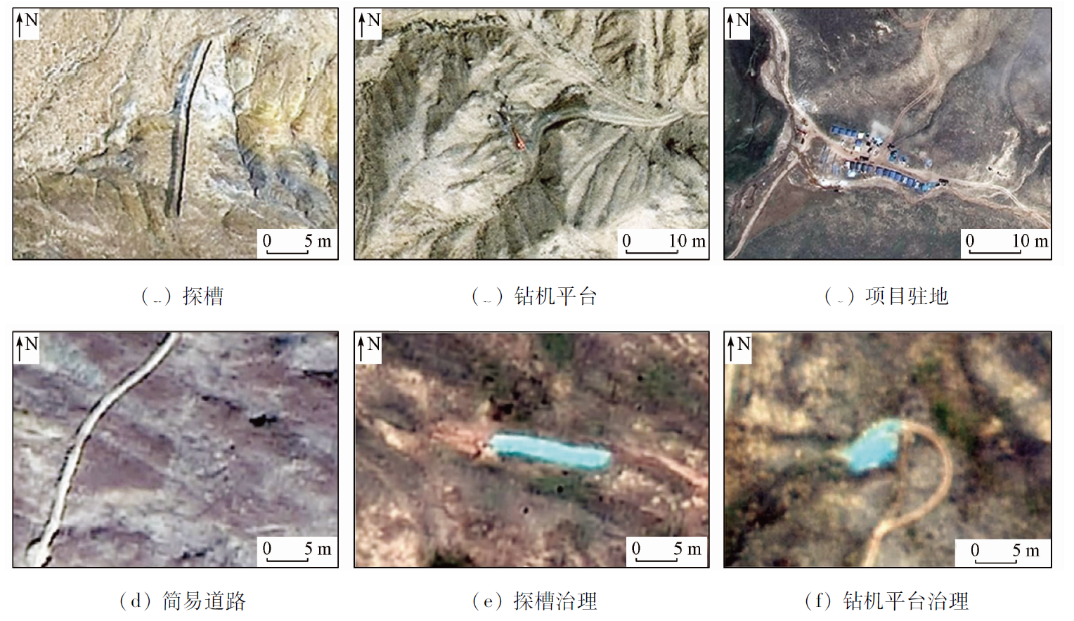
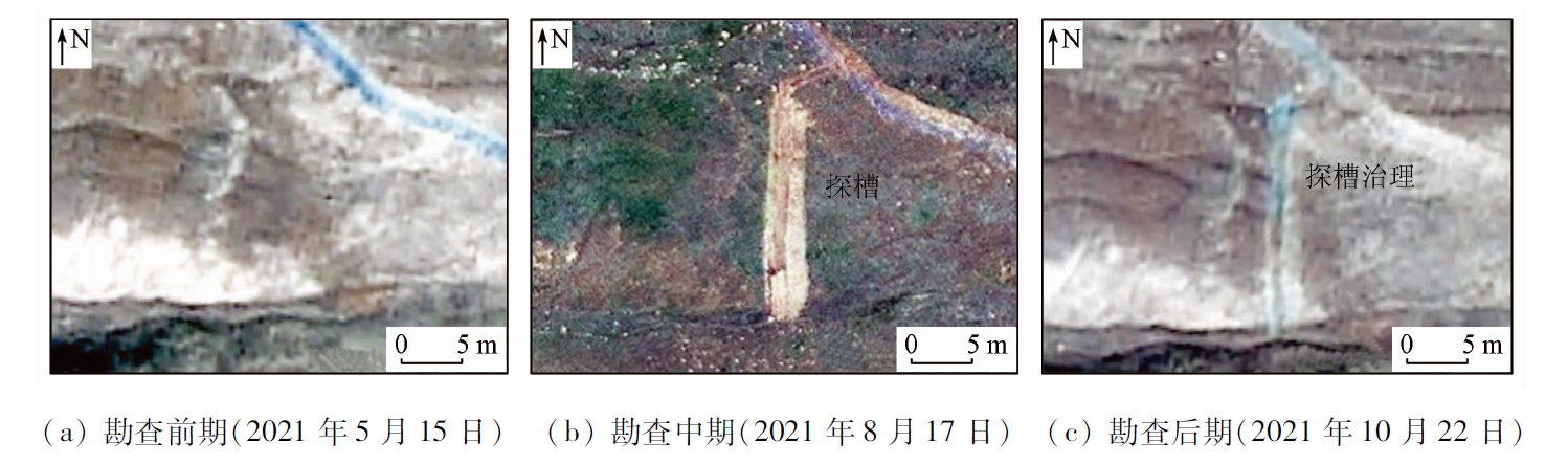
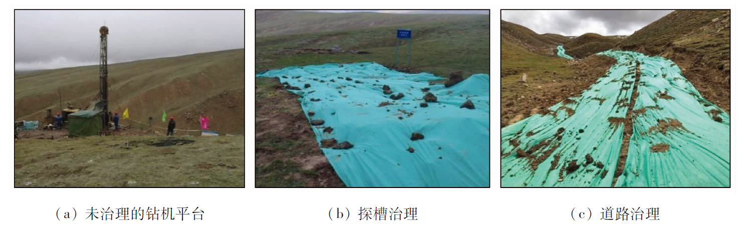
Resources serve as the material guarantee of the existence and development of human society. However, as a basis for resource discovery, geological exploration tends to damage the ecological environment. With the official release of the Specification for Green Geological Survey and Mineral Exploration (DZ/T 0374—2021) in June 2021, green geological exploration has been officially promoted to the national level and was implemented nationwide in China. However, the supervision of green geological exploration faces many difficulties and challenges in practice. To meet the demands of responsible entities for the supervision, inspection, and management of green geological exploration projects, this study proposed a high-efficiency supervision method based on remote sensing. By applying this method to a polymetallic survey project in Qinghai Province, this study expounded the specific implementation process of the method, as well as its effectiveness in the supervision services for geological exploration projects. As indicated by the results, the method proposed in this study allows for ascertaining the basic external environment of the project area, following the project layout and implementation, and verifying the consistency with the project plan. In addition, through quantitative information investigation, this method allows for the full identification of the disturbance and damage to the ecological environment and its restoration during the project implementation. Therefore, this study can provide effective technical support and basic data for evaluating the performance of green geological exploration.
马世斌, 皮英楠, 王佳, 张焜, 李生辉, 彭玺. 基于遥感的绿色勘查高效监管方法体系研究[J]. 自然资源遥感, 2023, 35(2): 255-263.
MA Shibin, PI Yingnan, WANG Jia, ZHANG Kun, LI Shenghui, PENG Xi. High-efficiency supervision method for green geological exploration based on remote sensing. Remote Sensing for Natural Resources, 2023, 35(2): 255-263.
Zhang Y. The Fifth Plenary Session of the 18th CPC Central Committee put forward five development concepts for the first time[N/OL]. Xinhuanet,2016-06-20. http://www.qunzh.com/pub/jsqzw/xxzt/jd95zn/jdll/sgqm/201606/t20160620_21716.html.
Announcement of the Ministry of natural resources on Issuing the industrial standard of the code for green geological exploration[EB/OL]. China Government Network, 2021-06-18[2021-06-22]. http://www.gov.cn/zhengce/zhengceku/2021-06/22/content_5620007.htm.
[5]
戴阳利, 龚燃. 国外商业航天发展情况分析[J]. 卫星应用, 2020(10):22-26.
Dai Y L, Gong R. Analysis of the development of foreign commercial aerospace[J]. Satellite Application, 2020(10):22-26.
[6]
毛凌野. 国内主要商业航天企业发展现状[J]. 卫星应用, 2017(10):28-32.
Mao L Y. Development status of major domestic commercial aerospace companies[J]. Satellite Application, 2017(10):28-32.
Integrated development of technology R & D knowledge service[N/OL]. Zhongdimedium,2020-01-19. https://zhidao.baidu.com/question/559271323356147972.html.
Zhao C. Study on coordinated development of geological and mineral exploration and ecological environment protection[J]. China Equipment Engineering, 2021(11)246-247.
He Z P, Zhao Q B, Li X R, et al. Thoughts and suggestions on promoting the standardization of geological exploration based on the concept of green development[J]. China Mining, 2021, 30(11):13-17.
Pang B. The construction of provincial satellite centers for natural resources has achieved full coverage[N/OL]. Website of the Ministry of Natural Resources,2020-09-11. http://www.gov.cn/xinwen/2020-09/11/content_5542544.htm.
Wang Y Z, Liu G, Guo L, et al. Research on ortho-rectification and true color synthesis technique of GF-1 WFV data in China-Pakistan Economic Corridor[J]. Remote Sensing for Land and Resources, 2020, 32(2):213-218.doi:10.6046/gtzyyg.2020.02.27.
doi: 10.6046/gtzyyg.2020.02.27
Ma S B, Yang W F, Zhang K. Study of key technology of SPOT6 satellite image processing[J]. Remote Sensing for Land and Resources, 2015, 27(3):30-35.doi:10.6046/gtzyyg.2015.03.06.
doi: 10.6046/gtzyyg.2015.03.06
Shi Y C, Ye H, Guo J, et al. The effect of geometric rectification modes on positioning accuracy for QuickBird panchromatic image:A case study of loess plateau[J]. Remote Sensing for Land and Resources, 2011, 23(3):135-139.doi:10.6046/gtzyyg.2011.03.24.
doi: 10.6046/gtzyyg.2011.03.24
Sun P, Dong Y S, Chen W T, et al. Research on fusion of GF-2 imagery and quality evaluation[J]. Remote Sensing for Land and Resources, 2016, 28(4):108-113.doi:10.6046/gtzyyg.2016.04.17.
doi: 10.6046/gtzyyg.2016.04.17
Xu B, Fang C. Data fusion methods of ZY-1 02C and ETM+ images and effect evaluation[J]. Remote Sensing for Land and Resources, 2014, 26(3):80-85.doi:10.6046/gtzyyg.2014.03.13.
doi: 10.6046/gtzyyg.2014.03.13
Wang H B, Li G Y, Zhang B K, et al. Contrast and analysis of different fusion algorithms for ZY-3 satellite images[J]. Science of Surveying and Mapping, 2015, 40(1):47-51.
Guo L, Yang J H, Shi L S, et al. Comparative study of image fusion algorithms for SPOT6[J]. Remote Sensing for Land and Resources, 2014, 26(4):71-77.doi:10.6046/gtzyyg.2014.04.12.
doi: 10.6046/gtzyyg.2014.04.12
Chu Y, Shan J K, Hou J G. Comparison and analysis of the fusion results of GeoEye-1 remote sensing imagery[J]. Geomatics and Spatial Information Technology, 2011, 34(3):21-26.
Liu D W, Han L, Han X Y. Research on high resolution remote sensing image classification based on deep learning[J]. Journal of Optics, 2016(4):306-314.
Feng L Y. Research on construction land information extraction from high-resolution remote sensing images based on deep learning technology[D]. Hangzhou: Zhejiang University, 2017.
[23]
王小娜, 田金炎, 李小娟, 等. Google Earth Engine云平台对遥感发展的改变[J]. 遥感学报, 2022, 26(2):299-309.
Wang X N, Tian J Y, Li X J, et al. Benefits of Google Earth Engine in remote sensing[J]. National Remote Sensing Bulletin, 2022, 26(2):299-309.
doi: 10.11834/jrs.20211317
Fu D J, Xiao H, Su F Z, et al. Remote sensing cloud computing platform development and earth science application[J]. National Remote Sensing Bulletin, 2021, 25(1):220-230.
doi: 10.11834/jrs.20210447
 2023, Vol. 35
  ), 皮英楠1,2,3(