Paleodrainage network in the Xiong’an New Area: Remote sensing-based reconstruction and relationship with town planning
SUN Xiyong1,3(), LI Jingjing2(), ZHANG Ruijiang1, WANG Shaoqiang3,4, JI Xinyang1, LI Guangwei1
1. China Aero Geophysical Survey and Remote Sensing Center for Natural Resources, Beijing 100083, China 2. China University of Geosciences(Beijing), Beijing 100083, China 3. China University of Geosciences (Wuhan), Wuhan 430074,China 4. Institute of Geographic Sciences and Natural Resources Research, Beijing 100101, China
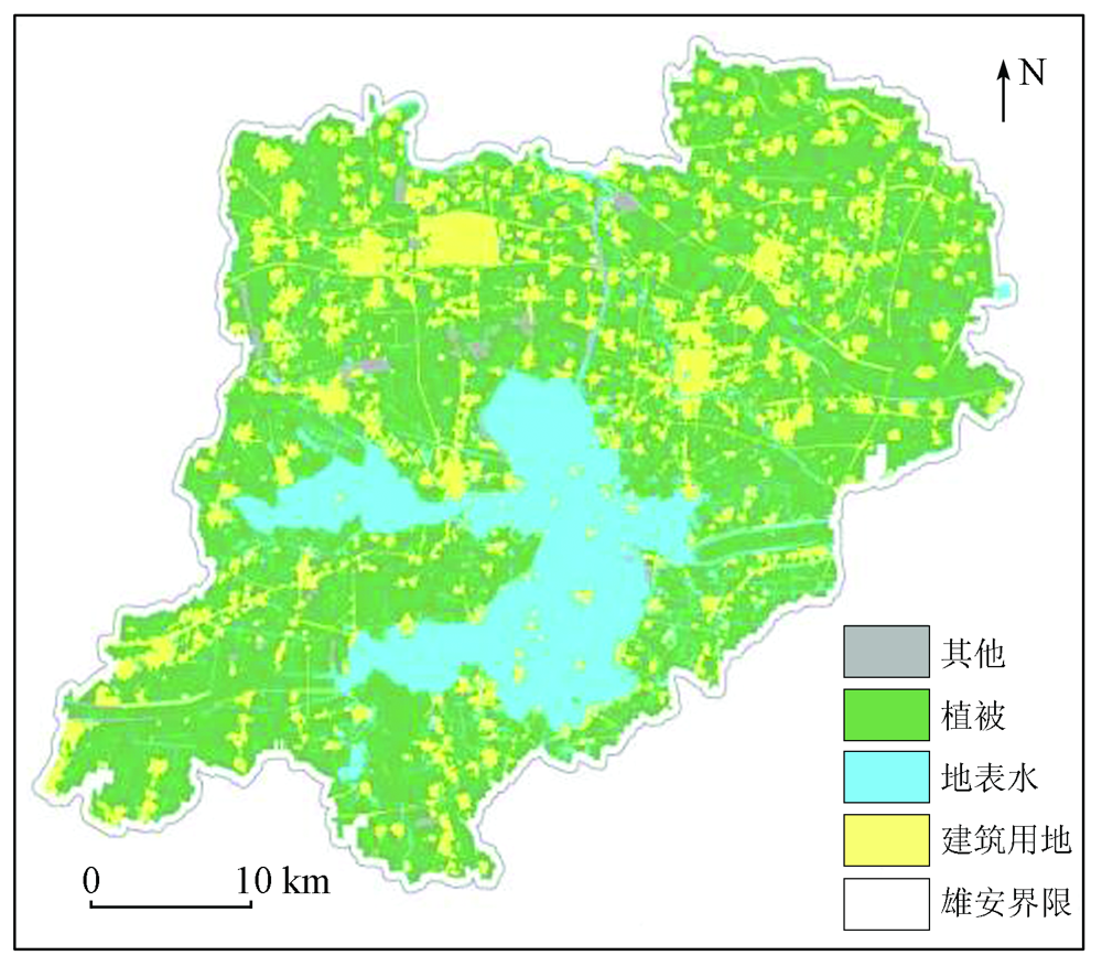
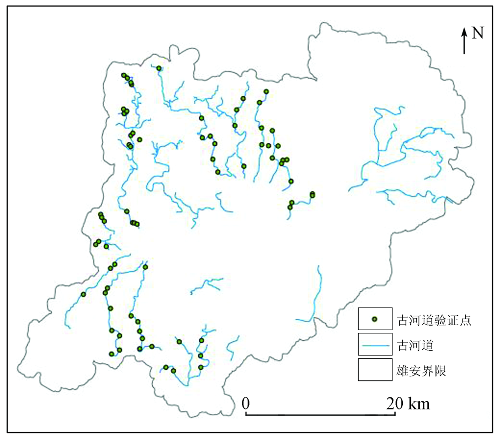
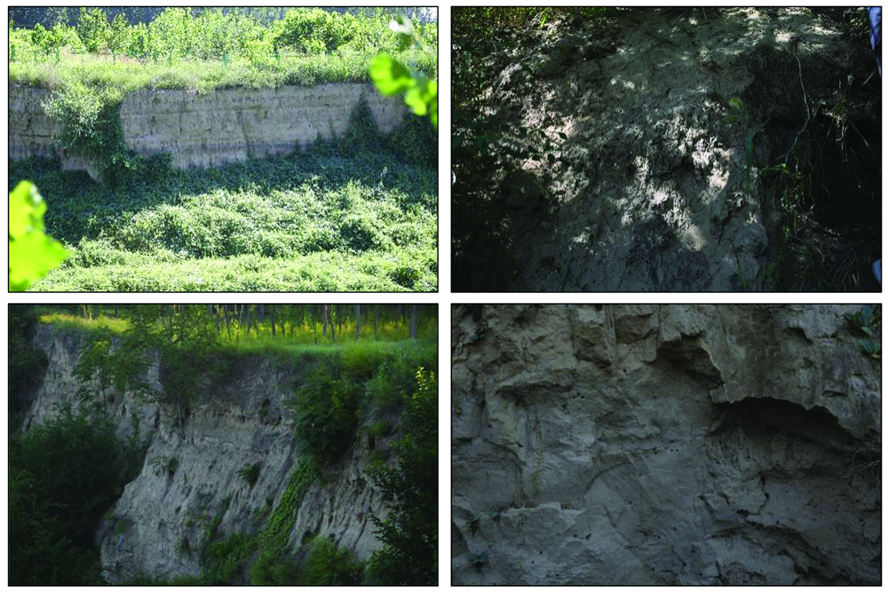
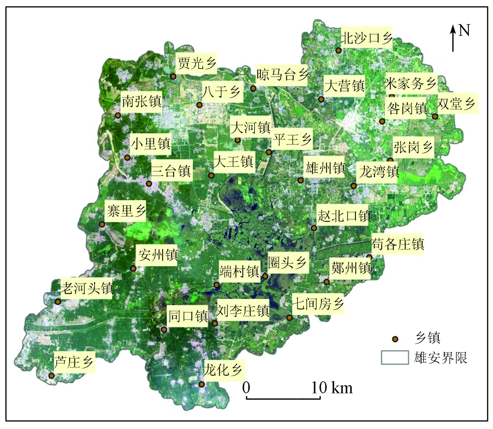
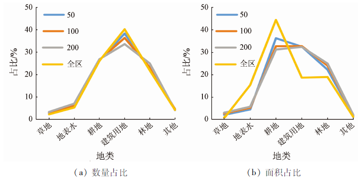
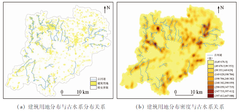
Xiong’an New Area is a national new area. It has a low groundwater level and close water exchange between the zone of aeration and the saturated zone, with the upward recharge of groundwater increasing the water content in soil. On this basis, with remote sensing images as the data source, this study carried out object-oriented land classification for the study area, extracted the vegetation information by mask, and further extracted the soil moisture information of the vegetation area using the temperature vegetation dryness index (TVDI). Then, by combining the geological and geomorphic characteristics of the palaeochannels in the area, as well as visual interpretation, this study identified the palaeochannels in the study area and verified them in the field. Finally, it reconstructed the paleodrainage system of the study area. The results are as follows: ① The method proposed in this study can effectively extract information on the paleodrainage system in the study area; ② The distribution of the current surface water bodies in the study area is quite different from that of the paleodrainage system; ③ The comparison between the land classification results and the paleodrainage system interpretation results shows that the paleodrainage system was mostly distributed in present construction land, which is present as rural residential areas in remote sensing images. 50 m, 100 m, and 200 m buffer zones were set in the paleodrainage system areas, and then a intersection analysis was made for the buffer zones and the land classification results. The results show that the proportion of construction land in the buffer zones is significantly higher than that of construction land in the whole region. This result indicates that there exists a certain correlation between the distribution of the paleodrainage system and villages.
孙禧勇, 李晶晶, 张瑞江, 王绍强, 冀欣阳, 李光玮. 基于遥感的雄安新区古水系网重构与城镇规划关系研究[J]. 自然资源遥感, 2023, 35(1): 132-139.
SUN Xiyong, LI Jingjing, ZHANG Ruijiang, WANG Shaoqiang, JI Xinyang, LI Guangwei. Paleodrainage network in the Xiong’an New Area: Remote sensing-based reconstruction and relationship with town planning. Remote Sensing for Natural Resources, 2023, 35(1): 132-139.
Zhao Y X, Xu Q H, Liu F Q, et al. Progresses of palaeochannel studies in China in the past 20 years[J]. Progress in geographical science, 2013, 32(1):3-19.
Wang J, Li J C, Zhang D. Identification of ancient river channels based on multi-source remote sensing data——Take the ancient Yellow River channel in Dengkou Area as an example[J]. Journal of Capital Normal University (Natural Science Edition), 2019, 40(1):70-77.
Yu C C, Qiao R X, Zhang D S. Three dimensional basement structural characteristics inferred by aeromagnetic in Xiong’an New Area[J]. Geophysical and Geochemical Exploration, 2017, 41(3):385-391.
Sun X Y, Miao J, Yu H, et al. Analysis of urban expansion in Xiong’an New Area in recent 40 years based on multi-source remote sensing data[J]. Innovative Technology, 2018, 18 (2):22-26.
Lv X, Chen L, Han F, et al. Muwen River in Laiwu City uses ancient water system to build plain reservoir project[J]. China Water Transportation, 2011, 11 (8):188-189.
[8]
Almulla S T, Albadran B N, Al-Ali A. Application of remote sensing techniques to map the paleochannels of Shatt Al-Arab and Khor Al-Zubair,southern Iraq[J]. Marsh Bulletin, 2011, 6(1):23-31.
Zhang F T. Display characteristics of Yongding River alluvial fan and ancient channel on satellite image[J]. Hydrogeology and Engineering Geology, 1986(1):54-53.
[10]
Samadder R K, Kumar S, Gupta R P. Paleochannels and their potential for artificial groundwater recharge in the western Ganga plains[J]. Journal of Hydrology, 2011, 400(1-2):154-164.
doi: 10.1016/j.jhydrol.2011.01.039
Zhang J, Ma Z, Wu A M, et al. Recognition of surface paleodrainage system in Xiong’an New Area based on lithologic spectral characteristics[J]. Acta Geosciences, 2018, 39(5):542-548.
Qin L, Zhan H M, Song X J, et al. Analysis of shallow buried ancient water system in Jinghai County based on remote sensing technology[J]. Geological Survey and Research, 2008, 31(4):321-327.
Wu A Q, Liu C Y. Bridge architectural characteristics and influence of Tokyo City in the Northern Song Dynasty[J]. Journal of Henan University (Social Science Edition), 2002(3):63-67.
Gao C, Wang X Y, Jin G J, et al. Spatial distribution features of archaeological sites (Neolithic Age to Shang & Zhou Dynasties) on the western shore of the Chaohu Lake,China[J]. Geographical Research, 2009, 28(4):979-989.
Wang K L, Li H T, Wu A M, et al. Study on the evolution of Baiyangdian Wetland under artificial water replenishment[J]. Acta Geosciences, 2018, 39(5):40-49.
[16]
周莹. 雄安新区4万年以来古环境演化研究[D]. 北京: 中国地质大学(北京), 2020.
Zhou Y. Study on the evolution of Paleoenvironment in Xiong’an New Area since 40000 years[D]. Beijing: China University of Geosciences (Beijing), 2020.
Wu C, Zhu X Q, He N H, et al. Study on the formation of ancient river channels in North China Plain[J]. Science of China (Part B,Chemistry,Life Sciences and Geosciences), 1991(2):188-197.
Yan H B, Zhou G Q. Research progress of optical remote sensing inversion methods for surface soil moisture[J]. Journal of Subtropical Resources and Environment, 2017, 12(2):82-89,95.
Tan Q L, Liu Z J, Shen W. An object-oriented multi-scale segmentation method for remote sensing images[J]. Journal of Beijing Jiaotong University, 2007(4):111-114,119.
[20]
王杰. 基于面向对象分类和CNN的土地覆盖遥感提取[D]. 合肥: 安徽大学, 2020.
Wang J. Remote sensing extraction of land cover based on object-oriented classification and CNN[D]. Hefei: Anhui University, 2020.
Fan L S, Jiang J H, Sheng H, et al. Inversion of soil moisture during summer drought in Hangzhou by temperature vegetation drought index (TVDI)[J]. China Agrometeorology, 2009, 30(2):230-234.
[23]
方旭辉. 大清河水系变迁及其对雄安新区建设的影响[D]. 保定: 河北农业大学, 2019.
Fang X H. Changes of Daqing River system and its impact on the construction of Xiong’an New Area[D]. Baoding: Hebei Agricultural University, 2019.
Mao X, Liu L J, Song L, et al. Evolution process and influencing factors of ecological environment in Baiyangdian in recent 70 years[J]. Earth science, 2021, 46(7):2609-2620.
Sun X Y, Xu W, Jiang D C, et al. Study on temporal change of surface water and regional planning in Xiong’an New Area based on remote sensing[J]. Advances in geophysics, 2021, 36(4):1443-1455.
 2023, Vol. 35
  ), 李晶晶2(