Assessing intensive urban land use based on remote sensing images and industry survey data
WANG Haiwen1,2,3(), JIA Junqing2, LI Beichen2, DONG Yongping4, HA Sier4
1. School of Geography Science, Inner Mongolia Normal University, Hohhot 010010, China 2. Inner Mongolia Land and Space Planning Institute, Hohhot 010010, China 3. Inner Mongolia Autonomous Region Land Use and Renovation Engineering Technology Research Center, Hohhot 010010, China 4. Xi’an Changlin Fengcao Ecological Technology Co., Ltd., Xi’an 710000, China
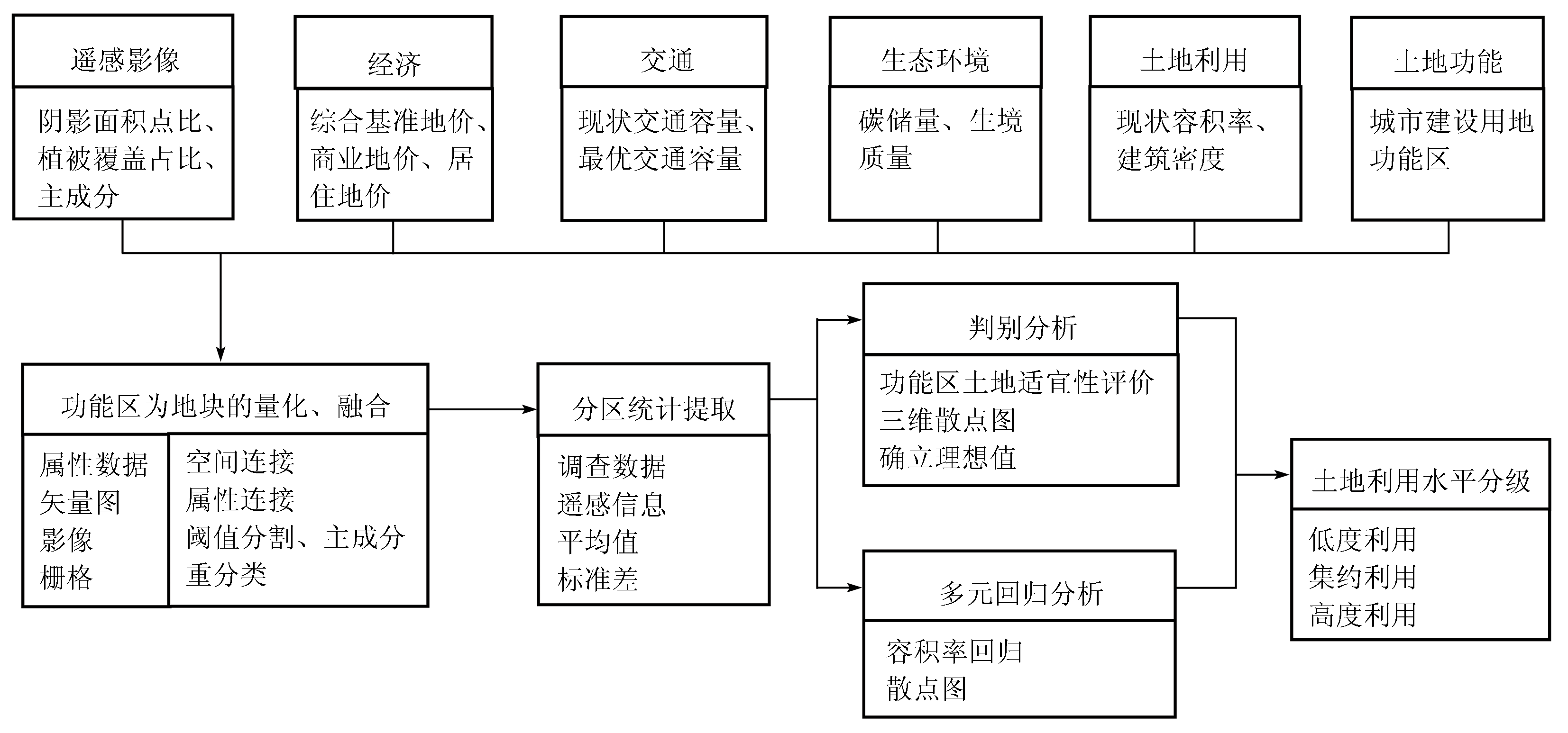
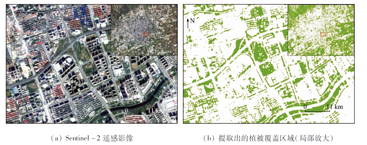
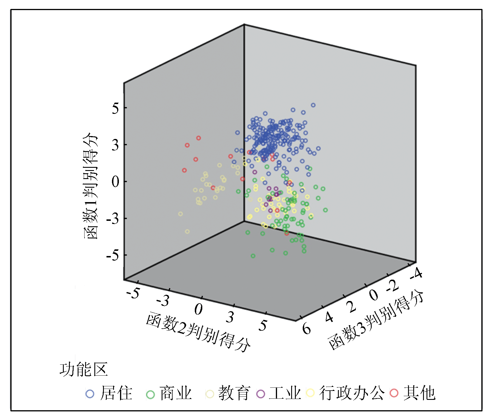
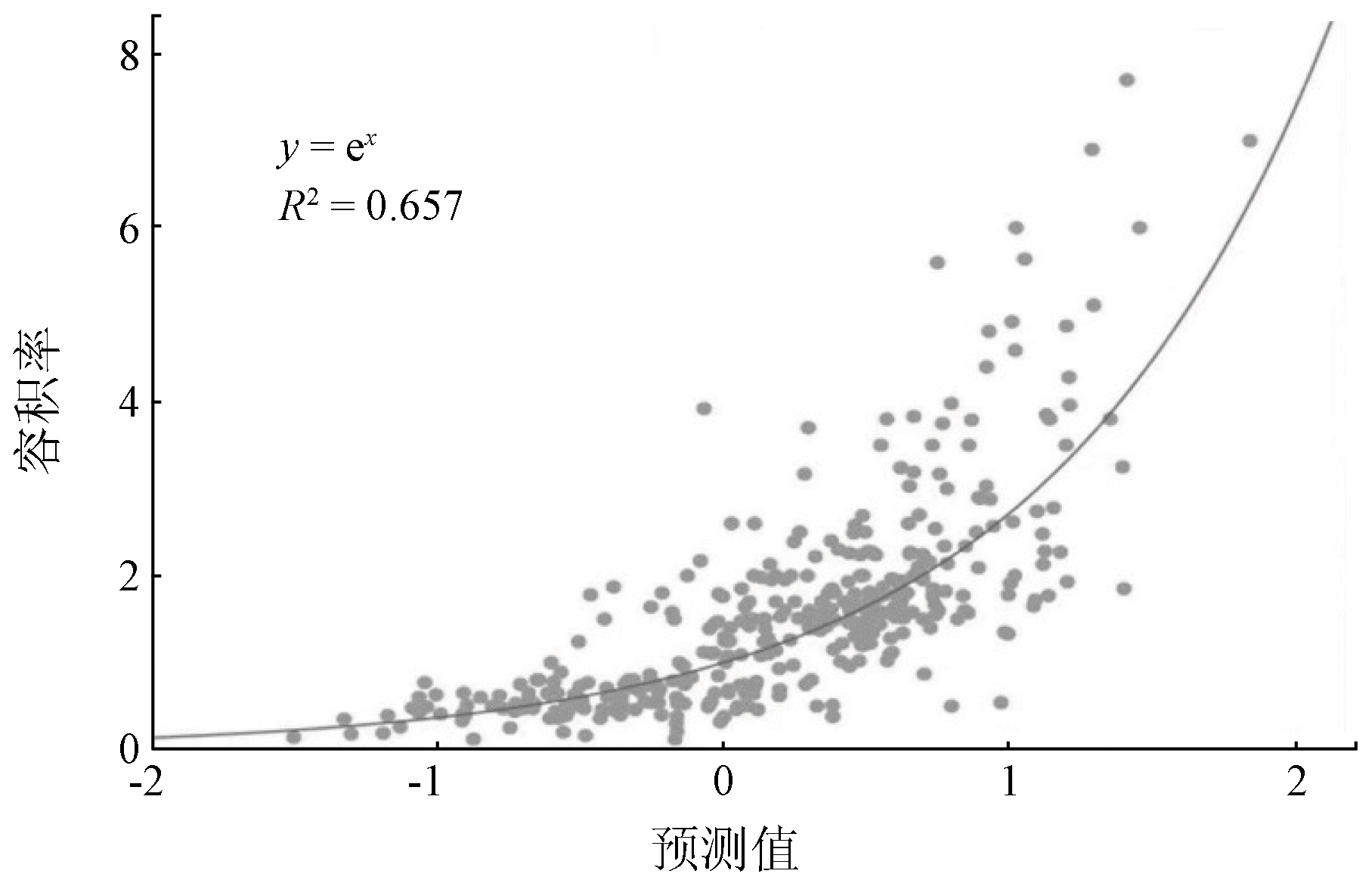
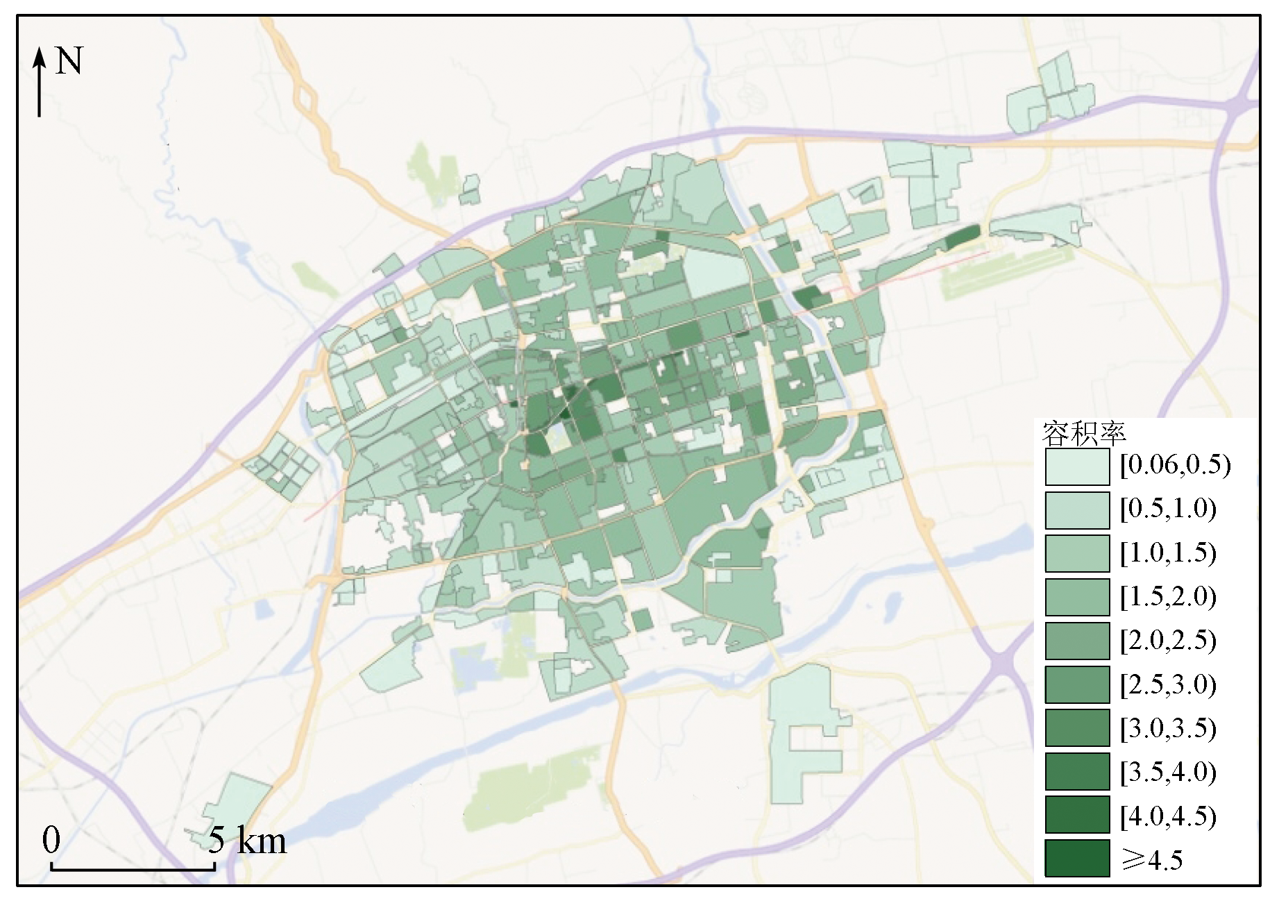
To scientifically evaluate the land suitability of urban functional areas and to accurately assess the intensive urban land use (IULU) in Hohhot City, this study built an indicator system by integrating the industry survey data and the features extracted from remote sensing images. Then, it assessed the urban function zoning and the IULU in Hohhot through quantification and integration based on land. The results show that 93.0% of the functional areas share common multivariate quantitative characteristics, indicating suitable functional orientation and land use. Moreover, this study built a high-precision multivariate regression model using remote sensing factors (i.e., the principal components of images and the proportions of the shadow and vegetation areas) and survey data (i.e., carbon stock, building density, and the land prices of residential and commercial functional areas). Then, the floor area ratio was calculated based on the model, thus achieving the quantitative assessment of the IULU. The results of this study show that the assessment of IULU based on remote sensing images and industry survey data is feasible and has value in popularization and applications.
王海雯, 贾俊青, 李北辰, 董永平, 哈斯尔. 基于遥感和行业调查数据的城市土地集约利用水平评估[J]. 自然资源遥感, 2023, 35(2): 149-156.
WANG Haiwen, JIA Junqing, LI Beichen, DONG Yongping, HA Sier. Assessing intensive urban land use based on remote sensing images and industry survey data. Remote Sensing for Natural Resources, 2023, 35(2): 149-156.
Huang L X. A study from the macroeconomic regulation perspective on the spatial-temporal change character of land supply economic system and the land policy performance evaluation[J]. Contemporary Economic Management, 2015, 37(4):74-78.
Chu L. The evaluation of urban land intensive utilization based on two methods:Take Zhengzhou City as an example[D]. Beijing: China University of Geosciences (Beijing), 2021.
Liang L T, Fan P F. Evaluation of urban land intensive use and diagnosis of obstacle factors based on ecological health and low-carbon development[C]// Chima Land Society.2015 Cross-Strait Land Academic Exchange Conference, 2015,79-88.
Deng L Y, Yin C L. Rational setting down floor area ratio under the guidance of scientific development view[J]. Shanxi Architecture, 2006, 32(20):53-55.
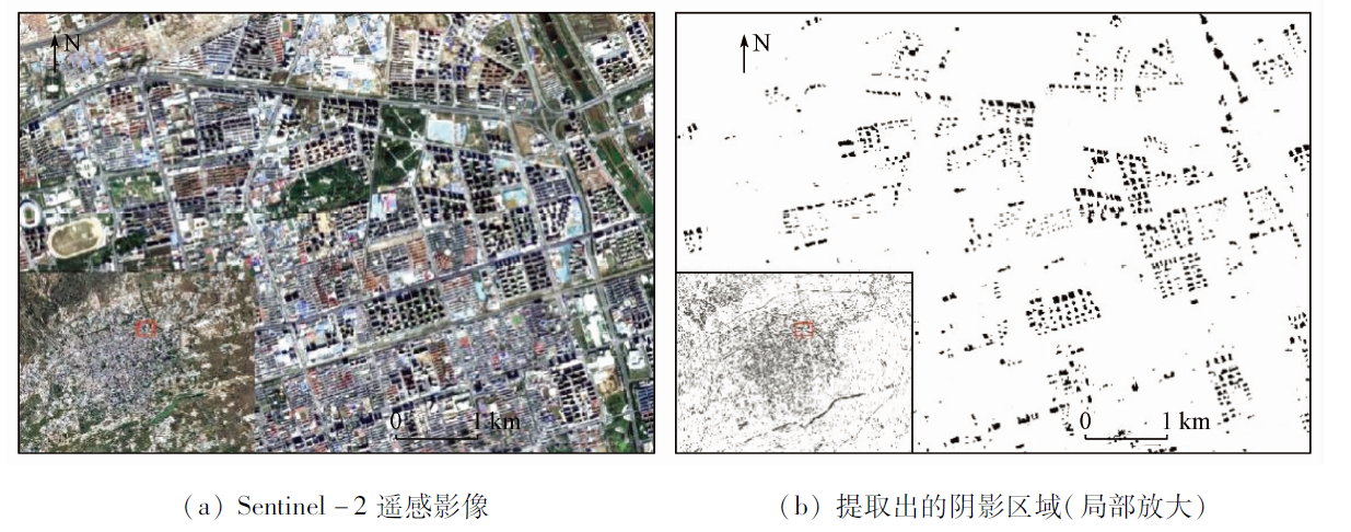
Liu X Z, Zhou S L, Li Z Y. Extraction of building shadows from urban high resolution remote sensing image[J]. Computer Simulation, 2008, 25(8):197-200.
Liiu H H, Zeng Z P. Impacts of east lake scenic area in Wuhan on values of adjoining residential property[J]. Resource Development & Market, 2013, 29(6):585-589.
Qin T. The relation of the city traffic network and the land prices based on the space syntax:For Xuzhou[J]. Journal of Capital Normal University (Natural Science Edition), 2010, 31(1):55 -59.
Liu H H. Research on the influence of lake landscape in Wuhan to the values of adjoining residential property based on HPM and GIS[D]. Wuhan: Huazhong University of Science & Technology, 2013.
Yin J, Xie J Q, Wang L, et al. The evaluation of urban land intensive use based on RS[J]. Journal of Natural Resources, 2007, 22(5):775-782.
doi: 10.11849/zrzyxb.2007.05.012
Wang L, Niu Z, Yin J, et al. Potential evaluation of land intensive use in metropolis based on RS and ANN[J]. Journal of Chongqing Jianzhu University, 2007, 29(3):32-35.
Li X P. Urban traffic congestion countermeasures:Opening research of enclosed type district traffic[D]. Changsha: Changsha University of Science & Technology, 2014.
Wu R Y. Study on land ecological security evaluation in DongSheng district:The typical area of energy development in central and western region of Inner Mongolia[D]. Hohhot: Inner Mongolia Normal University, 2018.
Wu S, Jiang Q G. Evaluation of intensive land use in the small city based on RS and GIS[J]. China Population,Resources and Environment, 2015, 25(s1):53-57.
An Y M, Zhao W W, Jiang G H, et al. Study on urban land grading based on the MAPGIS land price system:Taking the commercial land in Dezhou City for example[J]. Chinese Agricultural Science Bulletin, 2013(23):51-58.
Nin Y, Zhou Y, Yu J, et al. Gradation of agricultural land based on GIS and the fuzzy-material analysis method[J]. Transactions of the Chinese Society of Agricultural Engineering, 2004, 20(5):297-300.
[25]
李龙华. 基于GIS的石泉县城镇土地基准地价评估研究[D]. 西安: 长安大学, 2015.
Li L H. Study on the assessment of Shiquan County town benchmark land price based on GIS[D]. Xi’an: Chang’an University, 2015.
[26]
盛艳蕊. 基于GIS的城镇土地定级和标定地价的研究[D]. 合肥: 合肥工业大学, 2007.
Sheng Y R. Study of urban land grading and demarcated land price based on GIS[D]. Hefei: Hefei University of Technology, 2007.
Gao L. Studies on the grade of cities land and the update of the datum land prices based on the GIS:A case of Zhoucun, Zibo City[D]. Taian: Shandong Agricultural University, 2013.
Sun Y M, Zhang B G, Wu Q Z, et al. Application of domestic low-cost micro-satellite images in urban bare land identification[J]. Remote Sensing for Natural Resources, 2022, 34(1):189-197.doi:10.6046/zrzyyg.2021056.
doi: 10.6046/zrzyyg.2021056
Wu L L, Li X Y, Mao D H, et al. Urban land use classification based on remote sensing and multi-source geographic data[J]. Remote Sensing for Natural Resources, 2022, 34(1):127-134.doi:10.6046/zrzyyg.2021061.
doi: 10.6046/zrzyyg.2021061
 2023, Vol. 35
  ), 贾俊青2, 李北辰2, 董永平4, 哈斯尔4