Application of GF-5 hyperspectral data in uranium deposit exploration
ZHANG Yuantao1,2(), PAN Wei1, YU Changfa1
1. National Key Laboratory of Remote Sensing Information and Image Analysis Technology, Beijing Research Institute of Uranium Geology, Beijing 100029, China 2. No.280 Institute of Nuclear Industry, Deyang 618300, China
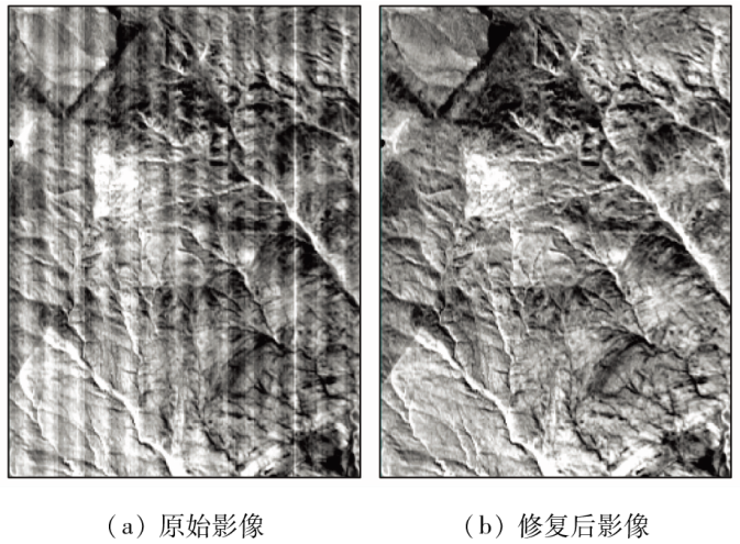
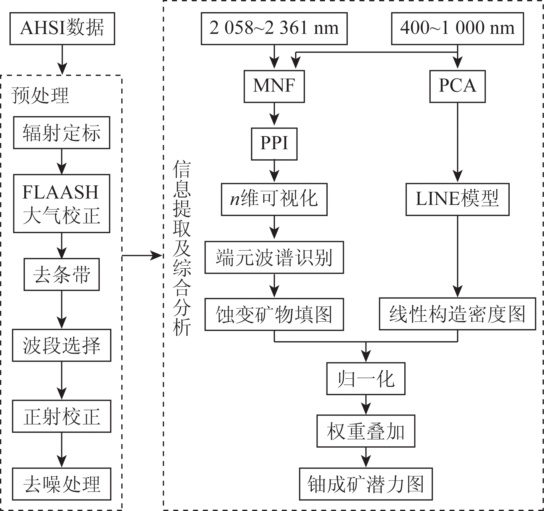
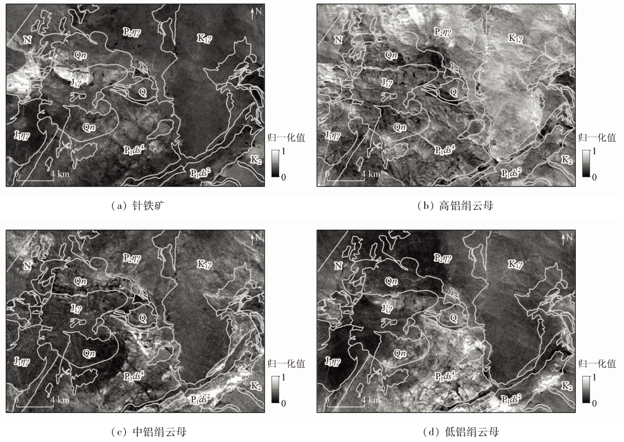
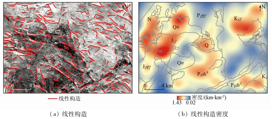
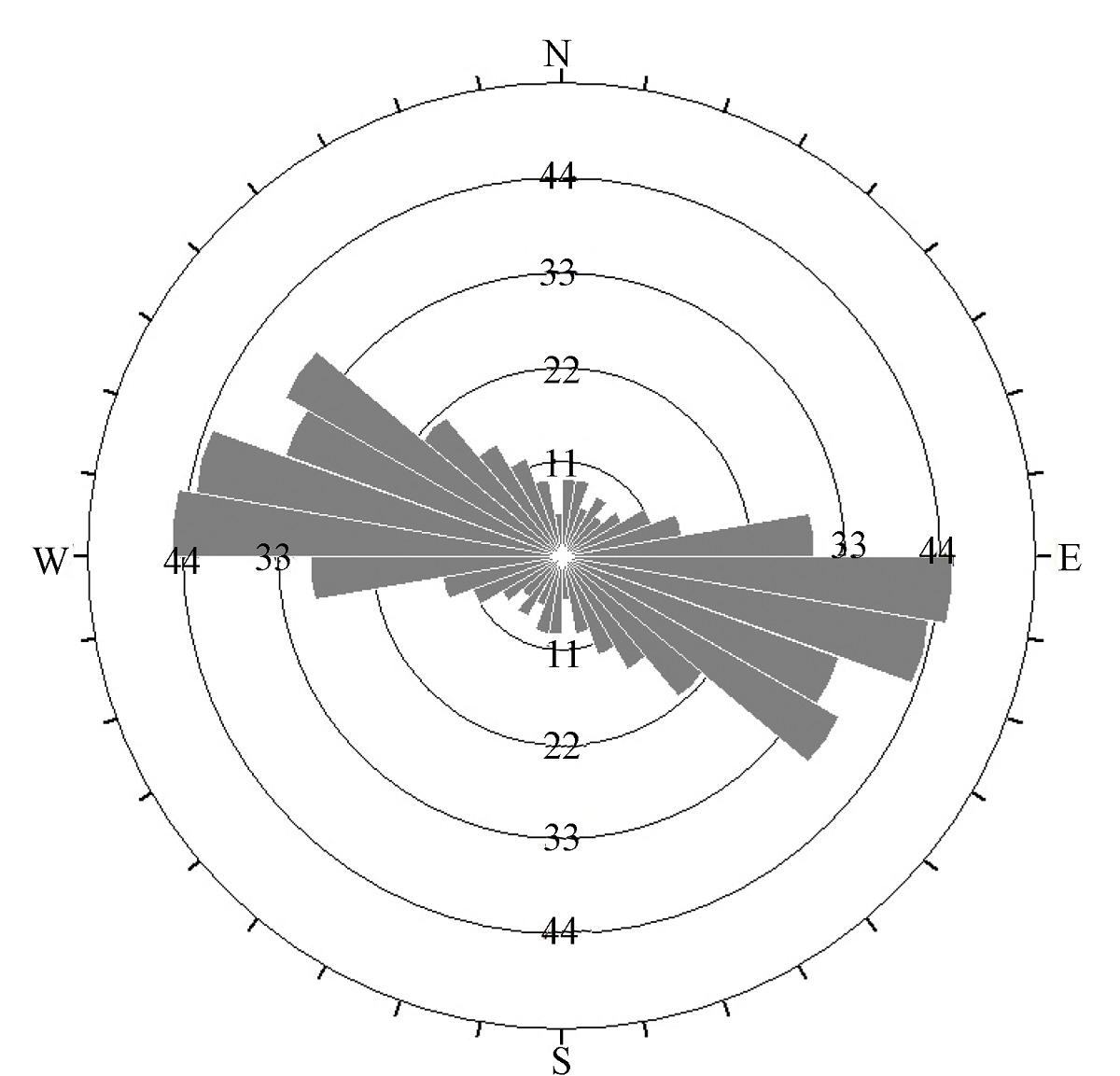
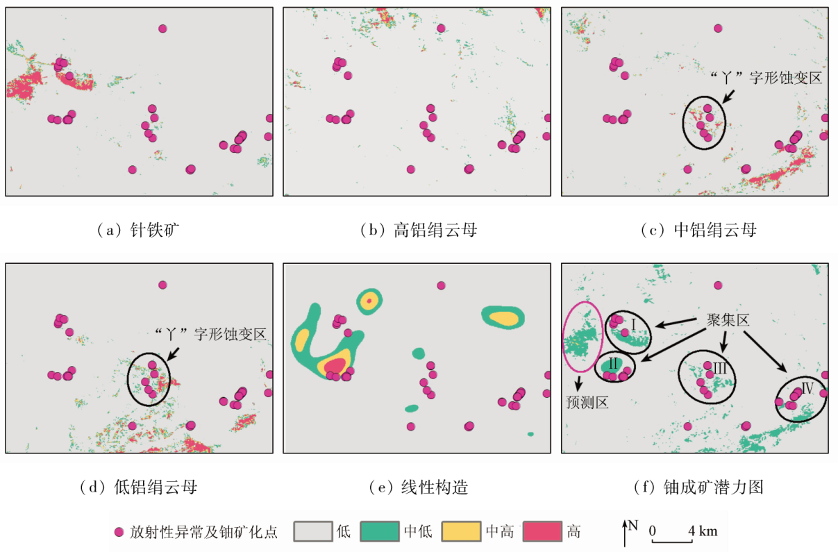
However, since GF-5 launch in 2018, few studies regarding the application of GF-5 AHSI data for uranium deposit exploration have been reported. In this study, with the Weijing area of Inner Mongolia as the study area, the spectral hourglass technology was applied to extract alteration anomalies of goethite and low-, medium-, and high-aluminum sericite from corresponding GF-5 AHSI data. Then, the principal component analysis (PCA) and the LINE module in PCI Geomatica software were employed for the automatic extraction of linear structures in the study area, with a linear structure density map created. Finally, a uranium mineralization potential map of the study area was generated by integrating all proof layers based on the ArcGIS software. The results indicate that the extraction of alteration information and linear structures, and the integration of multiple proof layers are feasible, and the obtained uranium mineralization potential map exhibits high reliability. One uranium deposit prediction zone was identified based on the study results and geological data. The study results will guide the subsequent uranium deposit exploration in the study area while providing a reference for the geological application of GF-5 AHSI data.
Ye F W, Meng S, Zhang C, et al. Identification of alkali-metasomatism type alteration associated with uranium mineralization using airborne hyperspectral in Jiling uranium deposit in Longshoushan area,Gansu Province[J]. Journal of Geo-Information Science, 2019, 21(2):279-292.
Li N, Gan F P, Dong X F, et al. Preliminary application and evaluation of GF-5 satellite hyperspectral data in lithology-structure interpretation[J]. Aerospace Shanghai, 2019, 36(s2):187-191,198.
[4]
Ye B, Tian S F, Cheng Q M, et al. Application of lithological mapping based on advanced hyperspectral imager (AHSI) imagery onboard Gaofen-5 (GF-5) satellite[J]. Remote Sensing, 2020, 12(23):3990.
doi: 10.3390/rs12233990
Lian C Q, Yao F J, Chen M H, et al. The study on alteration information extraction of GF-5 hyperspectral data in vegetation coverage area:A case study of the Yushui copper deposit in Guangdong Province[J]. Geoscience, 2020, 34(4):680-686.
Sun Y, Liu J J, Zhao Y J, et al. Alteration mineral mapping based on the GF-5 hyperspectral data and its geological application:An example of the Huaniushan area in Guazhou County of Gansu Province[J]. Geology in China, 2022, 49(2):558-574.
Wang Q, Ren G L. Application of hyperspectral remote sensing data-based anomaly extraction in copper-gold prospecting in the Solake area in the Altyn metallogenic belt,Xinjiang[J]. Remote Sensing for Natural Resources, 2022, 34(1):277-285.doi:10.6046/zrzyyg.2021036.
Zhang C, Ye F W, Xu Q J, et al. Mineral mapping and analysis of alteration characteristics using airborne hyperspectral remote sensing data in the Baiyanghe uranium and beryllium ore district,Xinjiang[J]. Remote Sensing for Land and Resources, 2017, 29(2):160-166.doi:10.6046/gtzyyg.2017.02.23.
[10]
Kumar C, Chatterjee S, Oommen T, et al. Automated lithological mapping by integrating spectral enhancement techniques and machine learning algorithms using AVIRIS-NG hyperspectral data in Gold-bearing granite-greenstone rocks in Hutti,India[J]. International Journal of Applied Earth Observation and Geoinformation, 2020, 86:102006.
doi: 10.1016/j.jag.2019.102006
Yu C F, Zhang Y T. Uranium prospecting in Weijing area of Inner Mongolia[J]. Science Technology and Engineering, 2020, 20(33):13575-13582.
[12]
Wan L, Lin Y, Zhang H, et al. GF-5 hyperspectral data for species mapping of mangrove in Mai Po,Hong Kong[J]. Remote Sensing, 2020, 12(4):656.
doi: 10.3390/rs12040656
Sun Y B, Wang R J, Wei B Z, et al. The application of hyperspectral remote sensing ground-air integrated prediction method to the copper gold deposit prospecting in Kalatag area,Xinjiang[J]. Geology in China, 2018, 45(1):178-191.
Tan B X, Li Z Y, Chen E X, et al. Preprocessing of EO-1 Hyperion hyperspectral data[J]. Remote Sensing Information, 2005, 20(6):36-41.
[15]
Van der Meer F D, Van der Werff H M A, Van Ruitenbeek F J A, et al. Multi-and hyperspectral geologic remote sensing:A review[J]. International Journal of Applied Earth Observation and Geoinformation, 2012, 14(1):112-128.
doi: 10.1016/j.jag.2011.08.002
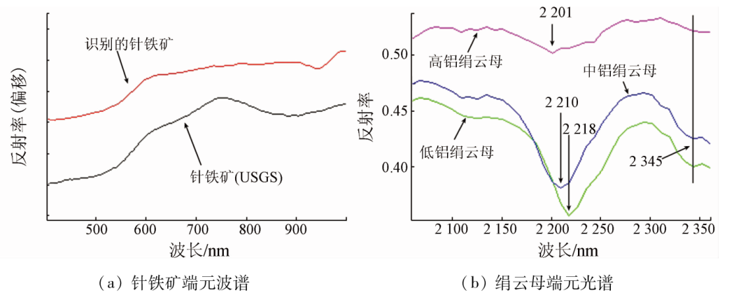
Ye F W, Meng S, Zhang C, et al. Minerageny study of high-Al,medium-Al and low-Al sericites identified by airborne hyperspectral remote sensing technology[J]. Acta Geologica Sinica, 2018, 92(2):395-412.
Gan F P, Wang R S, Ma A N. Spectral identification tree(sit)for mineral extraction based on spectral characteristics of minerals[J]. Earth Science Frontiers, 2003, 10(2):445-454.
Yan B K, Dong X F, Wang Z, et al. Mineral information extraction technology by airborne hyperspectral remote sensing and its application progress:An example of mineralization belts of Western China[J]. Geological Survey of China, 2016, 3(4):55-62.
Sun Y, Nie J T, Tian F, et al. Alteration mineral mapping of the Xiangshan uranium core using HySpex imaging hyperspectral data and its geological significance[J]. Geology and Exploration, 2015, 51(1):165-174.
[20]
Tripathi M K, Govil H. Evaluation of AVIRIS-NG hyperspectral images for mineral identification and mapping[J]. Heliyon, 2019, 5(11):e02931.
doi: 10.1016/j.heliyon.2019.e02931
Liang S N, Gan F P, Yan B K, et al. Relationship between composition and spectral feature of muscovite[J]. Remote Sensing for Land and Resources, 2012, 24(3):111-115.doi:10.6046/gtzyyg.2012.03.20.
Zhang C, Ye F W, Wang J G, et al. Spectral characteristics analysis of drill core in the Xiangyangping uranium deposit in the middle Miaoershan mountain,northeastern Guangxi[J]. Uranium Geology, 2019, 35(6):366-372.
[23]
Guha A. Mineral exploration using hyperspectral data[M]. Hyperspectral Remote Sensing.Elsevier, 2020:293-318.
[24]
Salehi T, Tangestani M H. Large-scale mapping of iron oxide and hydroxide minerals of Zefreh porphyry copper deposit,using Worldview-3 VNIR data in the Northeastern Isfahan,Iran[J]. International Journal of Applied Earth Observation and Geoinformation, 2018, 73:156-169.
doi: 10.1016/j.jag.2018.06.010
[25]
Hobbs W H. Lineaments of the Atlantic border region[J]. Geological Society of America Bulletin, 1904, 15: 483-506.
doi: 10.1130/GSAB-15-483
Jia S S, Wang E D, Fu J F, et al. Automatic extraction and ore-forming favorability analysis of linear form in remote sensing image of molybdenum polymetallic deposit in Liaoxi area[J]. Remote Sensing Technology and Application, 2009, 24(3):320-324,253.
Duan J B, Peng P, Yang Z, et al. Prediction of polymetallic metallogenic favorable area based on ASTER data[J]. Remote Sensing for Land and Resources, 2019, 31(3):193-200.doi:10.6046/gtzyyg.2019.03.24.
[28]
Adiri Z, El Harti A, Jellouli A, et al. Comparison of Landsat-8,ASTER and Sentinel 1 satellite remote sensing data in automatic lineaments extraction:A case study of Sidi Flah-Bouskour inlier,Moroccan Anti Atlas[J]. Advances in Space Research, 2017, 60(11):2355-2367.
doi: 10.1016/j.asr.2017.09.006
[29]
Javhar A, Chen X, Bao A, et al. Comparison of multi-resolution optical Landsat-8,Sentinel-2 and Radar Sentinel-1 data for automatic lineament extraction:A case study of Alichur area,SE Pamir[J]. Remote Sensing, 2019, 11(7):1-29.
doi: 10.3390/rs11010001
[30]
Forson E D, Menyeh A, Wemegah D D. Mapping lithological units,structural lineaments and alteration zones in the Southern Kibi-Winneba belt of Ghana using integrated geophysical and remote sensing datasets[J]. Ore Geology Reviews, 2021, 137:104271.
doi: 10.1016/j.oregeorev.2021.104271
Chen J P, Chen Y, Wang Q M. Study on synthetic informational mineral resource prediction using GIS:A case study in Chifeng region,Inner Mongolia,China[J]. Earth Science Frontiers, 2008, 15(4):18-26.
doi: 10.1016/S1872-5791(08)60035-4
Zhang Y T, Yu C F, Pan W, et al. Application of WorldView-3 and ASTER TIR for the exploration of uranium in Weijing,Inner Mongolia[J]. Uranium Geology, 2020, 36(5):408-417.
Yu C F, Pan W, Zhang Y T, et al. Application of remote sensing technique to uranium exploration in Sumoqagan Obo District,Inner Mongolia[J]. Uranium Geology, 2018, 34(6):372-378.
Zhang Y T, Pan W, Yu C F, et al. Application of WorldView-3 image in uranium exploration in Sumoqagan Obo,Inner Mongolia[J]. Uranium Geology, 2019, 35(2):114-121.
 2023, Vol. 35
  ), 潘蔚1, 余长发1