Net primary productivity simulation and environmental response analysis of the Jianghe River basin in western Hubei Province based on the BEPS-TerrainLabV2.0 model
CHEN Peipei(), ZHANG Lihua(), CUI Yue, CHEN Junhong
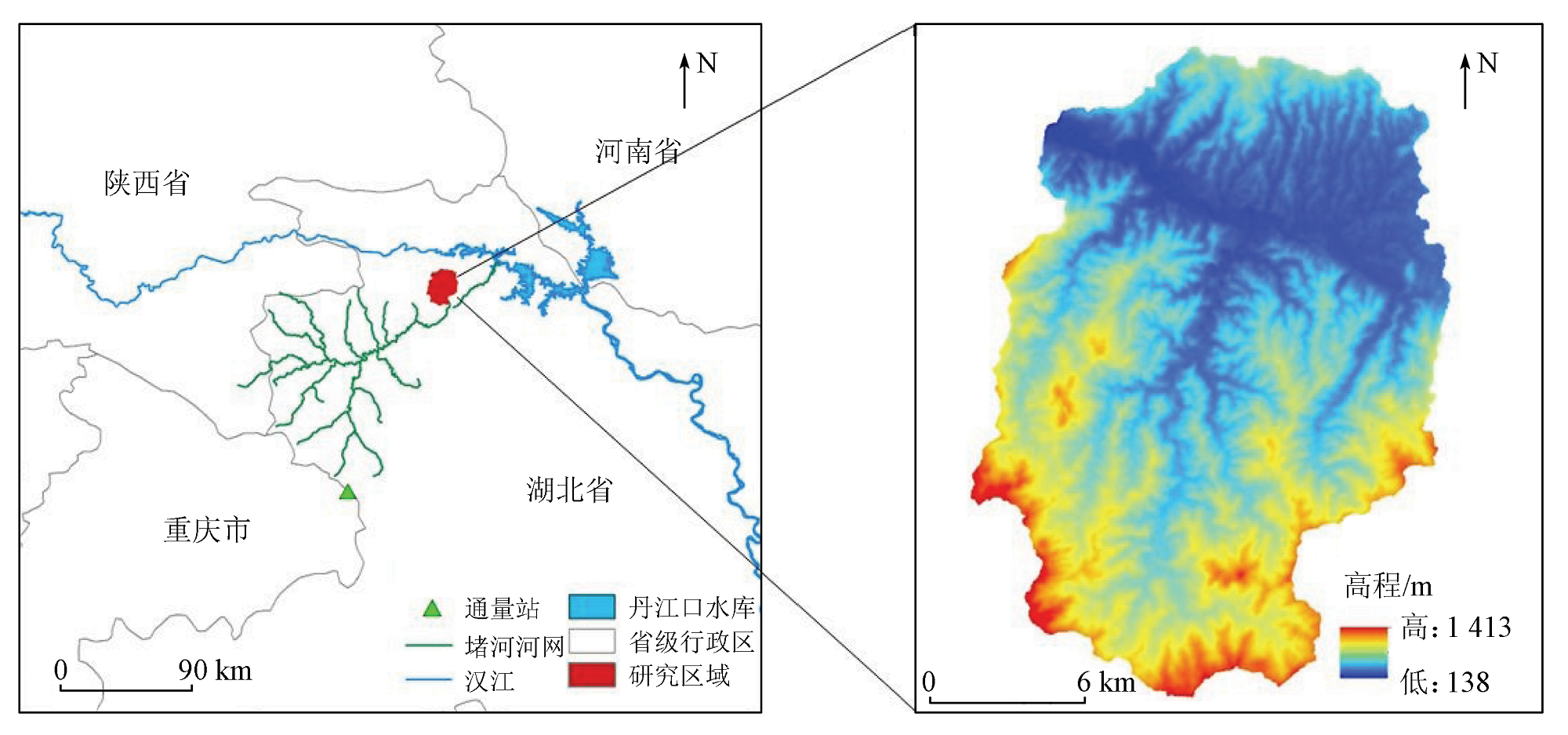
School of Geographic and Information Engineering, China University of Geosciences(Wuhan), Wuhan 430074, China
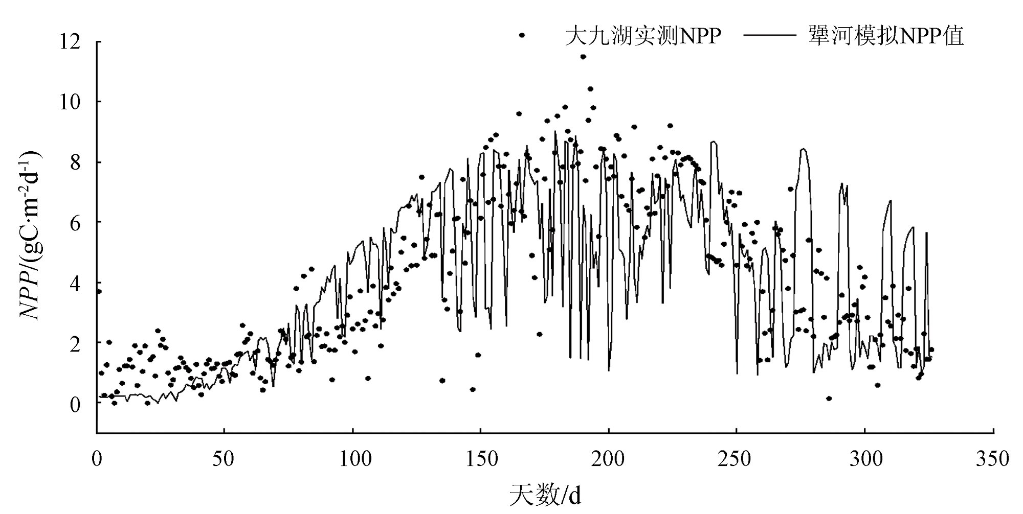
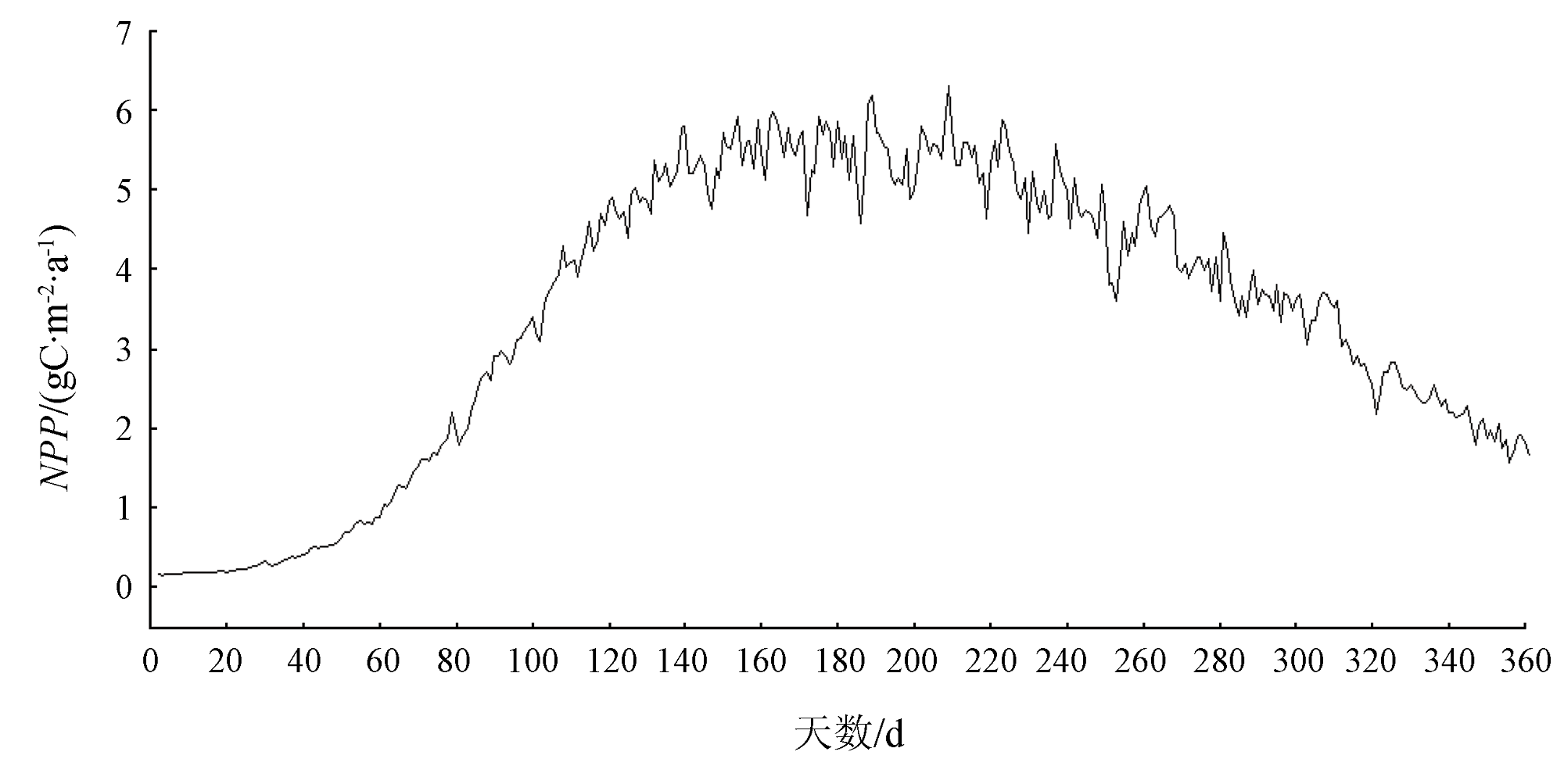
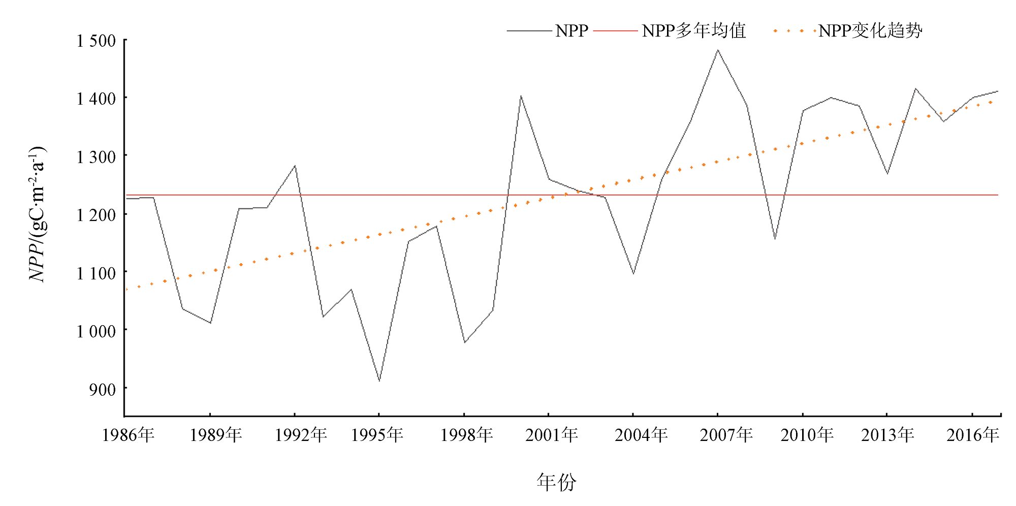
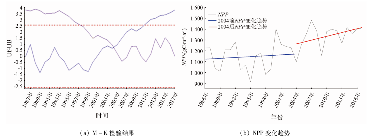
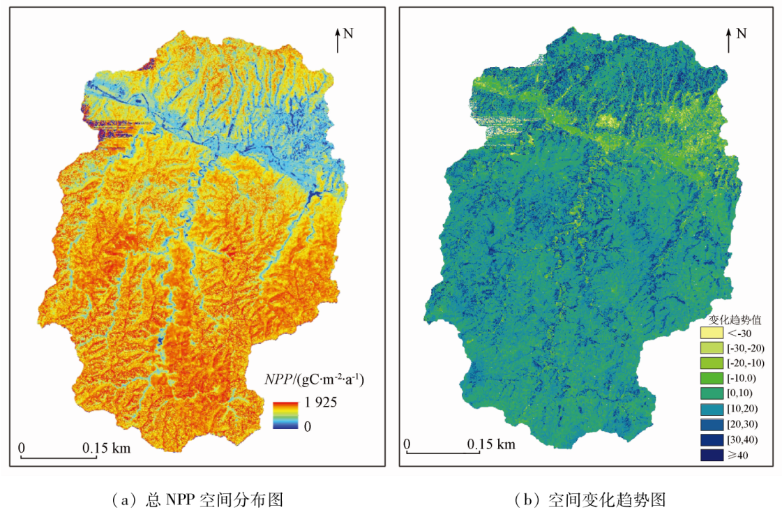
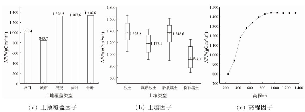
The simulation-based estimation and spatio-temporal variations of the net primary productivity (NPP) of regional vegetation hold critical significance for analyzing regional vegetation quality and carbon balance. This study investigated the Jianghe River basin in western Hubei Province. First, it pre-processed the input data, including land cover, topography, soil, meteorology, and vegetation indices. Based on this, it estimated the NPP of vegetation in the Jianghe River basin from 1986 to 2017 using the BEPS-TerrainlabV2.0 model, with the model's simulation accuracy evaluated. Moreover, this study explored the spatio-temporal variations of the NPP and its response to environmental changes. The results are as follows: ① The NPP of vegetation in the Jianghe River basin exhibited a unimodal distribution, with higher values in summer and lower values in winter, on an intra-annual scale, and a fluctuating rising trend on an inter-annual scale; ② The spatial distribution of the NPP manifested higher values in the north and lower values in the south; ③ The NPP values of different land cover types followed the sequence below: broad-leaved forests > mixed forests > coniferous forests > farmland > urban areas. The NPP rose with an increase in elevation. The NPP values of different soil textures rank below: sandy soil > sandy loam > loamy sand > silty loam; ④ Radiation and temperature manifested the strongest impact on NPP on a daily basis, and the leaf area index (LAI) exhibited the most significant influence on NPP on an annual basis, both passing the 0.01 significance test.
陈佩佩, 张利华, 崔越, 陈俊宏. 基于BEPS-Terrainlab V2.0模型的鄂西犟河流域NPP模拟及环境响应分析[J]. 自然资源遥感, 2023, 35(4): 273-281.
CHEN Peipei, ZHANG Lihua, CUI Yue, CHEN Junhong. Net primary productivity simulation and environmental response analysis of the Jianghe River basin in western Hubei Province based on the BEPS-TerrainLabV2.0 model. Remote Sensing for Natural Resources, 2023, 35(4): 273-281.
Field C B, Behrenfeld M J, Randerson J T, et al. Primary production of the biosphere:Integrating terrestrial and oceanic components[J]. Science, 1998, 281(5374):237-240.
doi: 10.1126/science.281.5374.237
pmid: 9657713
Fang J Y, Ke J H, Tang Z Y, et al. Implications and estimations of four terrestrial productivity parameters[J]. Acta Phytoecologica Sinica, 2001, 25(4):414-419.
[3]
Steffen W, Noble I, M Apps, et al. The terrestrial carbon cycle:Implications for the Kyoto Protocol[J]. Science, 1998, 280(5368):1393-1394.
doi: 10.1126/science.280.5368.1393
[4]
Govind A, Chen J M, Margolis H, et al. A spatially explicit hydro-ecological modeling framework (BEPS-TerrainLab V2.0):Model description and test in a boreal ecosystem in Eastern North America[J]. Journal of Hydrology, 2009, 367(3/4):200-216.
doi: 10.1016/j.jhydrol.2009.01.006
Zhao S H, Qiu G Y, Yang Y H, et al. Advances in the coupled model of remote sensing and hydrology[J]. Ecology and Environment, 2006, 15(6):1391-1396.
[6]
Azhdari Z, Rafeie Sardooi E, Bazrafshan O, et al. Impact of climate change on net primary production (NPP) in south Iran[J]. Environ Monit Assess, 2020, 192(6):409.
doi: 10.1007/s10661-020-08389-w
pmid: 32488356
[7]
Liu J, Chen J M, Cihlar J, et al. Net primary productivity distribution in the BOREAS region from a process model using satellite and surface data[J]. Journal of Geophysical Research:Atmospheres, 1999, 104(D22):27735-27754.
doi: 10.1029/1999JD900768
[8]
Chen J M., Chen X Y, Ju W M, et al. Distributed hydrological model for mapping evapotranspiration using remote sensing inputs[J]. Journal of Hydrology, 2005, 305(1/2/3/4):15-39.
doi: 10.1016/j.jhydrol.2004.08.029
[9]
Sonnentag O, Chen J M, Roulet N T, et al. Spatially explicit simulation of peatland hydrology and carbon dioxide exchange:Influence of mesoscale topography[J]. Journal of Geophysical Research:Biogeosciences, 2008, 113(G2):477-481.
Chen J M, Ju W M, Liu R G, et al. Remote sensing and optimization calculation method of global terrestrial carbon sink[M]. Beijing: Science Press, 2015.
Zhang F M, Ju W M, Chen J M, et al. Studyon evapotranspiration in east Asia using the BEPS ecological model[J]. Journal of Natural Resources, 2010, 25(9):1596-606.
Wang X X, Sun T, Zhu Q J, et al. Spatio-temporal variation of net primary productivity estimated with BEPS model in the urban area[J]. Journal of Arid Land Resources and Environment, 2014, 28(11):1-5.
Tian Y S, Guo Y Y, Zhang P D, et al. Relationship of regional net primary productivity and related meteorological factors[J]. Pratacultural Science, 2010, 27(2):8-17.
Liu Q, Sun B X. Ensure the abrupt runoff change time in Muling river by M-K and sliding T method[J]. Heilongjiang Water Resources, 2015, 1(7):35-37.
[15]
Wu Z F, Zhang L H, Liu D D, et al. Simulation of Evapotranspiration Based on BEPS-TerrainLab V2.0 from 1990 to 2018 in the Dajiuhu Basin[J]. Chinese Geographical Science, 2020, 30(6):1095-1110.
doi: 10.1007/s11769-020-1160-x
Liu S R, Wang B, Guo Q S. Likely Impacts of Rising Atmospheric CO2 Concentration on Plants and Ecosystems Ⅱ.Responses of Plant Population,Community and Forest Ecosystem to Atmospheric CO2 Enrichment[J]. Acta Geographical Sinica, 1996(s1):141-150.
Zhu W Q, Pan Y Z, Zhang J S. Estimation of net primary productivity of Chinese terrestrial vegetation based on remote sensing[J]. Journal of Plant Ecology, 2007, 31(3):413-424.
Liu M L. Landuse/landcover change and terrestrial ecosystem phytomass carbon pool and production in China[D]. Beijing: Institute of Remote Sensing Applications, Chinese Academy of Sciences, 2001.
Xue M, Chen Y Z, Yan M, et al. Simulation and spatio-temporal variation analysis of net primary productivity in Northeast China[J]. Journal of Fuzhou University( Natural Science Edition), 2018, 46(6):821-830.
 2023, Vol. 35
  ), 张利华(