Analysis and summary of land cover classification systems
ZANG Mingrun1,2(), LIAO Yuanhong1, CHEN Zhou1, BAI Yuqi1,3()
1. Department of Earth System Science, Ministry of Education Ecological Field Station for East Asian Migratory Birds and Their Habitatses, Institute for Global Change Studies, Tsinghua University, Beijing 100084, China 2. School of Information Engineering, China University of Geosciences Beijing, Beijing 100083, China 3. Tsinghua Urban Institute, Tsinghua University, Beijing 100084, China
土地覆盖分类体系是土地覆盖研究中的重要内容。该文总结了9种主要土地覆盖分类体系,展示了分类体系和相应数据产品,分析了体系之间的区别和联系,讨论了土地覆盖分类体系精细程度,以及分类体系、空间分辨率、空间覆盖范围的关系,讨论了分类体系之间的语义一致性。论文认为土地覆盖分类体系(land cover classification system,LCCS)和全球土地覆盖精细分辨率观测与监测数据(finer resolution observation and monitoring of global land cover,FROM-GLC)分类体系在精细化分类方面具有优势,高空间分辨率精细分类存在较大技术挑战和实现难度; 目前分类体系之间在逻辑关系、精细分类、名称定义、代码等多方面,存在明显的语义不一致现象; 最后总结指出全球土地覆盖分类研究存在全球化和区域化并存、分类更加精细、产品精度更高、时间间隔和空间分辨率更加细致的发展趋势,数据产品的语义不一致性还需改进,未来需在加强分类体系的兼容性、实现数据产品的共享互操作方面提出解决方案。
Land cover classification systems constitute a significant aspect of land cover research. This study summarized nine major land cover classification systems. It presented these classification systems along with their relevant data products and analyzed the differences and connections between them. Moreover, this study discussed the relationship of their fineness with spatial resolution and coverage, as well as their semantic consistency. The results indicate that LCCS and Finer Resolution Observation and Monitoring of Global Land Cover(FROM-GLC) excel in fine-scale classification but face technical challenges and implementation difficulties in fine-scale classification based on high spatial resolution data. Current classification systems exhibit significant semantic inconsistencies in logical relationships, fine-scale classification, nomenclature, and code. Global land cover classification research shows the following development trends: the coexistence of globalization and regionalization, finer-scale classification, higher product accuracy, and more detailed temporal and spatial resolution. The semantic consistency of data products needs to be enhanced by strengthening the compatibility of classification systems and finding solutions to data product sharing and interoperability.
郁闭至稀疏(> 15%)植被(草原,灌木地,木本植被)的定期泛滥或含水土壤-淡水,半咸水或盐水)(closed to open (>15%) vegetation (grassland, shrubland, woody vegetation) on regularly flooded or waterlogged soil -fresh, brackish or saline water)
190
人造表面和相关区域(城市区域>50%)(artificial surfaces and associated areas (urban areas >50%))
200
裸地(bare areas)
210
水体(water bodies)
220
永久冰雪(permanent snow and ice)
Tab.11 基于LCCS分类体系的GlobCover土地分类体系
编码
类型名
0
没有可用输入数据
111
郁闭的森林,常绿针叶林(closed forest, evergreen needle leaf)
113
郁闭的森林,落叶针叶林(closed forest, deciduous needle leaf)
112
郁闭的森林,常绿阔叶林(closed forest, evergreen, broad leaf)
114
郁闭的森林,落叶阔叶林(closed forest, deciduous broad leaf)
115
郁闭的森林,混交林(closed forest, mixed)
116
郁闭的森林,未知(closed forest, unknown)
121
稀疏的森林,常绿针叶林(open forest, evergreen needle leaf)
123
稀疏的森林,落叶针叶林(open forest, deciduous needle leaf)
122
稀疏的森林,常绿阔叶林(open forest, evergreen broad leaf)
124
稀疏的森林,落叶阔叶林(open forest, deciduous broad leaf)
125
稀疏的森林,混交林(open forest, mixed)
126
稀疏的森林,未知(open forest, unknown)
20
灌木(shrubs)
30
草本植被(herbaceous vegetation)
90
草本湿地(herbaceous wetland)
100
苔藓及地衣植物(moss and lichen)
60
裸地/稀疏植被(bare / sparse vegetation)
40
种植和管护的植被/农业(耕地)(cultivated and managed vegetation/agriculture (cropland))
50
城市/建成区(urban / built up)
70
冰雪(snow & ice)
80
永久性水体(permanent water bodies)
200
开阔海域(open sea)
Tab.12 基于LCCS分类体系的CGLS-LC100土地覆盖分类体系
0级分类体系
LCCS分类体系
精细分类体系
编码
类型名
编码
类型名
农田(cropland)
10
雨养农田
10
雨养农田
11
草本植被
12
树木或灌木覆盖物(果园)
20
灌溉农田
20
灌溉农田
森林(forest)
50
常绿阔叶林
50
常绿阔叶林
60
落叶阔叶林
60
落叶阔叶林
61
郁闭的落叶阔 叶林
62
稀疏的落叶阔 叶林
70
常绿针叶林
70
常绿针叶林
71
郁闭的的常绿针叶林
72
稀疏的常绿针叶林
80
落叶针叶林
80
落叶针叶林
81
郁闭的的落叶针叶林
82
稀疏的落叶针叶林
90
混交林
90
混交林
灌木丛(shrubland)
120
灌木丛
120
灌木丛
121
常绿灌丛
122
落叶灌丛
草原(grassland)
130
草原
130
草原
湿地(wetlands)
180
湿地
180
湿地
不透水面(impervious surfaces)
190
不透水面
190
不透水面
裸露区域(bare areas)
140
地衣和苔藓
140
地衣和苔藓
150
稀疏植被
150
稀疏植被
152
稀疏的灌丛
153
稀疏的草本 覆盖
200
裸露区域
200
裸露区域
201
固结的裸露区域
202
未固结的裸露区域
水体(water body)
210
水体
210
水体
永久冰雪(permanent ice and snow)
220
永久冰雪
220
永久冰雪
Tab.13 基于LCCS分类体系的GLC_FCS30-2015土地覆盖精细分类体系
编码
精细分类体系
10
雨养农田(rainfed cropland)
11
草本植被(herbaceous cover)
12
树木或灌木覆盖物(果园)(tree or shrub cover (orchard))
20
灌溉农田(irrigated cropland)
51
稀疏的常绿阔叶林(open evergreen broadleaved forest)
52
郁闭的常绿阔叶林(closed evergreen broadleaved forest)
61
稀疏的落叶阔叶林(open deciduous broadleaved forest)
62
郁闭的落叶阔叶林(closed deciduous broadleaved forest)
71
稀疏的常绿针叶林(open evergreen needle-leaved forest)
72
郁闭的常绿针叶林(closed evergreen needle-leaved forest)
81
稀疏的落叶针叶林(open deciduous needle-leaved forest)
82
郁闭的落叶针叶林(closed deciduous needle-leaved forest)
91
稀疏的混交林(阔叶和针叶)(open mixed leaf forest (broadleaved and needle-leaved))
92
郁闭的混交林(阔叶和针叶)(closed mixed leaf forest (broadleaved and needle-leaved))
120
灌木丛(shrubland)
121
常绿灌丛(evergreen shrubland)
122
落叶灌丛(deciduous shrubland)
130
草原(grassland)
140
地衣和苔藓(lichens and mosses)
150
稀疏植被(sparse vegetation)
152
稀疏的灌丛(sparse shrubland)
153
稀疏的草本覆盖(sparse herbaceous)
180
湿地(wetlands)
190
不透水面(impervious surfaces)
200
裸露区域(bare areas)
201
固结的裸露区域(consolidated bare areas)
202
未固结的裸露区域(unconsolidated bare areas)
210
水体(water body)
220
永久冰雪(permanent ice and snow)
250
填充值(filled value)
Tab.14 基于LCCS分类体系的GLC_FCS30-2020土地覆盖精细分类体系
一级类(编码+地类)
二级类(编码+地类)
10耕地和管理地(cultivated and managed areas)
10耕地和管理地
20树(tree)
21常绿阔叶
22落叶阔叶,郁闭,有叶
23落叶阔叶,郁闭,落叶
24落叶阔叶,稀疏,有叶
25落叶阔叶,稀疏,落叶
26常绿针叶
27落叶针叶,有叶
28落叶针叶,落叶
29混合叶型,有叶
30混叶型,落叶
31树木覆盖,烧毁(tree cover, burnt)
31树木覆盖,烧毁
40灌木或草本覆盖(shrub cover or herbaceous)
41常绿灌木
42落叶灌木
43落叶灌木
44草本,有叶
45草本,落叶
50湿地(wetland)
51树木覆盖,定期淹没,淡水和半咸水
52树木覆盖,定期淹没,咸水
53经常被淹的灌木和/或草本覆盖,有叶
54经常被淹的灌木和/或草本覆盖,落叶
60混合的植被(mosaic-vegetation)
61树木/其他自然植被
62作物/树木/其他自然植被
63作物/灌木或草本
64落叶植被
65作物/树木/其他自然植被,落叶
66作物/灌木或草本,落叶
70非植被(non-vegetation)
71裸露区域
72水体
73人造表面和相关区域
74冰雪
80稀疏草本或稀疏灌木覆盖(sparse herbaceous or sparse shrub cover)
80稀疏草本或稀疏灌木覆盖
Tab.15 基于LCCS分类体系的iMap World 1.0土地覆盖制图分类体系
编码
土地覆盖类型
10
树木覆盖(tree cover)
20
灌木(shrubland)
30
草地(grassland)
40
农田(cropland)
50
建成区(built-up)
60
裸地/稀疏植被(bare / sparse vegetation)
70
冰雪(snow and ice)
80
永久性水体(permanent water bodies)
90
草本湿地(herbaceous wetland)
95
红树林(mangroves)
100
苔藓及地衣植物(moss and lichen)
Tab.16 基于LCCS分类体系的WorldCover 10 m土地覆盖分类体系
编码
类型
01
人工地表(artificial surfaces)
02
耕地(cropland)
03
草地(grassland)
04
树木覆盖区(tree covered areas)
05
灌木覆盖区(shrubs covered areas)
06
草木植被、水生或定期淹没(herbaceous vegetation, aquatic or regularly flooded)
07
红树林(mangroves)
08
稀疏植被(sparse vegetation)
09
裸土(baresoil)
10
雪和冰川(snow and glaciers)
11
水体(water bodies)
Tab.17 基于LCCS分类体系的GLC-SHARE全球土地覆盖汇总类别
编码
类别
1
树木覆盖(tree cover)
2
灌木覆盖(shrub cover)
3
草本植被/草地(herbaceous vegetation/grassland)
4
栽培和管理的植被(cultivated and managed)
5
栽培和管理/自然植被的镶嵌(mosaic of cultivated and managed/natural vegetation)
Chen J, Chen J. GlobeLand30:Operational global land cover mapping and big-data analysis[J]. Scientia Sinica(Terrae), 2018, 48(10):1391-1392.
[4]
Bounoua L, DeFries R, Collatz G J, et al. Effects of land cover conversion on surface climate[J]. Climatic Change, 2002, 52(1):29-64.
doi: 10.1023/A:1013051420309
Chen J, Liao A P, Chen J, et al. 30-meter global land cover data product-Globe Land30[J]. Geomatics World, 2017(1):1-8.
[6]
Yang H, Li S N, Chen J, et al. The standardization and harmonization of land cover classification systems towards harmonized datasets:A review[J]. ISPRS International Journal of Geo-Information, 2017, 6(5):154.
doi: 10.3390/ijgi6050154
Zhang J, Feng Z M, Jiang L G. Progress on studies of land use/land cover classification systems[J]. Resources Science, 2011, 33(6):1195-1203.
[8]
He C Y, Zhang J X, Liu Z F, et al. Characteristics and progress of land use/cover change research during 1990—2018[J]. Journal of Geographical Sciences, 2022, 32(3):537-559.
doi: 10.1007/s11442-022-1960-2
[9]
Pérez-Hoyos A, Rembold F, Kerdiles H, et al. Comparison of glo-bal land cover datasets for cropland monitoring[J]. Remote Sensing, 2017, 9(11):1118.
doi: 10.3390/rs9111118
Wang R C. Discussion on the land classification[J]. Journal of Zhejiang University (Agric.& Life Sci.), 2002, 28(4):355-361.
[12]
Deb S, Nathr R. Land use/cover classification:An introduction review and comparison[J]. Global Journals of Research in Engineering, 2012, 12(E1):5-16.
[13]
Wang J, He T, Zhou Q, et al. Developing land use/cover classification system based on remote sensing data in China[C]// Remote Sensing for Environmental Monitoring,GIS Applications,and Geology IV.SPIE, 2004,5574:52-60.
Lyu Y X, Zhang Y X, Ma C L, et al. Land use classification comparative analysis between IPCC and China[J]. Geospatial Information, 2022, 20(7):22-25.
[15]
Anderson J R, Hardy E E, Roach J T, et al. A land use and land cover classification system for use with remote sensor data[M]. Washington:U.S.Government Printing Office,1976.
[16]
Yang L M, Jin S M, Danielson P, et al. A new generation of the United States National Land Cover Database:Requirements,research priorities,design,and implementation strategies[J]. ISPRS Journal of Photogrammetry and Remote Sensing, 2018,146:108-123.
[17]
Wickham J, Stehman S V, Sorenson D G, et al. Thematic accuracy assessment of the NLCD 2016 land cover for the conterminous United States[J]. Remote Sensing of Environment, 2021,257:112357.
[18]
Vogelmann J E, Howard S M, Yang L, et al. Completion of the 1990s national land cover data set for the conterminous United States from Landsat thematic mapper data and ancillary data sources[J]. Photogrammetric Engineering and Remote Sensing, 2001,67:650-655,657-659,661-662.
[19]
Cunningham D J, Melican J E, Wemmelmann E, et al. GeoCover LC:A moderate resolution global land cover database[C/OL]//Proceedings of the 22nd Annual Esri International User Conference (Esri UC 2002).San Diego,USA, 2002.https://proceedings.esri.com/library/userconf/proc02/pap0811/p0811.htm.
[20]
Bossard M, Feranec J, Otahel J. CORINE land cover technical guide:Addendum 2000[R/OL]. Copenhagen: European Environment Agency.(2000-05-29)[2025-11-03].https://www.eea.europa.eu/publications/tech40add.
[21]
Büttner G. CORINE land cover and land cover change products[M]//Land Use and Land Cover Mapping in Europe.Dordrecht:Springer Netherlands,2014:55-74.
[22]
Loveland T R, Reed B C, Brown J F, et al. Development of a global land cover characteristics database and IGBP DISCover from 1 km AVHRR data[J]. International Journal of Remote Sensing, 2000, 21(6-7):1303-1330.
doi: 10.1080/014311600210191
[23]
Friedl M A, Strahler A H, Hodges J C F, et al. ISLSCP II MODIS(Collection 4) IGBP Land Cover,2000—2001[DB/OL].Oak Ridge, TN: ORNL Distributed Active Archive Center, 2010[2025-11-03].https://www.earthdata.nasa.gov/data/catalog/ornl-cloud-modis-landcover-xdeg-968-1.
[24]
Hansen M C, Reed B. A comparison of the IGBP DISCover and University of Maryland 1 km global land cover products[J]. International Journal of Remote Sensing, 2000, 21(6-7):1365-1373.
doi: 10.1080/014311600210218
[25]
Hansen M C, Defries R S, Townshend J R G, et al. Global land cover classification at 1 km spatial resolution using a classification tree approach[J]. International Journal of Remote Sensing, 2000, 21(6-7):1331-1364.
doi: 10.1080/014311600210209
[26]
Townshend J, Zhan X, DeFries R. MODIS enhanced land cover and land cover change product algorithm theoretical basis documents (ATBD) version 2.0[R/OL]. Greenbelt, MD: NASA Goddard Space Flight Center / University of Maryland, 1999(1999-05-01)[2025-11-03].https://modis.gsfc.nasa.gov/data/atbd/atbd_mod29.pdf.
[27]
Sulla-Menashe D, Friedl M A. User guide to collection 6 MODIS land cover(MCD12Q1 & MCD12C1) product[EB/OL]. 2018(2018-05-14)[2025-11-03].https://lpdaac.usgs.gov/documents/101/MCD12_User_Guide_V6.pdf.
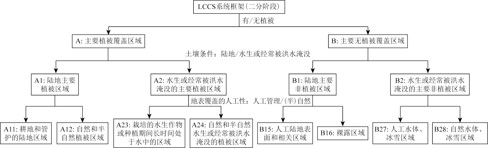
He Y H, Xie J Q, Sun Y. FAO/UNEP-land cover classification system (LCCS) and use for reference[J]. China Land Science, 2005, 19(6):45-49.
[29]
Di Gregorio A, Jansen L J M. Land cover classification system:Classification concepts and user manual(software version 2)[M/OL]. Rome: Food and Agriculture Organization of the United Nations, 2005[2025-11-03].https://www.fao.org/4/y7220e/y7220e00.htm.
[30]
Herold M, Schmullius C. Report on the harmonization of global and regional land cover products[R/OL].(2004-07-16)[2025-11-03].https://gofcgold.org/sites/default/files/docs/GOLD_20.pdf.
[31]
Bartholome E, Belward A S. GLC2000:A new approach to global land cover mapping from Earth observation data[J]. International Journal of Remote Sensing, 2005, 26(9):1959-1977.
doi: 10.1080/01431160412331291297
[32]
Tateishi R, Uriyangqai B, Al-Bilbisi H, et al. Production of global land cover data-GLCNMO[J]. International Journal of Digital Earth, 2011, 4(1):22-49.
doi: 10.1080/17538941003777521
[33]
Tateishi R, Hoan N T, Kobayashi T, et al. Production of global land cover Data-GLCNMO2008[J]. Journal of Geography and Geology, 2014, 6(3):p99.
[34]
Kobayashi T, Tateishi R, Alsaaideh B, et al. Production of global land cover data-GLCNMO2013[J]. Journal of Geography and Geology, 2017, 9(3):1.
[35]
Defourny P, Lamarche C, Bontemps S, et al. Land Cover CCI:Product user guide,version 2.0[R/OL].(2017-04-10)[2025-11-03].https://maps.elie.ucl.ac.be/CCI/viewer/download/ESACCI-LC-Ph2-PUGv2_2.0.pdf.
[36]
Bontemps S, Herold M, Kooistra L, et al. Revisiting land cover observation to address the needs of the climate modeling community[J]. Biogeosciences, 2012, 9(6):2145-2157.
doi: 10.5194/bg-9-2145-2012
[37]
Defourny P, Schouten L, Bartalev S, et al. Accuracy assessment of a 300 m global land cover map:The GlobCover experience[C]//33rd International Symposium on Remote Sensing of Environment (ISRSE):Sustaining the Millennium Development Goals.Tucson, AZ (United States of America): International Center for Remote Sensing of Environment (ICRSE),2009:JRC54524.
[38]
Buchhorn M, Smets B, Bertels L, et al. Copernicus global land ser-vice:Land cover 100 m:Version 3 Globe 2015—2019:Product user manual[R/OL].(2020-09-08)[2025-11-03].https://zenodo.org/records/3938963.
[39]
Zhang X, Liu L Y, Chen X D, et al. GLC_FCS30:Global land-cover product with fine classification system at 30 m using time-series Landsat imagery[J]. Earth System Science Data, 2021, 13(6):2753-2776.
doi: 10.5194/essd-13-2753-2021
[40]
Liu L Y, Zhang X, Chen X D, et al. GLC_FCS30-2020:Global land cover with fine classification system at 30 m in 2020(v1.2)[DB/OL].(2020-11-18)[2025-11-03].https://zenodo.org/records/4280923.
[41]
Liu H, Gong P, Wang J, et al. Production of global daily seamless data cubes and quantification of global land cover change from 1985 to 2020 - iMap World 1.0[J]. Remote Sensing of Environment, 2021,258:112364.
[42]
Zanaga D, Van De Kerchove R, De Keersmaecker W, et al. ESA WorldCover 10 m 2020 v100[DB/OL].(2021-10-20)[2025-11-03].https://zenodo.org/records/5571936.
[43]
Latham J, Cumani R, Rosati I, et al. Global Land Cover SHARE (GLC-SHARE) database:Beta-Release version 1.0-2014[EB/OL].[2025-11-03].https://www.fao.org/uploads/media/glc-share-doc.pdf.
[44]
See L, Schepaschenko D, Lesiv M, et al. Building a hybrid land cover map with crowdsourcing and geographically weighted regression[J]. ISPRS Journal of Photogrammetry and Remote Sensing, 2015,103:48-56.
[45]
Fritz S, McCallum I, Schill C, et al. Geo-Wiki.Org:The use of crowdsourcing to improve global land cover[J]. Remote Sensing, 2009, 1(3):345-354.
doi: 10.3390/rs1030345
[46]
Fritz S, McCallum I, Schill C, et al. Geo-Wiki:An online platform for improving global land cover[J]. Environmental Modelling & Software, 2012,31:110-123.
[47]
Jun C, Ban Y F, Li S N. Open access to earth land-cover map[J]. Nature, 2014, 514(7523):434.
Xu X C, Li B J, Liu X P, et al. Mapping annual global land cover changes at a 30 m resolution from 2000 to 2015[J]. National Remote Sensing Bulletin, 2021, 25(9):1896-1916.
[49]
Gong P, Wang J, Yu L, et al. Finer resolution observation and monitoring of global land cover:First mapping results with Landsat TM and ETM+ data[J]. International Journal of Remote Sensing, 2013, 34(7):2607-2654.
doi: 10.1080/01431161.2012.748992
[50]
Gong P, Liu H, Zhang M N, et al. Stable classification with limited sample:Transferring a 30-m resolution sample set collected in 2015 to mapping 10-m resolution global land cover in 2017[J]. Science Bulletin, 2019, 64(6):370-373.
doi: 10.1016/j.scib.2019.03.002
[51]
Yu L, Wang J, Gong P. Improving 30 m global land-cover map FROM-GLC with time series MODIS and auxiliary data sets:A segmentation-based approach[J]. International Journal of Remote Sensing, 2013, 34(16):5851-5867.
doi: 10.1080/01431161.2013.798055
[52]
Yu L, Wang J, Li X C, et al. A multi-resolution global land cover dataset through multisource data aggregation[J]. Science China Earth Sciences, 2014, 57(10):2317-2329.
doi: 10.1007/s11430-014-4919-z
[53]
Liu H, Gong P, Wang J, et al. Annual dynamics of global land cover and its long-term changes from 1982 to 2015[J]. Earth System Science Data, 2020, 12(2):1217-1243.
doi: 10.5194/essd-12-1217-2020
[54]
Karra K, Kontgis C, Statman-Weil Z, et al. Global land use/land cover with Sentinel 2 and deep learning[C]// 2021 IEEE International Geoscience and Remote Sensing Symposium IGARSS. IEEE, 2021:4704-4707.
[55]
Brown C F, Brumby S P, Guzder-Williams B, et al. Dynamic World,Near real-time global 10 m land use land cover mapping[J]. Scientific Data, 2022,9:251.
[56]
Dong R M, Li C, Fu H H, et al. Improving 3-m resolution land cover mapping through efficient learning from an imperfect 10-m resolution map[J]. Remote Sensing, 2020, 12(9):1418.
doi: 10.3390/rs12091418
[57]
Li Z H, He W, Cheng M F, et al. SinoLC-1:The first 1-meter resolution national-scale land-cover map of China created with a deep learning framework and open-access data[J]. Earth System Science Data, 2023, 15(11):4749-4780.
doi: 10.5194/essd-15-4749-2023
[58]
Zhang Y D, Chen G, Myint S W, et al. UrbanWatch:A 1-meter resolution land cover and land use database for 22 major cities in the United States[J]. Remote Sensing of Environment, 2022,278:113106.
[59]
Shi Q, Liu M X, Marinoni A, et al. UGS-1m:Fine-grained urban green space mapping of 31 major cities in China based on the deep learning framework[J]. Earth System Science Data, 2023, 15(2):555-577.
doi: 10.5194/essd-15-555-2023
[60]
Brandt M, Tucker C J, Kariryaa A, et al. An unexpectedly large count of trees in the West African Sahara and Sahel[J]. Nature, 2020, 587(7832):78-82.
doi: 10.1038/s41586-020-2824-5
 2025, Vol. 37
  ), 廖远鸿1, 陈舟1, 白玉琪1,3(