Monitoring and analyzing land subsidence in Qinfang, Guangxi based on Sentinel-1A data
MING Xiaoyong1,2(), TIAN Yichao1,2(), ZHANG Qiang1, TAO Jin1, ZHANG Yali1, LIN Junliang1
1. Key Laboratory of Marine Geographic Information Resources Development and Utilization, College of Resources and Environment, Beibu Gulf University, Qinzhou 535000, China 2. Guangxi Key Laboratory of Marine Disaster in the Beibu Gulf, Beibu Gulf Ocean Development Research Center, Beibu Gulf University, Qinzhou 535000, China
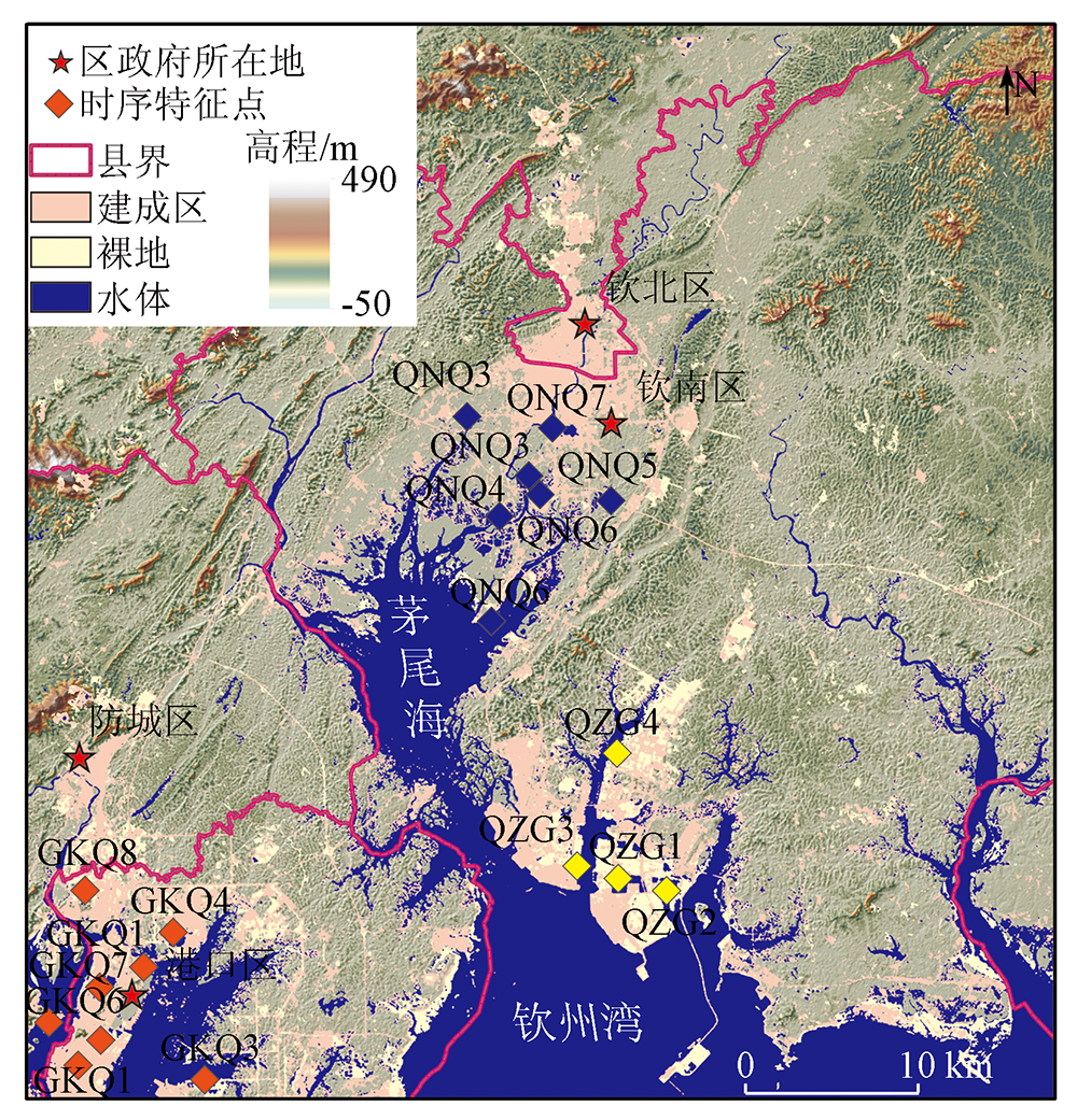
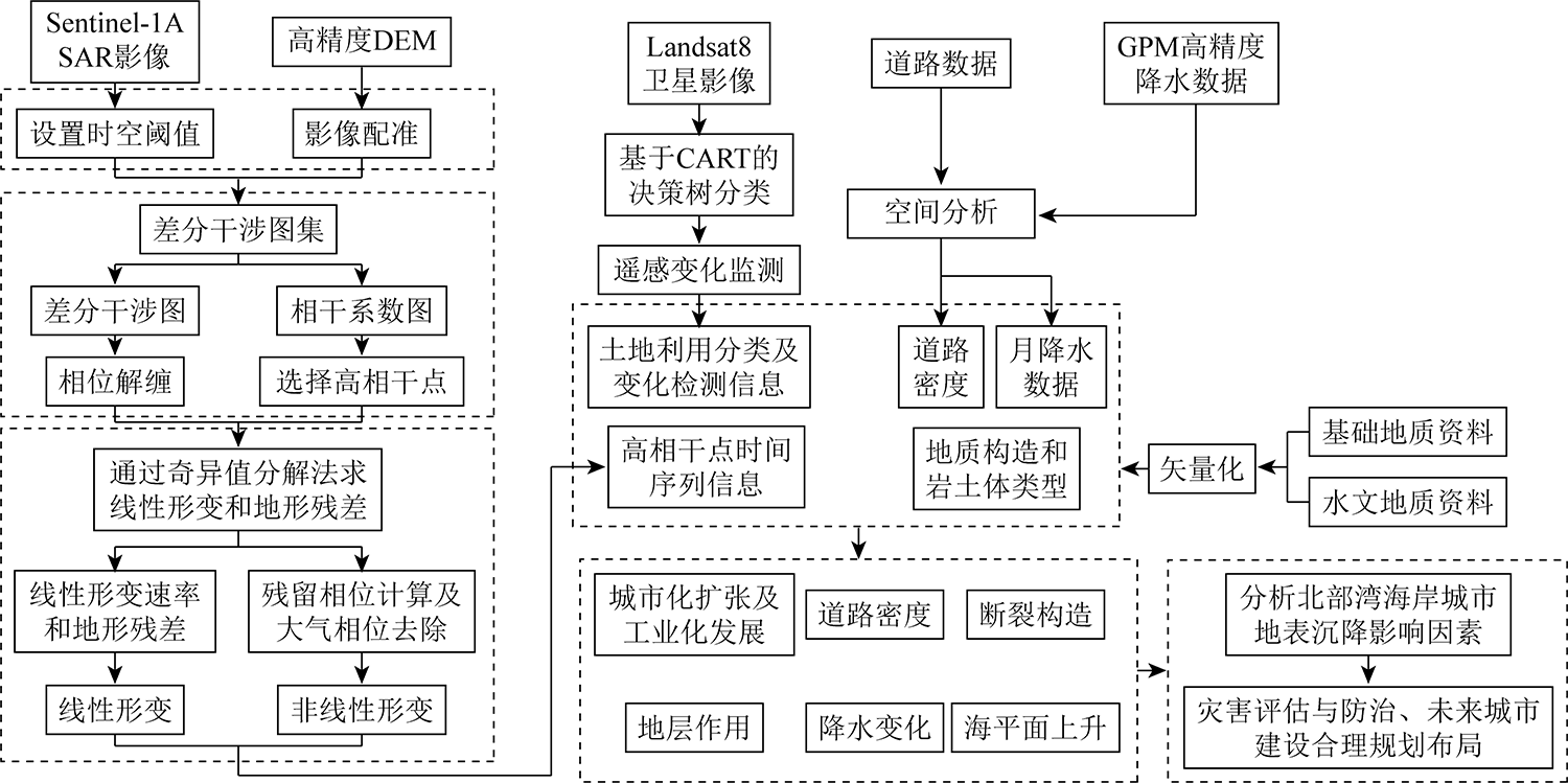
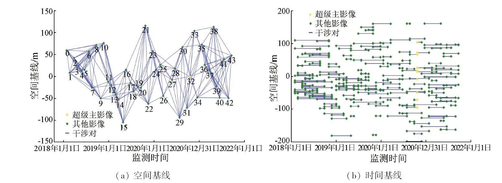
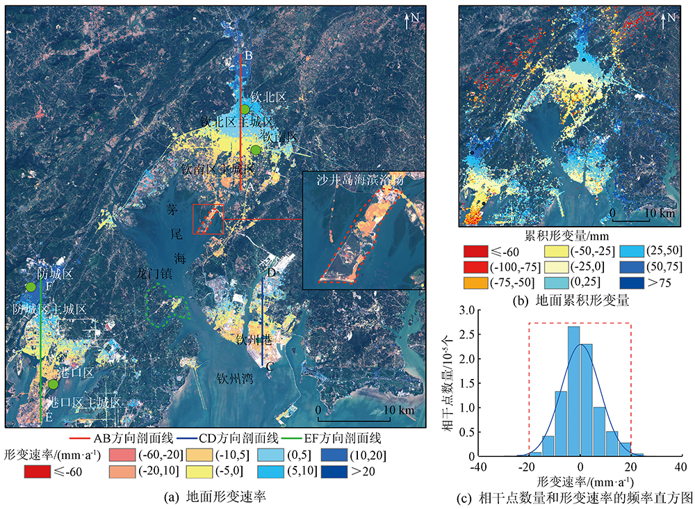
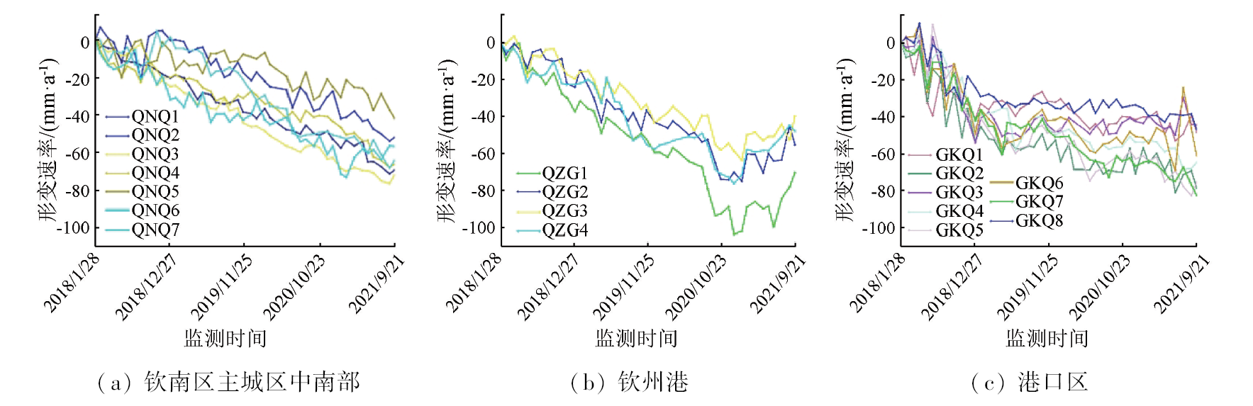
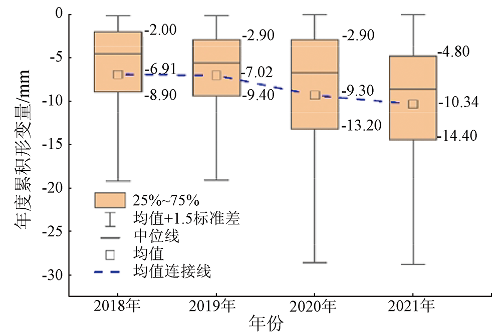
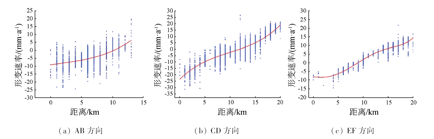
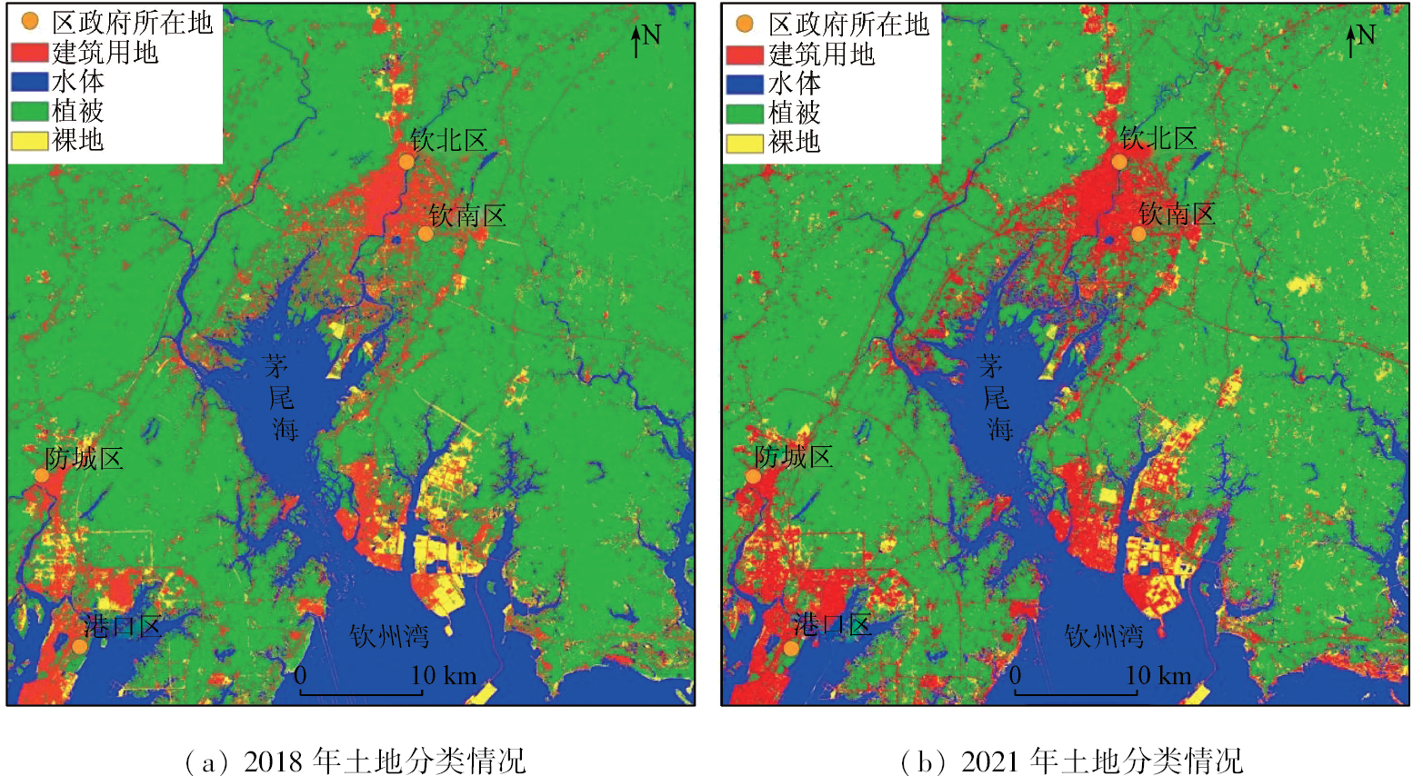
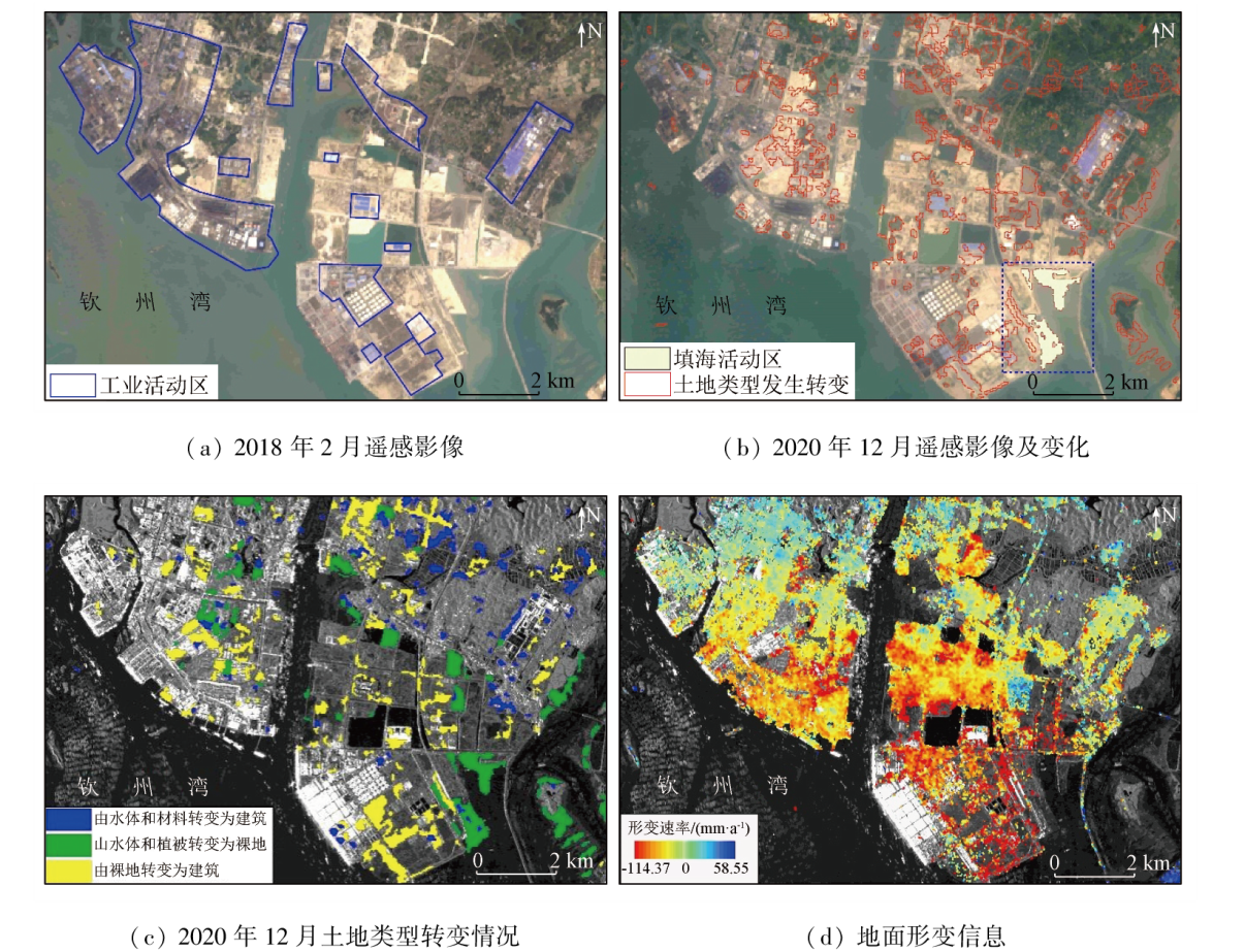
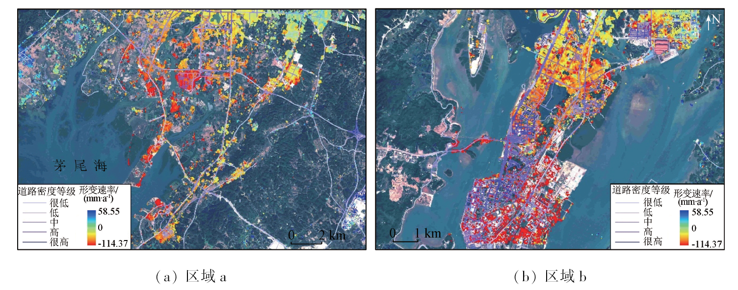
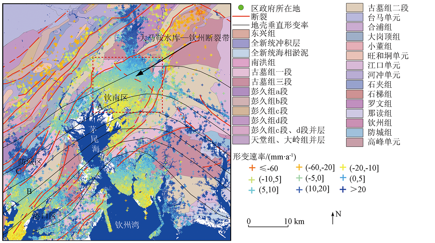
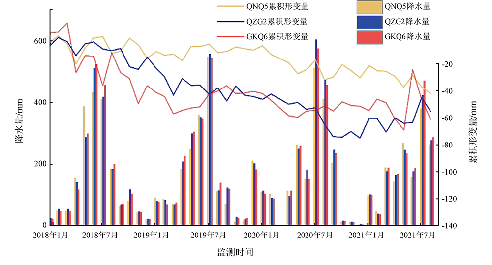
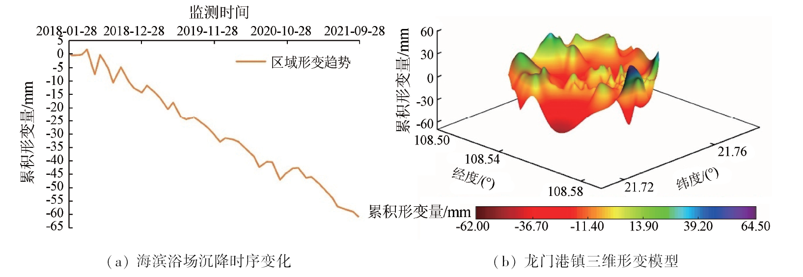
This study aims to lay the scientific foundation for regional disaster prediction, prevention, and control, as well as urban planning, by analyzing the spatio-temporal distribution, evolutionary patterns, and driving factors of land subsidence in the Qinfang area, Guangxi Province, China. Using the small baseline subset interferometric synthetic aperture radar (SBAS-InSAR) technique, this study extracted information on land subsidence in the study area during 2018—2021 from 45 scenes of Sentinel-1A SAR images. By combining the geological setting, precipitation, land use, and road data and using methods such as GIS spatial analysis, mathematical statistics, remote sensing image classification, and change detection, this study conducted visual and quantitative analyses of the overall characteristics, spatio-temporal evolutionary trends, and influencing factors of land subsidence in the study area. The results show that: ① In the spatial dimension, the ground deformations, at rates ranging from -114.37 to 58.55 mm/a within the study area, exhibited extensive but significantly nonuniform distributions during 2018—2021. Consequently, three primary subsidence centers emerged in the central and southern urban areas of Qinnan District, Qinzhou Port, and the port area, with subsidence areas expanding southward annually; ② In the temporal dimension, the subsidence centers displayed an overall uneven subsidence trend over time. Besides, they exhibited periodic rebounds, with a maximum rebound amplitude of 18.4 mm; ③ In terms of influencing factors, primary factors causing land subsidence in the study area included urbanization, road density, tectonic movement, stratigraphy, precipitation, and sea level rise, which play a predominant role in the expansion and intensification of land subsidence.
明小勇, 田义超, 张强, 陶进, 张亚丽, 林俊良. 基于Sentinel-1A钦防地区地面沉降监测与分析[J]. 自然资源遥感, 2024, 36(1): 35-48.
MING Xiaoyong, TIAN Yichao, ZHANG Qiang, TAO Jin, ZHANG Yali, LIN Junliang. Monitoring and analyzing land subsidence in Qinfang, Guangxi based on Sentinel-1A data. Remote Sensing for Natural Resources, 2024, 36(1): 35-48.
Dong K G, Zhou J, Yu Q, et al. Feature of the land subsidence and its damage in Tianjin City[J]. Journal of Geological Hazards and Environment Preservation, 2007, 18(1):67-70.
Ministry of Land and Resources of the People’s Republic of China. DZ/T 0283—2015 Specification for survey and monitoring of land subsidence[S]. Beijing: Standards Press of China, 2015.
Li G Y, Zhang R, Liu G X, et al. Land subsidence detection and analysis over Beijing-Tianjin-Hebei area based on Sentinel-1A TS-DInSAR[J]. Journal of Remote Sensing, 2018, 22(4):633-646.
Du D, Liu H W, Zhou J H, et al. Study of the characteristics and influencing factors of land subsidence in the Tongzhou district of Beijing[J]. Acta Geologica Sinica, 2022, 96(2):712-725.
Zhou L, Lu J J, Wen X L, et al. Spatial-temporal characteristics analysis of ground subsidence in central urban areas of Wuhan based on small baseline subset interferometric synthetic aperture Radar[J]. Science Technology and Engineering, 2021, 21(1): 40-46.
Shi M, Gong H L, Chen B B, et al. Monitoring of land subsidence in Beijing-Tianjin-Hebei plain during 2016—2018 based on InSAR and Sentinel-1A data[J]. Remote Sensing for Natural Resources, 2021, 33(4):55-63.doi:10.6046/zrzyyg.2020341.
Li W P, Wang L F, Guo H P, et al. Effectiveness and countermeasures of land subsidence control in China[J]. China Water Resources, 2021(7):32-35.
[7]
Loesch E, Sagan V. SBAS analysis of induced ground surface deformation from wastewater injection in east central Oklahoma,USA[J]. Remote Sensing, 2018, 10(2): 283.
doi: 10.3390/rs10020283
[8]
Doke R, Kikugawa G, Itadera K. Very local subsidence near the hot spring region in Hakone Volcano,Japan,inferred from InSAR time series analysis of ALOS/PALSAR data[J]. Remote Sensing, 2020, 12(17):2842.
doi: 10.3390/rs12172842
[9]
Lubitz C, Motagh M, Wetzel H U, et al. Remarkable urban uplift in Staufen im Breisgau,Germany:Observations from TerraSAR-X InSAR and leveling from 2008 to 2011[J]. Remote Sensing, 2013, 5(6):3082-3100.
doi: 10.3390/rs5063082
Dong S, Zhang Y H, Li M J, et al. Surface subsidence research of Lianyungang and northern Yancheng based on time series InSAR technology[J]. Science of Surveying and Mapping, 2019, 44(3):57-62.
Li M M, Fan X T, Chen C, et al. Monitoring and interpretation of land subsidence in mining areas in Xuzhou City during 2016—2018[J]. Remote Sensing for Natural Resources, 2021, 33(4):43-54.doi:10.6046/zrzyyg.2020137.
Ren C, Shi X J, Zhou L, et al. Land subsidence detection and analysis along subway based on Sentinel-1A time series interferometry synthetic aperture Radar[J]. Science Technology and Engineering, 2020, 20(2):803-808.
Shi X G, Zhang L, Xu Q, et al. Monitoring slope displacements of loess terrace using time series InSAR analysis technique[J]. Geomatics and Information Science of Wuhan University, 2019, 44(7):1027-1034.
Xu Q, Pu C H, Zhao K Y, et al. Time series InSAR monitoring and analysis of spatiotemporal evolution characteristics of land subsidence in Yan’an new district[J]. Geomatics and Information Science of Wuhan University, 2021, 46(7):957-969.
[15]
Dai K R, Shi X L, Gou J S, et al. Diagnosing subsidence geohazard at Beijing Capital International Airport,from high-resolution SAR interferometry[J]. Sustainability, 2020, 12(6): 2269.
doi: 10.3390/su12062269
[16]
Zhang Z J, Wang C, Wang M M, et al. Surface deformation monitoring in Zhengzhou City from 2014 to 2016 using time-series InSAR[J]. Remote Sensing, 2018, 10(11): 1731.
doi: 10.3390/rs10111731
Lin H, Ma P F, Wang W X. Urban infrastructure health monitoring with spaceborne multi-temporal synthetic aperture Radar interfero-metry[J]. Acta Geodaetica et Cartographica Sinica, 2017, 46(10):1421-1433.
Zhu J J, Li Z W, Hu J. Research progress and methods of InSAR for deformation monitoring[J]. Acta Geodaetica et Cartographica Sinica, 2017, 46(10):1717-1733.
doi: 10.11947/j.AGCS.2017.20170350
He P, Xu C J, Wen Y M, et al. Analysis and simulation for time series InSAR error model[J]. Geomatics and Information Science of Wuhan University, 2016, 41(6):752-758.
Pan C, Jiang L M, Sun Q S, et al. Monitoring and analyzing Chengdu ground subsidence based on InSAR technology by using Sentinel-1 Radar image[J]. Journal of Geodesy and Geodynamics, 2020, 40(2):198-203.
Yang W, He Y, Zhang L F, et al. InSAR monitoring of 3D surface deformation in Jinchuan mining area,Gansu Province[J]. Remote Sensing for Natural Resources, 2022, 34(1):177-188.doi:10.6046/zrzyyg.2021107.
[22]
Lanari R, Mora O, Manunta M, et al. A small-baseline approach for investigating deformations on full-resolution differential SAR interferograms[J]. IEEE Transactions on Geoscience and Remote Sensing, 2004, 42(7):1377-1386.
doi: 10.1109/TGRS.2004.828196
[23]
Ferretti A, Prati C, Rocca F. Permanent scatterers in SAR interferometry[C]// IEEE International Geoscience and Remote Sensing Symposium.IEEE, 1999:1528-1530.
[24]
Berardino P, Fornaro G, Lanari R, et al. A new algorithm for surface deformation monitoring based on small baseline differential SAR interferograms[J]. IEEE Transactions on Geoscience and Remote Sensing, 2002, 40(11): 2375-2383.
doi: 10.1109/TGRS.2002.803792
Liu Q, Yue G S, Ding X B, et al. Temporal and spatial characteristics analysis of deformation along Foshan subway using time series InSAR[J]. Geomatics and Information Science of Wuhan University, 2019, 44(7):1099-1106.
Zhou L, Guo J M, Li X, et al. Monitoring and analyzing on ground settlement in Beijing area based on SBAS-InSAR[J]. Journal of Geodesy and Geodynamics, 2016, 36(9):793-797.
Zhang Z W, Yang F, Wu W H, et al. Study of land subsidence and groundwater based on SBAS time-series analysis[J]. Science of Surveying and Mapping, 2016, 41(6):64-69,134.
Cao Q, Chen B B, Gong H L, et al. Monitoring of land subsidence in Beijing-Tianjin-Hebei urban by combination of SBAS and IPTA[J]. Journal of Nanjing University(Natural Science), 2019, 55(3):381-391.
Mo Y, Jiang L M, Sun Q S, et al. Monitoring and analysis of land subsidence in Shangyu area of Hangzhou Bay by SBAS-InSAR[J]. Science of Surveying and Mapping, 2020, 45(10):77-84.
Guo L P, Yue J P, Yue S. Application of SBAS technique in surface subsidence monitoring of Nanjing Hexi area[J]. Bulletin of Surveying and Mapping, 2017(3):26-28,41.
doi: 10.13474/j.cnki.11-2246.2017.0077
Xiong J C, Nie Y J, Luo Y, et al. Monitoring urban land subsidence by dual-polarization Sentinel-1 data:A case study of Shanghai[J]. Bulletin of Surveying and Mapping, 2019(11):98-102,129.
Dong S C, Chong Y H, Hu H, et al. Ground subsidence monitoring during 2015—2018 in Changzhou based on time series InSAR method[J]. Journal of Nanjing University(Natural Science), 2019, 55(3):370-380.
Zhao C Y, Zhang Q, Zhu W. Monitoring on Xi’an ground fissures deformation with TerraSAR-X data[J]. Geomatics and Information Science of Wuhan University, 2012, 37(1):81-85.
Zhang Y M, Wang P, Luo X, et al. Monitoring Xi’an land subsidence using Sentinel-1 images and SBAS-InSAR technology[J]. Bulletin of Surveying and Mapping, 2017(4):93-97.
Li D, Deng K Z, Gao X X, et al. Monitoring and analysis of surface subsidence in mining area based on SBAS-InSAR[J]. Geomatics and Information Science of Wuhan University, 2018, 43(10):1531-1537.
Jiang D C, Zhang J X, Zhang Y H, et al. Ground deformation over century-long coal mining city monitored through incorporating both PS and SBAS InSAR:A case study of Xuzhou[J]. Bulletin of Surveying and Mapping, 2017(1):58-64.
[37]
Henry E R, Hofrichter J. Singular value decomposition:Application to analysis of experimental data[J]. Methods in Enzymology, 1992, 210: 129-192.
Qin W, Huang Q Y, Yu L, et al. Surface subsidence monitoring during the construction of Nanning subways[J]. Journal of Geo-Information Science, 2019, 21(9):1467-1478.
Chen H M, Wu X H, Zhang Y, et al. Carboniferous lithofacies paleogeography and mineralization in south China[M]: Geological Publishing House, 1994:34-35.
He J, Li Q H, Liu H Q, et al. Review on the main geological environmental problems in Beibu Gulf Economic Zone[J]. Geology and Mineral Resources of South China, 2015, 31(1):96-103.
Wei Y D. Elementary discussion on the main engineering geologic problems of Guangxi coastal region sea embankment project[J]. Guangxi Water Resources and Hydropower Engineering, 1999(3):30-34.
 2024, Vol. 36
  ), 田义超1,2(