Spatiotemporal evolution analysis of urban built-up areas based on impervious surface and nighttime light
MOU Fengyun1(), ZHU Shirou1(), ZUO Lijun2
1. Smart City College, Chongqing Jiaotong University, Chongqing 402260, China 2. Institute of Aerospace Information Innovation, Chinese Academy of Sciences, Beijing 100001, China
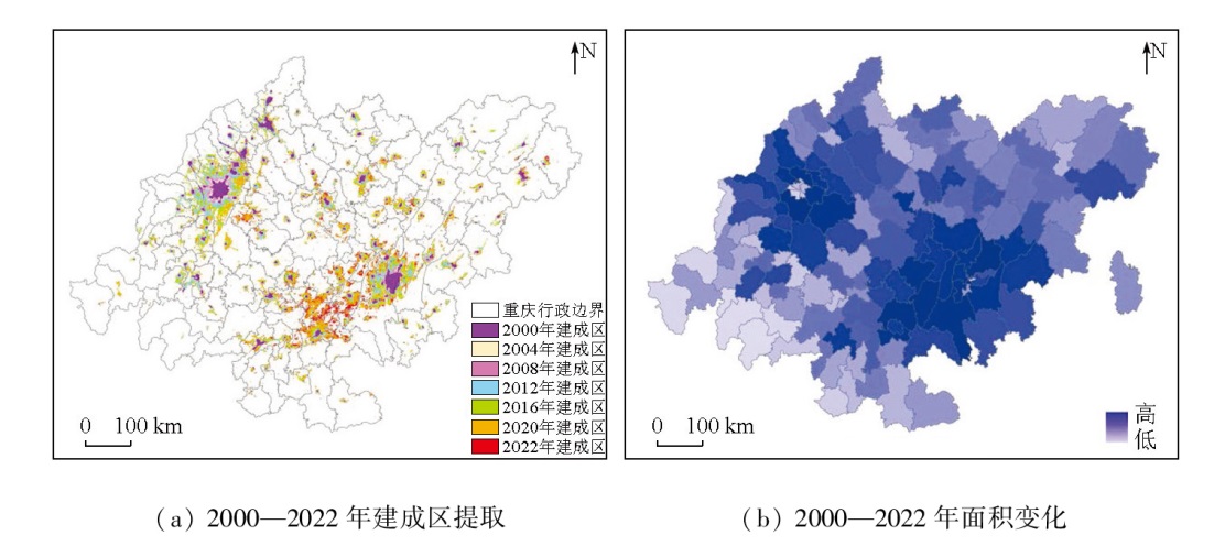
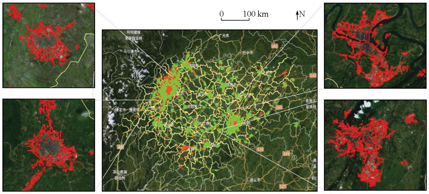
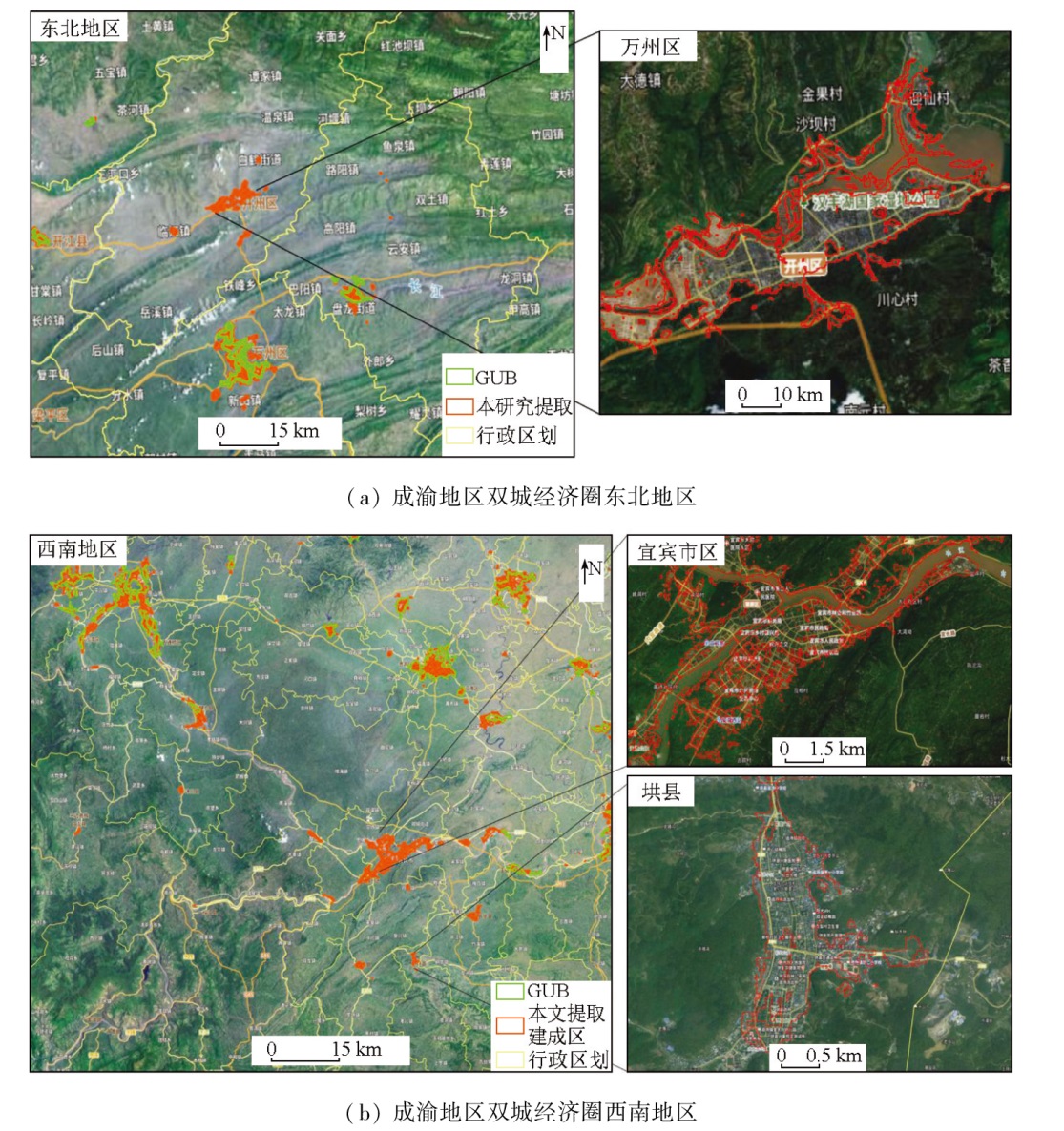
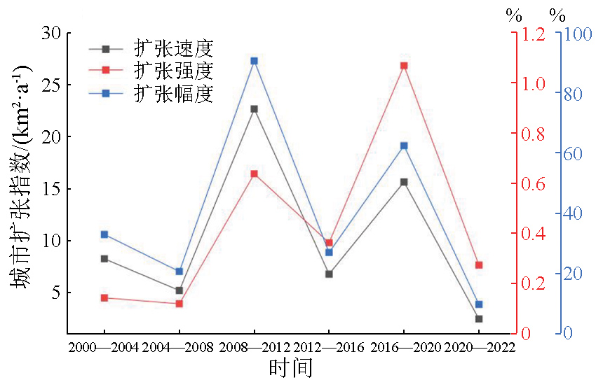
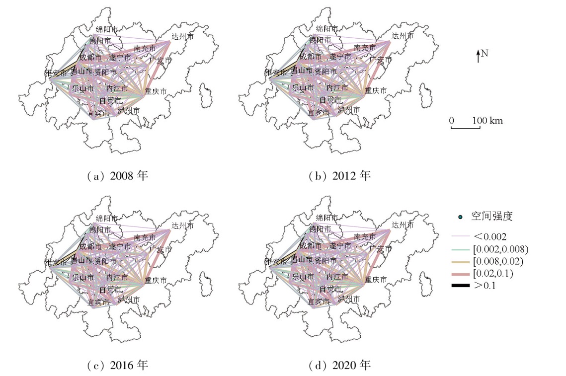
Understanding the characteristics of urban expansion and corresponding spatial changes serves as a prerequisite for optimizing urban spatial structure and resisting disorderly urban land expansion. This study focuses on the Chengdu-Chongqing economic circle. Using multi-source data fusion, this study extracted information on urban built-up areas from 2000 to 2020. From the aspects of urban expansion characteristics, spatial changes, and intercity spatial interaction intensity, this study analyzed the spatiotemporal evolution during urban expansion at both the regional and county scales. The results indicate that incorporating impervious surface information into multi-source data fusion improved the information extraction accuracy of built-up areas, achieving an overall classification accuracy of 98% and an average Kappa coefficient of 0.75. Urban expansion from 2000 to 2020 transitioned from low to medium-high speed and then to low speed. The dominant expansion type was edge expansion, accompanied by decreased spatial compactness. Within the Chengdu-Chongqing economic circle, the strongest spatial interaction intensity occurred between Chengdu and Chongqing. The urban spatial pattern exhibited a “dual cores with two wings” pattern, highlighting the pivotal role of Chengdu and Chongqing in driving the development of surrounding cities. These findings reveal the urban development patterns and spatial change characteristics within the Chengdu-Chongqing economic circle. They will facilitate the rational optimization of land use and territorial spatial patterns, promoting coordinated urban-rural development.
Zhang Y, Zheng F J, Liu Y F, et al. Extracting urban built-up area based on impervious surface area and POI data[J]. Scientia Geographica Sinica, 2022, 42(3):506-514.
doi: 10.13249/j.cnki.sgs.2022.03.015
[2]
Li G, Fang C, Li Y, et al. Global impacts of future urban expansion on terrestrial vertebrate diversity[J]. Nature Communications, 2022, 13(1):1628.
doi: 10.1038/s41467-022-29324-2
pmid: 35338145
The Provincial Party Committee and the provincial government issued the Outline of the Strategic Plan for the Construction of Beautiful Sichuan (2022-2035) - Sichuan Provincial People’s Government Website [EB/OL].[2024-01-01]. https://www.sc.gov.cn/10462/10464/10797/2022/8/29/493ddce2b-17f47fb9a2dd951abe0cb96.shtml.
Notice of Chongqing Municipal People’s Government on Issuing the 14th Five-Year Plan for the Protection and Utilization of Natural Resources of Chongqing (2021-2025).[2024-01-01]. https://www.cq.gov.cn/zwgk/zfxxgkml/szfwj/xzgfxwj/szf/202201/t20220124_10360585.html.
Chen X X. Urban land expansion identification and spatial distribution characteristics of Wuhan city using DMSP/OLS nighttime light data[J]. Journal of Southwest China Normal University (Natural Science Edition), 2019, 44(1):70-78.
Wang M, Li J B, Liang L L, et al. Comprehensive analysis of the urban build-up area extraction based on night light data in Changsha[J]. Journal of Natural Science of Hunan Normal University, 2021, 44(4):45-52.
[7]
Xu P, Jin P, Cheng Q. Monitoring regional urban dynamics using DMSP/OLS nighttime light data in Zhejiang Province[J]. Mathematical Problems in Engineering, 2020, 2020:9652808.
Liu Q Y, Fan J F, Chen Z, et al. Expansion analysis of Chengdu-Chongqing urban agglomeration under nighttime light remote sensing data consistency correction[J]. Science of Surveying and Mapping, 2022, 47(6):99-108.
Tang X, Tang J, Li W B, et al. Extraction of built-up area based on Luojia 1-01 combined with multi source data[J]. Remote Sensing Information, 2023, 38(1):78-87.
Yin X, Wei H, Li Y R. Identification and spatio-temporal variation of county towns’built-up area of China based on impervious surface dataset[J]. Geographical Research, 2023, 42(6):1492-1505.
Li G D, Qi W. Impacts of construction land expansion on landscape pattern evolution in China[J]. Acta Geographica Sinica, 2019, 74(12):2572-2591.
doi: 10.11821/dlxb201912011
Zhang Y P, Zhang P, Sun D F, et al. Analysis of urban construction land expansion pattern and scale system in Chengdu-Chongqing urban agglomeration[J]. Bulletin of Surveying and Mapping, 2020(7):103-107.
doi: 10.13474/j.cnki.11-2246.2020.0223
Wang Y N, Su M M, Wang Y P. Spatial and temporal characteristics and regional differences of urban expansion in the Yellow River Basin:Based on compartive analysis of resource-based and non-resource-based cities[J]. Agricultural resources and Regionalization in China, 2024, 45(6):223-233.
Lin Q X, Lin Y H, Zhen S Y, et al. Expansion law of construction land and its spatial autocorrelation analysis with road network:Taking Fuzhou as an example[J]. Science Technology and Engineering, 2023, 23(7):3001-3010.
[15]
Huang X, Li J, Yang J, et al. 30 m global impervious surface area dynamics and urban expansion pattern observed by Landsat satellites:From 1972 to 2019[J]. Science China Earth Sciences, 2021, 64(11):1922-1933.
[16]
Gong P, Li X, Wang J, et al. Annual maps of global artificial impervious area (GAIA) between 1985 and 2018[J]. Remote Sensing of Environment, 2020, 236:111510.
[17]
Li X, Zhou Y, Zhao M, et al. A harmonized global nighttime light dataset 1992-2018[J]. Scientific Data, 2020, 7(1):168.
doi: 10.1038/s41597-020-0510-y
pmid: 32499523
[18]
Li X, Gong P, Zhou Y, et al. Mapping global urban boundaries from the global artificial impervious area (GAIA) data[J]. Environmental Research Letters, 2020, 15(9):094044.
Xu Z N, Gao X L. A novel method for identifying the boundary of urban built-up areas with POI data[J]. Acta Geographica Sinica, 2016, 71(6):928-939.
doi: 10.11821/dlxb201606003
Zheng H H, Gui Z P, Li F, et al. Urban built-up area extraction method based on nighttime light images and point of interest data[J]. Geography and Geo-Information Science, 2019, 35(2):25-32.
Ma X, He S M, Huang T T, et al. Analysis of spatial-temporal pattern characteristics and driving factors of urban land expansion:Taking central plains city cluster as an example[J]. Ecological Economy, 2020, 36(3):105-111,167.
Zhang N, Zhang H X, Li A Q. Analysis of urban expansion characteristics and driving force analysis of Taiyuan City based on night light images[J]. Bulletin of Surveying and Mapping, 2022(11):79-83,105.
doi: 10.13474/j.cnki.11-2246.2022.0329
Hu M M, Yan Q W, Li J H. Analyzing the spatio-temporal evolution of urban expansion in the central plains urban agglomeration and its driving force based on DMSP/OLS and NPP/VIIRS nighttime light images[J]. Remote Sensing for Natural Resources, 2024(1):189-199.doi:10.6046/zrzyyg.2022410.
Yu Y, Tong Y, Hu S S, et al. Spatial-temporal evolution of spatial interaction among cities of Wuhan metropolitan area[J]. Resources and Environment in the Yangtze Basin, 2017, 26(11):1784-1794.
Zhao D H, Liu Y, Liu X H. A gravity model-based analysis of the spatial structure of land price in polycentric cities:A case study of Chongqing[J]. Journal of Southwest University (Natural Science Edition), 2017, 39(7):130-135.
Li C, Wang J Z, Liu Y, et al. Spatial-temporal evolution characteristics of urban expansion in Chengdu-Chongqing twin-city economic circle[J]. Modern Urban Research, 2023(11):34-41,50.
Liu X B, Wang H L, Liu Y, et al. Characteristics and driving mechanism of central city spatial expansion pattern of Chengdu-Chongqing urban agglomeration[J]. Journal of Chongqing Normal University (Natural Science Edition), 2024, 41(3):121-132.
 2025, Vol. 37
  ), 朱诗柔1(