Identification of landslide hazards based on multi-source remote sensing technology:A case study of the Changli area in Hunan Province
ZHANG Lijun1,2,3(), HE Sirui2, ZHANG Jiandong2(), PENG Guangxiong2, XU Zhibin1, XIE Jiancheng1, TANG Kai1, BU Jiancai1
1. Hunan Remote Sensing Geological Survey and Monitoring Institute, Changsha 410015, China 2. Key Laboratory of Metallogenic Prediction of Nonferrous Metals and Geological Environment Monitor (Central South University), Ministry of Education, Changsha 410083, China 3. Hunan Key Laboratory of Remote Sensing Monitoring of Ecological Environment in Dongting Lake Area, Hunan Natural Resources Affairs Center, Changsha 410004, China
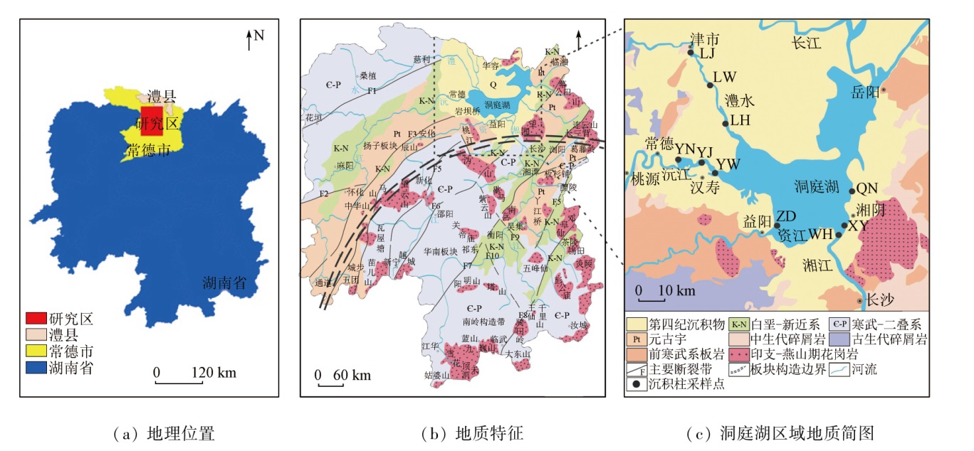
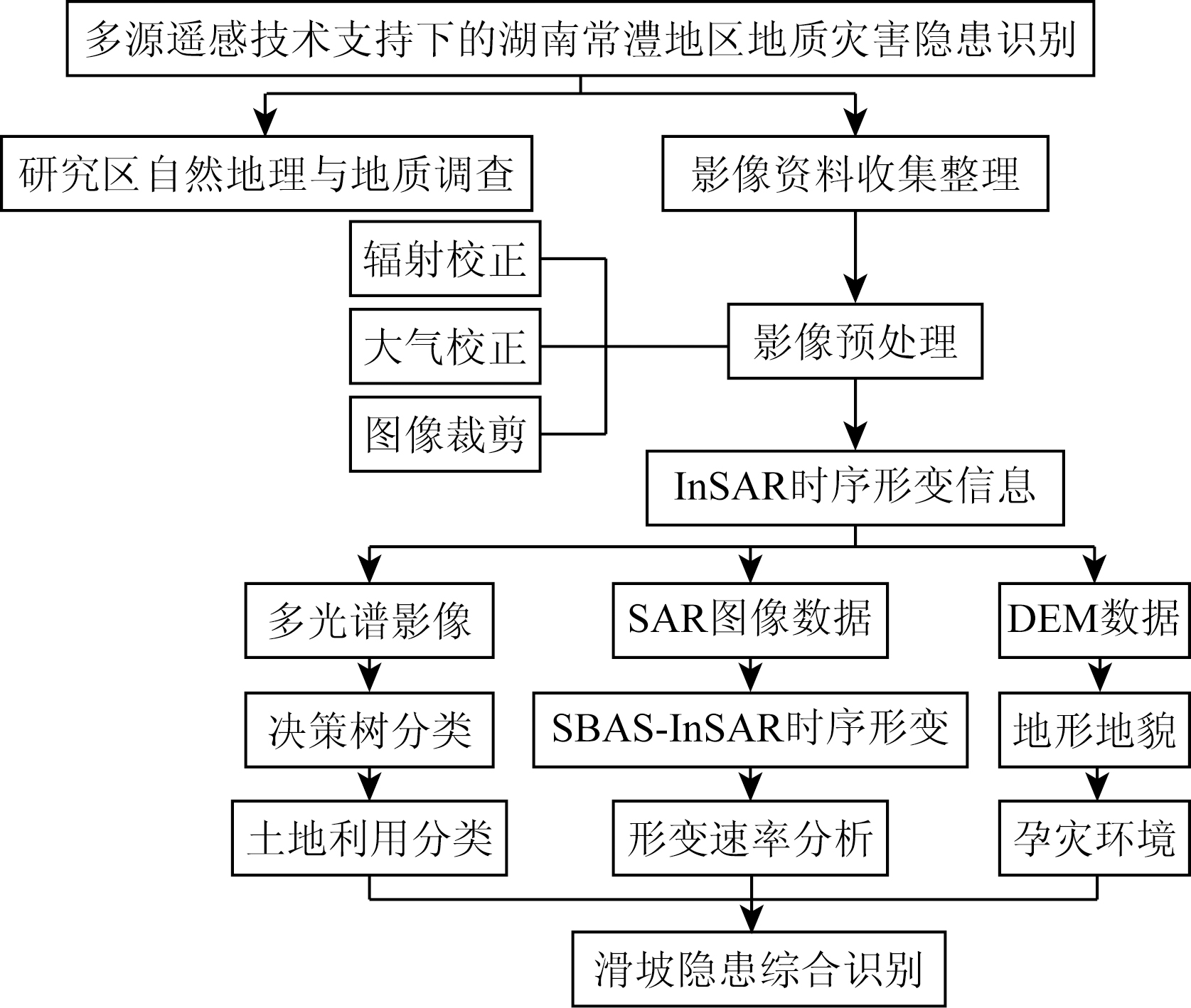
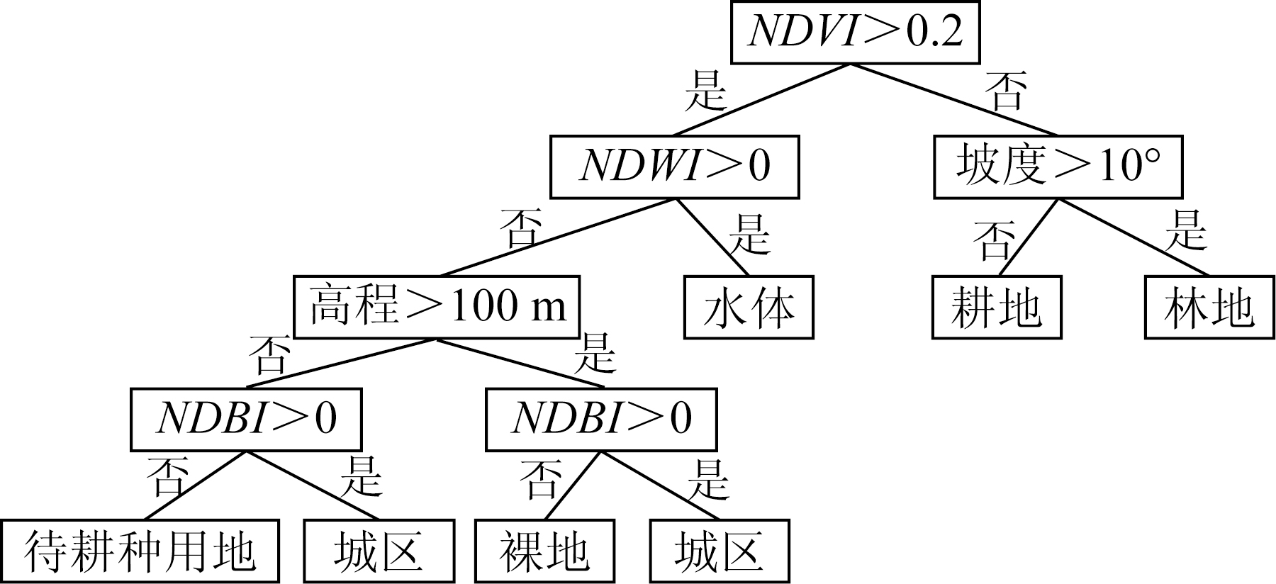
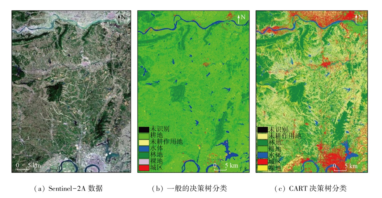
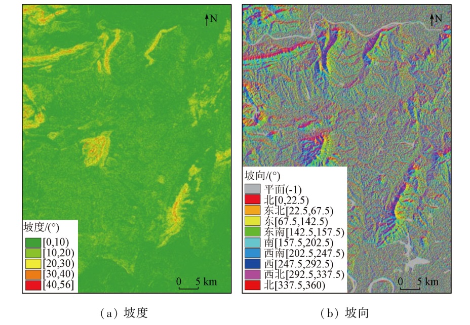
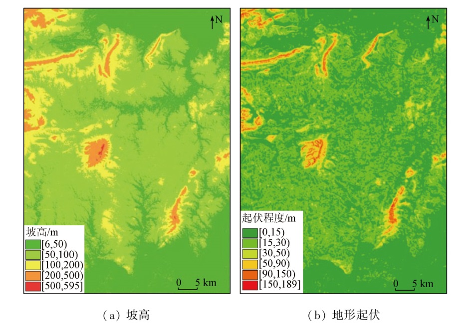
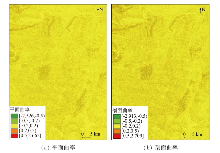
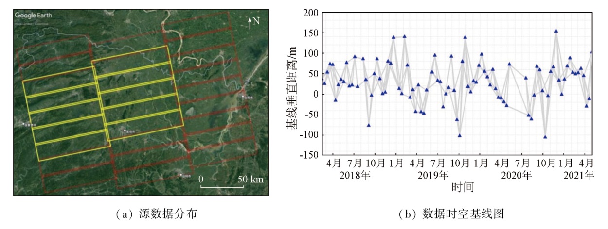
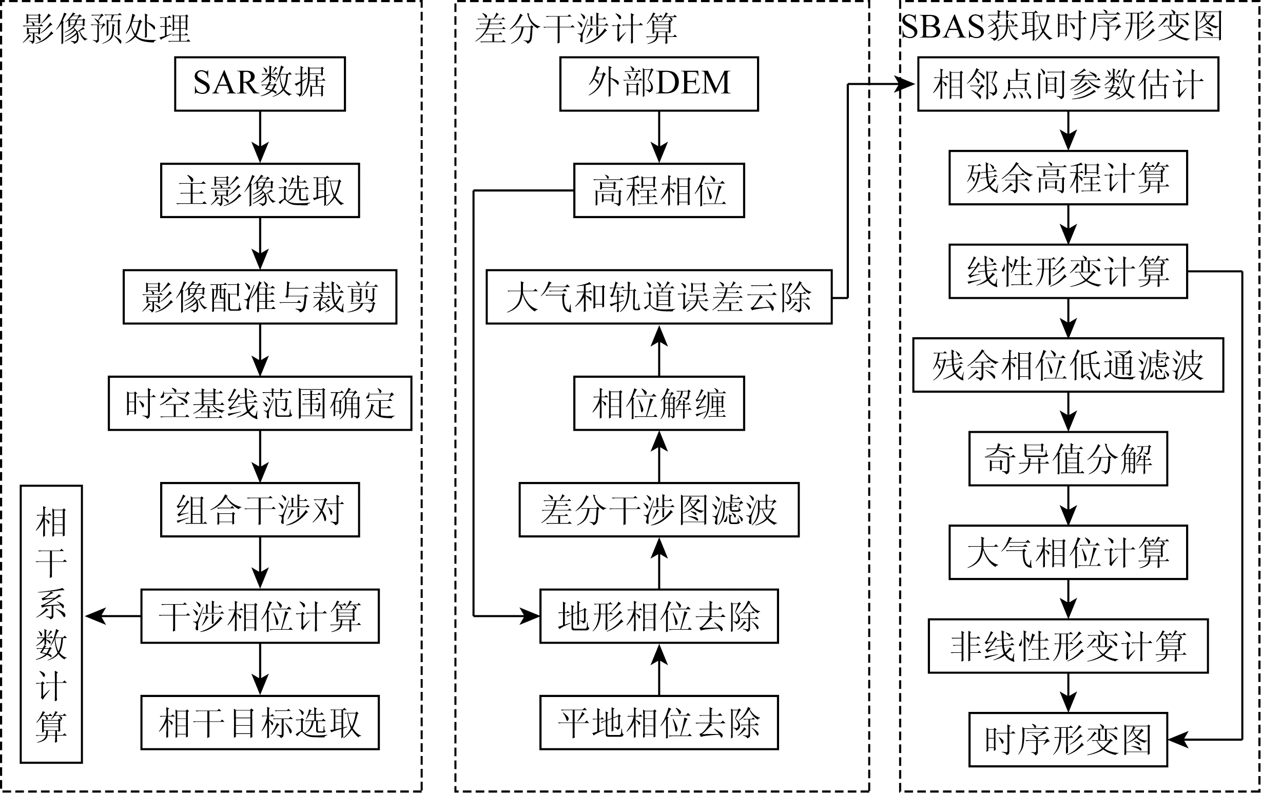
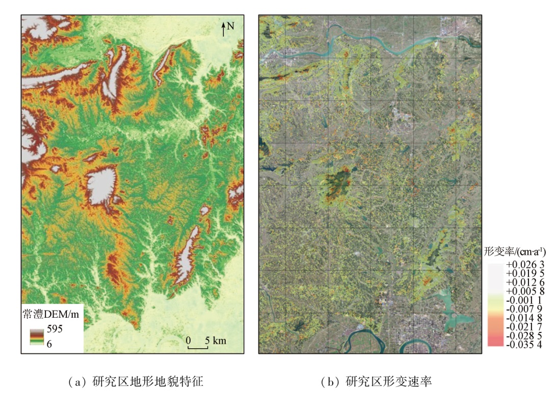
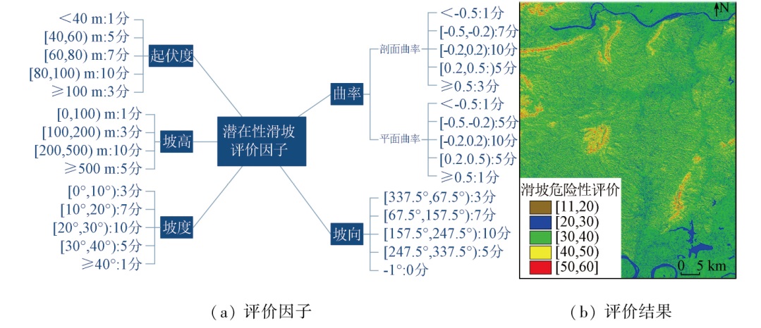
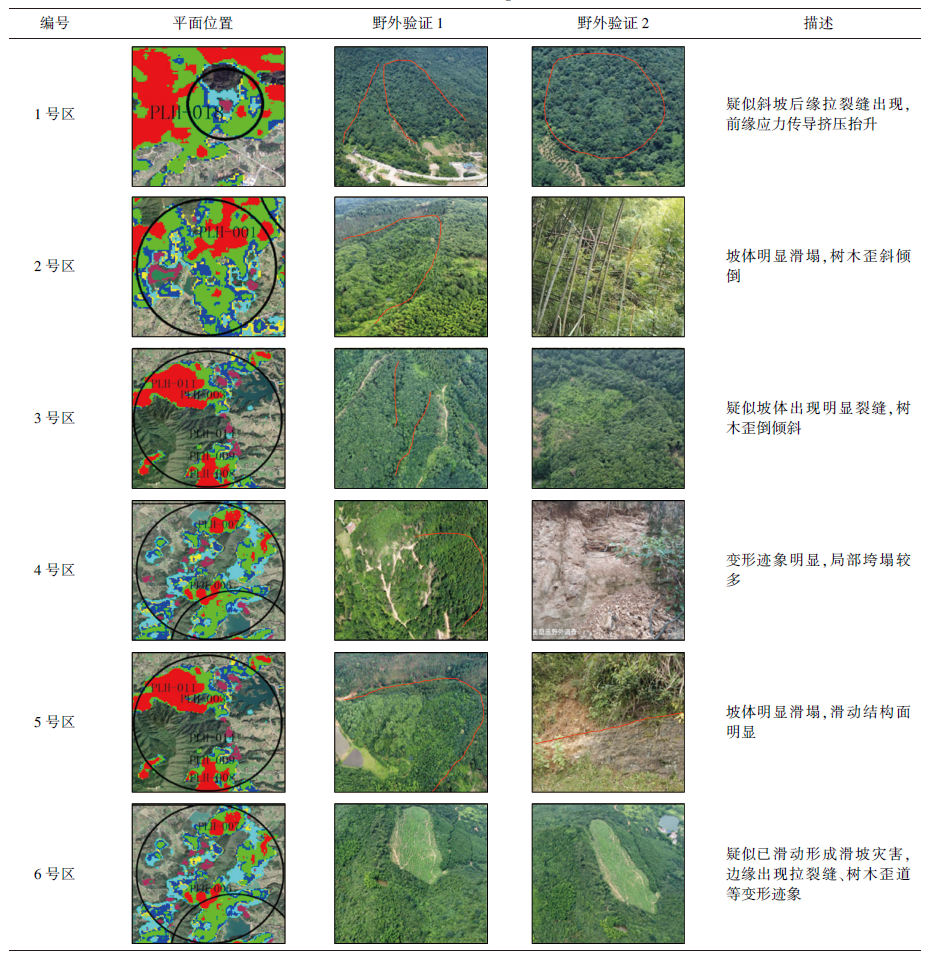
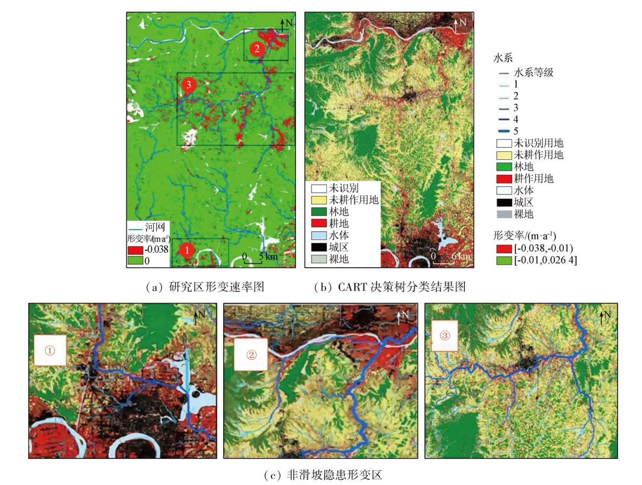
Due to the intricate geographical and geological environment, the mountainous-hilly area of Changli in northern Hunan Province is challenged by numerous, widespread, scattered, and frequent landslide hazards, which constitute the most significant geologic hazard that causes casualties and economic losses. The multi-source remote sensing technology integrating InSAR, optical remote sensing, LiDAR, and GIS is currently a high-feasibility and high-precision landslide hazard identification and monitoring technology, meeting the requirements for macroscale and timeliness. This study identified and extracted landslide hazards in the Changli area based on InSAR deformation rate data, multispectral images, and DEM data. First, two decision tree classification methods were employed to classify the land use types based on multispectral images, facilitating the observation of land use types and their distributions in the Changli area. Then, five topographic factors, including elevation, slope, aspect, undulation, and curvature, were extracted from DEM data to evaluate the landslide risk in the Changli area. Then, five topographic factors, such as elevation, slope, aspect, undulation and curvature, are extracted from DEM data to evaluate the landslide risk in the study area. Furthermore, the time-series surface microdeformation of the Changli area was measured based on SBAS-InSAR technology. Finally, landslide hazards were extracted and delineated in the GIS by combining risk assessment results and deformation rates. Additionally, based on the classification and regression tree (CART) results and the river system distribution in the Changli area, risk inference was conducted on zones with deformation rates exceeding -0.01 m/a except the delineated landslide hazard sites. This study identified several small-scale landslide hazards with high concealment in vegetation-covered and bare zones, delineating their spatial distribution ranges, which covered an area of 0.126 km2. The multi-source remote sensing technology proved effective, demonstrating certain practical application value.
张利军, 贺思睿, 张建东, 彭光雄, 徐质彬, 谢渐成, 唐凯, 卜建财. 多源遥感技术支持下的滑坡地灾隐患识别——以常澧地区为例[J]. 自然资源遥感, 2024, 36(2): 173-187.
ZHANG Lijun, HE Sirui, ZHANG Jiandong, PENG Guangxiong, XU Zhibin, XIE Jiancheng, TANG Kai, BU Jiancai. Identification of landslide hazards based on multi-source remote sensing technology:A case study of the Changli area in Hunan Province. Remote Sensing for Natural Resources, 2024, 36(2): 173-187.
Wang Z H. Remote sensing for landslides in China and its recent progress[J]. Remote Sensing for Land and Resources, 2007, 19(4):7-10.doi:10.6046/gtzyyg.2007.04.02.
[2]
王恭先. 滑坡学与滑坡防治技术[M]. 北京: 中国铁道出版社, 2004.
Wang G X. Landslide science and landslide prevention technology[M]. Beijing: China Railway Publishing House, 2004.
Liao M S, Dong J, Li M H, et al. Radar remote sensing for potential landslides detection and deformation monitoring[J]. National Remote Sensing Bulletin, 2021, 25(1):332-341.
Xue D J, Zhang D H, He Z W, et al. Application of multi-source remote sensing image fusion in geohazard investigation[J]. Remote Sensing Technology and Application, 2011, 26(5):664-669.
[5]
赵英时. 遥感应用分析原理与方法[M]. 北京: 科学出版社, 2003.
Zhao Y S. Principles and methods of remote sensing application analysis[M]. Beijing: Science Press, 2003.
Hua L Z, Cui S H, Li X H, et al. Remote sensing identification of earthquake trigged landsides and their impacts on ecosystem services:A case study of Wenchuan County[J]. Acta Ecologica Sinica, 2008, 28(12):5909-5916.
[7]
Bouali E H, Oommen T, Escobar-Wolf R. Evidence of instability in previously-mapped landslides as measured using GPS,optical,and SAR data between 2007 and 2017:A case study in the Portuguese bend landslide complex,California[J]. Remote Sensing, 2019, 11(8):937.
[8]
Tempa K, Peljor K, Wangdi S, et al. UAV technique to localize landslide susceptibility and mitigation proposal:A case of Rinchending Goenpa landslide in Bhutan[J]. Natural Hazards Research, 2021, 1(4):171-186.
[9]
Dille A, Kervyn F, Handwerger A L, et al. When image correlation is needed:Unravelling the complex dynamics of a slow-moving landslide in the tropics with dense radar and optical time series[J]. Remote Sensing of Environment, 2021, 258:112402.
[10]
李晓英. 常德市土地生态保护研究[D]. 西安: 长安大学, 2008.
Li X Y. Study on the Changde Land Ecological Protection[D]. Xi’an: Changan University, 2008.
[11]
洪明祥. 常德市科学制定"十五" 水利规划[J]. 宏观经济管理, 2001(9):41-42.
Hong M X. Changde scientifically formulates the tenth five-year water conservancy plan[J]. Macroeconomic Management, 2001(9):41-42.
Chen D T, Peng B, Fang X H, et al. Geochemistry of major elements in bed sediments from inlets of the four rivers to Dongting Lake,China[J]. Quaternary Sciences, 2021, 41(5):1267-1280.
Li H. Study on early identification and monitoring of landslide based on optical remote sensing and InSAR technology[D]. Guangzhou: Guangdong University of Technology, 2020.
Liang F, Yang W F, Li R R. Research on surface deformation monitoring in mining area based on SBAS-InSAR technology[J]. Geospatial Information, 2022, 20(11):44-48.
Wan Z Q, Xiao S X. Analysis of formation and chained evolution mechanism of land-slide induced by rainfall[J]. Western China Communications Science & Technology, 2011(1):30-34.
[16]
龚燃. 哨兵-2A光学成像卫星发射升空[J]. 国际太空, 2015(8):36-40.
Gong R. Sentinel-2A satellite launches[J]. Space International, 2015(8):36-40.
[17]
Bar-Hen A, Gey S, Poggi J M. Influence measures for CART classification trees[J]. Journal of Classification, 2015, 32(1):21-45.
[18]
Martin Y E, Franklin S E. Classification of soil- and bedrock-dominated landslides in British Columbia using segmentation of satellite imagery and DEM data[J]. International Journal of Remote Sensing, 2005, 26(7):1505-1509.
Li Q, Zhang J F, Luo Y, et al. Recognition of earthquake-induced landslide and spatial distribution patterns triggered by the Jiuzhaigou earthquake in August 8,2017[J]. Journal of Remote Sensing, 2019, 23(4):785-795.
Tao H J, Yang J, Ye X J. Three dimensional terrain modeling method with creator software based on the ASTER remote sensing data[J]. Computer Knowledge and Technology, 2011, 7(17):4152-4154.
Hui F M, Tian Q J, Li Y C. Production and accuracy assessment of DEM from ASTER stereo image data[J]. Remote Sensing Information, 2004, 19(1):14-18,63.
[22]
张帆宇. 积石峡水电站坝后Ⅰ号滑坡演化过程及稳定性研究[D]. 兰州: 兰州大学, 2007.
Zhang F Y. Study on evolution process and stability of the No.1 landslide at the downstream of the Jishxia hydropower station[D]. Lanzhou: Lanzhou University, 2007.
Zhang F Y, Liu G, Chen W W, et al. A study of landslide susceptibility mapping based on factor analysis and bivariate statistics-With a case study in Longnan Area of national highway 212[J]. Advances in Earth Science, 2008, 23(10):1037-1042.
Li H P. Research on influence of DEM resolution on extraction of terrain factors[J]. Geomatics & Spatial Information Technology, 2021, 44(10):183-188.
[25]
荀张媛. SAR与光学遥感融合在滑坡识别与监测中的应用[D]. 西安: 长安大学, 2020.
Xun Z Y. Landslide identification and monitoring with the fusion of SAR and optical remote sensing[D]. Xi’an: Changan University, 2020.
[26]
Niraj K C, Gupta S K, Shukla D P. Kotrupi landslide deformation study in non-urban area using DInSAR and MTInSAR techniques on Sentinel-1 SAR data[J]. Advances in Space Research, 2022, 70(12):3878-3891.
[27]
Zhang T, Xie S, Fan J, et al. Detection of active landslides in southwest China using Sentinel-1 and ALOS-2 data[J]. Procedia Computer Science, 2021, 181:1138-1145.
[28]
Ferretti A, Prati C, Rocca F. Permanent scatterers in SAR interferometry[J]. IEEE Transactions on Geoscience and Remote Sensing, 2001, 39(1):8-20.
[29]
高腾飞. InSAR技术在地面沉降监测中的应用研究[D]. 青岛: 山东科技大学, 2018.
Gao T F. Research on the application of InSAR technology in land subsidence monitoring[D]. Qingdao: Shandong University of Science and Technology, 2018.
[30]
Berardino P, Fornaro G, Lanari R, et al. A new algorithm for surface deformation monitoring based on small baseline differential SAR interferograms[J]. IEEE Transactions on Geoscience and Remote Sensing, 2002, 40(11):2375-2383.
[31]
Ferretti A, Fumagalli A, Novali F, et al. A new algorithm for processing interferometric data-stacks:SqueeSAR[J]. IEEE Transactions on Geoscience and Remote Sensing, 2011, 49(9):3460-3470.
Wang L Y. Study on key technologies of deformation monitoring in mining areas based on phase and intensity information of SAR images[J]. Acta Geodaetica et Cartographica Sinica, 2022, 51(9):1980.
doi: 10.11947/j.AGCS.2022.20210055
 2024, Vol. 36
  ), 贺思睿2, 张建东2(