A remote sensing methodology for predicting geothermal resources in the Wugongshan uplift zone
CHEN Yan1,2(), YUAN Jing1,2,3, TANG Chunhua1,2(), SUN Chao1,2, TANG Xiao1,2, WANG Mingyou1,2
1. Basic Geological Survey Institute of Jiangxi Geological Survey and Exploration Institute, Nanchang 330030, China 2. Jiangxi Non-ferrous Geology and Mineral Exploration and Development Institute, Nanchang 330030, China 3. School of Earth Sciences and Resources, China University of Geosciences (Beijing), Beijing 100083, China
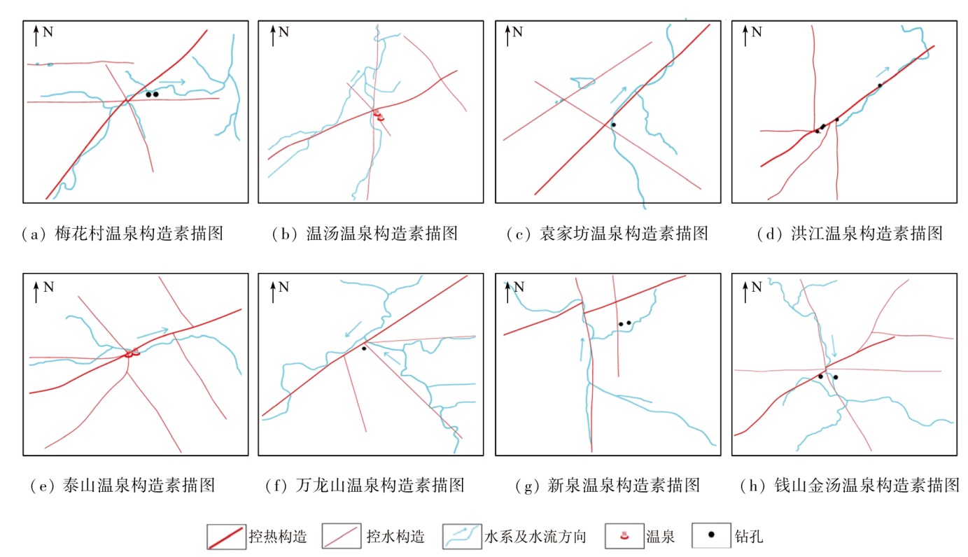
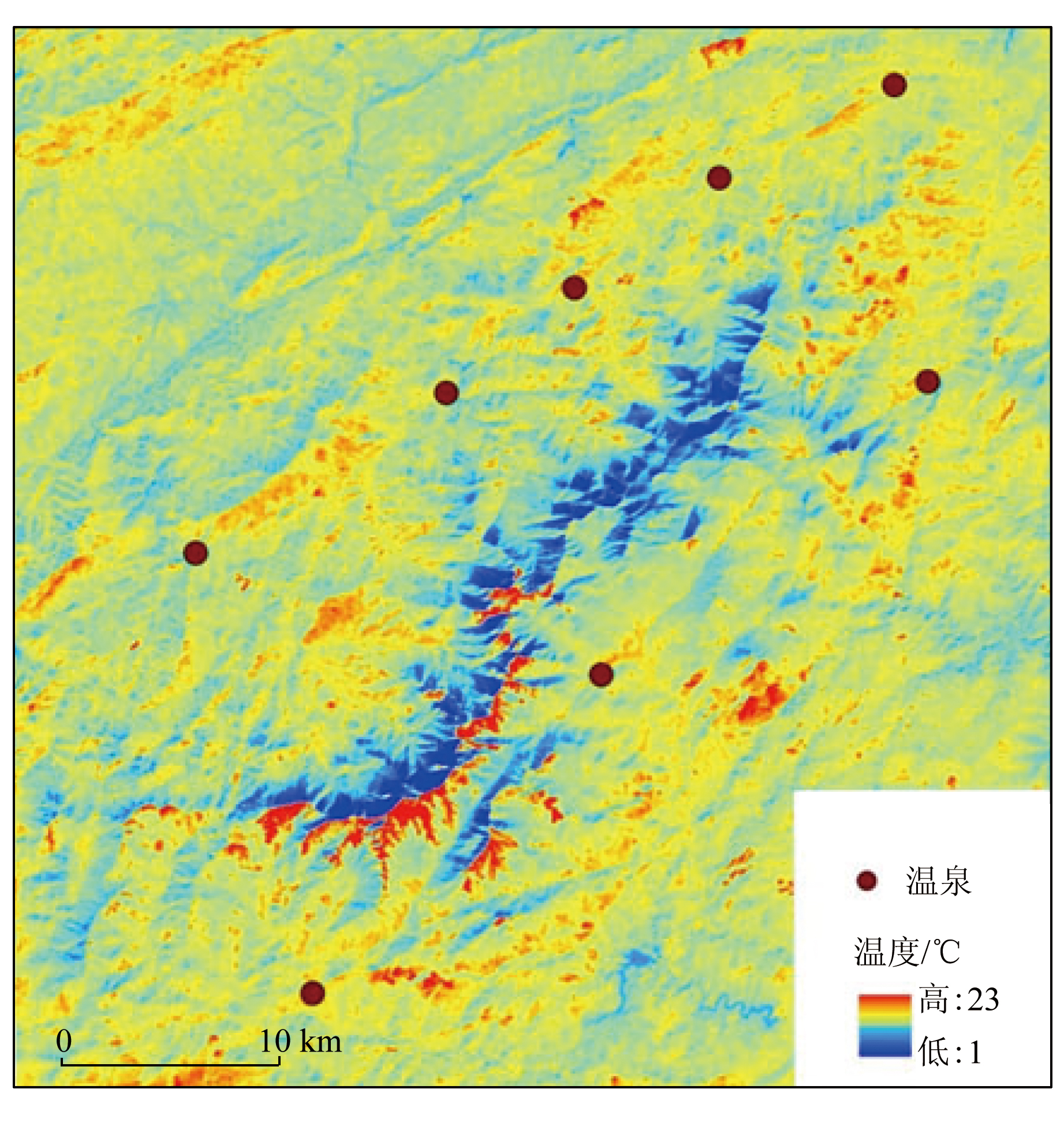
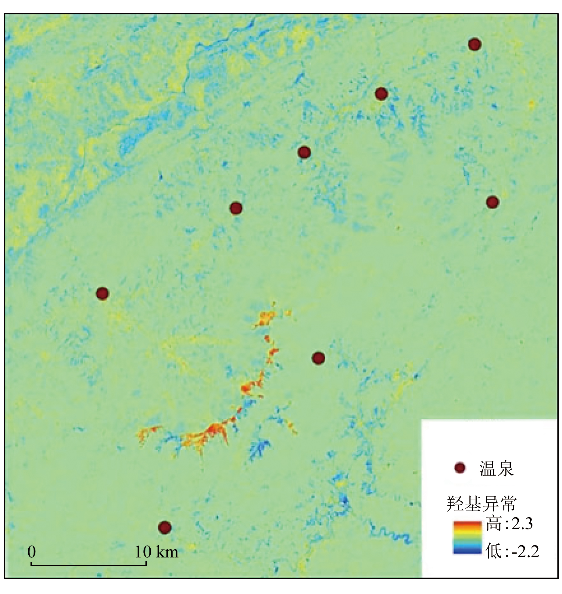
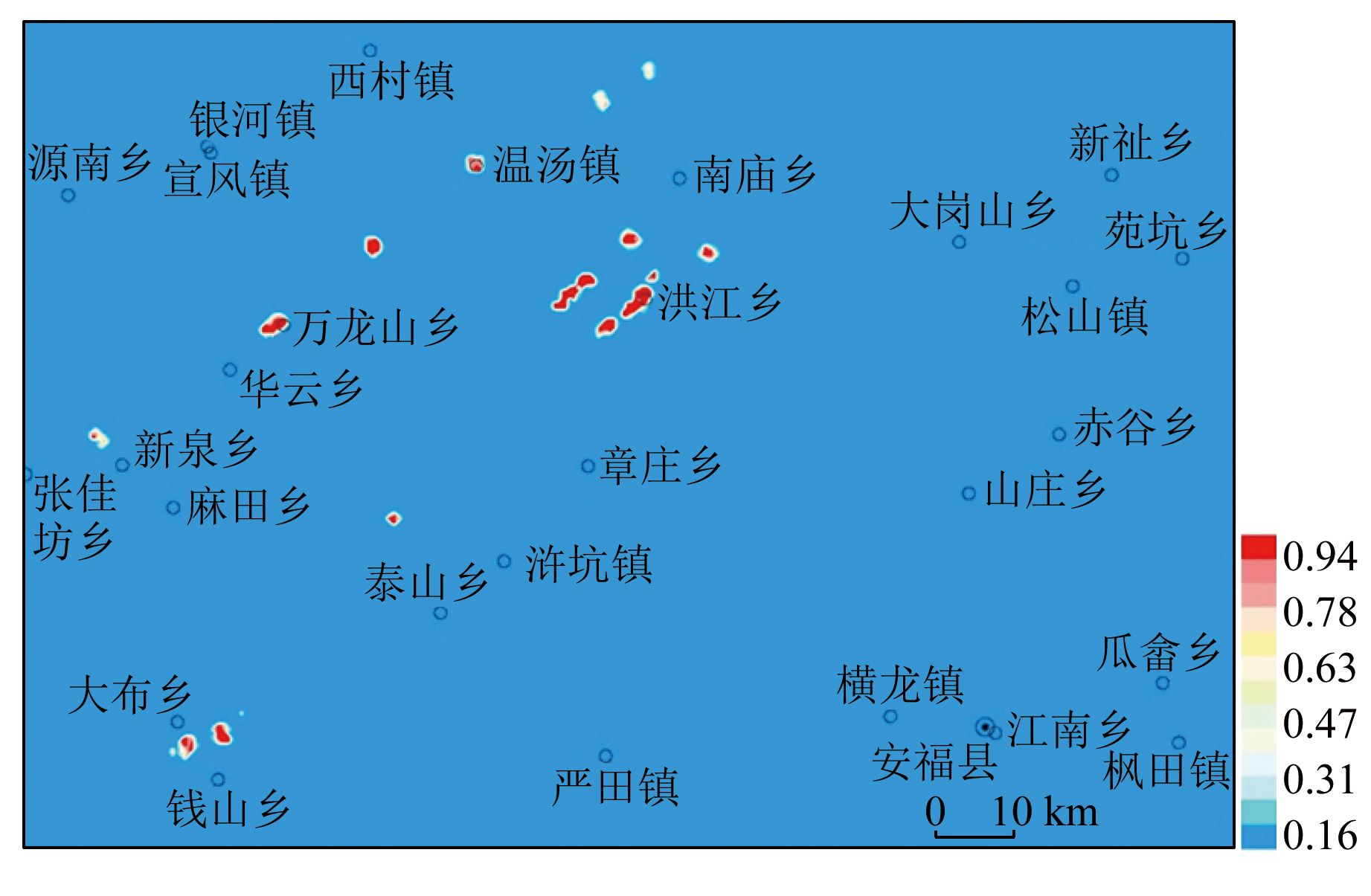
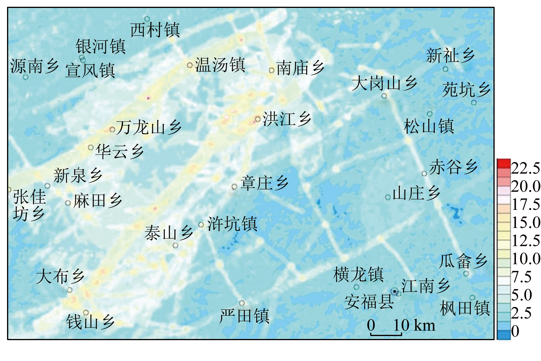
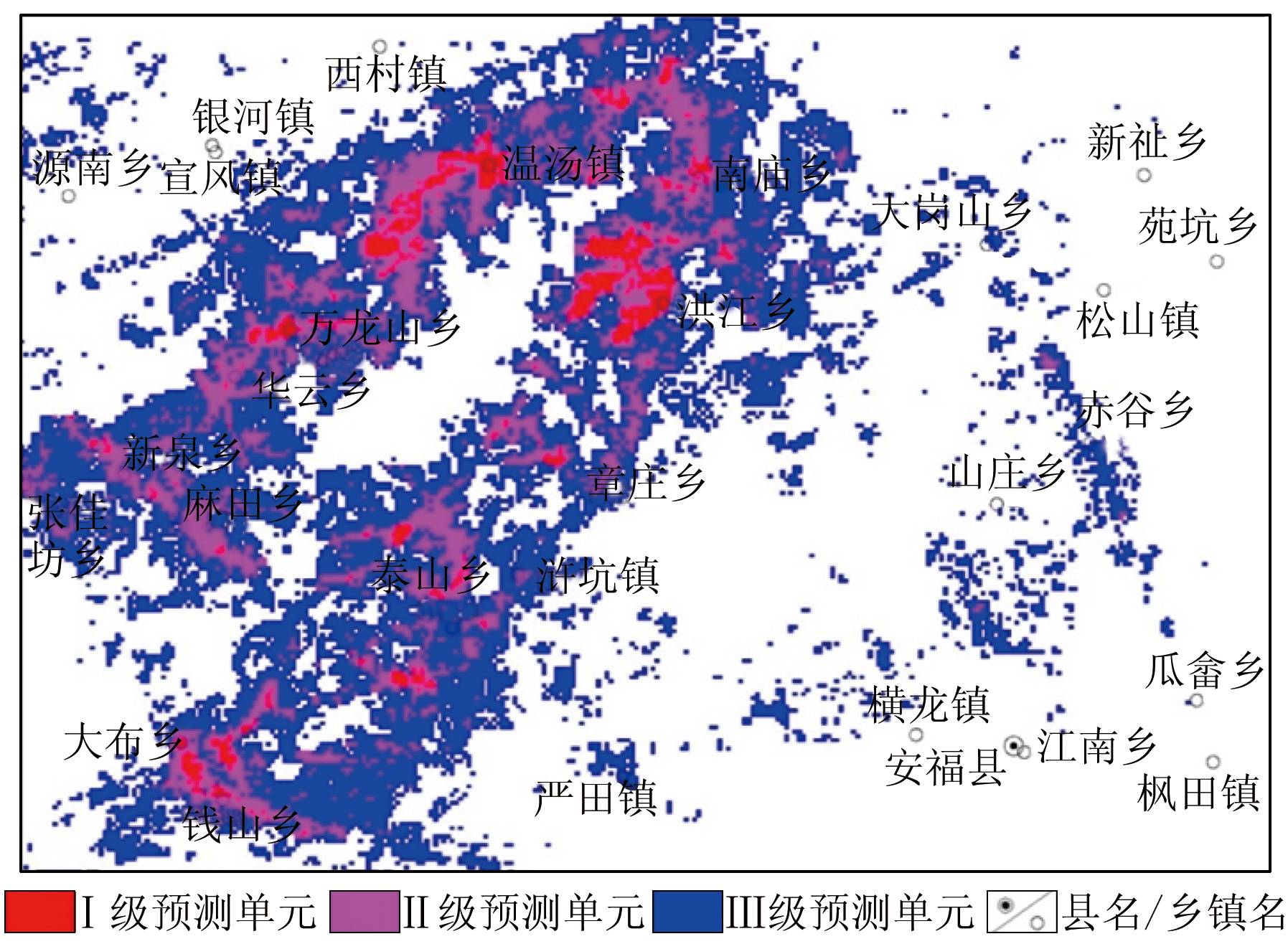
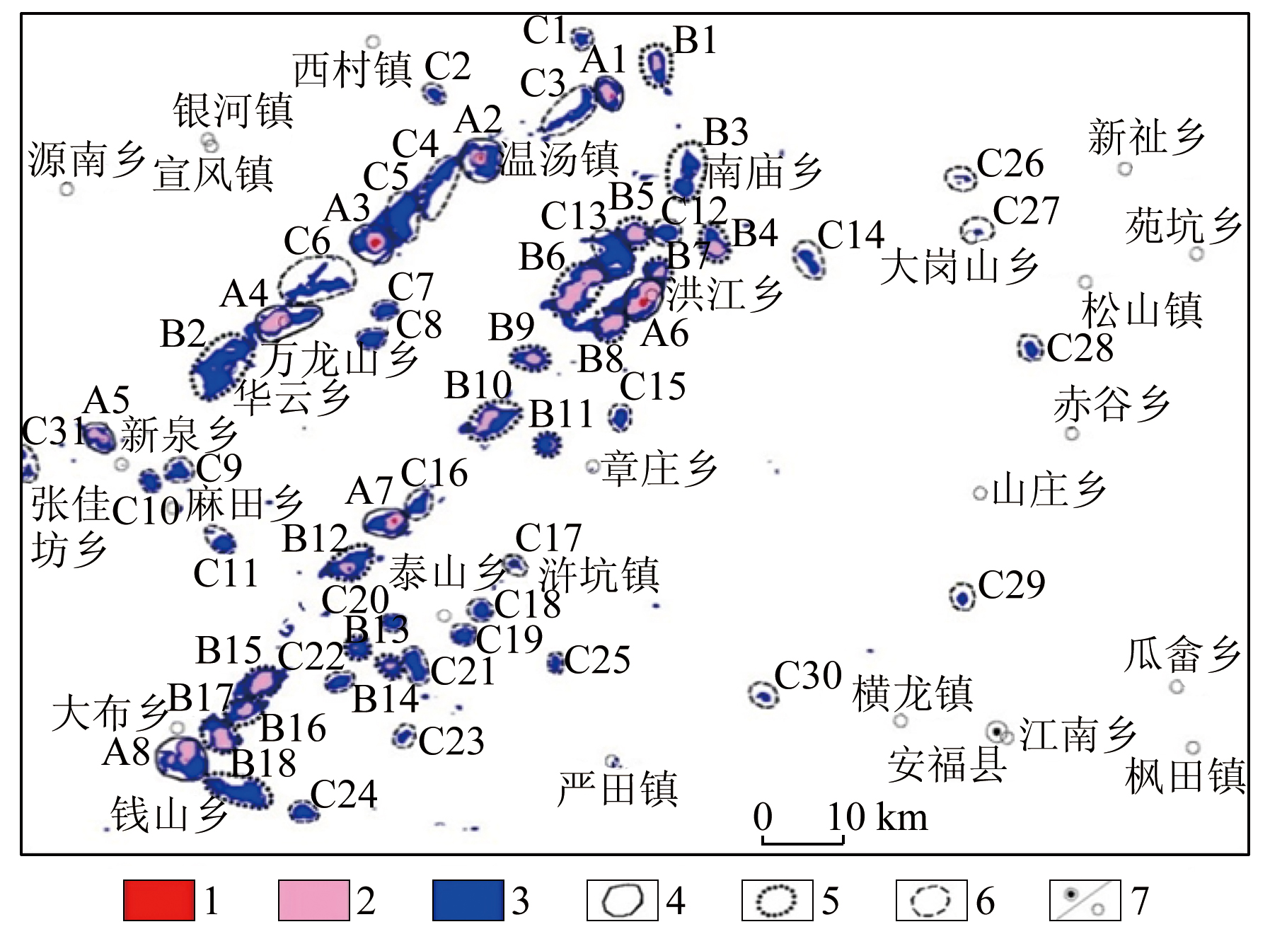
Based on thermal infrared and multispectral remote sensing data, this study analyzed the thermal spring-related structures interpreted from remote sensing images. Thermal springs crop out at the intersections of asterisk- and lambda-shaped structures, with asterisk-shaped structures exhibiting more favorable conditions. By delving into remote sensing characteristics related to thermal springs, this study presented remote sensing factors like surface temperature, hydroxyl anomaly, soil moisture, hydrographic net, and elevation. Using mathematical geostatistics and prediction methods based on geographical information system (GIS), including the weight of evidence, prospecting information content method, and feature factor method, this study analyzed the geological, remote sensing, and geophysical factors related to thermal springs for mathematical geostatistics and prediction. The comprehensive analysis reveals 57 favorable geothermal areas, including 8 in category A, 18 in category B, and 31 in category C. All the category-A favorable geothermal areas include known geothermal sites, and one category-B favorable area reveals a 51.6 ℃ thermal spring, suggesting reliable prediction results. The methodology of this study provides a new approach for geothermal resource prediction.
Yang J Y, Wen X W, Tan H B. Land surface temperature using remote sensing data inversion and prediction of geothermal anomaly area in Nimu,Xizang(Tibet)[J]. Geological Review, 2021, 67(6):1770-1779.
Xiong Y Z, Chen F, Huang S P. Application of remote sensing technique to the identification of geothermal anomaly in Tengchong area,southwest China[J]. Journal of Chengdu University of Technology(Science &Technology Edition), 2016, 43(1):109-118.
Xin L, Liu X X, Zhang B. Land surface temperature retrieval and geothermal resources prediction by remote sensing image:A case study in the Shijiazhuang area,Hebei Province[J]. Journal of Geomechanics, 2021, 27(1) :40-51.
He J X, Sun H Z, Li W Q, et al. Land surface temperature retrieval in eastern Liaoning geothermal area based on thermal infrared remote sensing data[J]. Journal of Jilin University(Information Science Edition), 2018, 36(1):62-68.
Sun H Z. Land surface temperature retrieval based on thermal infrared remote sensing data and research on the exploring methodology of geothermal resources in Dandong-Liaoyang[D]. Changchun: Jilin University, 2018.
Liu X C, Jiang Y, Liu X Y, et al. Application of Landsat ETM+ remote sensing data in searching geothermal field Linyi City[J]. Shangdong Land Resources, 2015, 31(5):76-81.
Yan B Z, Qiu S W, Xiao C L, et al. potential geothermal fields remote sensing identification in Changbai Mountain Basalt area[J]. Journal of Jilin University(Earth Science Edition), 2017, 47(6):1819-1828.
[8]
张福坤. 长白山地区地热资源潜力预测遥感研究[D]. 长春: 吉林大学, 2016.
Zhang F K. Remote prediction of geothermal resource potential in the Changbai Mountain area[D]. Changchun: Jilin University, 2016.
Zhang Y J, Yu H, Li J M, et al. Prediction models of deep hydrothermal geothermal potential areas based on GIS:A case study of western Anatolia,Turkey[J]. Journal of Jilin University(Information Science Edition), 2016, 46(3):855-864.
Wang M L. Controlling factors of geothermal water in Wugong Mountain area of Jiangxi Province and exploration direction[J]. Science and Technology Innovation Herald, 2018, 15(36):39-40.
Chen Z, Dong Q, Chen J P, et al. Research on quantitative prediction and evaluation of geothermal anomaly area in Qamdo-Nyingchi section of Sichuan-Tibet railway[J]. Remote Sensing Technology and Application, 2021, 36(6):1368-1378.
[14]
翟锡丹. 长白山地区地表温度异常遥感研究[D]. 长春: 吉林大学, 2015.
Zhai X D. Changbai Mountain Area surgace temperature anomaly of remote sensing research[D]. Changchun: Journal of Jilin University, 2015.
Mao K B, Tang H J, Chen Z X, et al. A Split-window algorithm for retrieving land-surface temperature from ASTER data[J]. Remote Sensing Information, 2006, 21(5):7-11.
Mao K B, Shi J C, Qin Z H, et al. A four-channel algorithm for retrieving land surface temperature and em issivity from ASTER data[J]. Journal of Remote Sensing, 2006, 10(4):593-599.
Sun J, Zhao P, Ye Q. A split-window algorithm for retrieving land surface temperature from ASTER data[J]. Remote Sensing Technology and Application, 2012, 27(5) :728-734.
Gao M F, Qin Z H. The validation of chinese land surface temperature products retrieved from moderate resolution imaging spectroratiometer[J]. Remote Sensing for Land and Resources, 2006, 18(3):15-18.doi:10.6046/gtzyyg.2006.03.04.
Wang M L. Analysis on geothermal geological characteristics and exploration direction of Xinquan in Luxi County,Jiangxi Province[J]. Chinese Science and Technology, 2018(20):136-137.
[21]
辛田军. 江西省温汤地热田地热水成因机理及开发利用前景[D]. 南京: 南京大学, 2016.
Xin T J. Wentang geothermal field and water reaources formation machanism and utilization prospect research in Jiangxi Province[D]. Nanjing: Nanjing University, 2016.
Hui A D, Zhang G J, Zhao J, et al. Study on remote sensing monitoring model of groundwater level in Aeolian desertification areas:A case study of Mu Us Aeolian desertification areas,China[J]. Agricultural Research in the Arid Areas, 2010, 28(6):196-200.
Luo H, Wang H, Shi C H. Retrieving groundwater in Yellow River Delta area using remote sensing[J]. Remote Sensing for Land and Resources, 2013, 25(3):145-152.doi:10.6046/gtzyyg.2013.03.24.
Yang S C, Shen Y J, Guo Y, et al. Monitoring soil moisture by apparent thermal inertia method[J]. Chinese Journal of Eco-Agriculture, 2011, 19(5):1157-1161.
Zhao X, Wang P, Ma L. Extraction of soil moisture information based on remote sensing data and analysis of influencing factors[J]. China Sciencepaper, 2019, 14(9):991-997.
Liu Y, Wu L X, Ma B D. Remote sensing monitoring of soil moisture on the basis of TM/ETM+ spectral space[J]. Journal of China University of Mining and Technology, 2013, 42(2):296-301.
Yang J M, Zhang Y J, Chen W, et al. Application for technigue in abstracting:Remote alteration anomalies from ETM+(TM) data in eastern Tianshan,Xinjiang,China[J]. Mineral Deposits, 2002, 21(s1):1225-1227.
Yang J M, Zhang Y J, Chen W, et al. Application of ETM+(TM) remote sensing alteration anomaly extraction technique to Gobi Area,East Tianshan mountains[J]. Mineral Deposits, 2003, 22(3):278-286.
Zhang Y J, Yao F J. Application study of multi-spectral ASTER data for determination of ETM remote sensing anomaly property:Taking Wulonggou region of eastern KumLun moutain range as example[J]. Acta Mineralogica Sinica, 2015, 25(4):963-970.
Zhang Y J, Zeng Z M, Chen W. The methods for extraction of alteration anomalies from the ETM+(TM) data and their application:Method selection and technological flow chart[J]. Remote Sensing for Land and Resources, 2003, 15(2) :44-50.doi:10.6046/gtzyyg.2003.02.11.
Zhang Y J, Zeng Z M, Yao F J. Optimization of multispectral remote sensing anomaliy by spectral angle mapping(SAM)[J]. Acta Mineralogica Sinica, 2015, 35(s1):985.
Kong H, Sun Z H, Shi L, et al. Extracting watershed network from DEM data under ArcGIS software[J]. Digital Technology and Application, 2018, 36(9):76-78.
Luo D Y, Wen X P, Shen P, et al. Information extraction of river networks and determination of drainage area threshold using DEM data[J]. Bulletion of Soil and Water Conservation, 2017, 37(4):189-193.
Wu E Z. Application of evidence weight method based on GIS in mineral resource evaluation[D]. Beijing: China University of Geosciences (Beijing), 2014.
Lei T C, Luo S X, Wang L. Application of weights of evidence method for prediction of W-Sn polymetallic deposits based on multi -source information in Nanling metallogenic belt[J]. Geology and Mineral Resources of South China, 2016, 32(1):34-42.
Fang J, Zhang X D, Zhang D Y, et al. Prediction and evaluation of large scale metallogeny in the Dongxi gold deposit of Anhui Province based on the weights of evidence methodology[J]. East China Geology, 2017, 38(1):37-44.
Liu Y Z, Shen W. Application of the evidence - weight method based on GIS to the prediction of the lead - zinc polymetallic deposit in the Tieli - Ergu area[J]. Geology and Exploration, 2018, 54(1):59-68.
Pu L p, Zhu G Q, Yin Y Q, et al. Principles and application of ore-bearing-grid-cell based Monte-Carlo method for mineral resource potetial assessment combined with prospecting information method[J]. Mineral Resources and Geology, 2016, 30(3):490-495.
Wu C J, Xu D R, Zhou Y C, et al. Metallogenic prognosis for skarn-type deposits based on characteristic analysis in southern Hainan Island[J]. Geotectonica et Metallogenia, 2015, 39(3):528-541.
 2024, Vol. 36
  ), 袁晶1,2,3, 唐春花1,2(