Please wait a minute...
 
自然资源遥感  2024, Vol. 36 Issue (4): 254-259    DOI: 10.6046/zrzyyg.2023152
  技术应用 本期目录 | 过刊浏览 | 高级检索 |
基于L波段差分干涉SAR卫星的安康地区滑坡隐患识别
韩静(), 杨帅, 杨涛, 朱楠男, 马煜栋, 张文龙()
自然资源陕西省卫星应用技术中心,西安 710002
Identification of potential landslide hazards in the Ankang area using L-band differential interferometric SAR satellite
HAN Jing(), YANG Shuai, YANG Tao, ZHU Nannan, MA Yudong, ZHANG Wenlong()
Shaanxi Satellite Application Center for Natural Resources, Xi’an 710002, China
全文: PDF(12403 KB)   HTML  
输出: BibTeX | EndNote (RIS)      
摘要 

2023年4月1日,我国第一组L波段差分干涉SAR卫星(L-band differential interferometric SAR satellite,L-SAR)开始向自然资源领域试推送干涉SAR数据。为验证L-SAR卫星在高植被覆盖区、地形复杂区、长时间基线下的相干性及形变监测应用效果,选取秦巴山地东段安康区域开展滑坡隐患识别。利用L-SAR数据获取研究区形变信息,结合高分辨率光学影像经综合遥感识别,解译研究区内滑坡隐患7处,经野外调查验证,滑坡隐患区域变形迹象与InSAR监测结果一致。研究表明: L-SAR卫星干涉成像能力较强,成像质量高,形变监测效果较好,能够满足高植被覆盖区形变监测需求; 在植被覆盖高的山区,通过L波段SAR数据的DInSAR技术,结合高分辨率光学影像解译的综合遥感识别技术可实现滑坡隐患识别。

服务
把本文推荐给朋友
加入引用管理器
E-mail Alert
RSS
作者相关文章
韩静
杨帅
杨涛
朱楠男
马煜栋
张文龙
关键词 L-SAR滑坡地质灾害隐患InSAR    
Abstract

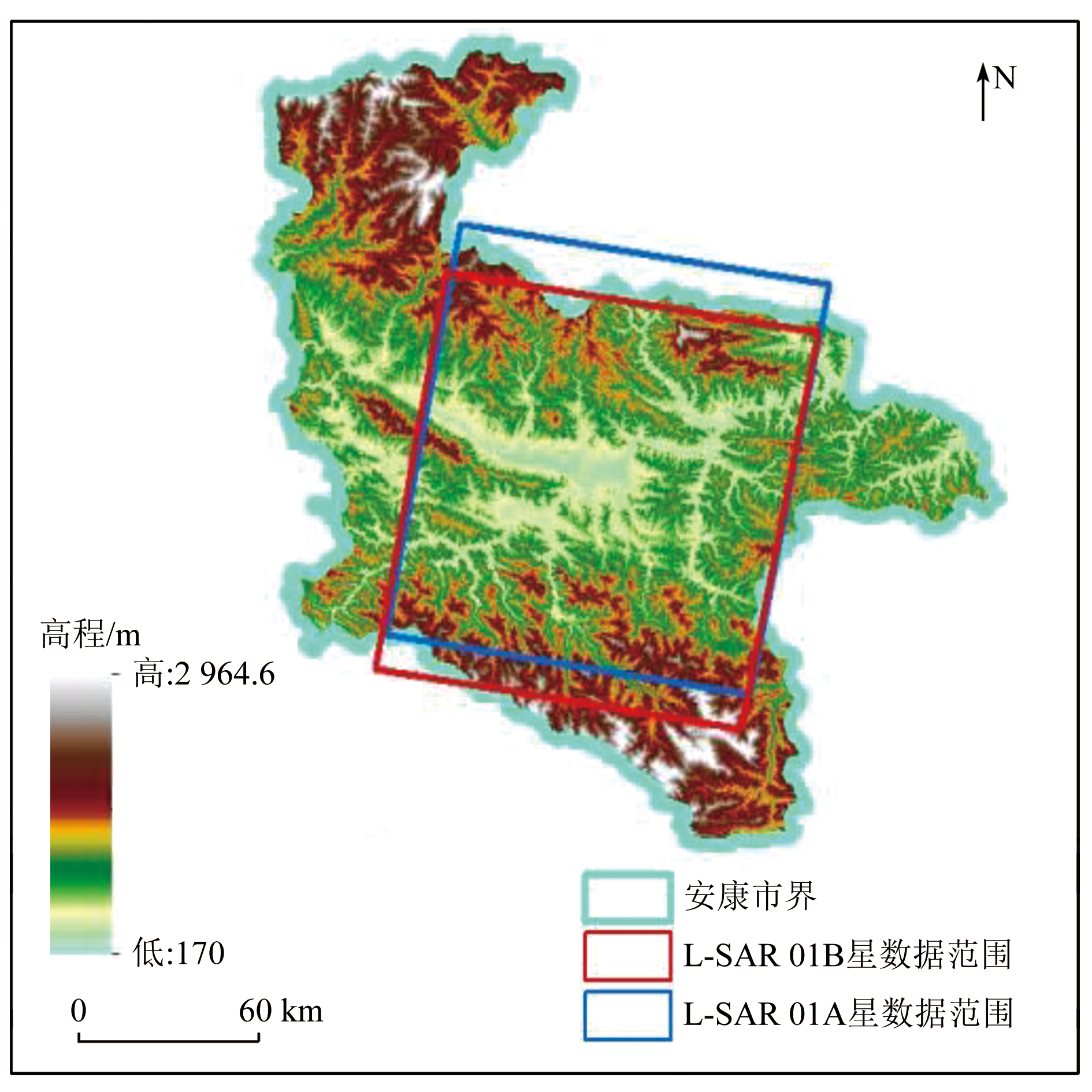
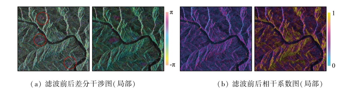
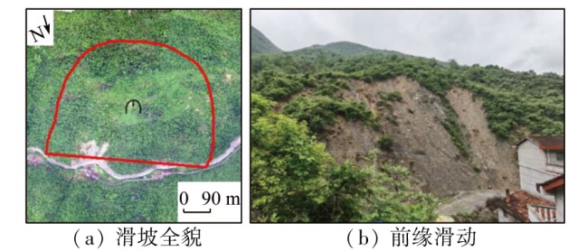
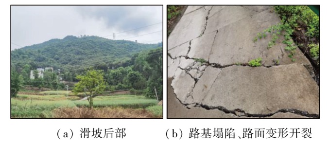
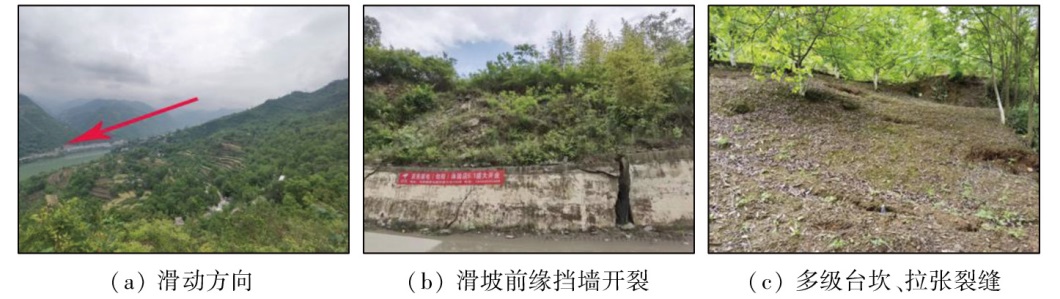
On April 1, 2023, China’s first satellite constellation-L-band differential interferometric Synthetic Aperture Radar (L-SAR)-began to test the distribution of interferometric SAR data for natural resource applications. To evaluate the coherence and effectiveness of deformation monitoring using the L-SAR satellite for areas with high vegetation coverage, complex terrain, and long-term baseline, this study conducted potential landslide hazard identification in the Ankang area in the eastern Qinba Mountain. The deformation information of the study area was extracted using L-SAR data. Using such information, combined with high-resolution optical images for comprehensive remote sensing identification, this study identified seven potential landslide hazards in the study area through interpretation. Field investigation confirmed that the observed deformation signs in potential landslide hazard areas were consistent with the InSAR monitoring results. The study indicates that the L-SAR satellite enjoys a high interference imaging ability, high imaging quality, and effective deformation monitoring, meeting the demand for deformation monitoring in areas with high vegetation coverage. For mountainous areas with high vegetation coverage, the use of L-band SAR data through DInSAR technology, combined with comprehensive remote sensing identification using high-resolution optical imagery, allows for the effective identification of potential landslide hazards.

Key wordsL-SAR    landslide    potential geological hazard    InSAR
收稿日期: 2023-05-23      出版日期: 2024-12-23
ZTFLH:  TP79  
基金资助:陕西省地质灾害综合防治体系建设项目“国产雷达卫星数据地质灾害隐患识别关键技术研究(陕自然资勘发〔2024〕98号)
通讯作者: 张文龙(1982-),男,硕士研究生,高级工程师,主要从事遥感、地质灾害研究。Email: 27860422@qq.com
作者简介: 韩静(1991-),女,硕士研究生,工程师,主要从事InSAR形变监测。Emaill: hanjing_rs@163.com
引用本文:   
韩静, 杨帅, 杨涛, 朱楠男, 马煜栋, 张文龙. 基于L波段差分干涉SAR卫星的安康地区滑坡隐患识别[J]. 自然资源遥感, 2024, 36(4): 254-259.
HAN Jing, YANG Shuai, YANG Tao, ZHU Nannan, MA Yudong, ZHANG Wenlong. Identification of potential landslide hazards in the Ankang area using L-band differential interferometric SAR satellite. Remote Sensing for Natural Resources, 2024, 36(4): 254-259.
链接本文:  
https://www.gtzyyg.com/CN/10.6046/zrzyyg.2023152      或      https://www.gtzyyg.com/CN/Y2024/V36/I4/254
Fig.1  研究区地形及L-SAR 01A,01B星数据范围
项目 参数 项目 参数
轨道类型 准太阳同步近圆
轨道
回归轨道控制
半径
350 m
轨道高度 约607 km 工作频段 L波段
观测范围 85°S-85°N 中心频率 1.26 GHz
回归周期 单星8 d,双星4 d 数传码速率 2×450 Mbps
Tab.1  L-SAR卫星主要参数[12]
Fig.2  滤波前、后相干系数图及差分干涉图
Fig.3  研究区域地表形变与滑坡隐患识别结果
Fig.4  典型滑坡隐患InSAR与光学影像对比图
Fig.5  安坡滑坡隐患野外调查照片
Fig.6  金马塔村滑坡隐患野外调查照片
Fig.7  枣园村滑坡隐患野外调查照片
[1] Li T, Tang X M, Zhou X Q, et al. Lutan-1 SAR main applications and products[C]. EUSAR, 2022:25-27.
[2] 李振洪, 朱武, 余琛, 等. 雷达影像地表形变干涉测量的机遇、挑战与展望[J]. 测绘学报, 2022, 51(7):1485-1519.
doi: 10.11947/j.AGCS.2022.20220224
Li Z H, Zhu W, Yu C, et al. Interferometric synthetic aperture radar for deformation mapping:Opportunities,challenges and the outlook[J]. Acta Geodaetica et Cartographica Sinica, 2022. 51(7):1485-1519.
[3] 安康市人民政府办公室. 安康市2022年度地质灾害防治方案[EB/OL](2022-04-29)[2023-05-26]. https://www.ankang.gov.cn/UploadFiles/file/20220708/20220708092614_3379.pdf.
Office of Ankang Municipal People’s Government. Ankang City’s 2022 geological disaster prevention and control plan[EB/OL] 2022-04-29)[2023-05-26]. https://www.ankang.gov.cn/UploadFiles/file/20220708/20220708092614_3379.pdf.
[4] 葛大庆, 戴可人, 郭兆成, 等. 重大地质灾害隐患早期识别中综合遥感应用的思考与建议[J]. 武汉大学学报(信息科学版), 2019, 44(7):949-956.
Ge D Q, Dai K R, Guo Z C, et al. Early identification of serious geological hazards with integrated remote sensing technologies:Thoughts and recommendations[J]. Geomatics and Information Science of Wuhan University, 2019, 44(7):949-956.
[5] 许强. 对地质灾害隐患早期识别相关问题的认识与思考[J]. 武汉大学学报(信息科学版), 2020, 45(11):1651-1659.
Xu Q. Understanding and consideration of related issues in early identification of potential geohazards[J]. Geomatics and Information Science of Wuhan University, 2020, 45(11):1651-1659.
[6] 吴绿川, 王剑辉, 符彦. 基于InSAR技术和光学遥感的贵州省滑坡早期识别与监测[J]. 测绘通报, 2021(7):98-102.
doi: 10.13474/j.cnki.11-2246.2021.0216
Wu L C, Wang J H, Fu Y. Early identifying and monitoring landslides in Guizhou Province with InSAR and optical remote sensing[J]. Bulletin of Surveying and Mapping, 2021(7):98-102.
doi: 10.13474/j.cnki.11-2246.2021.0216
[7] 张家勇, 邹银先, 刘黔云, 等. 利用时序InSAR进行毕节市潜在滑坡识别与形变监测[J]. 测绘通报, 2022(6):121-124.
doi: 10.13474/j.cnki.11-2246.2022.0183.
Zhang J Y, Zou Y X, Liu Q Y, et al. Potential landslides deformation monitoring in Bijie City with InSAR time series[J]. Bulletin of Surveying and Mapping, 2022,(6):121-124.
doi: 10.13474/j.cnki.11-2246.2022.0183.
[8] 苏晓军, 张毅, 贾俊, 等. 基于InSAR技术的秦岭南部略阳县潜在滑坡灾害识别研究[J]. 山地学报, 2021, 39(1):59-70.
Su X J, Zhang Y, Jia J, et al. InSAR-based monitoring and identification of potential landslides in Lueyang County,the southern Qinling Mountains,China[J]. Mountain Research, 2021, 39(1):59-70.
[9] 郑治国, 郭俊理, 李平录. 基于GIS的陕西省安康市地质灾害易发性分区[J]. 湖北农业科学, 2020, 59(3):53-57.
Zheng Z G, Guo J L, Li P L. GIS-based zoning of geological hazard’s susceptibility in Ankang City of Shaanxi Province[J]. Hubei AgriculturalSciences, 2020, 59(3):53-57.
[10] 王伟, 陈帆, 金涛. 安康市汉滨区地质灾害发育成因及评价[J]. 陕西地质, 2020, 38(1):71-78.
Wang W, Chen F, Jin T. Genesis and evaluation of geologica lhazards in Hanbin District of Ankang City[J]. Geology of Shaanxi, 2020, 38(1):71-78.
[11] Li T, Tang X M, Zhou X Q, et al. Deformation products of Lutan-1(LT-1)SAR satellite constellation for geohazard monitoring[C]. IGARSS, 2022:17-22.
[12] 李涛, 唐新明, 李世金, 等. L波段差分干涉SAR卫星基础形变产品分类[J]. 测绘学报, 2023, 52(5):769-779.
doi: 10.11947/j.AGCS.2023.20220050
Li T, Tang X M, Li S J, et al. Classification of basic deformation products of L-band differential interlerometric SAR satellite[J]. Acta Geodaetica et Cartographica Sinica, 2023, 52(5):769-779.
[13] 刘晓帅, 陶秋香, 牛冲, 等. DInSAR与SBAS InSAR矿区地面沉降监测能力对比分析与验证[J]. 地球物理学进展, 2022, 37(5):1825-1833.
Liu X S, Tao Q X, Niu C, et al. 2022. Comparative analysis and veri-fication of DInSAR and SBAS InSAR in mining subsidence monitoring[J]. Progress in Geophysics, 37(5):1825-1833.
[14] 韩建锋, 焦润成, 南赟, 等. 基于D-InSAR技术的泸定地震形变场提取与震后灾害防治[J]. 城市地质, 2023, 18(1):104-109.
Han J F, Jiao R C, Nan Y, et al. D-InSAR deformation field extraction for an earthquake in Luding,Sichuan[J]. Urban Geology, 2023, 18(1)104-109.
[15] 李振洪, 李鹏, 丁咚, 等. 全球高分辨率数字高程模型研究进展与展望[J]. 武汉大学学报(信息科学版), 2018, 43(12):1927-1942.
Li Z H, Li P, Ding D, et al. Research progress of global high resolution digital elevation models[J]. Geomatics and Information Science of Wuhan University, 2018, 43(12):1927-1942.
[16] 董继红, 马志刚, 梁京涛, 等. 基于时序InSAR技术的滑坡隐患识别对比研究[J]. 自然资源遥感, 2022, 34(3):73-81.doi:10.6046/zzyyg.2121333.
Dong J H, Ma Z G, Liang J T, et al. Comparative study of landslide hidden danger ldentification based on time-series InSAR technology[J]. Remote Sensing for Natural Resources, 2022, 34(3):73-81.doi:10.6046/zzyyg.2121333.
[1] 俞文轩, 李益敏, 计培琨, 冯显杰, 向倩英. 基于升降轨SAR数据的兰坪县黄登水电站上游时间序列地表形变研究[J]. 自然资源遥感, 2024, 36(4): 282-294.
[2] 李世琦, 姚国清. 基于CNN与SETR的特征融合滑坡体检测[J]. 自然资源遥感, 2024, 36(4): 158-164.
[3] 陈刚, 郝社锋, 蒋波, 喻永祥, 车增光, 刘汉湖, 杨容浩. 基于机载LiDAR技术植被茂密区小型滑坡识别与评价[J]. 自然资源遥感, 2024, 36(3): 196-205.
[4] 武德宏, 郝利娜, 严丽华, 唐烽顺, 郑光. 金沙江滑坡群InSAR探测与形变因素分析[J]. 自然资源遥感, 2024, 36(3): 259-266.
[5] 白石, 唐攀攀, 苗朝, 金彩凤, 赵博, 万昊明. 基于高分辨率遥感影像和改进U-Net模型的滑坡提取——以汶川地区为例[J]. 自然资源遥感, 2024, 36(3): 96-107.
[6] 张利军, 贺思睿, 张建东, 彭光雄, 徐质彬, 谢渐成, 唐凯, 卜建财. 多源遥感技术支持下的滑坡地灾隐患识别——以常澧地区为例[J]. 自然资源遥感, 2024, 36(2): 173-187.
[7] 杨帆, 马志刚, 文艳, 董杰, 姜清辉. 联合SAR影像相位和幅度信息的多形变量级滑坡监测——以金沙江白格滑坡为例[J]. 自然资源遥感, 2024, 36(2): 257-267.
[8] 蔡建澳, 明冬萍, 赵文祎, 凌晓, 张雨, 张星星. 基于综合遥感的察隅县滑坡隐患识别及致灾机理分析[J]. 自然资源遥感, 2024, 36(1): 128-136.
[9] 宋英旭, 邹昱嘉, 叶润青, 贺志霞, 王宁涛. 利用GEE云平台实现三峡库区滑坡危险性动态分析[J]. 自然资源遥感, 2024, 36(1): 154-161.
[10] 金鑫田, 王世杰, 张兰军, 高星月. 基于InSAR技术门源地震地表形变监测与分析[J]. 自然资源遥感, 2024, 36(1): 26-34.
[11] 明小勇, 田义超, 张强, 陶进, 张亚丽, 林俊良. 基于Sentinel-1A钦防地区地面沉降监测与分析[J]. 自然资源遥感, 2024, 36(1): 35-48.
[12] 赵霞, 马新岩, 余虔, 王招冰. 高分辨率InSAR技术在北京大兴国际机场形变监测中的应用[J]. 自然资源遥感, 2024, 36(1): 49-57.
[13] 王宁, 姜德才, 郑向向, 钟昶. 基于多源异构数据斜坡地质灾害隐患易发性评价——以深圳市龙岗区为例[J]. 自然资源遥感, 2023, 35(4): 122-129.
[14] 肖晖, 李惠堂, 顾约翰, 盛庆红. 质量引导下的最小二乘相位解缠算法[J]. 自然资源遥感, 2023, 35(4): 25-33.
[15] 余绍淮, 徐乔, 余飞. 联合光学和SAR遥感影像的山区公路滑坡易发性评价方法[J]. 自然资源遥感, 2023, 35(4): 81-89.
Viewed
Full text


Abstract

Cited

  Shared   
  Discussed   
京ICP备05055290号-2
版权所有 © 2015 《自然资源遥感》编辑部
地址:北京学院路31号中国国土资源航空物探遥感中心 邮编:100083
电话:010-62060291/62060292 E-mail:zrzyyg@163.com
本系统由北京玛格泰克科技发展有限公司设计开发