Please wait a minute...
 
自然资源遥感  2025, Vol. 37 Issue (3): 23-31    DOI: 10.6046/zrzyyg.2023400
  矿山生态环境遥感监测专栏 本期目录 | 过刊浏览 | 高级检索 |
河南省2021年新增矿山损毁和恢复治理遥感监测状况及存在问题
刘欢(), 刘晓雪(), 张云, 杨俊泉, 曾辉
中国地质调查局天津地质调查中心(华北地质科技创新中心),天津 300170
Remote sensing monitoring status and existing problems of new mining-destroyed land and land restoration and management in Henan Province in 2021
LIU Huan(), LIU Xiaoxue(), ZHANG Yun, YANG Junquan, ZENG Hui
Tianjin Centre,China Geological Survey(North China Center for Geoscience Innovation), Tianjin 300170, China
全文: PDF(4665 KB)   HTML  
输出: BibTeX | EndNote (RIS)      
摘要 

遥感技术是开展矿山开采以及地质环境监测的一种重要手段。基于ArcGIS平台,以预处理后的河南省2020年和2021年高空间分辨率遥感卫星影像数据为信息源,根据遥感解译标志,采用目视解译的方式,获取河南省新增矿山损毁土地和恢复治理信息。通过统计分析,总结了河南省全省矿山损毁占地特征以及恢复治理现状,提出了存在的问题并给出了建议,为政府部门制定决策以及矿山地质环境保护提供依据。

服务
把本文推荐给朋友
加入引用管理器
E-mail Alert
RSS
作者相关文章
刘欢
刘晓雪
张云
杨俊泉
曾辉
关键词 河南省矿山毁损矿山恢复治理遥感监测    
Abstract

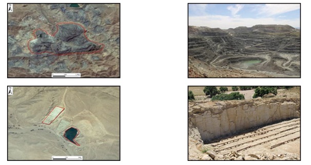
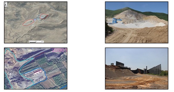
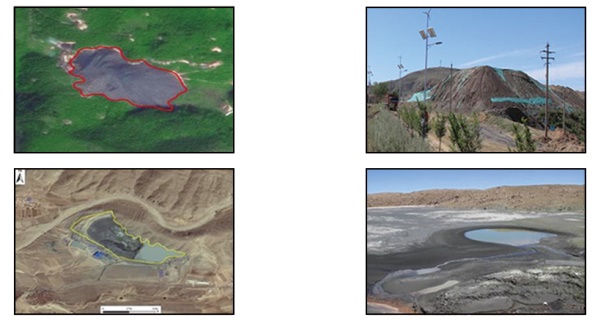
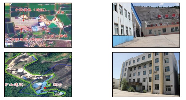
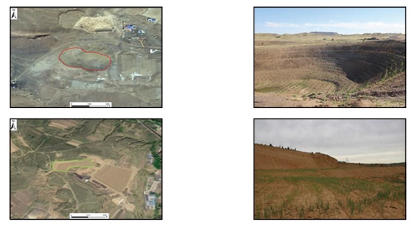
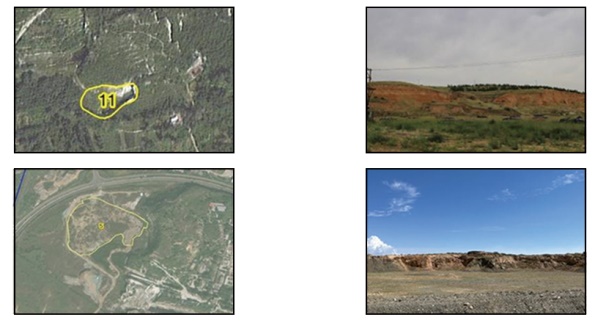
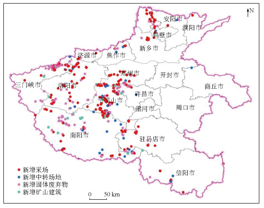
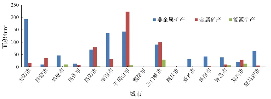
Remote sensing technology plays a significant role in mining and geological environment monitoring. Based on the ArcGIS platform, and using the preprocessed data of high-spatial-resolution satellite remote sensing images for Henan Province obtained in 2020 and 2021 as the information source, this study derived the information of the new mining-destroyed land and associated restoration and management through remote sensing interpretation marks and visual interpretation. Through statistical analysis, this study summarized the mining-destroyed land characteristics and the restoration and management status throughout Henan Province, followed by suggestions for existing problems. Overall, this study provides a reference for government departments to make decisions and for protecting geological environments in mines.

Key wordsHenan Province    mining-induced destruction    mine restoration and management    remote sensing monitoring
收稿日期: 2023-07-24      出版日期: 2025-07-01
ZTFLH:  TP79  
基金资助:中国地质调查局地质调查项目“华北地区自然资源动态监测与风险评估”(DD20230101)
通讯作者: 刘晓雪(1981-),女,硕士,高级工程师,主要从事地质矿产、遥感地质工作。Email: 46963752@qq.com
作者简介: 刘欢(1983-),女,硕士,正高级工程师,主要从事地质矿产、遥感地质工作。Email: 17769266@qq.com
引用本文:   
刘欢, 刘晓雪, 张云, 杨俊泉, 曾辉. 河南省2021年新增矿山损毁和恢复治理遥感监测状况及存在问题[J]. 自然资源遥感, 2025, 37(3): 23-31.
LIU Huan, LIU Xiaoxue, ZHANG Yun, YANG Junquan, ZENG Hui. Remote sensing monitoring status and existing problems of new mining-destroyed land and land restoration and management in Henan Province in 2021. Remote Sensing for Natural Resources, 2025, 37(3): 23-31.
链接本文:  
https://www.gtzyyg.com/CN/10.6046/zrzyyg.2023400      或      https://www.gtzyyg.com/CN/Y2025/V37/I3/23
类型 遥感影像 示例照片 识别特征
采场 金属矿采场:呈不规则形状,色调明显区别于周围自然地表,纹理明显,有道路相通,呈负地形。非金属矿采场:边界清晰,颜色较亮,受机械外力作用,纹理较粗糙杂乱,呈负地形,其上可看到颗粒状矿石和开矿活动痕迹。均为露天矿山
中转场地 指临时堆放矿石或加工矿石的场所。矿石堆一般分布于采场附近或地势较为平坦的地方,在影像上表现为一个或多个倒立椎体,边界较清楚,颜色较浅,场地内多有选矿设备或运输通道。选矿场和选矿池在影像上可见几何形状的围墙或环形选矿池
固体废弃物 指堆放矿石废渣的场所。固体废弃物地势高于周围地物,影像纹理粗糙,但立体感较强,边界清晰。尾矿库通常分布在沟谷地带,处于地势低洼部位,常灌有积水,影像上可见明显的拦坝,积水往往呈现暗灰色-浅灰色-灰绿的渐变色调,库内尾砂颗粒均匀细腻,无植被或植被稀疏
矿山建筑 指矿山企业在矿山开发、勘查时的基础设施建设场地和生活办公用地。形状规则,一般呈矩形排列。屋顶多呈红色、灰色或蓝色,边界较清楚,纹理简单
工程恢复治理 包括废石清理、采坑回填、护坡、覆土、复绿、造景等工程防治措施,场地明显经过人工平整。在遥感影像上呈青绿色或墨绿色,与周围自然的植被相比,纹理规则,人工种植痕迹明显
自然恢复治理 通常无人为参与,矿山关闭后,松散裸露面趋于稳定,植被与周围自然植被差异不大,影像上纹理杂乱
Tab.1  矿山占地类型和恢复治理遥感解译标志一览表
Fig.1  2021年度研究区新增矿山损毁土地遥感监测图
Fig.2  河南省2021年各市不同矿种新增矿山损毁土地面积
Fig.3  河南省2021年各市不同矿山类型新增矿山损毁土地面积
损毁前地类 损毁后地类 总计
采场 中转场地 固体废弃物 矿山建筑
耕地 190.09 67.61 43.36 1.77 302.83
林地 604.66 86.13 221.88 43.31 955.98
草地 148.30 19.80 34.65 1.45 204.19
工矿仓储用地 0.00 0.82 2.68 0.00 3.50
水域及水利设施用地 0.00 0.00 0.62 0.00 0.62
其他土地 42.69 5.57 3.40 0.00 51.65
总计 985.74 179.92 306.59 46.52 1 518.78
Tab.2  河南省2021年损毁前后地类新增矿山损毁土地面积统计表
Fig.4  2021年度研究区新增矿山环境恢复治理遥感监测图
Fig.5  河南省2021年各市不同矿山类型新增矿山恢复治理面积
Fig.6  河南省2021年不同治理前类型新增矿山环境恢复治理分布图
Fig.7  河南省2021年恢复治理后类型新增矿山环境恢复治理分布图
Fig.8  河南省2021年各市净增矿山恢复治理面积
[1] 翟明国, 胡波. 矿产资源国家安全、国际争夺与国家战略之思考[J]. 地球科学与环境学报, 2021, 43(1):1-11.
Zhai M G, Hu B. Thinking to state security,international competition and national strategy of mineral resources[J]. Journal of Earth Sciences and Environment, 2021, 43(1):1-11.
[2] 杨金中, 聂洪峰, 荆青青. 初论全国矿山地质环境现状与存在问题[J]. 国土资源遥感, 2017, 29(2):1-7.doi:10.6046/gtzyyg.2017.02.01.
Yang J Z, Nie H F, Jing Q Q. Preliminary analysis of mine geo-environment status and existing problems in China[J]. Remote Sen-sing for Land and Resources, 2017, 29(2):1-7.doi:10.6046/gtzyyg.2017.02.01.
[3] 杨金中, 许文佳, 姚维岭, 等. 全国采矿损毁土地分布与治理状况及存在问题[J]. 地学前缘, 2021, 28(4):83-89.
doi: 10.13745/j.esf.sf.2020.10.8
Yang J Z, Xu W J, Yao W L, et al. Land destroyed by mining in China:Damagedistribution,rehabilitation status and existing problems[J]. Earth Science Frontiers, 2021, 28(4):83-89.
[4] 杨金中, 秦绪文, 张志. 矿山遥感监测理论方法与实践[M]. 北京: 测绘出版社, 2011.
Yang J Z, Qin X W, Zhang Z. Theory and practice on remote sen-sing monitoring of mine[M]. Beijing: Sino Maps Press, 2011.
[5] 杨金中, 秦绪文, 聂洪峰. 中国矿山遥感监测[M]. 北京: 测绘出版社, 2014.
Yang J Z, Qin X W, Nie H F. Remote sensing monitoring of mine in China[M]. Beijing: Sino Maps Press, 2014.
[6] 杨金中, 秦绪文, 聂洪峰, 等. 全国重点矿区矿山遥感监测综合研究[J]. 中国地质调查, 2015, 2(4):24-30.
Yang J Z, Qin X W, Nie H F, et al. Comprehensive research on remote sensing monitoring of the national concentration zones of the important mine[J]. Geological Survey of China, 2015, 2(4):24-30.
[7] 秦绪文, 杨金中, 康高峰. 矿山遥感监测技术方法研究[M]. 北京: 测绘出版社, 2011.
Qin X W, Yang J Z, Kang G F. Technology and method research on remote sensing monitoring of mine[M]. Beijing: Sino Maps Press, 2011.
[8] 姚维岭, 荆青青, 周英杰, 等. 基于遥感动态监测的山东省矿山地质环境恢复治理典型模式分析[J]. 矿产勘查, 2015, 6(5):627-634.
Yao W L, Jing Q Q, Zhou Y J, et al. Analysis on typical pattern of mine geological environment restoration and governance based on remote sensing dynamic monitoring in Shandong[J]. Mineral Exploration, 2015, 6(5):627-634.
[9] 周英杰, 李思佳, 魏红艳, 等. “高分一号02、03、04星”卫星数据在矿山开发环境遥感监测中的初步应用评价[J]. 测绘与空间地理信息, 2020, 43(3):73-75,78.
Zhou Y J, Li S J, Wei H Y, et al. Preliminary application evaluation of “GF1 02,03,04 satellite data” in remote sensing monitoring of mine development environment[J]. Geomatics and Spatial Information Technology, 2020, 43(3):73-75,78.
[10] 刘欢, 张云, 黄旭红, 等. 遥感技术在内蒙古自治区中西部重点矿区开采监测中的应用[J]. 华北地质, 2021, 44(4):55-60.
Liu H, Zhang Y, Huang X H, et al. Application of remote sensing technology in mining monitoring in midwest major mining area of Inner Mongolia[J]. North China Geology, 2021, 44(4):55-60.
[11] 王立娟, 靳晓, 贾虎军, 等. 基于国产高分卫星数据的矿山环境变化检测[J]. 国土资源遥感, 2018, 30(3):151-158.doi:10.6046/gtzyyg.2018.03.21.
Wang L J, Jin X, Jia H J, et al. Change detection for mine environment based on domestic high resolution satellite images[J]. Remote Sensing for Land and Resources, 2018, 30(3):151-158.doi:10.6046/gtzyyg.2018.03.21.
[12] 王晓红, 聂洪峰, 杨清华, 等. 高分辨率卫星数据在矿山开发状况及环境监测中的应用效果比较[J]. 国土资源遥感, 2004, 16(1):15-18,80.doi:10.6046/gtzyyg.2004.01.04.
Wang X H, Nie H F, Yang Q H, et al. The different monitoring effects of QuickBird and Spot-5 data in mine exploitation[J]. Remote Sensing for Land and Resources, 2004, 16(1):15-18,80.doi:10.6046/gtzyyg.2004.01.04.
[13] 修晓龙. 山西省矿山开发新增损毁土地年度监测与分析[J]. 中国矿业, 2022, 31(2):59-64.
Xiu X L. Annual monitoring and analysis of newly damaged land in mine development in Shanxi Province[J]. China Mining Magazine, 2022, 31(2):59-64.
[14] 刘立, 李长安, 高俊华, 等. 多源卫星遥感的湖南矿山违法开采时空变化[J]. 遥感学报, 2022, 26(3):528-540.
Liu L, Li C A, Gao J H, et al. Spatiotemporal changes of illegal mining in Hunan mines based on multi-source satellite remote sensing[J]. National Remote Sensing Bulletin, 2022, 26(3):528-540.
[15] 殷亚秋, 蒋存浩, 鞠星, 等. 海南岛2018年矿山地质环境遥感评价和生态修复对策[J]. 自然资源遥感, 2022, 34(2):194-202.doi:10.6046/zrzyyg.2021136.
Yin Y Q, Jiang C H, Ju X, et al. Remote sensing evaluation of mine geological environment of Hainan Island in 2018 and ecological restoration countermeasures[J]. Remote Sensing for Natural Resources, 2022, 34(2):194-202.doi:10.6046/zrzyyg.2021136.
[16] 许文佳, 白中科, 杨金中, 等. 黄河源区矿山开发生态受损识别诊断[J]. 中国土地科学, 2022, 36(4):118-126.
Xu W J, Bai Z K, Yang J Z, et al. Identification and diagnosis of ecosystem damaged by mining development in the source area of the Yellow River[J]. China Land Science, 2022, 36(4):118-126.
[17] 汪洁, 殷亚秋, 于航, 等. 基于RS和GIS的浙江省矿山地质环境遥感监测[J]. 国土资源遥感, 2020, 32(1):232-236.doi:10.6046/gtzyyg.2020.01.31.
Wang J, Yin Y Q, Yu H, et al. Remote sensing monitoring of mine geological environment in Zhejiang Province based on RS and GIS[J]. Remote Sensing for Land and Resources, 2020, 32(1):232-236.doi:10.6046/gtzyyg.2020.01.31.
[18] 王建华, 李阳, 梁树能, 等. 基于高光谱卫星数据的土地沙化识别及提取研究[J]. 华北地质, 2022, 45(4):60-67.
doi: 10.19948/j.12-1471/P.2022.04.08
Wang J H, Li Y, Liang S N, et al. The study of land desertification recognition and extraction based on hyperspectral satellite data[J]. North China Geology, 2022, 45(4):60-67.
[19] 河南省自然资源厅. 2019年河南省自然资源公报[EB/OL]. [2020-11-06]. https://dnr.henan.gov.cn/2020/11-06/1886316.html.
Department of Natural Resouces of Henan Province. Communique of Natural Resouces of Henan Province in 2019[EB/OL]. [2020-11-06]. https://dnr.henan.gov.cn/2020/11-06/1886316.html.
[20] 侯冰, 刘向敏, 余振国. 对我国构建矿山生态修复制度的思考[J]. 中国国土资源经济, 2022, 35(9):76-81.
Hou B, Liu X M, Yu Z G. The consideration of constructing mine ecological restoration system in China[J]. Natural Resource Economics of China, 2022, 35(9):76-81.
[21] 许晓明, 胡国峰, 邵雁, 等. 我国矿山生态修复发展状况及趋势分析[J]. 矿产勘查, 2022, 13(s1):309-314.
Xu X M, Hu G F, Shao Y, et al. Analysis on the development status and trend of mine ecological restoration in China[J]. Mineral Exploration, 2022, 13(s1):309-314.
[1] 赵丽君, 刘欢, 张云, 杨俊泉, 王威, 陈东磊. 山东省矿山损毁土地和治理状况2021年度监测与分析[J]. 自然资源遥感, 2025, 37(3): 17-22.
[2] 李婷, 叶丽娟, 杨俊泉, 张静, 张云, 刘欢. 内蒙古中西部矿山地质环境遥感调查[J]. 自然资源遥感, 2025, 37(3): 45-53.
[3] 石海岗, 梁春利, 薛庆, 张恩, 章新益, 张建永, 张春雷, 程旭. 基于卫星遥感的秦山核电周边海域温度分布研究[J]. 自然资源遥感, 2025, 37(1): 152-160.
[4] 康辉, 窦文章, 韩灵怡, 丁梓越, 吴亮廷, 侯璐. 基于DeepLabv3+模型的地表水体快速遥感监测[J]. 自然资源遥感, 2024, 36(4): 117-123.
[5] 叶丽娟, 段霄龙, 李婷, 张静, 张云, 陈东磊. 河北省采矿损毁土地分布及治理状况分析[J]. 自然资源遥感, 2024, 36(4): 75-81.
[6] 孙禧勇, 刘稼丰, 范景辉, 张文凯, 石利娟, 邱玉宝, 朱发容. 积雪遥感监测产品研究与应用进展[J]. 自然资源遥感, 2024, 36(3): 13-27.
[7] 和海霞, 李博. 青海大通“8·18”山洪灾害特征及风险分析[J]. 自然资源遥感, 2024, 36(2): 135-141.
[8] 邢宇, 王静雅, 杨金中, 陈栋, 杜晓敏, 郭靖凯, 宋丽聪. 全国废弃露天矿山采矿用地分布状况与存在问题[J]. 自然资源遥感, 2024, 36(2): 21-26.
[9] 马晓雪, 焦润成, 曹颖, 南赟, 王晟宇, 郭学飞, 赵丹凝, 闫驰, 倪璇. 重大工程建设中地质灾害综合遥感监测技术方法应用——以北京2022冬奥会延庆赛区为例[J]. 自然资源遥感, 2024, 36(2): 248-256.
[10] 周小迦. 丘陵地带耕地撂荒遥感监测应用研究[J]. 自然资源遥感, 2024, 36(1): 235-241.
[11] 职露, 胡涛, 邹滨, 李浩生, 赵永强. 河南省植被NPP时空分异及其驱动因子[J]. 自然资源遥感, 2023, 35(4): 169-177.
[12] 郭艺, 甘甫平, 闫柏琨, 白娟, 邢乃琛, 刘琪. 1948—2021年河南省土壤含水量时空分布特征及其影响因素研究[J]. 自然资源遥感, 2023, 35(3): 241-252.
[13] 于航, 安娜, 汪洁, 邢宇, 许文佳, 步凡, 王晓红, 杨金中. 黔西南采煤塌陷区高分遥感动态监测——以六盘水市煤矿采空塌陷区为例[J]. 自然资源遥感, 2023, 35(3): 310-318.
[14] 李星佑, 张飞, 王筝. 土壤盐渍化遥感监测模型构建方法现状与发展趋势[J]. 自然资源遥感, 2022, 34(4): 11-21.
[15] 王娟, 王志红, 张建国, 初娜, 李斯, 尹展. 河南省国家级自然保护区人类活动遥感监测及其影响强度评价[J]. 自然资源遥感, 2022, 34(4): 235-242.
Viewed
Full text


Abstract

Cited

  Shared   
  Discussed   
京ICP备05055290号-2
版权所有 © 2015 《自然资源遥感》编辑部
地址:北京学院路31号中国国土资源航空物探遥感中心 邮编:100083
电话:010-62060291/62060292 E-mail:zrzyyg@163.com
本系统由北京玛格泰克科技发展有限公司设计开发