SBAS-InSAR-based long time-series deformation monitoring and landslide hazard identification in the Baihetan reservoir area
YU Bing1,2,3(), ZHANG Chunyu1, WANG Jinri1, LIU Guoxiang4, DAI Keren5, MA Deying1
1. School of Civil Engineering and Geomatics, Southwest Petroleum University, Chengdu 610500, China 2. Key Laboratory of Remote Sensing and Mapping Information Technology for Oil and Gas Fields in the Petroleum and Chemical Industry, Chengdu 610500, China 3. Institute of Petroleum and Natural Gas Spatial Information Engineering, Southwest Petroleum University, Chengdu 610500, China 4. Faculty of Geosciences and Environmental Engineering, Southwest Jiaotong University, Chengdu 611756, China 5. School of Earth Science, Chengdu University of Technology, Chengdu 610059, China
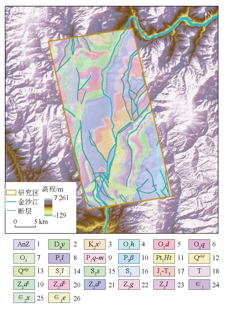
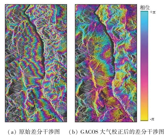
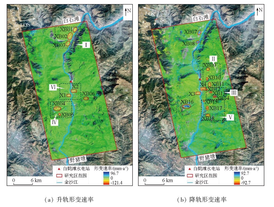
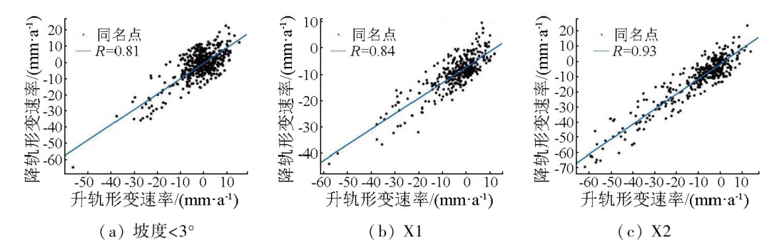
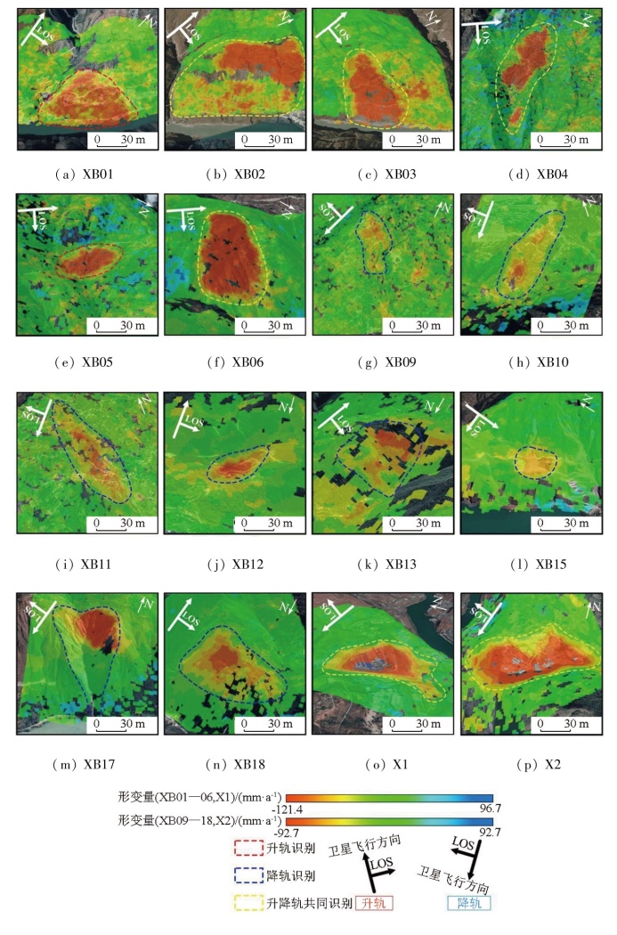
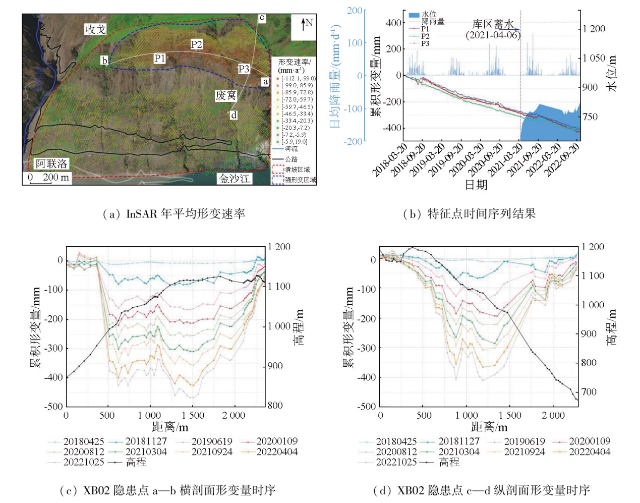
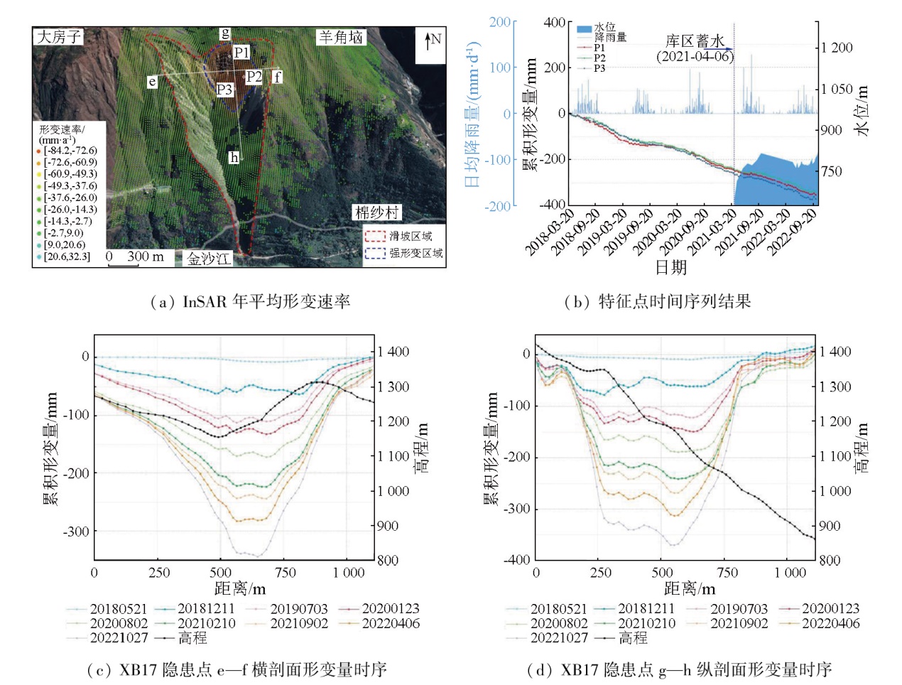
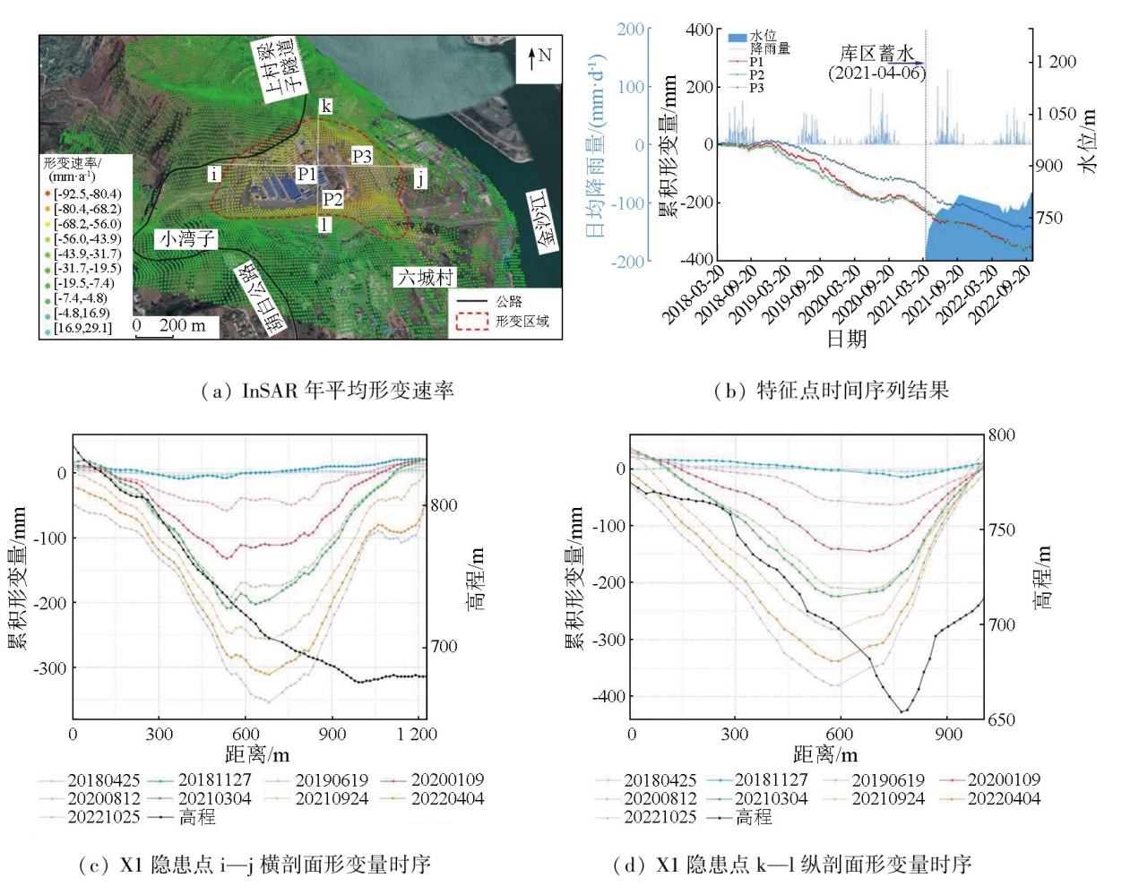
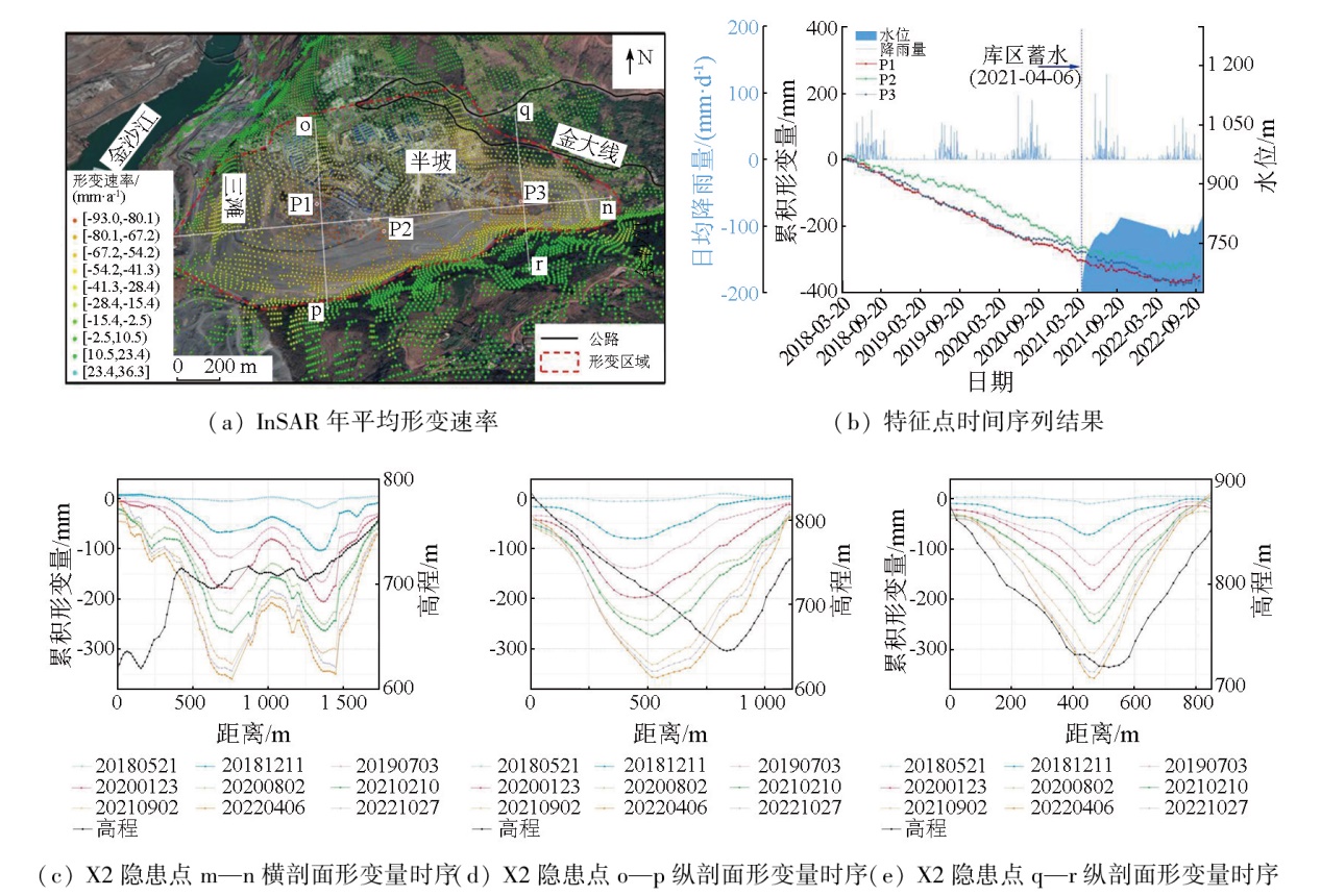
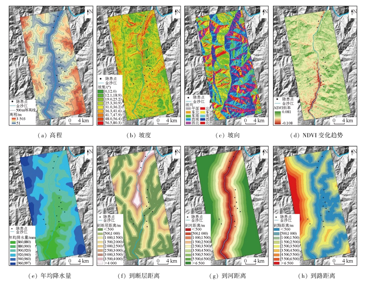
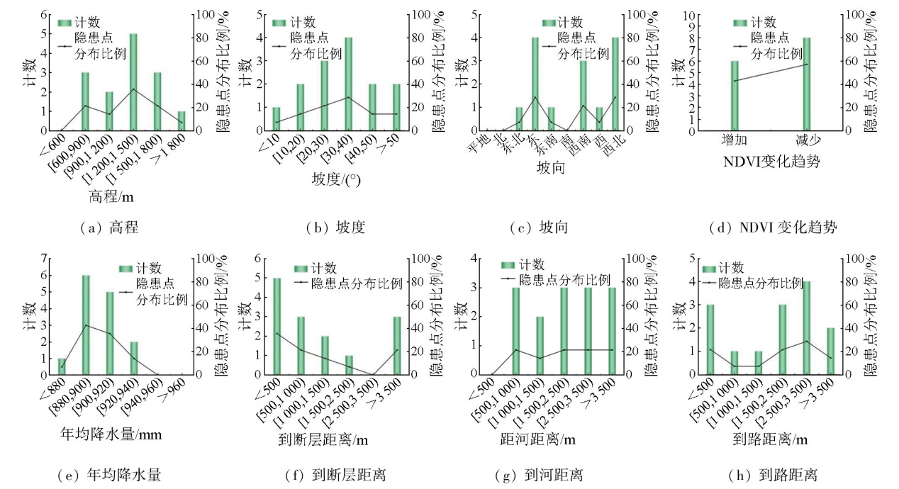
The reservoir area of the Baihetan hydropower station (also referred to as the Baihetan reservoir area) suffers from frequent geologic hazards. However, there is a lack of monitoring studies on the central area and lower reaches of the hydropower station. Based on the ascending and descending synthetic aperture Radar (SAR) images from the Sentinel-1A satellite, this study performed deformation monitoring and landslide hazard identification in the Baishitan-Yezhutang section of the Baihetan reservoir area using the small baseline subset-interferometric synthetic aperture Radar (SBAS-InSAR) method supported by the generic atmospheric correction online service for InSAR (GACOS). Moreover, this study conducted cross-validation of deformation data from ascending and descending SAR images for low-slope zones. It investigated the spatial distribution of landslide hazards and the movement patterns of typical hazard sites in the study area. Finally, it examined the impacts of factors influencing geologic hazards on the distribution of these hazard sites. The results indicate that the deformation data from ascending and descending SAR images for low-slope zones can be used for cross-validation. Based on the deformation detection results from time-series InSAR and the optical images from Google Earth, 16 landslide hazards were identified, including 14 slow-moving landslides and two significant deformation hazards induced by human engineering activities. Integrating the data of ascending and descending SAR images validated the reliability of deformation results and also enhanced the effectiveness of landslide hazard identification. The analysis of the movement patterns at typical hazard sites indicates a correlation between deformation acceleration and seasonal rainfall. The statistical analysis of factors influencing geologic hazards in the study area reveals that the formation of hazard sites is driven by multiple factors, with varying dominant factors and degrees of influence across different hazards.
于冰, 张椿雨, 王金日, 刘国祥, 戴可人, 马德英. 基于SBAS-InSAR的白鹤滩库区长时序形变监测与滑坡隐患识别[J]. 自然资源遥感, 2025, 37(6): 156-168.
YU Bing, ZHANG Chunyu, WANG Jinri, LIU Guoxiang, DAI Keren, MA Deying. SBAS-InSAR-based long time-series deformation monitoring and landslide hazard identification in the Baihetan reservoir area. Remote Sensing for Natural Resources, 2025, 37(6): 156-168.
Liu X J. Research on key technologies for early identification,monitoring and forecasting of wide-area landslides with spaceborne Radar remote sensing[D]. Xi’an: Chang’an University, 2022.
Dai K R, Wu M T, Zhuo G C, et al. Review on InSAR early identification and monitoring of reservoir landslides for large hydropower engineering projects in southwest mountainous area of China[J]. Journal of Earth Sciences and Environment, 2023, 45(3):559-577.
Kang Y, Zhao C Y, Zhang Q, et al. Research on the InSAR technique of landslide detection:A case study of Wudongde hydropower station section,Jinshajiang[J]. Journal of Geodesy and Geodynamics, 2018, 38(10):1053-1057.
Xu Q. Understanding and consideration of related issues in early identification of potential geohazards[J]. Geomatics and Information Science of Wuhan University, 2020, 45(11):1651-1659.
Xu Q, Pu C H, Zhao K Y, et al. Time series InSAR monitoring and analysis of spatiotemporal evolution characteristics of land subsidence in Yan’an New District[J]. Geomatics and Information Science of Wuhan University, 2021, 46(7):957-969.
[6]
Ferretti A, Prati C, Rocca F. Nonlinear subsidence rate estimation using permanent scatterers in differential SAR interferometry[J]. IEEE Transactions on Geoscience and Remote Sensing, 2000, 38(5):2202-2212.
doi: 10.1109/36.868878
[7]
Berardino P, Fornaro G, Lanari R, et al. A new algorithm for surface deformation monitoring based on small baseline differential SAR interferograms[J]. IEEE Transactions on Geoscience and Remote Sensing, 2002, 40(11):2375-2383.
doi: 10.1109/TGRS.2002.803792
[8]
Ferretti A, Fumagalli A, Novali F, et al. A new algorithm for processing interferometric data-stacks:SqueeSAR[J]. IEEE Transactions on Geoscience and Remote Sensing, 2011, 49(9):3460-3470.
doi: 10.1109/TGRS.2011.2124465
Dai K R, Shen Y, Wu M T, et al. Identification of potential landslides in Baihetan Dam area before the impoundment by combining InSAR and UAV survey[J]. Acta Geodaetica et Cartographica Si-nica, 2022, 51(10):2069-2082.
Wu M T, Cui Z H, Yi X Y, et al. Identification of geohazards in Xiangbiling-Yezhutang section of Baihetan Reservoir area using multi-source remote sensing data[J]. Journal of Changjiang River Scientific Research Institute, 2023, 40(4):155-163.
Dun J W, Feng W K, Yi X Y, et al. Early insar identification of active landslide before impoundment in Baihetan Reservoir area:A case study of Hulukou Town Xiangbiling section[J]. Journal of Engineering Geology, 2023, 31(2):479-492.
[12]
Dai K R, Chen C, Shi X L, et al. Dynamic landslides susceptibility evaluation in Baihetan Dam area during extensive impoundment by integrating geological model and InSAR observations[J]. International Journal of Applied Earth Observation and Geoinformation, 2023,116:103157.
[13]
Liu Y, Yao X, Gu Z K, et al. Research on automatic recognition of active landslides using InSAR deformation under digital morphology:A case study of the Baihetan reservoir,China[J]. Remote Sensing of Environment, 2024,304:114029.
[14]
Zhu Y R, Qiu H J, Liu Z J, et al. Rainfall and water level fluctuations dominated the landslide deformation at Baihetan Reservoir,China[J]. Journal of Hydrology, 2024,642:131871.
Zhu S N, Yin Y P, Wang M, et al. Instability mechanism and disaster mitigation measures of long-distance landslide at high location in Jinsha River junction zone:Case study of Sela landslide in Jinsha River,Tibet[J]. Chinese Journal of Geotechnical Engineering, 2021, 43(4):688-697.
[16]
Yu C, Penna N T, Li Z H. Generation of real-time mode high-resolution water vapor fields from GPS observations[J]. Journal of Geophysical Research:Atmospheres, 2017, 122(3):2008-2025.
doi: 10.1002/jgrd.v122.3
Li D. Deformation monitoring and regional susceptibility assessment of Shaziba landslide in Enshi based on time series InSAR Technology[D]. Wuhan: Central China Normal University, 2021.
[18]
Hooper A, Bekaert D, Spaans K, et al. Recent advances in SAR interferometry time series analysis for measuring crustal deformation[J]. Tectonophysics, 2012,514:1-13.
[19]
Xu B, Li Z W, Wang Q J, et al. A refined strategy for removing composite errors of SAR interferogram[J]. IEEE Geoscience and Remote Sensing Letters, 2014, 11(1):143-147.
doi: 10.1109/LGRS.2013.2250903
[20]
Wang Q J, Yu W Y, Xu B, et al. Assessing the use of GACOS pro-ducts for SBAS-InSAR deformation monitoring:A case in southern California[J]. Sensors, 2019, 19(18):3894.
doi: 10.3390/s19183894
Liu Y F. Study on monitoring method of surface subsidence in filling mining area based on DS-InSAR[D]. Xuzhou: China University of Mining and Technology, 2021.
Li S L, Xu Q, Tang M G, et al. Study on spatial distribution and key influencing factors of landslides in Three Gorges Reservoir area[J]. Earth Science, 2020, 45(1):341-354.
Fang M, Zhang J L, Xu Z. Landslide susceptibility zoning study in Lanzhou City based on GIS and logistic regression model[J]. Remote Sensing Technology and Application, 2011, 26(6):845-854.
[24]
Collins B D, Stock G M. Rockfall triggering by cyclic thermal stressing of exfoliation fractures[J]. Nature Geoscience, 2016, 9(5):395-400.
doi: 10.1038/NGEO2686
Li Y X, Zhang Y, Su X J, et al. Early identification and characteristics of potential landslides in the Bailong River Basin using InSAR technique[J]. National Remote Sensing Bulletin, 2021, 25(2):677-690.
doi: 10.11834/jrs.20210094
[26]
胡俊. 基于现代测量平差的InSAR三维形变估计理论与方法[D]. 长沙: 中南大学, 2013.
Hu J. Theory and method of estimating three-dimensional displacement with InSAR based on the modern surveying adjustment[D]. Changsha: Central South University, 2013.
[27]
曹中山. 基于易发性和临界降雨阈值的滑坡危险性预警建模研究[D]. 南昌: 南昌大学, 2020.
Cao Z S. Study on landslide risk warning modeling based on sensitivity and critical rainfall threshold[D]. Nanchang: Nanchang University, 2020.
[28]
Huang F M, Chen J W, Liu W P, et al. Regional rainfall-induced landslide hazard warning based on landslide susceptibility mapping and a critical rainfall threshold[J]. Geomorphology, 2022,408:108236.
Yao X, Deng J H, Liu X H, et al. Primary recognition of active landslides and development rule analysis for pan three-river-parallel territory of Tibet Plateau[J]. Advanced Engineering Sciences, 2020, 52(5):16-37.
Cheng H Q, Chen Q, Liu G X, et al. Post-earthquake landslides distribution along Longmenshan major fault during rainy season with short-baseline InSAR[J]. Acta Geodaetica et Cartographica Sinica, 2014, 43(9):931-938.
 2025, Vol. 37
  ), 张椿雨1, 王金日1, 刘国祥4, 戴可人5, 马德英1