Change detection of satellite time series images based on spatial-temporal-spectral features
QIN Le1(), HE Peng2, MA Yuzhong3, LIU Jianqiang4, YANG Bin1()
1. College of Electrical and Information Engineering, Hunan University, Changsha 410082, China 2. School of Mechanical Engineering, University of South China, Hengyang 421000, China 3. Shandong Provincial Institute of Land Surveying and Mapping, Jinan 250014, China 4. Key Laboratory of Space Ocean Remote Sensing and Application, Ministry of Natural Resources, Beijing 100081, China
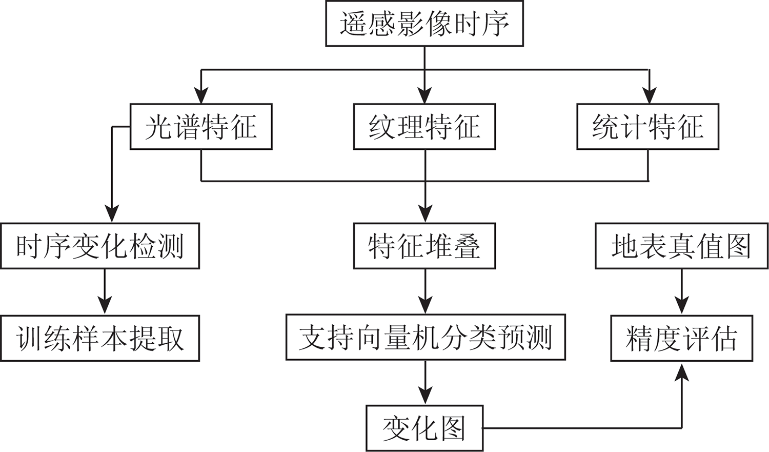
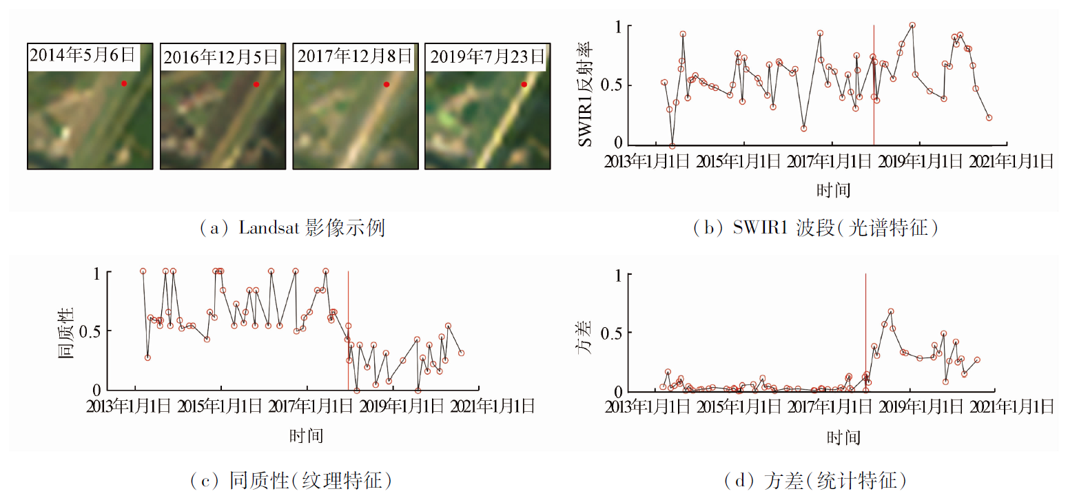
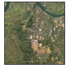
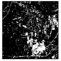
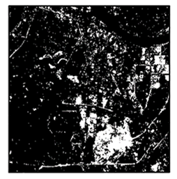
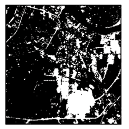
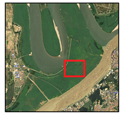
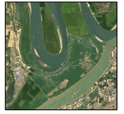
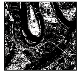
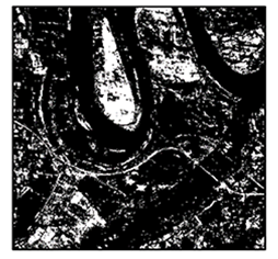
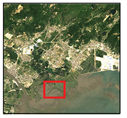
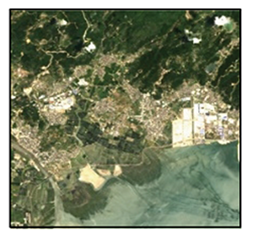
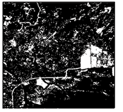
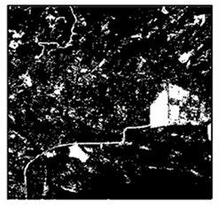
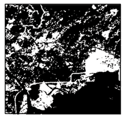
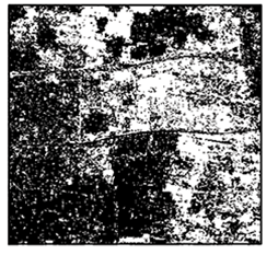
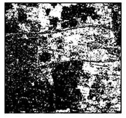
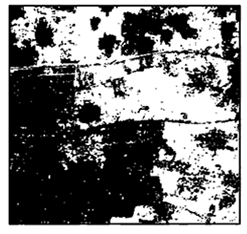
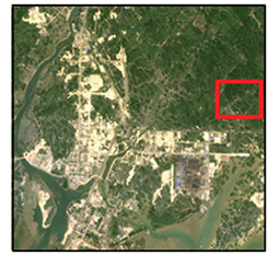
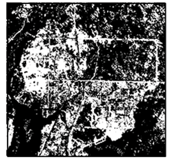
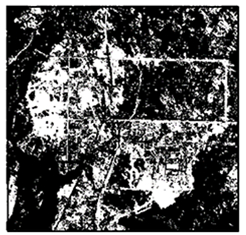
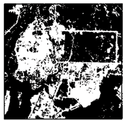
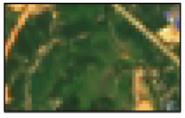
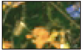
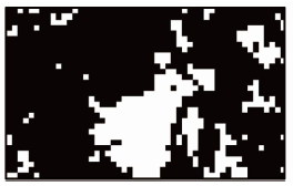
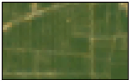
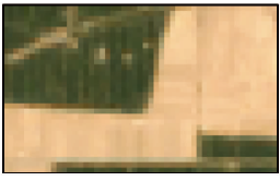
相较于常见的双时相遥感影像,时间序列遥感影像包含更丰富的地表信息,能够缓解“异物同谱”、“同物异谱”的影响,因而在变化检测中具有重要作用。但是目前时间序列遥感影像变化检测方法大多基于像素展开,忽略了像素和周围环境的空间关系,导致变化检测结果“噪声”现象明显。基于此,提出了一种基于时空谱特征的时间序列遥感变化检测算法(change detection based on spatial-temporal-spectral features, CDSTS)。首先,利用灰度共生矩阵和局部统计计算方法,从Landsat时间序列遥感影像中提取每个像素点的时间、空间(纹理和统计)和光谱特征; 其次,通过每个像素在不同波段上的时间序列表现规律,自动筛选出时序特征异常点,并与连续变化检测和分类法(continuous change detection and classification, CCDC)检测结果融合获取高精度变化/未变化训练样本点; 最后,利用上述样本点及其对应的时空谱特征训练支持向量机分类器,并基于该分类器对全图进行分类。结果表明,CDSTS算法在变化区域检测精准度方面明显优于常用的时间序列变化检测算法CCDC和土地扰动连续监测方法(continuous monitoring of land disturbance,COLD),总体精度提升了4.8~11.7百分点。
Compared with common dual-temporal satellite images, satellite time series images contain richer surface information and can alleviate the impact of foreign objects with the same spectrum and the same object with different spectra. Therefore, they play an important role in change detection. However, the change detection methods for satellite time series images are mostly based on pixels and ignore the spatial relationship between pixels and their surroundings. This causes noise in the change detection result. Accordingly, this study proposed a method of change detection based on spatial-temporal-spectral features(CDSTS) for satellite time series images. First, the temporal, spatial (textural and statistical), and spectral features of each pixel were extracted from Landsat time series images using a gray-level co-occurrence matrix and local statistical calculation methods. Then, anomalies of time series features were automatically screened according to the time series performance regularity of each pixel in different bands. These anomalies were then fused with the detection results of the continuous change detection and classification method (CCDC) to obtain high-precision changed/unchanged training sample points. Finally, the SVM classifier was trained using the training sample points and their corresponding spatial-temporal-spectral features for full graph classification. The results show that the CDSTS algorithm significantly outperforms the commonly used time series change detection algorithms CCDC and COLD (continuous monitoring of land disturbance) in terms of change detection precision, with the overall precision improved by 4.8 to 11.7 percentage points.
秦乐, 何鹏, 马玉忠, 刘建强, 杨彬. 基于时空谱特征的遥感影像时间序列变化检测[J]. 自然资源遥感, 2022, 34(4): 105-112.
QIN Le, HE Peng, MA Yuzhong, LIU Jianqiang, YANG Bin. Change detection of satellite time series images based on spatial-temporal-spectral features. Remote Sensing for Natural Resources, 2022, 34(4): 105-112.
Singh A. Review article digital change detection techniques using remotely-sensed data[J]. International Journal of Remote Sensing, 1989, 10(6):989-1003.
doi: 10.1080/01431168908903939
[2]
Silveira E M O, Bueno I T, Acerbi-Junior F W, et al. Using spatial features to reduce the impact of seasonality for detecting tropical forest changes from Landsat time series[J]. Remote Sensing, 2018, 10(6):808.
doi: 10.3390/rs10060808
[3]
Gómez C, White J C, Wulder M A. Optical remotely sensed time series data for land cover classification:A review[J]. ISPRS Journal of Photogrammetry and Remote Sensing, 2016, 116:55-72.
doi: 10.1016/j.isprsjprs.2016.03.008
[4]
Hussain M, Chen D, Cheng A, et al. Change detection from remotely sensed images:From pixel-based to object-based approaches[J]. ISPRS Journal of Photogrammetry and Remote Sensing, 2013, 80:91-106.
doi: 10.1016/j.isprsjprs.2013.03.006
[5]
Roy D P, Wulder M A, Loveland T R, et al. Landsat8:Science and product vision for terrestrial global change research[J]. Remote Sensing of Environment, 2014, 145:154-172.
doi: 10.1016/j.rse.2014.02.001
[6]
Zhu Z, Woodcock C E, Holden C, et al. Generating synthetic Landsat images based on all available Landsat data:Predicting Landsat surface reflectance at any given time[J]. Remote Sensing of Environment, 2015, 162:67-83.
doi: 10.1016/j.rse.2015.02.009
Zhang L P, Wu C. The status quo and prospects of multi-temporal remote sensing image change detection[J]. Journal of Surveying and Mapping, 2017, 46(10):1447-1459.
Wang Z Y, Li H, Liu Z Z, et al. Satellite image change monitoring based on deep learning algorithm[J]. Computer System Applications, 2020, 29(1):40-48.
[9]
Celik T. Unsupervised change detection in satellite images using principal component analysis and K-means clustering[J]. IEEE Geoscience and Remote Sensing Letters, 2009, 6(4):772-776.
doi: 10.1109/LGRS.2009.2025059
[10]
Tewkesbury A P, Comber A J, Tate N J, et al. A critical synthesis of remotely sensed optical image change detection techniques[J]. Remote Sensing of Environment, 2015, 160:1-14.
doi: 10.1016/j.rse.2015.01.006
[11]
Gong M G, Zhan T, Zhang P Z, et al. Superpixel-based difference representation learning for change detection in multispectral remote sensing images[J]. IEEE Transactions on Geoscience and Remote sensing, 2017, 55(5):2658-2673.
doi: 10.1109/TGRS.2017.2650198
[12]
Zhang P Z, Gong M G, Su L Z, et al. Change detection based on deep feature representation and mapping transformation for multi-spatial-resolution remote sensing images[J]. ISPRS Journal of Photogrammetry and Remote Sensing, 2016, 116:24-41.
doi: 10.1016/j.isprsjprs.2016.02.013
[13]
Woodcock C E, Loveland T R, Herold M, et al. Transitioning from change detection to monitoring with remote sensing:A paradigm shift[J]. Remote Sensing of Environment, 2020, 238:111558.
doi: 10.1016/j.rse.2019.111558
[14]
Hamunyela E, Brandt P, Shirima D, et al. Space-time detection of deforestation,forest degradation and regeneration in montane forests of eastern Tanzania[J]. International Journal of Applied Earth Observation and Geoinformation, 2020, 88:102063.
doi: 10.1016/j.jag.2020.102063
[15]
Liu C, Zhang Q, Luo H, et al. An efficient approach to capture continuous impervious surface dynamics using spatial-temporal rules and dense Landsat time series stacks[J]. Remote Sensing of Environment, 2019, 229:114-132.
doi: 10.1016/j.rse.2019.04.025
[16]
Wang Z H, Yao W Y, Tang Q H, et al. Continuous change detection of forest/grassland and cropland in the Loess Plateau of China using all available Landsat data[J]. Remote Sensing, 2018, 10(11):1775.
doi: 10.3390/rs10111775
[17]
Xiao P F, Zhang X L, Wang D G, et al. Change detection of built-up land:A framework of combining pixel-based detection and object-based recognition[J]. ISPRS Journal of Photogrammetry and Remote Sensing, 2016, 119:402-414.
doi: 10.1016/j.isprsjprs.2016.07.003
Du P J, Liu S C. Remote sensing image change detection based on multi-feature fusion[J]. Journal of Remote Sensing, 2012, 16(4):663-677.
[19]
Zhu Z. Change detection using landsat time series:A review offrequencies,preprocessing,algorithms,and applications[J]. ISPRS Journal of Photogrammetry and Remote Sensing, 2017, 130:370-384.
doi: 10.1016/j.isprsjprs.2017.06.013
[20]
Kennedy R E, Yang Z, Cohen W B. Detecting trends in forest disturbance and recovery using yearly Landsat time series:1.LandTrendr-Temporal segmentation algorithms[J]. Remote Sensing of Environment, 2010, 114(12):2897-2910.
doi: 10.1016/j.rse.2010.07.008
[21]
Huang C, Goward S N, Masek J G, et al. An automated approach for reconstructing recent forest disturbance history using dense Landsat time series stacks[J]. Remote Sensing of Environment, 2010, 114(1):183-198.
doi: 10.1016/j.rse.2009.08.017
[22]
Verbesselt J, Zeileis A, Herold M. Near real-time disturbance detection using satellite image time series[J]. Remote Sensing of Environment, 2012, 123:98-108.
doi: 10.1016/j.rse.2012.02.022
[23]
Zhu Z, Woodcock C E. Continuous change detection and classification of land cover using all available Landsat data[J]. Remote Sensing of Environment, 2013, 144(1):152-171.
doi: 10.1016/j.rse.2014.01.011
[24]
Zhu Z, Zhang J, Yang Z, et al. Continuous monitoring of land disturbance based on Landsat time series[J]. Remote Sensing of Environment, 2020, 238:111116.
doi: 10.1016/j.rse.2019.03.009
[25]
Zhang H, Gong M G, Zhang P Z, et al. Feature-level change detection using deep representation and feature change analysis for multispectral imagery[J]. IEEE Geoscience and Remote Sensing Letters, 2016, 13(11):1666-1670.
doi: 10.1109/LGRS.2016.2601930
[26]
Chen G, Hay G J, Carvalho L M T, et al. Object-based change detection[J]. International Journal of Remote Sensing, 2012, 33(14):4434-4457.
doi: 10.1080/01431161.2011.648285
 2022, Vol. 34
  ), 何鹏2, 马玉忠3, 刘建强4, 杨彬1(