Identification of mariculture areas in Guangdong Province and remote sensing monitoring of their spatial and temporal changes based on the U-Net convolutional neural network
SU Wei1(), LIN Yangyang1, YUE Wen1(), CHEN Yingbiao2
1. Land Investigation and Planning Institute of Guangdong Province, Guangzhou 511453, China 2. School of Geography and Remote Sensing, Guangzhou University, Guangzhou 510006, China
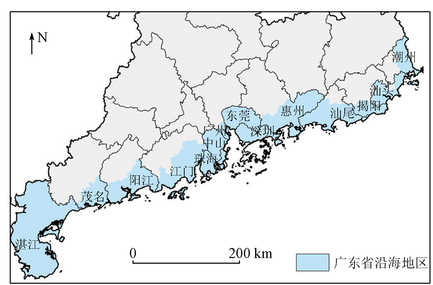
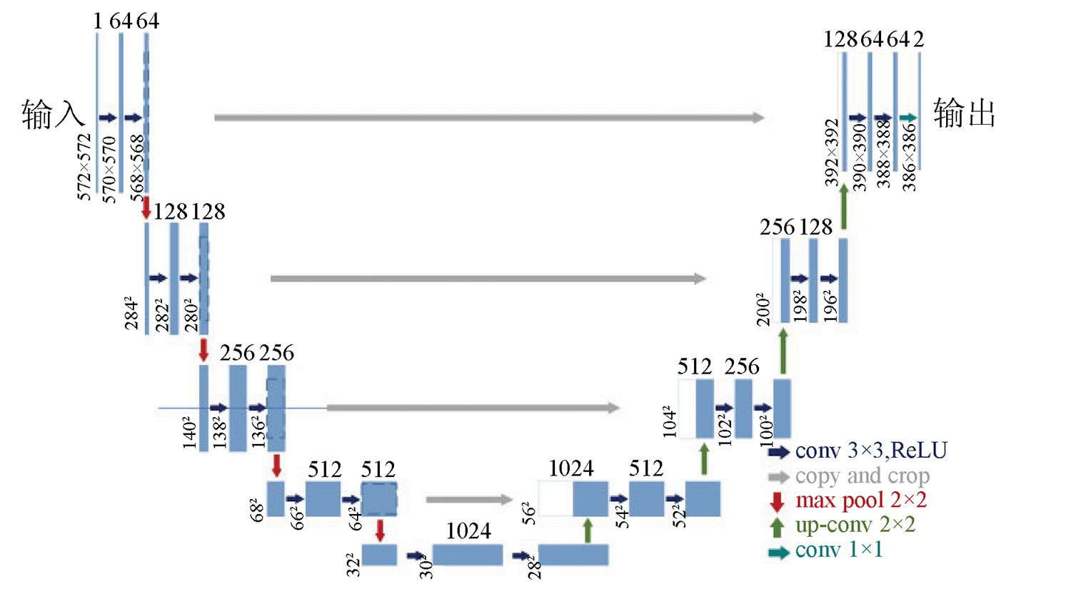
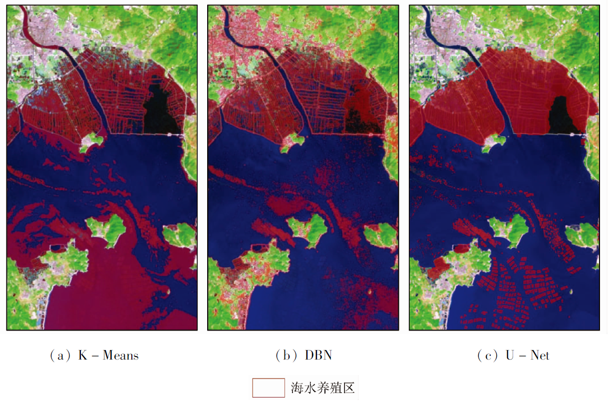
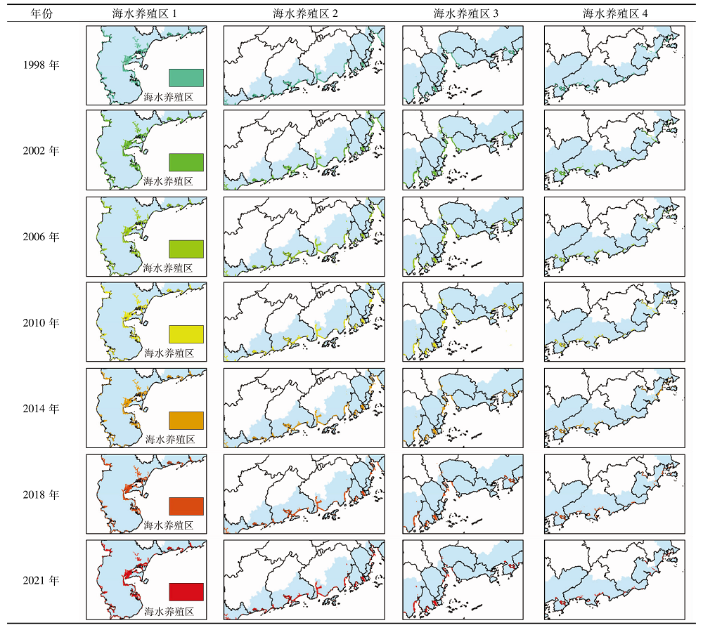
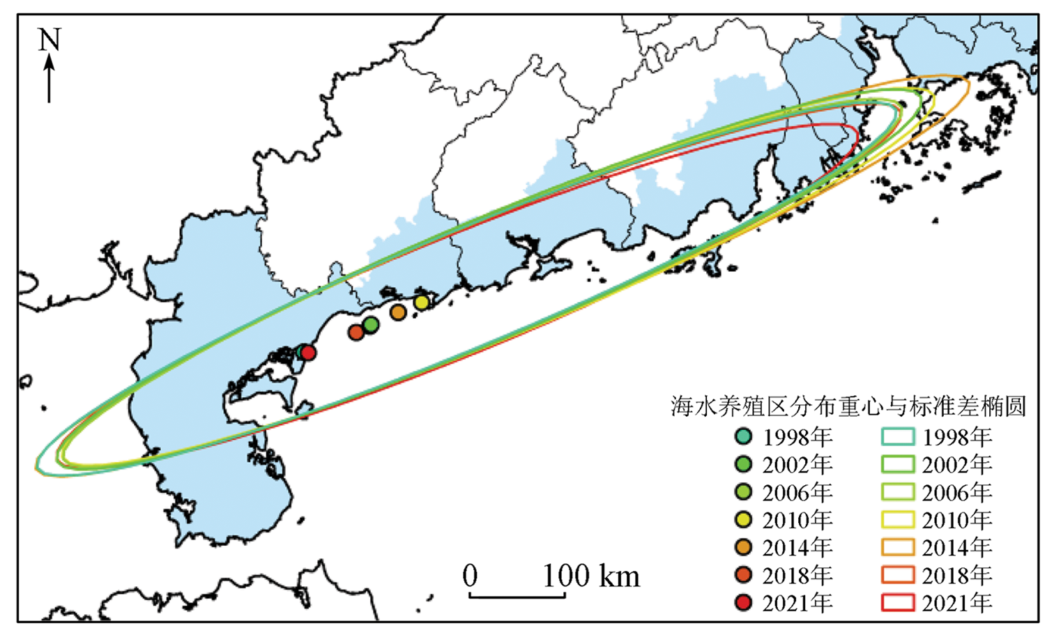
The mariculture industry occupies an important position in the marine economy of Guangdong Province. Timely and accurate knowledge of the spatial distribution and area changing trends of mariculture areas can greatly promote the sustainable development of the mariculture industry. Conventional interpretation methods for remote sensing images have problems of poor repeatability, low applicability, and high subjective arbitrariness. By contrast, the U-Net convolutional neural network, which belongs to the deep learning network model, can better extract the features of the object with higher extraction precision. Therefore, based on the multi-temporal Landsat TM/OLI remote sensing images, this study identified the mariculture areas (enclosed-sea and open-cage aquaculture areas) in Guangdong from 1998 to 2021 using the U-Net model as the interpretation model. The area trend analysis of mariculture areas was made. The changing characteristics of mariculture areas in terms of spatial distribution patterns were studied. The results are as follows. Compared with network models such as K-Means cluster analysis and DBN, the U-Net model with higher interpretation precision is more suitable for the interpretation of mariculture areas in Guangdong. The mariculture areas in Guangdong are mainly distributed in the western portion of Guangdong, such as Zhanjiang, Jiangmen, and Yangjiang. The mariculture areas in Guangdong can be classified into three levels in terms of area. They have small changes and keep a relatively stable state. The mariculture areas in Guangdong showed a spatial trend of outward expansion from 1998 to 2014 and inward contraction from 2014 to 2021. This study will provide data and technical support for the scientific management of the mariculture areas in Guangdong.
苏玮, 林阳阳, 岳文, 陈颖彪. 基于U-Net卷积神经网络的广东省海水养殖区识别及其时空变化遥感监测[J]. 自然资源遥感, 2022, 34(4): 33-41.
SU Wei, LIN Yangyang, YUE Wen, CHEN Yingbiao. Identification of mariculture areas in Guangdong Province and remote sensing monitoring of their spatial and temporal changes based on the U-Net convolutional neural network. Remote Sensing for Natural Resources, 2022, 34(4): 33-41.
Yang Z Y, Liu D, Peng L W. Green development of mariculture in China:Estimation,regional comparison and research on development strategy[J]. Ecological Economy, 2021, 37(11):128-135.
Huang W J, Yuan B. Competitiveness evaluation of China’s mariculture industry under the requirements of high-quality development[J]. Chinese Fisheries Economics, 2021, 39(4):60-67.
Zhai L, Sun Z Q, Wang B, et al. Study on development of China’s marine fisheries based on GM (1,1) model[J]. Jiangsu Agricultural Sciences, 2019, 47(13):342-346.
Zheng Z T, Fan H S, Wang J, et al. An improved double-branch network method for intelligently extracting marinecage culture area[J]. Remote Sensing for Land and Resources, 2020, 32(4):120-129.doi:10.6046/gtzyyg.2020.04.17.
doi: 10.6046/gtzyyg.2020.04.17
[5]
Oyinlola M A, Reygondeau G, Wabnitz C C C, et al. Global estimation of areas with suitable environmental conditions for mariculture species[J]. PLoS One, 2018, 13(1):e191086.
[6]
Feng Z H, Zhang T, Wang J X, et al. Spatio-temporal features of microplastics pollution in macroalgae growing in an important mariculture area,China[J]. Science of the Total Environment, 2020, 719:137490.
doi: 10.1016/j.scitotenv.2020.137490
Wu Y T, Chen F, Ma Y, et al. Research on automatic extraction method for coastal aquaculture area using Landsat8 data[J]. Remote Sensing for Land and Resources, 2018, 30(3):96-105.doi:10.6046/gtzyyg.2018.03.14.
doi: 10.6046/gtzyyg.2018.03.14
Yang Z W, Chen Y B, Wu Z F, et al. Spatial variability of urban thermal environment based on natural blocks[J]. Progress in Geography, 2019, 38(12):1944-1956.
doi: 10.18306/dlkxjz.2019.12.010
Li Y, Yuan L, Zhao Z Y, et al. Inversion of tidal flat topography based on unmanned aerial vehicle low-altitude remote sensing and field surveys[J]. Remote Sensing for Natural Resources, 2021, 33(3):80-88.doi:10.6046/zrzyyg.2020336.
doi: 10.6046/zrzyyg.2020336
Xu J P, Zhao J H, Zhang F S, et al. Object-oriented information extraction of pond aquaculture[J]. Remote Sensing for Land and Resources, 2013, 25(1):82-85.doi:10.6046/gtzyyg.2013.01.15.
doi: 10.6046/gtzyyg.2013.01.15
[11]
Wang Z H, Yang X M, Liu Y M, et al. Extraction of coastal raft cultivation area with heterogeneous water background by thresholding object-based visually salient NDVI from high spatial resolution imagery[J]. Remote Sensing Letters, 2018, 9(9):839-846.
doi: 10.1080/2150704X.2018.1468103
Wang F, Xia L H, Chen Z B, et al. Remote sensing identification of coastal zone mariculture modes based on association-rules object-oriented method[J]. Transactions of the Chinese Society of Agricultural Engineering, 2018, 34(12):210-217.
[14]
Lu Y M, Shao W, Sun J. Extraction of offshore aquaculture areas from medium-resolution remote sensing images based on deep learning[J]. Remote Sensing, 2021, 13(19):3854.
doi: 10.3390/rs13193854
[15]
Alom M Z, Yakopcic C, Hasan M, et al. Recurrent residual U-Net for medical image segmentation[J]. Journal of Medical Imaging, 2019, 6(1):014006.
[16]
Wei S S, Zhang H, Wang C, et al. Multi-temporal SAR data large-scale crop mapping based on U-Net model[J]. Remote Sensing, 2019, 11(1):68.
doi: 10.3390/rs11010068
[17]
Cui B G, Fei D, Shao G H, et al. Extracting raft aquaculture areas from remote sensing images via an improved U-Net with a PSE structure[J]. Remote Sensing, 2019, 11(17):2053.
doi: 10.3390/rs11172053
[18]
Falk T, Mai D, Bensch R, et al. U-Net:Deep learning for cell counting,detection,and morphometry[J]. Nature Methods, 2019, 16(1):67-70.
doi: 10.1038/s41592-018-0261-2
Yang R, Qi Y, Su Y. U-Net neural networks and its application in high resolution satellite image classification[J]. Remote Sensing Technology and Application, 2020, 35(4):767-774.
Yang Z W, Chen Y B, Qian Q L, et al. Evaluation of the matching degree of public medical service level based on population spatialization:A case study of Guangzhou[J]. Geography and Geo-Information Science, 2019, 35(2):74-82.
[21]
Nogueira K, Penatti O A B, Dos S J A. Towards better exploiting convolutional neural networks for remote sensing scene classification[J]. Pattern Recognition, 2017, 61:539-556.
doi: 10.1016/j.patcog.2016.07.001
[22]
Shao Z F, Zhou W X, Deng X Q, et al. Multilabel remote sensing image retrieval based on fully convolutional network[J]. IEEE Journal of Selected Topics in Applied Earth Observations and Remote Sensing, 2020, 13:318-328.
doi: 10.1109/JSTARS.2019.2961634
[23]
Freudenberg M, Nölke N, Agostini A, et al. Large-scale palm tree detection in high resolution satellite images using U-Net[J]. Remote Sensing, 2019, 11(3):312.
doi: 10.3390/rs11030312
[24]
Qin P, Cai Y L, Wang X L. Small waterbody extraction with improved U-Net using Zhuhai-1 hyperspectral remote sensing images[J]. IEEE Geoscience and Remote Sensing Letters, 2020, 19:1-5.
[25]
Liu Z Q, Cao Y W, Wang Y Z, et al. Computer vision-based concrete crack detection using U-Net fully convolutional networks[J]. Automation in Construction, 2019, 104:129-139.
doi: 10.1016/j.autcon.2019.04.005
[26]
Zhang Z, Wu C D, Coleman S, et al. DENSE-Inception U-Net for medical image segmentation[J]. Computer Methods and Programs in Biomedicine, 2020, 192:105395.
doi: 10.1016/j.cmpb.2020.105395
[27]
Ibtehaz N, Rahman M S. MultiResUNet:Rethinking the U-Net architecture for multimodal biomedical image segmentation[J]. Neural Networks, 2020, 121:74-87.
doi: S0893-6080(19)30250-3
pmid: 31536901
Yang Z W, Chen Y B, Zheng Z H, et al. Spatial accessibility and spatial distribution characteristics of A-grade tourist spots in Guangdong Province[J]. Geospatial Information, 2019, 17(6):51-55.
 2022, Vol. 34
  ), 林阳阳1, 岳文1(