A study on time lags between groundwater changes and land subsidence based on GRACE and InSAR data
WEI Xiaoqiang1,2(), YANG Guolin1,2,3(), LIU Tao1,2,3, SHAO Ming1,2, MA Zhigang1,2
1. Faculty of Geomatics, Lanzhou Jiaotong University, Lanzhou 730070, China 2. Gansu Provincial Engineering Laboratory for National Geographic State Monitoring, Lanzhou 730070, China 3. National -Local Joint Engineering Research Center of Technology and Application for National Geographic State Monitoring, Lanzhou 730070, China
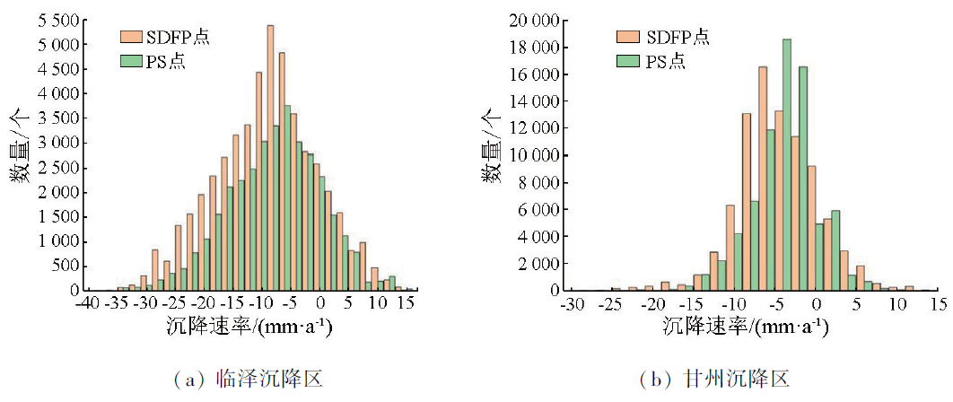
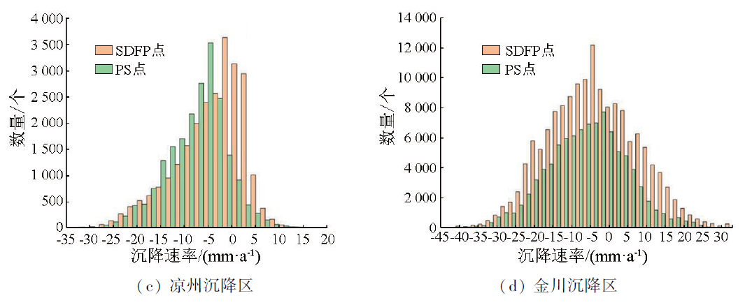
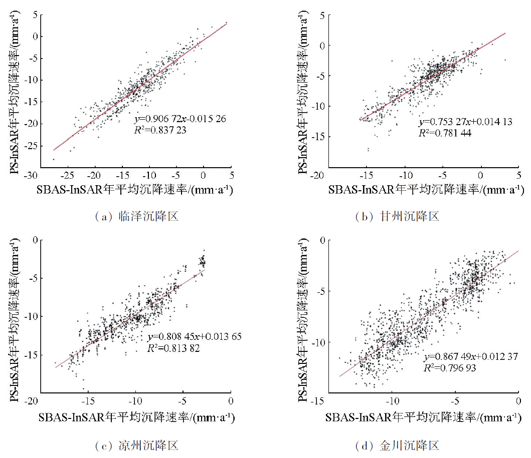
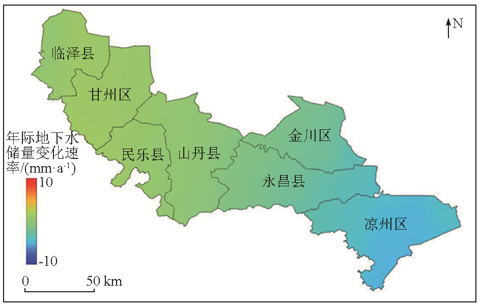
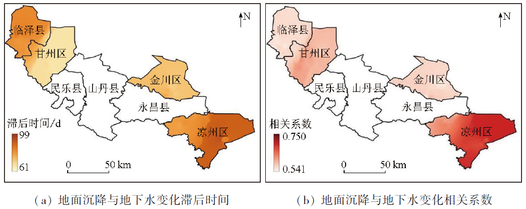
The increasing dependence on groundwater in the Hexi region has led to a significant drop in the groundwater table, which has induced land subsidence in some areas. Studying the relationship between groundwater changes and land subsidence hysteresis in the Hexi region holds great significance for local water resource management, land use planning, and agricultural development. This study determined the changing rate of groundwater in the study area from 2010 to 2017 using the GRACE and GLDAS data and verified the reliability of the inverted groundwater changes by combining measured data from monitoring wells. Then, this study derived the surface deformation rate of the local subsidence areas from October 2014 to June 2017 using the small baseline subset interferometric synthetic aperture radar (SBAS-InSAR) technique, as well as comparing and validating the results using the persistent scatterer interferometric synthetic aperture radar (PS-InSAR) technique. Finally, this study analyzed the relationship between groundwater changes and surface subsidence data using fast Fourier transform and time-delay correlation analysis. The results indicate that the time lags between land subsidence and groundwater changes were 74~86 d, 61~80 d, 80~99 d, and 74~99 d, respectively in the Linze, Ganzhou, Liangzhou, and Jinchuan subsidence areas, with respective correlation coefficients ranging from 0.541 to 0.593, from 0.589 to 0.689, from 0.600 to 0.750, and 0.543 to 0.630, respectively. The results of this study will provide a scientific basis for water resource management, land use planning, and agricultural development in the Hexi region.
魏小强, 杨国林, 刘涛, 邵明, 马志刚. 基于GRACE与InSAR数据地下水变化与地面沉降滞后性研究[J]. 自然资源遥感, 2025, 37(1): 122-130.
WEI Xiaoqiang, YANG Guolin, LIU Tao, SHAO Ming, MA Zhigang. A study on time lags between groundwater changes and land subsidence based on GRACE and InSAR data. Remote Sensing for Natural Resources, 2025, 37(1): 122-130.
Yu H R, Gong H L, Chen B B, et al. Emerging risks and the prospect of urban underground space security based on InSAR-GRACE satellite under the new hydrological background[J]. Remote Sen-sing for Land and Resources, 2020, 32(4):16-22.doi:10.6046/gtzyyg.2020.04.03.
[2]
Castellazzi P, Martel R, Galloway D L, et al. Assessing groundwater depletion and dynamics using GRACE and InSAR: Potential and limitations[J]. Ground Water, 2016, 54(6): 768-780.
doi: 10.1111/gwat.12453
pmid: 27576068
[3]
Castellazzi P, Longuevergne L, Martel R, et al. Quantitative mapping of groundwater depletion at the water management scale using a combined GRACE/InSAR approach[J]. Remote Sensing of Environment, 2018,205: 408-418.
[4]
Rodell M, Velicogna I, Famiglietti J S. Satellite-based estimates of groundwater depletion in India[J]. Nature, 2009, 460(7258): 999-1002.
Hu X Q, Yang S W, Yan H, et al. Time-series InSAR-based monitoring and analysis of surface deformation in the Axi mining area,Xinjiang[J]. Remote Sensing for Natural Resources, 2023, 35(1):171-179.doi:10.6046/zrzyyg.2021415.
Zhang Q J, Zhao Z, Jia L B, et al. Analysis of land subsidence status and influencing factors in Yellow River Delta[J]. Science of Surveying and Mapping, 2022, 47(12):165-173.
Yang W, He Y, Zhang L F, et al. InSAR monitoring of 3D surface deformation in Jinchuan mining area,Gansu Province[J]. Remote Sensing for Natural Resources, 2022, 34(1):177-188.doi:10.6046/zrzyyg.2021107.
[8]
Guo J, Zhou L, Yao C, et al. Surface subsidence analysis by multi-temporal InSAR and GRACE: A case study in Beijing[J]. Sensors, 2016, 16(9): 1495.
[9]
Vasco D W, Kim K H, Farr T G, et al. Using Sentinel-1 and GRACE satellite data to monitor the hydrological variations within the Tulare Basin,California[J]. Scientific Reports, 2022, 12(1): 3867.
[10]
Massoud E C, Liu Z, Shaban A, et al. Groundwater depletion signals in the Beqaa Plain,Lebanon:Evidence from GRACE and Sentinel-1 data[J]. Remote Sensing, 2021, 13(5): 915.
Fei T Z, Chang X T, Zhu G B, et al. Study on inversion of ground-water change and surface subsidence using GRACE and Sentinel-1[J]. Science of Surveying and Mapping, 2023, 48(1):140-147.
Li H Y, Li Y Y, Wang Y P, et al. Temporal and spatial differences and dynamic analysis of sandstorms in the west of Hexi Corridor[J]. Journal of Arid Land Resources and Environment, 2022, 36(10):104-112.
Li P P. Determination method and discussion of ground subsidence control area of groundwater overmining area in Gansu Province[J]. China Rural Water and Hydropower, 2019(6):74-77.
[14]
Zheng M, Deng K, Fan H, et al. Monitoring and analysis of surface deformation in mining area based on InSAR and GRACE[J]. Remote Sensing, 2018, 10(9):1392.
[15]
Wang Q, Zheng W, Yin W, et al. Improving the resolution of GRACE/InSAR groundwater storage estimations using a new subsidence feature weighted combination scheme[J]. Water, 2023, 15(6):1017.
[16]
Agarwal V, Kumar A, Gomes R L, et al. Monitoring of ground movement and groundwater changes in London using InSAR and GRACE[J]. Applied Sciences, 2020, 10(23):8599.
[17]
Khorrami M, Shirzaei M, Ghobadi-Far K, et al. Groundwater vo-lume loss in Mexico City constrained by InSAR and GRACE observations and mechanical models[J]. Geophysical Research Letters, 2023, 50(5): e2022GL101962.
[18]
Liu Z, Liu P W, Massoud E, et al. Monitoring groundwater change in California’s central valley using Sentinel-1 and GRACE observations[J]. Geosciences, 2019, 9(10):436.
[19]
Ferretti A, Prati C, Rocca F. Nonlinear subsidence rate estimation using permanent scatterers in differential SAR interferometry[J]. IEEE Transactions on Geoscience and Remote Sensing, 2000, 38(5): 2202-2212.
[20]
Berardino P, Fornaro G, Lanari R, et al. A new algorithm for surface deformation monitoring based on small baseline differential SAR interferograms[J]. IEEE Transactions on Geoscience and Remote Sensing, 2002, 40(11): 2375-2383.
Yang G L, Sun X X, Hu D, et al. Application of GRACE data in analysis on temporal and spatial changes of water reserves and drought characteristics of Qaidam Basin[J]. Journal of Navigation and Positioning, 2023, 11(1):107-112.
Wei Z F, Ren Z Y, Zhang C. Analysis on the time-lag correlation between vegetation and climatic factors:Take Guangxi as an example[J]. Ecology and Environmental Sciences, 2013, 22(11):1757-1762.
[23]
Hussain M A, Chen Z, Zheng Y, et al. PS-InSAR based monitoring of land subsidence by groundwater extraction for Lahore Metropolitan City,Pakistan[J]. Remote Sensing, 2022, 14(16):3950.
[24]
Béjar-Pizarro M, Ezquerro P, Herrera G, et al. Mapping groundwater level and aquifer storage variations from InSAR measurements in the Madrid aquifer,Central Spain[J]. Journal of Hydrology, 2017,547:678-689.
Fan J, Zuo X Q, Li T, et al. Analysis and comparison of PS-InSAR and SBAS-InSAR for ground subsidence monitoring in the main city of Kunming[J]. Engineering of Surveying and Mapping, 2018, 27(6):50-58.
 2025, Vol. 37
  ), 杨国林1,2,3(