|
|
 |
|

|
|
|
Land use classification of farming areas based on time series Sentinel-2A/B data and random forest algorithm |
WANG Dejun1( ), JIANG Qigang2, LI Yuanhua2, GUAN Haitao1, ZHAO Pengfei1, XI Jing2 ), JIANG Qigang2, LI Yuanhua2, GUAN Haitao1, ZHAO Pengfei1, XI Jing2 |
1. The Fifth Surveying Mapping and Geographic Information Engineering Institute of Heilongjiang Province, Harbin 150081, China
2. College of Geo-Exploration Science and Technology, Jilin University, Changchun 130026, China |
|
|
|
|
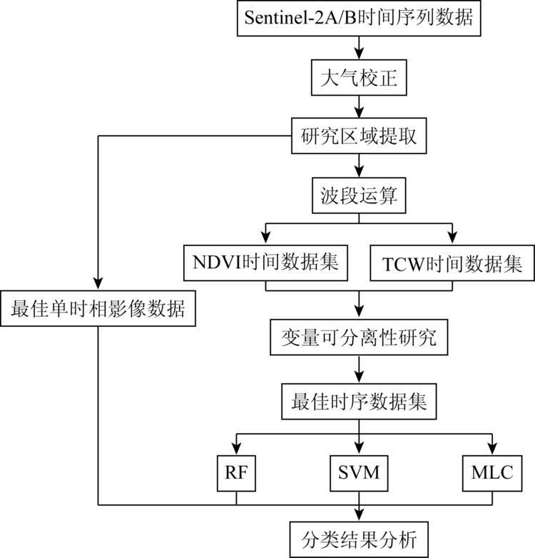
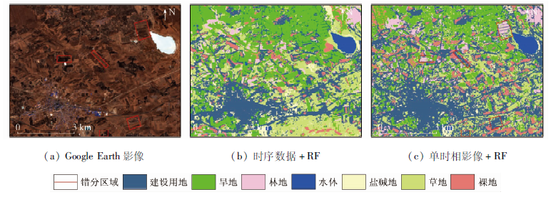
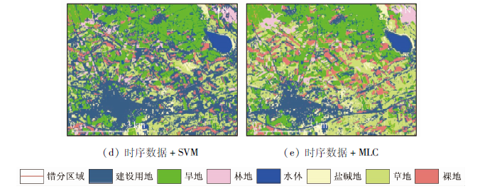
Abstract Land cover information in farming areas is the basis of land resource management and planning, which plays an important role in the rational development of land resources, adjustment of land use structure, and dynamic monitoring of land. Due to the complex land types and high heterogeneity in farming areas, the accuracy of land cover information extraction has been facing challenges. Therefore, this study used Sentinel-2A/B remote sensing data as the data source. Firstly, a normalized difference vegetation index (NDVI) time series data set and tasseled cap wetness (TCW) time series data set were constructed; Secondly, the J-M (Jeffries-Matusita) distance was used to analyze the separability of the surface features and select the best time series data combination of NDVI and TCW; Finally, combined with random forest (RF), support vector machine (SVM), maximum likelihood classification (MLC) and single phase remote sensing data, the classification of typical features in farming areas was studied, and the accuracy of classification results was evaluated and compared. The research results show that the classification accuracy of the time series data combined with the random forest classification algorithm is relatively high. The overall classification accuracy reaches 88.87%, and the Kappa coefficient reaches 0.855 7, which improves the classification accuracy by 10.05 percentage points and 0.209 3 respectively compared with that of the single remote sensing data. This fully demonstrates that the combination of time series data and random forest classification algorithm can effectively improve the classification accuracy of typical features in farming areas.
|
| Keywords
time series
random forest
land use classification
farming area
Sentinel-2A/B
|
|
|
|
Issue Date: 23 December 2020
|
|
|
| [1] |
张静, 张翔, 田龙, 等. 西北旱区遥感影像分类的支持向量机法[J]. 测绘科学, 2017,42(1):49-52,58.
|
| [1] |
Zhang J, Zhang X, Tian L, et al. The support vector machine method for RS images’ classification in northwest arid area[J]. Science of Surveying and Mapping, 2017,42(1):49-52,58.
|
| [2] |
马玥, 姜琦刚, 孟治国, 等. 基于随机森林算法的农耕区土地利用分类研究[J]. 农业机械学报, 2016,47(1):297-303.
|
| [2] |
Ma Y, Jiang Q G, Meng Z G, et al. Classification of land use in farming area based on random forest algorithm[J]. Transactions of the Chinese Society for Agricultural Machinery, 2016,47(1):297-303.
|
| [3] |
林楠, 姜琦刚, 杨佳佳, 等. 基于资源一号02C高分辨率数据的农业区土地利用分类[J]. 农业机械学报, 2015,46(1):278-284.
|
| [3] |
Lin N, Jiang Q G, Yang J J, et al. Classifications of agricultural land use based on high-spatial ZY1-02C remote sensing images[J]. Transactions of the Chinese Society for Agricultural Machinery, 2015,46(1):278-284.
|
| [4] |
王月如, 韩鹏鹏, 关舒婧, 等. 基于Landsat8 OLI数据的富贵竹种植区域信息提取[J]. 国土资源遥感, 2019,31(1):133-140.doi: 10.6046/gtzyyg.2019.01.08.
|
| [4] |
Wang Y R, Han P P, Guan S J, et al. Information extraction of Dracaena sanderiana planting area based on Landsat8 OLI data[J]. Remote Sensing for Land and Resources, 2019,31(1):133-140.doi: 10.6046/gtzyyg.2019.01.08.
|
| [5] |
Wardlow B D, Egbert S L. Large-area crop mapping using time-series MODIS 250 m NDVI data:An assessment for the U.S.Central Great Plains[J]. Remote Sensing of Environment, 2008,112(3):1096-1116.
|
| [6] |
Vintrou E, Desbrosse A, Bégué A, et al. Crop area mapping in West Africa using landscape stratification of MODIS time series and comparison with existing global land products[J]. International Journal of Applied Earth Observation and Geoinformation, 2012,14(1):83-93.
|
| [7] |
朱永森, 曾永年, 张猛. 基于HJ卫星数据与面向对象分类的土地利用/覆盖信息提取[J]. 农业工程学报, 2017,33(14):266-273.
|
| [7] |
Zhu Y S, Zeng Y N, Zhang M. Extract of land use/cover information based on HJ satellites data and object-oriented classification[J]. Transactions of the Chinese Society of Agricultural Engineering, 2017,33(14):266-273.
|
| [8] |
张猛, 曾永年. 基于多时相Landsat数据融合的洞庭湖区水稻面积提取[J]. 农业工程学报, 2015,31(13):178-185.
|
| [8] |
Zhang M, Zeng Y N. Mapping paddy fields of Dongting Lake area by fusing Landsat and MODIS data[J]. Transactions of the Chinese Society of Agricultural Engineering, 2015,31(13):178-185.
|
| [9] |
郝鹏宇, 牛铮, 王力, 等. 基于历史时序植被指数库的多源数据作物面积自动提取方法[J]. 农业工程学报, 2012,28(23):123-131,297.
url: http://www.tcsae.org/nygcxb/ch/reader/view_abstract.aspx?file_no=20122317&flag=1
|
| [9] |
Hao P Y, Niu Z, Wang L, et al. Multi-source automatic crop pattern mapping based on historical vegetation index profiles[J]. Transactions of the Chinese Society of Agricultural Engineering, 2012,28(23):123-131,297.
url: http://www.tcsae.org/nygcxb/ch/reader/view_abstract.aspx?file_no=20122317&flag=1
|
| [10] |
龚燃. 哨兵-2A光学成像卫星发射升空[J]. 国际太空, 2015(8):36-40.
|
| [10] |
Gong R. Sentinel-2A optical imaging satellite launched[J]. Space International, 2015(8):36-40.
|
| [11] |
范唯唯. Sentinel-2B卫星发射成功[J]. 空间科学学报, 2017,37(4):371-372.
|
| [11] |
Fan W W. Sentinel-2B satellite launched successfully[J]. Chinese Journal of Space Science, 2017,37(4):371-372.
|
| [12] |
吴静, 吕玉娜, 李纯斌, 等. 基于多时相Sentinel-2A的县域农作物分类[J]. 农业机械学报, 2019,50(9):194-200.
|
| [12] |
Wu J, Lyu Y N, Li C B, et al. Fine classification of county crops based on multi-temporal images of Sentinel-2A[J]. Transactions of the Chinese Society for Agricultural Machinery, 2019,50(9):194-200.
|
| [13] |
Belgiu M, Drguţ L. Random forest in remote sensing:A review of applications and future directions[J]. ISPRS Journal of Photogrammetry and Remote Sensing, 2016,114:24-31.
|
| [14] |
赵理君, 唐娉. 典型遥感数据分类方法的适用性分析——以遥感图像场景分类为例[J]. 遥感学报, 2016,20(2):157-171.
|
| [14] |
Zhao L J, Tang P. Scalability analysis of typical remote sensing data classification methods:A case of remote sensing image scene[J]. Journal of Remote Sensing, 2016,20(2):157-171.
|
| [15] |
喻小倩, 刘娜, 李红, 等. 基于线性光谱混合分解和最大似然分类相结合的土地覆被分类——以红寺堡灌区为例[J]. 国土资源遥感, 2010,22(1):96-100.doi: 10.6046/gtzyyg.2010.01.08.
|
| [15] |
Yu X Q, Liu N, Li H, et al. Land cover classification based on linear spectral mixture decomposition combined with maximum likelihood classfication:A case study of Hongsipu Irrigation Area[J]. Remote Sensing for Land and Resources, 2010,22(1):96-100.doi: 10.6046/gtzyyg.2010.01.08.
|
| [16] |
程红芳, 章文波, 陈锋. 植被覆盖度遥感估算方法研究进展[J]. 国土资源遥感, 2008,20(1):13-18.doi: 10.6046/gtzyyg.2008.01.02.
|
| [16] |
Cheng H F, Zhang W B, Chen F. Advances in researches on application of remote sensing method to estimating vegetation coverage[J]. Remote Sensing for Land and Resources, 2008,20(1):13-18.doi: 10.6046/gtzyyg.2008.01.02.
|
| [17] |
罗开盛, 陶福禄. 融合面向对象与缨帽变换的湿地覆被类别遥感提取方法[J]. 农业工程学报, 2017,33(3):198-203.
|
| [17] |
Luo K S, Tao F L. Method for wetland type extraction using remote sensing combing obiect-oriented and tasseled cap transformation[J]. Transactions of the Chinese Society of Agricultural Engineering, 2017,33(3):198-203.
|
| [18] |
Wittke S, Yu X, Karjalainen M, et al. Comparison of two-dimensional multitemporal Sentinel-2 data with three-dimensional remote sensing data sources for forest inventory parameter estimation over a boreal forest[J]. International Journal of Applied Earth Observation and Geoinformation, 2019,76:167-178.
|
| [19] |
Sun Z P, Shen W M, Wei B, et al. Object-oriented land cover classification using HJ-1 remote sensing imagery[J]. Science China Earth Sciences, 2010,53(1):34-44.
doi: 10.1007/s11430-010-4133-6
url: http://link.springer.com/10.1007/s11430-010-4133-6
|
| [20] |
王长耀, 刘正军, 颜春燕. 成像光谱数据特征选择及小麦品种识别实验研究[J]. 遥感学报, 2006,10(2):249-255.
doi: 10.11834/jrs.20060237
url: http://www.jors.cn/jrs/ch/reader/view_abstract.aspx?file_no=20060237&flag=1
|
| [20] |
Wang C Y, Liu Z J, Yan C Y. A experimental study on imaging spectrometer data feature selection and wheat type identification[J]. Journal of Remote Sensing, 2006,10(2):249-255.
doi: 10.11834/jrs.20060237
url: http://www.jors.cn/jrs/ch/reader/view_abstract.aspx?file_no=20060237&flag=1
|
| [21] |
Breiman L. Random forests[J]. Machine Learning, 2001,45(1):5-32.
doi: 10.1023/A:1010933404324
url: http://www.springerlink.com/content/u0p06167n6173512/
|
| [22] |
Adam E, Mutanga O. Spectral discrimination of papyrus vegetation (Cyperus papyrus L.) in swamp wetlands using field spectrometry[J]. ISPRS Journal of Photogrammetry and Remote Sensing, 2009,64(6):612-620.
|
| [23] |
刘舒, 姜琦刚, 马玥, 等. 基于多目标遗传随机森林特征选择的面向对象湿地分类[J]. 农业机械学报, 2017,48(1):119-127.
|
| [23] |
Liu S, Jiang Q G, Ma Y, et al. Object-oriented wetland classification based on hybrid feature selection method combining with Relief F,multi-objective genetic algorithm and random forest[J]. Transactions of the Chinese Society for Agricultural Machinery, 2017,48(1):119-127.
|
| [24] |
何云, 黄翀, 李贺, 等. 基于Sentinel-2A影像特征优选的随机森林土地覆盖分类[J]. 资源科学, 2019,41(5):992-1001.
doi: 10.18402/resci.2019.05.15
url: http://www.resci.cn/CN/volumn/home.shtml/CN/abstract/abstract43213.shtml
|
| [24] |
He Y, Huang C, Li H, et al. Land-cover classification of random forest based on Sentinel-2A image feature optimization[J]. Resources Science, 2019,41(5):992-1001.
doi: 10.18402/resci.2019.05.15
url: http://www.resci.cn/CN/volumn/home.shtml/CN/abstract/abstract43213.shtml
|
|
Viewed |
|
|
|
Full text
|
|
|
|
|
Abstract
|
|
|
|
|
Cited |
|
|
|
|
| |
Shared |
|
|
|
|
| |
Discussed |
|
|
|
|
 2020,
Vol. 32
2020,
Vol. 32