|
|
|
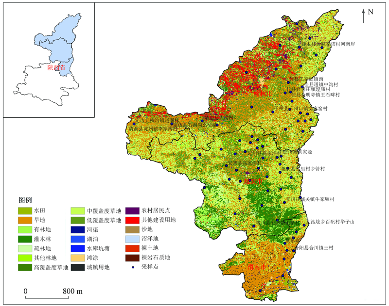
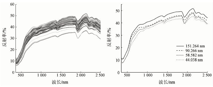
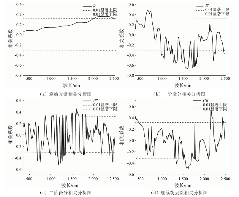
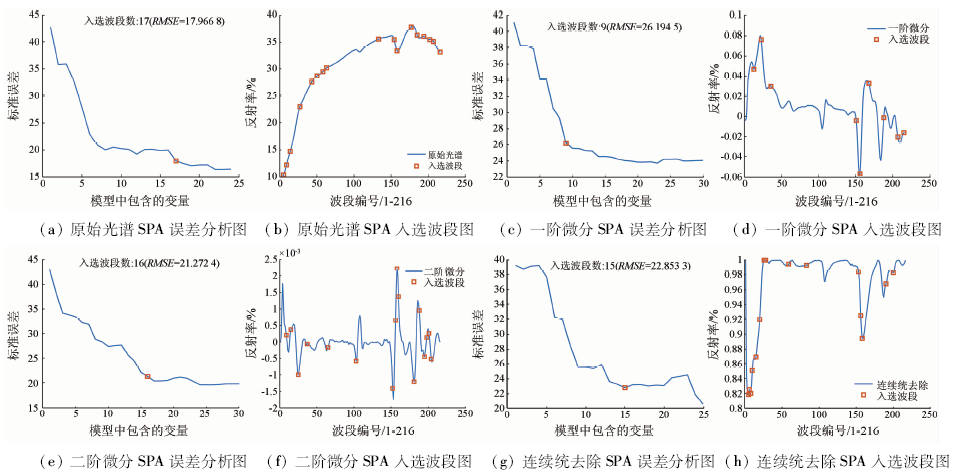
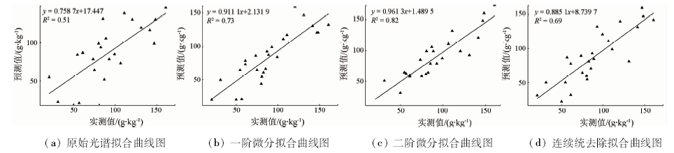
Abstract Carbonate content in soil is an important basis for soil classification and fertility evaluation. Based on an analysis of calcium carbonate content, the authors chose 78 soil samples from Loess Plateau of Shaanxi Province as the research objects. The visible near infrared hyperspectral reflectance (350~2 500 nm) data of soil samples were obtained by hyperspectral imager. Three mathematical transformations, i.e., first-order differentiation, second-order differentiation and continuum removal, were carried out on the original spectral curve, and correlation analysis was used. The method and the continuous projection algorithm were used to select the sensitive band respectively, and the Stochastic Forest regression was used to establish the estimation model of soil calcium carbonate. According to the results obtained, the spectral curve characteristics of Huangmian soil are almost the same, there are obvious absorption characteristics at 1 440 nm, 1 900 nm, 2 200 nm and so on, and the calcium carbonate content and spectral reflectance show a positive correlation trend; the accuracy of random forest estimation model based on the second-order differential and continuous projection algorithm is the highest, the validation set R 2 is 0.82, and the PRD value is 2.37.
|
| Keywords
calcium carbonate
Huangmian soil
hyperspectral
continuous projection algorithm
random forest regression
|
|
|
|
Corresponding Authors:
JIANG Qigang
E-mail: 1148545835@qq.com;jiangqigang@jlu.edu.cn
|
|
Issue Date: 18 March 2021
|
|
|
| [1] |
赵其国, 史学正. 土壤资源概论[M]. 北京: 科学出版社科学, 2017: 15-20.
|
| [1] |
Zhao Q G, Shi X Z. Introduction to soil resources[M]. Beijing: Science Press, 2017: 15-20.
|
| [2] |
陈留美, 张甘霖. 滨海沉积物发育的水稻土时间序列母质均一性判定与特性演变[J]. 土壤学报, 2009,46(5):753-763.
|
| [2] |
Chen L M, Zhang G L. Determination of parent material homogeneity and evolution of characteristics of paddy soils developed in coastal sediments[J]. Soil Journal, 2009,46(5):753-763.
|
| [3] |
张宁, 何兴东, 邬畏. 腾格里沙漠3种土壤有机质和碳酸钙特征[J]. 生态学报, 2009,29(8):4095-4101.
|
| [3] |
Zhang N, He X D, Wu W. Characteristics of organic matter and calcium carbonate in three soils of Tengger Desert[J]. Acta Ecologica, 2009,29(8):4095-4101.
|
| [4] |
童庆禧, 张兵, 张立福. 中国高光谱遥感的前沿进展[J]. 遥感学报, 2016,20(5):689-707.
|
| [4] |
Tong Q X, Zhang B, Zhang L F. Current progress of hyperspectral remote sensing in China[J]. Journal of Remote Sensing, 2016,20(5):689-707.
|
| [5] |
Gaffey S J. Spectral reflectance of carbonate minerals in visible and near infrared(0.35~2.55 μm):A nhydrous carbonate minerals[J]. Journal of Geophysical Research, 1987,92:1429— 1440.
|
| [6] |
张婷婷. 基于PLS模型的农业土壤成分高光谱遥感反演研究[D]. 长春:吉林大学, 2010.
|
| [6] |
Zhang T T. Partial least squares modeling of hyperspectral remote sensing for mapping agricultural soil properties[D]. Changchun:Jilin University, 2010.
|
| [7] |
Stenberg B, Viscarra Rossel R A, Mouazen A M, et al. Visible and near infrared spectroscopy in soil science[J]. Advances in A gronomy, 2010,107:163— 215.
|
| [8] |
Sexton J, Laake P. Standard errors for bagged and random forest estimators[J]. Computational Statistics & Data Analysis, 2009,53(3):801-811.
|
| [9] |
宋建国, 高强山, 李哲. 随机森林回归在地震储层预测中的应用[J]. 石油地球物理勘探, 2016,51(6):1203-1211.
|
| [9] |
Song J G, Gao Q S, Li Z. Application of stochastic forest regression in seismic reservoir prediction[J]. Petroleum Geophysical Exploration, 2016,51(6):1203-1211.
|
| [10] |
秦倩如. 基于高光谱的陕西省土壤游离铁与碳酸钙含量预测研究[D]. 杨凌:西北农林科技大学, 2019.
|
| [10] |
Qin Q R. Prediction of soil free iron and calcium carbonate content based on hyperspectral data in Shaanxi Province[D]. Yang Ling:Northwest Agricultural and Forestry University of Science and Technology, 2019.
|
| [11] |
单海滨, 蒋平安, 颜安, 等. 基于高光谱的北疆绿洲农田灰漠土有机质反演[J]. 农业资源与环境学报, 2018,35(3):276-282.
|
| [11] |
Shan H B, Jiang P A, Yan A, et al. Hyperspectral retrieval of organic matter in grey desert soil of oasis farmland in Northern Xinjiang[J]. Journal of Agricultural Resources and Environment, 2018,35(3):276-282.
|
| [12] |
Araújo M C U, Saldanha T C B, Galvão R K H, et al. The successive projections algorithm for variable selection in spectroscopic multicomponent analysis[J]. Chemometrics and Intelligent Laboratory Systems, 2001,57(2):65-73.
|
| [13] |
杨红云, 周琼, 杨珺, 等. 基于高光谱的水稻叶片氮素营养诊断研究[J]. 浙江农业学报, 2019,31(10):1575-1582.
|
| [13] |
Yang H Y, Zhou Q, Yang J, et al. Hyperspectral diagnosis of nitrogen nutrition in rice leaves[J]. Zhejiang Journal of Agriculture, 2019,31(10):1575-1582.
|
| [14] |
李勋兰, 易时来, 何绍兰, 等. 高光谱成像技术的柚类品种鉴别研究[J]. 光谱学与光谱分析, 2015,35(9):2639-2643.
pmid: 26669182
|
| [14] |
Li X L, Yi S L, He S L, et al. Identification of pummelo cultivars based on hyperspectral imaging technology[J]. Spectroscopy and Spectral Analysis, 2015,35(9):2639-2643.
pmid: 26669182
url: https://www.ncbi.nlm.nih.gov/pubmed/26669182
|
| [15] |
秦倩如, 齐雁冰, 吴娟, 等. 基于高光谱的土壤游离铁随机森林模型估算研究[J]. 土壤通报, 2018,49(6):1286-1293.
|
| [15] |
Qin Q R, Qi Y B, Wu J, et al. Estimation of soil free iron random forest model based on hyperspectral data[J]. Soil Bulletin, 2018,49(6):1286-1293.
|
| [16] |
彭杰, 周清, 张杨珠, 等. 有机质对土壤光谱特性的影响研究[J]. 土壤学报, 2013,50(3):517-524.
|
| [16] |
Peng J, Zhou Q, Zhang Y Z, et al. Effect of soil organic m atter on spectral characteristics of soil[J]. Acta Pedologica Sinica, 2013,50(3):517-524.
|
| [17] |
洪长桥, 郑光, 陈昌春. 苏北滨海土壤碳酸钙含量反射光谱估算研究[J]. 土壤学报, 2016,53(5):1121-1129.
|
| [17] |
Hong C Q, Zheng G, Chen C C. Study on reflectance spectrum estimation of calcium carbonate content in coastal soil of Northern Jiangsu[J]. Journal of Soil Science, 2016,53(5):1121-1129.
|
| [18] |
张东, 张飞, 等. 分数阶微分在盐渍土高光谱数据预处理中的应用[J]. 农业工程学报, 2014,30(24):151-160.
|
| [18] |
Zhang D, Zhang F, et al. Application of fractional differential in preprocessing hyperspec-tral data of saline soil[J]. Transactions of the Chinese Society of Agricultural Engineering, 2014,30(24):151-160.
|
| [19] |
Gomez C, Philippe L, Guillaume C. Continuum removal versus PLSR method for clay and calcium carbonate content estimation from laboratory and airborne hyperspectral measurements[J]. Geoderma, 2008,148(2):141-148.
|
|
Viewed |
|
|
|
Full text
|
|
|
|
|
Abstract
|
|
|
|
|
Cited |
|
|
|
|
| |
Shared |
|
|
|
|
| |
Discussed |
|
|
|
|
 2021,
Vol. 33
2021,
Vol. 33
 ), JIANG Qigang(