|
|
 |
|

|
|
|
Dynamic evaluation and prediction of ecological environment vulnerability in the middle-upper reaches of the Yalong River |
YAO Kun1( ), ZHANG Cunjie2(), HE Lei3, LI Yuxia4, LI Xiaoju5 ), ZHANG Cunjie2(), HE Lei3, LI Yuxia4, LI Xiaoju5 |
1. College of Resource and Environment, Xichang University, Xichang 615000, China
2. National Climate Center, Beijing 100081, China
3. School of Software Engineering, Chengdu University of Information Technology, Chengdu 610103, China
4. School of Automation Engineering, University of Electronic Science and Technology of China, Chengdu 610054, China
5. Engineering College, Universitiy Putra Malaysia, Kuala Lumpur 43400, Malaysia |
|
|
|
|
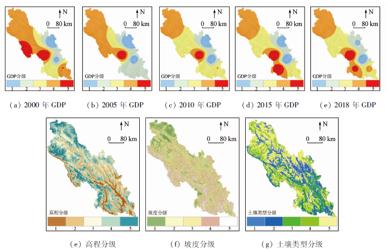
Abstract In order to timely grasp the changes and future development of the ecological environment vulnerability, the authors selected 9 indicators, such as elevation, slope and land use type. Combining RS and GIS technology with AHP-PCA entropy weight model, the authors evaluated the vulnerability of the region in 2000—2018 dynamically, and introduced CA-Markov model for the development of 2021 simulation prediction. The following results have been achieved: ①The overall vulnerability of the region shows gradual decrease in gradient from north to south. ②The degree of vulnerability shows a gradual decrease in the proportion of micro, light, potential, moderate and severe grids. ③CA-Markov is not only suitable for predicting ecological vulnerability in the region, but also with high accuracy, and the proportion of potential, micro, mild, moderate and severe grids in 2021 is 20.18%, 38.02%, 25.71%, 10.96% and 5.13% respectively. ④Throughout the study period, the region’s vulnerability composite index is 2.539 2, 2.501 6, 2.485 6 , 2.460 7 and 2.436 6, respectively, and the 2021 value is 2.428 5. The continuous decrease of this value indicates that the overall ecological environment of the region has been effectively improved and will be in a state of change with sustained and good development. The study effectively reveals the law of dynamic change of ecological environment vulnerability in middle-upper reaches of the Yalong River Basin. With a more scientific analysis of its main drivers and future development, it can be used as an important theoretical reference for the formulation of ecological protection measures in the region.
|
| Keywords
RS
GIS
AHP-PCA entropy model
CA-Markov model
the middle-upper reaches of the Yalong River Basin
|
|
|
|
Corresponding Authors:
ZHANG Cunjie
E-mail: jiangshan996@126.com;zhangcj@cma.gov.cn
|
|
Issue Date: 23 December 2020
|
|
|
| [1] |
张笑楠, 王克林, 张伟, 等. 桂西北喀斯特区域生态环境脆弱性[J]. 生态学报, 2009,29(2):749-757.
|
| [1] |
Zhang X N, Wang K L, Zhang W, et al. The quantitative assessment of eco-environment vulnerability in Karst regions of northwest Guangxi[J]. Acta Ecologica Sinica, 2009,29(2):749-757.
|
| [2] |
韦晶, 郭亚敏, 孙林, 等. 三江源地区生态环境脆弱性评价[J]. 生态学杂志, 2015,34(7):1968-1975.
url: http://www.cje.net.cn/CN/abstract/abstract7589.shtml
|
| [2] |
Wei J, Guo Y M, Sun L, et al. Evaluation of ecological environment vulnerability for Sanjiangyuan area[J]. Chinese Journal of Ecology, 2015,34(7):1968-1975.
url: http://www.cje.net.cn/CN/abstract/abstract7589.shtml
|
| [3] |
谢人栋, 赵翠薇. 基于栅格尺度的喀斯特槽谷区生态环境脆弱性时空分异研究[J]. 长江科学院院报, 2018,35(4):48-53.
|
| [3] |
Xie R D, Zhao C W. Spatio-temporal differentiation of ecological environment vulnerability in Karst trough region based on grid scale[J]. Journal of Yangtze River Scientific Research Institute, 2018,35(4):48-53.
|
| [4] |
林金煌, 胡国建, 祁新华, 等. 闽三角城市群生态环境脆弱性及其驱动力[J]. 生态学报, 2018,38(12):4155-4166.
|
| [4] |
Lin J H, Hu G J, Qi X H, et al. Ecological environmental vulnerability and its driving forces in urban agglomeration in the Fujian Delta region[J]. Acta Ecologica Sinica, 2018,38(12):4155-4166.
|
| [5] |
邵秋芳, 彭培好, 黄洁, 等. 长江上游安宁河流域生态环境脆弱性遥感监测[J]. 国土资源遥感, 2016,28(2):175-181.doi: 10.6046/gtzyyg.2016.02.27.
|
| [5] |
Shao Q F, Peng P H, Huang J, et al. Monitoring eco-environmental vulnerability in Anning River Basin in the upper reaches of the Yangtze River using remote sensing techniques[J]. Remote Sensing for Land and Resources, 2016,28(2):175-181.doi: 10.6046/gtzyyg.2016.02.27.
|
| [6] |
田超, 杨夏捷, 鞠园华, 等. 吉林省西部地区生态脆弱性的动态评价[J]. 水土保持研究, 2018,25(4):298-303.
|
| [6] |
Tian C, Yang X J, Ju Y H, et al. Dynamic evaluation of ecological vulnerability in western Jilin Province[J]. Research of Soil and Water Conservation, 2018,25(4):298-303.
|
| [7] |
郭梦迪, 韩继冲, 施玥, 等. 基于DPRISM概念框架的生态环境脆弱性评价——以岷江上游为例[J]. 物探化探计算技术, 2019,41(1):128-134.
|
| [7] |
Guo M D, Han J C, Shi Y, et al. Assessment of eco-environmental vulnerability based on DPRISM conceptual framework:A case study of upper Minjiang River[J]. Compute Techniques for Geophysical and Geochemical Exploration, 2019,41(1):128-134.
|
| [9] |
张梅, 罗怀良, 陈林. 资源型城市脆弱性评价——以攀枝花市为例[J]. 长江流域资源与环境, 2018,27(5):1170-1178.
|
| [9] |
Zhang M, Luo H L, Chen L. Vulnerability assessment of resource-based city:A case study of Panzhihua[J]. Resources and Environment in the Yangtze Basin, 2018,27(5):1170-1178.
|
| [10] |
仙巍, 李涛, 邵怀勇. 基于SVM的安宁河流域生态环境脆弱性评价[J]. 环境科学与技术, 2014,37(11):180-184.
|
| [10] |
Xian W, Li T, Shao H Y. Ecological frangibility evaluation of Anning River Basin in the Upper Yangtze River based on support vector machine[J]. Environmental Science and Technology, 2014,37(11):180-184.
|
| [11] |
陈金月, 王石英. 岷江上游生态环境脆弱性评价[J]. 长江流域资源与环境, 2017,26(3):471-479.
|
| [11] |
Chen J Y, Wang S Y. Ecological environment vulnerability assessment in upper reaches of Minjiang River[J]. Resources and Environment in the Yangtze Basin, 2017,26(3):471-479.
|
| [12] |
杨斌, 詹金凤, 李茂娇. 岷江上游流域环境脆弱性评价[J]. 国土资源遥感, 2014,26(4):138-144.doi: 10.6046/gtzyyg.2014.04.22.
|
| [12] |
Yang B, Zhan J F, Li M J. Evaluation of environmental vulnerability in the upper reaches of the Minjiang River[J]. Remote Sensing for Land and Resources, 2014,26(4):138-144.doi: 10.6046/gtzyyg.2014.04.22.
|
| [13] |
王志杰, 苏嫄. 南水北调中线汉中市水源地生态脆弱性评价与特征分析[J]. 生态学报, 2018,38(2):432-442.
|
| [13] |
Wang Z J, Su Y. Analysis of eco-environmental vulnerability characteristics of Hanzhong City,near the water source midway along the route of the south-to-north water transfer project,China[J]. Acta Ecologica Sinica, 2018,38(2):432-442.
|
| [14] |
姚建, 丁晶, 艾南山. 岷江上游生态脆弱性评价[J]. 长江流域资源与环境, 2004(4):380-383.
|
| [14] |
Yao J, Ding J, Ai N S. Assessment ecological vulnerability in the upper reaches of the Minjiang River[J]. Resources and Environment in the Yangtze Basin, 2004(4):380-383.
|
| [15] |
钟晓娟, 孙保平, 赵岩, 等. 基于主成分分析的云南省生态脆弱性评价[J]. 生态环境学报, 2011,20(1):109-113.
|
| [15] |
Zhong X J, Sun B P, Zhao Y, et al. Ecological vulnerability evaluation based on principal component analysis in Yunnan Province[J]. Ecology and Environmental Sciences, 2011,20(1):109-113.
|
| [16] |
刘正佳, 于兴修, 李蕾, 等. 基于SRP概念模型的沂蒙山区生态环境脆弱性评价[J]. 应用生态学报, 2011,22(8):2084-2090.
pmid: 22097371
|
| [16] |
Liu Z J, Yu X X, Li L, et al. Vulnerability assessment of eco-environment in Yimeng Mountainous area of Shandong Province based on SRP conceptual model[J]. Chinese Journal of Applied Ecology, 2011,22(8):2084-2090.
pmid: 22097371
url: https://www.ncbi.nlm.nih.gov/pubmed/22097371
|
| [17] |
Shao H, Liu M, Shao Q, et al. Research on eco-environmental vulnerability evaluation of the Anning River Basin in the upper reaches of the Yangtze River[J]. Environmental Earth Sciences, 2014,72(5):1555-1568.
|
| [18] |
Shao H, Sun X, Tao S, et al. Environmental vulnerability assessment in middle-upper reaches of Dadu River watershed using projection pursuit model and GIS[J]. Carpathian Journal of Earth and Environmental Sciences, 2015,10(4):143-146.
|
| [19] |
Shao H, Sun X, Wang H, et al. A method to the impact assessment of the returning grazing land to grassland project on regional eco-environmental vulnerability[J]. Environmental Impact Assessment Review, 2016,56:155-167.
|
| [20] |
王晓, 牛玉欣, 李杨. 基于熵权计算的公路生态环境评价[J]. 西南大学学报(自然科学版), 2010,32(9):168-172.
|
| [20] |
Wang X, Niu Y X, Li Y. Entropy weight-based evaluation of ecological environment along highways[J]. Journal of Southwest University (Natural Science Edition), 2010,32(9):168-172.
|
| [21] |
牛玉欣, 许金良, 杨宏志, 等. GIS支持下的公路生态环境评价[J]. 重庆大学学报, 2010,33(9):126-131.
|
| [21] |
Niu Y X, Xu J N, Yang H Z, et al. GIS-based eco- environmental quality evaluation of highway[J]. Journal of Chongqing University, 2010,33(9):126-131.
|
| [22] |
欧定华, 夏建国, 欧晓芳. 基于GIS和RBF的城郊区生态安全评价及变化趋势预测——以成都市龙泉驿区为例[J]. 地理与地理信息科学, 2017,33(1):49-58.
|
| [22] |
Ou D H, Xia J G, Ou X F. Regional ecological security assessment and change trend prediction in per-urban areas based on GIS and RBF:A case study in Longquanyi District of Chengdu City[J]. Geo-graphy and Geo-Information Science, 2017,33(1):49-58.
|
| [23] |
靳毅, 蒙吉军. 生态脆弱性评价与预测研究进展[J]. 生态学杂志, 2011,30(11):2646-2652.
|
| [23] |
Jin Y, Meng J J. Assessment and forecast of ecological vulnerability:A review[J]. Chinese Journal of Ecology, 2011,30(11):2646-2652.
|
| [24] |
张晓娟, 周启刚, 王兆林, 等. 基于MCE-CA-Markov的三峡库区土地利用演变模拟及预测[J]. 农业工程学报, 2017,33(19):268-277.
|
| [24] |
Zhang X J, Zhou Q G, Wang Z L, et al. Simulation and prediction of land use change in Three Gorges Reservoir Area based on MCE-CA-Markov[J]. Transactions of the Chinese Society of Agricultural Engineering, 2017,33(19):268-277.
|
| [25] |
李峰, 刘小阳, 于雪涛, 等. 基于AHP-PCA模型的煤炭城市生态环境质量评价[J]. 矿业安全与环保, 2017,44(5):103-106,110.
|
| [25] |
Li F, Liu X Y, Yu X T, et al. Eco-environmental quality evaluation of coal city based on AHP-PCA model[J]. Mining Safety and Environmental Protection, 2017,44(5):103-106,110.
|
| [26] |
夏兴生, 朱秀芳, 李月臣, 等. 基于AHP-PCA熵组合权重模型的三峡库区(重庆段)农业生态环境脆弱性评价[J]. 南方农业学报, 2016,47(4):548-556.
|
| [26] |
Xia X S, Zhu X F, Li Y C, et al. Evaluation for vulnerability of agroecological environment in Three Gorges Reservoir area(Chongqing section)based on AHP-PCA entropy combination weight mode[J]. Journal of Southern Agriculture, 2016,47(4):548-556.
|
| [27] |
陈朝亮, 彭树宏, 钱静, 等. 基于AHP-Logistic熵权模型的西南浅丘区地质灾害分布特征研究——以内江市为例[J]. 长江科学院院报, 2020,37(2):55-61.
|
| [27] |
Chen Z L, Peng S H, Qian J, et al. Distribution characteristics of geological hazards in southwestern shallow hill based on AHP-Logistic entropy combined weight model:A case study of Neijiang[J]. Journal of Yangtze River Scientific Research Institute, 2020,37(2):55-61.
|
| [28] |
侯成成, 赵雪雁, 张丽, 等. 基于熵组合权重属性识别模型的草原生态安全评价——以甘南黄河水源补给区为例[J]. 干旱区资源与环境, 2012,26(8):44-51.
|
| [28] |
Hou C C, Zhao X Y, Zhang L, et al. Ecological security evaluation of grassland based on combined weight on principle of relative entropy:A case of Yellow River water source areas of Gannan[J]. Journal of Arid Land Resources and Environment, 2012,26(8):44-51.
|
| [29] |
吴开亚, 金菊良. 区域生态安全评价的熵组合权重属性识别模型[J]. 地理科学, 2008,28(6):754-758.
url: http://geoscien.neigae.ac.cn/CN/abstract/abstract8777.shtml
|
| [29] |
Wu K Y, Jin J L. Attribute recognition method of regional ecological security evaluation based on combined weight on principle of relative entropy[J]. Scientia Geographica Sinica, 2008,28(6):754-758.
url: http://geoscien.neigae.ac.cn/CN/abstract/abstract8777.shtml
|
| [30] |
四川省人民政府. 四川省“十三五”生态保护与建设规划[EB/OL].[2017-04-19]. http://www.sc.gov.cn/zcwj/xxgk/NewT.aspx?i=20170421084123-670731-00-000.
url: http://www.sc.gov.cn/zcwj/xxgk/NewT.aspx?i=20170421084123-670731-00-000
|
| [30] |
Sichuan Provincial People’s Government. Sichuan Province’s “13th Five-Year Plan” for ecological protection and construction[EB/OL].[2017-04-19]. http://www.sc.gov.cn/zcwj/xxgk/NewT.aspx?i=20170421084123-670731-00-000.
url: http://www.sc.gov.cn/zcwj/xxgk/NewT.aspx?i=20170421084123-670731-00-000
|
| [31] |
谭剑波, 李爱农, 雷光斌. 青藏高原东南缘气象要素Anusplin和Cokriging空间插值对比分析[J]. 高原气象, 2016,35(4):875-886.
doi: 10.7522/j.issn.1000-0534.2015.00037
url: http://gyqx.westgis.ac.cn/CN/abstract/abstract6086.shtml
|
| [31] |
Tan J B, Li A N, Lei G B. Contrast on Anusplin and Cokriging meteorological spatial interpolation in southeastern margin of Qinghai-Xizang Plateau[J]. Plateau Meteorology, 2016,35(4):875-886.
doi: 10.7522/j.issn.1000-0534.2015.00037
url: http://gyqx.westgis.ac.cn/CN/abstract/abstract6086.shtml
|
| [32] |
Li A N, Wang A S, Liang S L, et al. Eco-environmental vulnerability evaluation in mountainous region using remote sensing and GIS:A case study in the upper reaches of Minjiang River,China[J]. Ecological Modelling, 2006,192(1-2):175-187.
doi: 10.1016/j.ecolmodel.2005.07.005
url: https://linkinghub.elsevier.com/retrieve/pii/S0304380005003388
|
| [33] |
邓良基, 侯大斌, 王昌全, 等. 四川自然土壤和旱耕地土壤可蚀性特征研究[J]. 中国水土保持, 2003(7):27-29,48.
|
| [33] |
Deng L J, Hou D B, Wang C Q, et al. Soil erodibility characteristics of natural soil and dryland in Sichuan Province[J]. Soil and Water Conservation in China, 2003(7):27-29,48.
|
| [34] |
马骏, 李昌晓, 魏虹, 等. 三峡库区生态脆弱性评价[J]. 生态学报, 2015,35(21):7117-7129.
doi: 10.5846/stxb201309252364
url: http://www.ecologica.cn/stxb/ch/reader/view_abstract.aspx?file_no=stxb201309252364&flag=1
|
| [34] |
Ma J, Li C X, Wei H, et al. Dynamic evaluation of ecological vulnerability in the Three Gorges Reservoir Region in Chongqing Municipality,China[J]. Acta Ecologica Sinica, 2015,35(21):7117-7129.
|
| [35] |
任金铜, 莫世江, 陈群利, 等. 草海湿地区域土地利用/覆被变化与预测研究[J]. 信阳师范学院学报(自然科学版), 2017,30(3):385-392.
|
| [35] |
Ren J T, Mo S J, Chen Q L, et al. Analysis and prediction of land use and land cover changes in Caohai Wetland areas[J]. Journal of Xinyang Normal University (Natural Science Edition), 2017,30(3):385-392.
|
| [36] |
艾丽娅, 王少军, 张志. 1997—2017年锡林郭勒盟中部草原植被覆盖时空演变及预测[J]. 水土保持通报, 2019,39(5):249-256.
|
| [36] |
Ai L Y, Wang S J, Zhang Z. Spatial-temporal evolution and prediction of vegetation cover in central part of Xilingol grassland during 1997—2017[J]. Bulletin of Soil and Water Conservation, 2019,39(5):249-256.
|
| [37] |
Wang L X, Yu D Y, Liu Z, et al. Study on NDVI changes in Weihe Watershed based on CA-Markov model[J]. Geological Journal, 2018,53:435-441.
|
| [38] |
龚雪梅, 冯文兰, 郑杰, 等. 岷江上游土壤侵蚀敏感性评价[J]. 干旱区资源与环境, 2017,31(9):68-74.
|
| [38] |
Gong X M, Feng W L, Zheng J, et al. Assessment of soil erosion sensitivity in the upper reaches of Minjiang River[J]. Journal of Arid Land Resources and Environment, 2017,31(9):68-74.
|
|
Viewed |
|
|
|
Full text
|
|
|
|
|
Abstract
|
|
|
|
|
Cited |
|
|
|
|
| |
Shared |
|
|
|
|
| |
Discussed |
|
|
|
|
 2020,
Vol. 32
2020,
Vol. 32