|
|
|
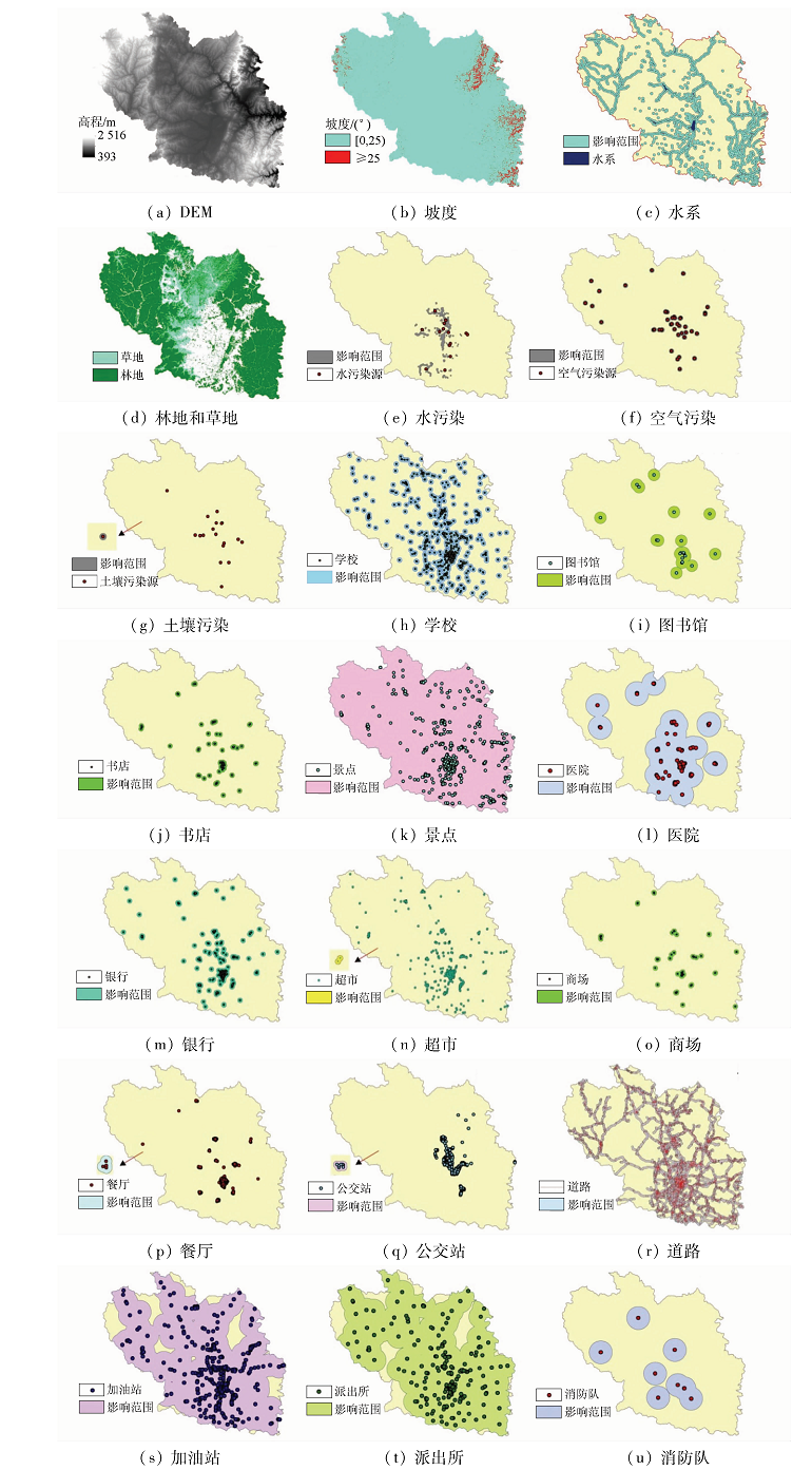
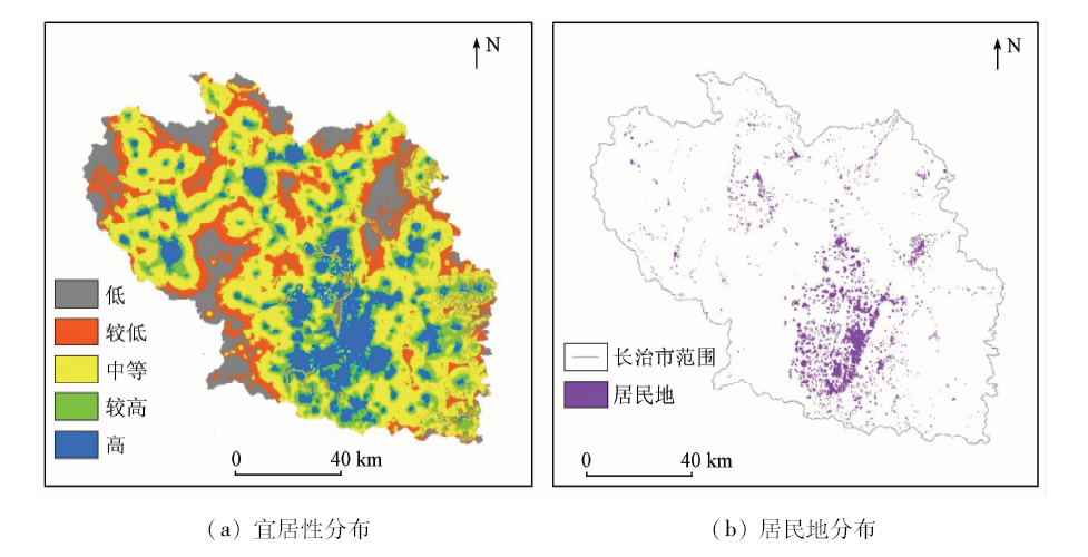
Abstract Residents are the basic living places of human beings, and their livability is significant for human life experience. Based on the two aspects of natural environment and social environment and considering the factors of natural environment, environmental pollution, cultural environment, living convenience and social security, the authors constructed the method of regional livability evaluation. With Changzhi City as the study area, the authors established regional livability evaluation index system using analytic hierarchy process method and calculated the livability index based on Landsat OLI image, DEM, online map POI point and other data in 2018. In addition, the authors classified it by the mean standard deviation method. The livable situation in Changzhi City was analyzed, and the result can provide data support for urban planning management and sustainable development. The results show that the areas with high livability in the study area are mainly concentrated in the south-central as well as western and northwestern of central, whereas the areas with lower livability are concentrated in the northwest, southwest and northeast. There are more high-living areas and higher livable areas in Luzhou District and Shangdang District, and more moderately livable areas in other districts and counties.
|
| Keywords
multi-source data
livability
analytic hierarchy process
mean standard deviation method
|
|
|
|
Corresponding Authors:
GUO Qiaozhen
E-mail: sangxiao1993@126.com;gqiaozhen@tcu.edu.cn
|
|
Issue Date: 09 October 2020
|
|
|
| [1] |
Li X, Li W, Middel A, et al. Remote sensing of the surface urban heat island and land architecture in Phoenix,Arizona:Combined effects of land composition and configuration and cadastral-demographic-economic factors[J]. Remote Sensing of Environment, 2016,174:233-243.
doi: 10.1016/j.rse.2015.12.022
url: https://linkinghub.elsevier.com/retrieve/pii/S0034425715302431
|
| [2] |
Tang X, Shu Y, Lian Y, et al. A spatial assessment of urban waterlogging risk based on a weighted naive Bayes classifier[J]. Science of the Total Environment, 2018,630:264-274.
doi: 10.1016/j.scitotenv.2018.02.172
pmid: 29477824
url: https://www.ncbi.nlm.nih.gov/pubmed/29477824
|
| [3] |
Asadi H, Moghaddam R T, Pour, N S, et al. A new nondominated sorting genetic algorithm based on the regression line for fuzzy traffic signal optimization problem[J]. Scientia Iranica, 2018,25:1712-1723.
|
| [4] |
Shi C, Yuan R, Wu B, et al. Meteorological conditions conducive to PM2.5 pollution in winter 2016/2017 in the western Yangtze River Delta,China[J]. Science of the Total Environment, 2018,642:1221-1232.
pmid: 30045503
url: https://www.ncbi.nlm.nih.gov/pubmed/30045503
|
| [5] |
Ronkko T J, Jalava P I, Happo M S, et al. Emissions and atmospheric processes influence the chemical composition and toxicological properties of urban air particulate matter in Nanjing,China[J]. Science of the Total Environment, 2018,639:1290-1310.
pmid: 29929296
url: https://www.ncbi.nlm.nih.gov/pubmed/29929296
|
| [6] |
Shank K S H, Cutchin M P. Processes of developing community livability in older age[J]. Journal of Aging Studies, 2016,39:66-72.
doi: 10.1016/j.jaging.2016.11.001
pmid: 27912856
url: https://www.ncbi.nlm.nih.gov/pubmed/27912856
|
| [7] |
Leach J M, Lee S E, Boyko C T, et al. Dataset of the livability performance of the city of Birmingham,UK,as measured by its citizen wellbeing,resource security,resource efficiency and carbon emissions[J]. Data in Brief, 2017,15:691-695.
pmid: 29124092
url: https://www.ncbi.nlm.nih.gov/pubmed/29124092
|
| [8] |
Ghasemi K, Hamzenejad M, Meshkini A. The spatial analysis of the livability of 22 districts of Tehran Metropolis using multi-criteria decision making approaches[J]. Sustainble Cities and Society, 2018,38:382-404.
|
| [9] |
江慧娟. 基于多源时空数据的城市社区宜居性动态评价方法研究[D]. 武汉:武汉大学, 2017.
|
| [9] |
Jiang H J. Research on dynamic evaluation method of urban community livability based on multi temporal spatial data[D]. Wuhan:Wuhan University, 2017
|
| [10] |
聂春霞, 孙慧, 唐飞. 中国30个主要城市的宜居性及其差异[J]. 山西财经大学学报, 2012,34(11):11-20.
|
| [10] |
Nei C X, Sun H, Tang F. Livability and differences of 30 Chinese major cities[J]. Journal of Shanxi Finance and Economics University, 2012,34(11):11-20.
|
| [11] |
尹志强. 江苏省城市宜居性评价与宜居城市建设研究[D]. 南京:南京师范大学, 2017.
|
| [11] |
Yin Z Q. Study on the evaluation of urban habitability and the construction of livable city in Jiangsu Province[D]. Nanjing:Nanjing Normal University, 2017.
|
| [12] |
谌丽, 张文忠, 李业锦. 大连居民的城市宜居性评价[J]. 地理学报, 2008,63(10):1022-1032.
doi: 10.11821/xb200810002
url: http://www.geog.com.cn/CN/abstract/abstract21671.shtml
|
| [12] |
Shen L, Zhang W Z, Li Y J. Urban residential suitability evaluation of Dalian’s residents[J]. Acta Geographica Sinica, 2008,63(10):1022-1032.
doi: 10.11821/xb200810002
url: http://www.geog.com.cn/CN/abstract/abstract21671.shtml
|
| [13] |
杨可明. 遥感原理与应用[M]. 北京: 中国矿业大学出版社, 2016.
|
| [13] |
Yang K M. Remote sensing principle and applications[M]. Beijing: China University of Mining and Technology Press, 2016.
|
| [14] |
张文忠. 中国宜居城市研究报告[R].北京: 社会科学文献出版社, 2006.
|
| [14] |
Zhang W Z. A study of livable cities in China[R]. Beijing: Social Science Academic Press China), 2006.
|
| [15] |
俞孔坚. 城市公共空间设计:呼唤人性场所[J].城市环境艺术, 2007(5):25-27.
|
| [15] |
Yu K J. Urban public space design:Calling for human places[J].Urban Environmental Art 2007(5):25-27.
|
| [16] |
楚存坤, 孙思琴, 韩风谈. 基于层次分析法的高校图书馆学科服务评价模式[J]. 大学图书馆学报, 2014,32(6):86-90.
|
| [16] |
Chu C K, Sun S Q, Han F T. Subject service evaluation model study in university library based on AHP[J]. Journal of Academic Libraries, 2014,32(6):86-90.
|
| [17] |
崔凤琪, 唐海萍, 张钦. 京津冀地区城市宜居性评价及影响分析:基于2010—2016年面板数据的实证研究[J]. 北京师范大学学报(自然科学版), 2018,54(5):666-673.
|
| [17] |
Cui F Q, Tang H P, Zhang Q. Urban livability and influencing factors in Beijing,Tianjin,and Hebei:An empirical study based on panel data from 2010—2016[J]. Journal of Beijing Normal University (Natural Science), 2018,54(5):666-673.
|
| [18] |
熊善高, 万军, 龙花楼, 等. 重点生态功能区生态系统服务价值时空变化特征与启示——以湖北省宜昌市为例[J]. 水土保持研究, 2016,23(1):296-302.
|
| [18] |
Xiong S G, Wan J, Long H L, et al. Spatiotemporal dynamics and implications of ecosystem service value in the key ecological function area:Case of Yichang City,Hubei Province[J]. Research of Soil and Water Conservation, 2016,23(1):296-302.
|
| [19] |
卞恒磊. 浅析化工企业生产与污染治理的重要性[J]. 智能城市, 2019,5(3):69-70.
|
| [19] |
Bian H L. Analysis on the importance of chemical enterprise production and pollution control[J]. Intelligent City, 2019,5(3):69-70.
|
| [20] |
李嘉菲, 李雪铭. 城市宜居性居民满意度评价——以大连市为例[J]. 云南地理环境研究, 2008,20(4):77-83.
|
| [20] |
Li J F, Li X M. Evaluation of resident satisfaction about livable city:Taking Dalian as an Example[J]. Yunnan Geographic Environment Research, 2008,20(4):77-83.
|
| [21] |
张志斌, 巨继龙, 陈志杰. 兰州城市宜居性评价及其空间特征[J]. 生态学报, 2014,34(21):6379-6389.
doi: 10.5846/stxb201312313074
url: http://www.ecologica.cn/stxb/ch/reader/view_abstract.aspx?file_no=stxb201312313074&flag=1
|
| [21] |
Zhang Z B, Ju J L, Chen Z J. The livable evaluation and analysis of characteristics of space in Lanzhou[J]. Acta Ecologica Sinica, 2014,34(21):6379-6389.
|
| [22] |
党云晓, 周亚明. 基于居民幸福感视角理解宜居城市[J]. 国际城市规划, 2016,31(5):14-19.
|
| [22] |
Dang Y X, Zhou Y M. Understanding livable city based on the perspective of resident’s happiness[J]. Urban Planning International, 2016,31(5):14-19.
doi: 10.22217/upi
url: http://www.upi-planning.org/
|
| [23] |
Tobler W R. A Computer movie simulating urban growth in the detroit region[J]. Economic Geography, 1970,46(s1):234-240.
doi: 10.2307/143141
url: https://www.jstor.org/stable/143141?origin=crossref
|
| [24] |
付盈, 国巧真, 吴晓旭. 基于Landsat8遥感数据的天津市地表温度反演[J]. 中国环境监测, 2018,34(5):165-172.
|
| [24] |
Fu Y, Guo Q Z, Wu X X. Land surface temperature inversion in Tianjin City based on Landsat8 remote sensing data[J]. Environmental Monitoring in China, 2018,34(5):165-172.
|
|
Viewed |
|
|
|
Full text
|
|
|
|
|
Abstract
|
|
|
|
|
Cited |
|
|
|
|
| |
Shared |
|
|
|
|
| |
Discussed |
|
|
|
|
 2020,
Vol. 32
2020,
Vol. 32
 ), GUO Qiaozhen(