|
|
 |
|

|
|
|
Land use change detection based on multi-source data |
| Zhan ZHAO, Wang XIA, Li YAN |
| School of Geodesy and Geomatics, Wuhan University, Wuhan 430079, China |
|
|
|
|
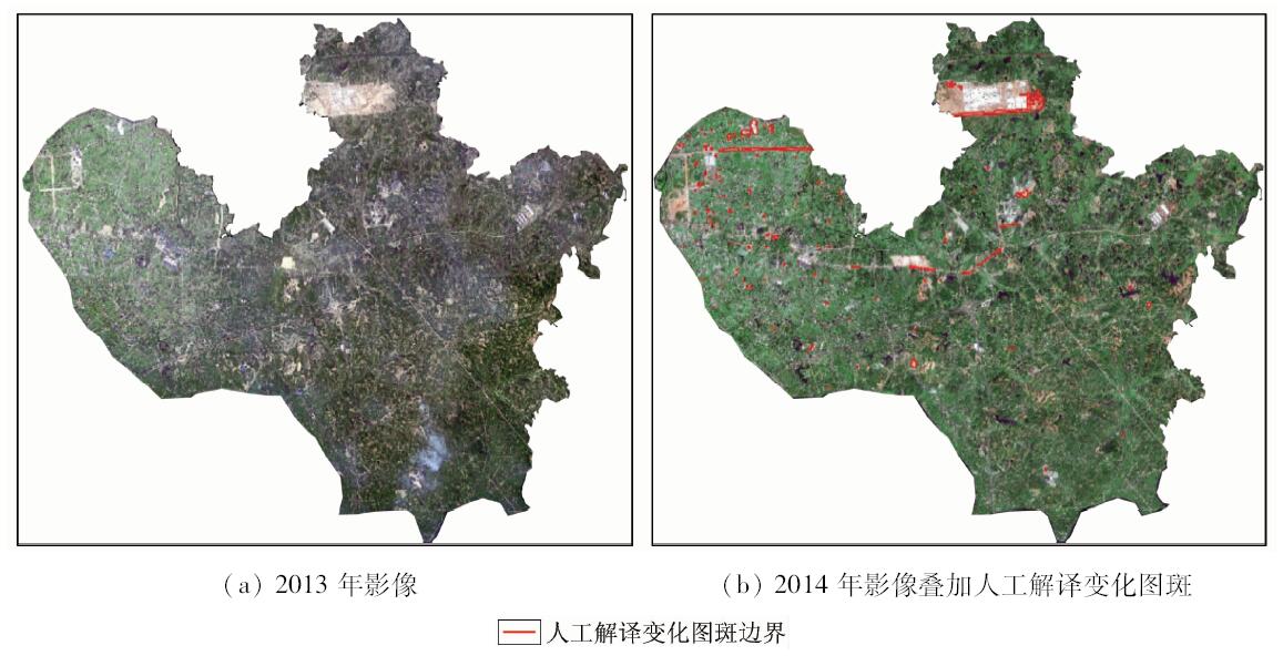
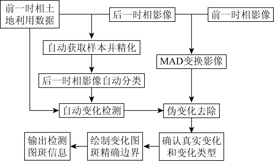
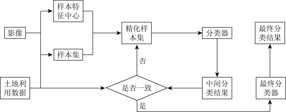
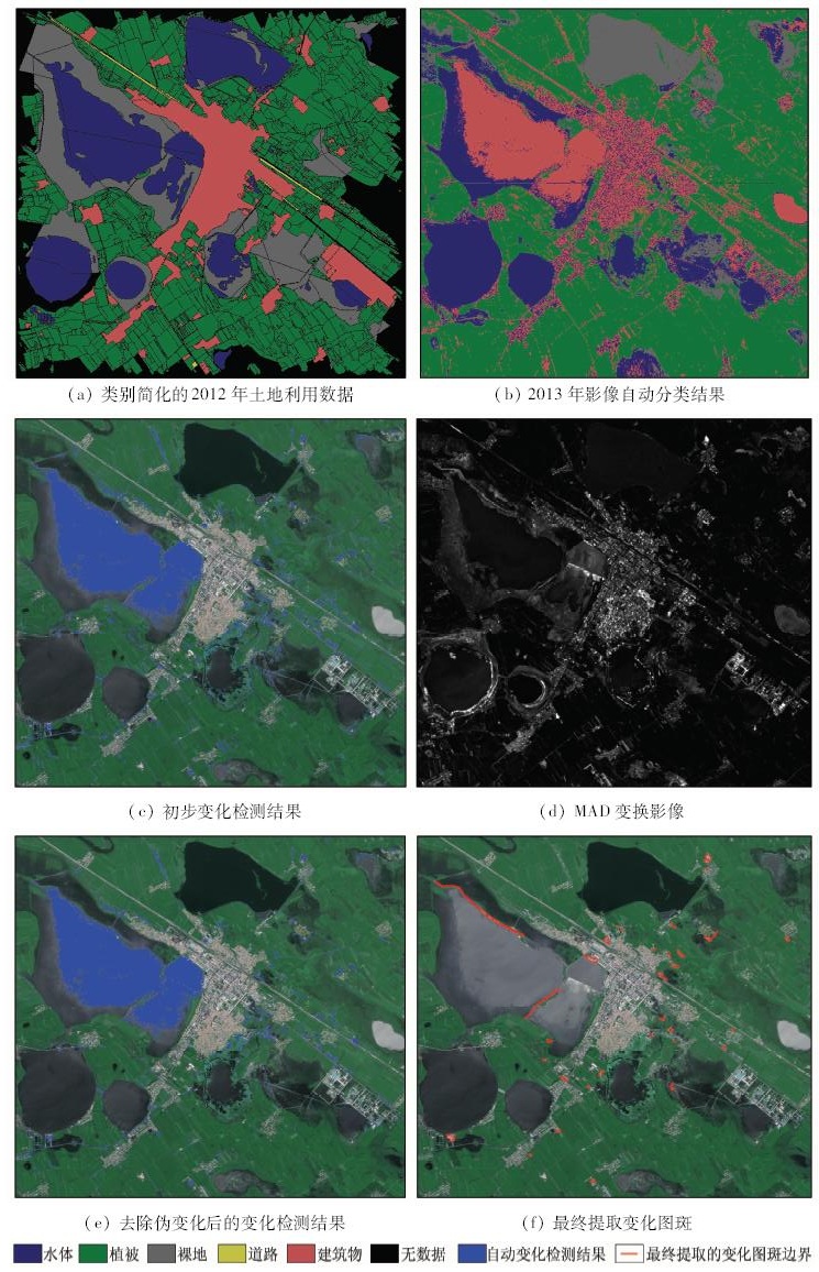
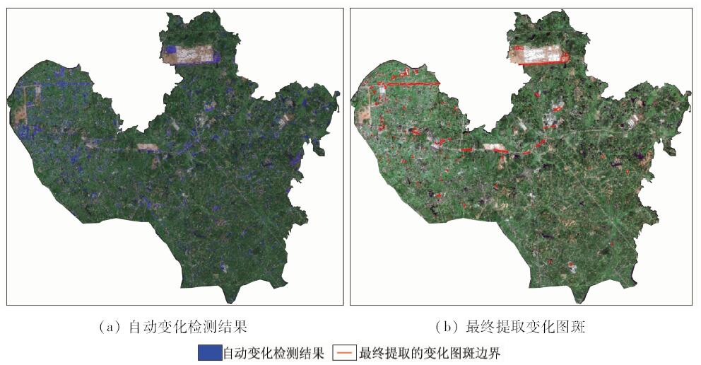
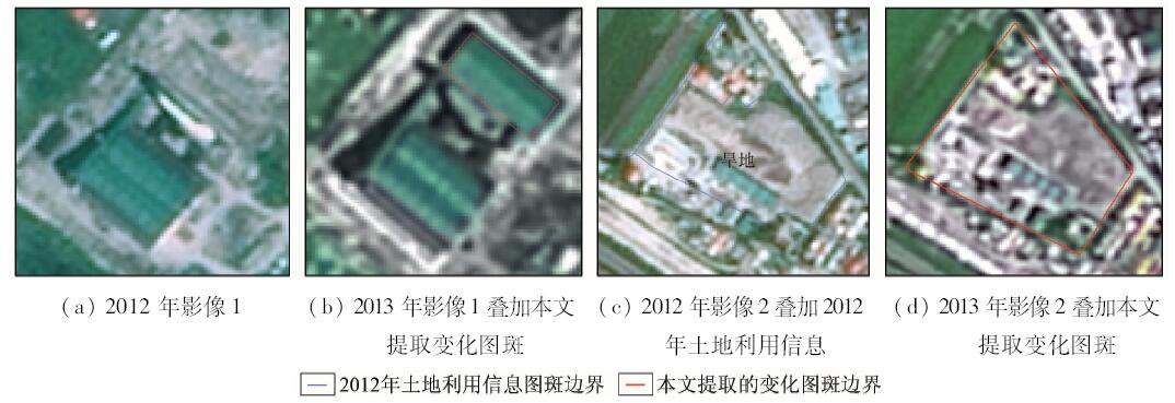
Abstract Annual land use change survey is very important for keeping the land use data of China up-to-date. Currently, Land use change information acquisition is mainly based on artificial visual interpretation, which is low in efficiency. A new method of land use change detection based on multi-source data is presented in this paper. Classification samples for current phase image are acquired form previous phase land use vector data through a processing of sample refining. So automatic classification for current phase image can be implemented, which makes automatic change detected by comparing classification result with previous phase land use. The multivariate alteration detection (MAD) transformation method for the two phase image is used to eliminate pseudo change. The changed polygon objects with accuracy boundary are extracted based on change detect. Experiment shows that the proposed method is more effective with working time less than half that of the traditional method, and can better find real land use change without omission.
|
| Keywords
change detection
land use
multi-source data
|
|
|
|
Issue Date: 07 December 2018
|
|
|
| [1] |
Radke R J, Andra S , AlKofahi O,et al.Image change detection algorithms:A systematic survey[J]. IEEE Transactions on Image Processing:A Publication of the IEEE Signal Processing Society, 2005,14(3):294-307.
doi: 10.1109/TIP.2004.838698
pmid: 15762326
url: http://ieeexplore.ieee.org/document/1395984/
|
| [2] |
Bovolo F, Bruzzone L, Marconcini M . A novel approach to unsupervised change detection based on a semisupervised SVM and a similarity measure[J]. IEEE Transactions on Geoscience and Remote Sensing, 2008,46(7):2070-2082.
doi: 10.1109/TGRS.2008.916643
url: http://ieeexplore.ieee.org/document/4539638/
|
| [3] |
Roy M, Ghosh S, Ghosh A . A novel approach for change detection of remotely sensed images using semi-supervised multiple classifier system[J]. Information Sciences, 2014,269(8):35-47.
doi: 10.1016/j.ins.2014.01.037
url: https://linkinghub.elsevier.com/retrieve/pii/S0020025514000735
|
| [4] |
Nielsen A A . The regularized iteratively reweighted MAD method for change detection in multi-and hyperspectral data[J]. IEEE Transactions on Image Processing:A Publication of the IEEE Signal Processing Society, 2007,16(2):463-478.
doi: 10.1109/TIP.2006.888195
pmid: 17269639
url: http://ieeexplore.ieee.org/document/4060945/
|
| [5] |
Chen J, Lu M, Chen X , et al. A spectral gradient difference based approach for land cover change detection[J]. ISPRS Journal of Photogrammetry and Remote Sensing, 2013,85(2):1-12.
doi: 10.1016/j.isprsjprs.2013.07.009
url: https://linkinghub.elsevier.com/retrieve/pii/S0924271613001792
|
| [6] |
Yuan Y, Lyu H B, Lu X Q . Semi-supervised change detection method for multi-temporal hyperspectral images[J]. Neurocomputing, 2015,148:363-375.
doi: 10.1016/j.neucom.2014.06.024
url: https://linkinghub.elsevier.com/retrieve/pii/S092523121400767X
|
| [7] |
Kleynhans W, Salmon B P, Olivier J C , et al. Land cover change detection using autocorrelation analysis on MODIS time-series data:Detection of new human settlements in the Gauteng Province of South Africa[J]. IEEE Journal of Selected Topics in Applied Earth Observations and Remote Sensing, 2012,5(3):777-783.
doi: 10.1109/JSTARS.2012.2187177
url: http://ieeexplore.ieee.org/document/6171875/
|
| [8] |
Kleynhans W, Salmon B P, Wessels K J , et al. Rapid detection of new and expanding human settlements in the Limpopo Province of South Africa using a spatio-temporal change detection method[J]. International Journal of Applied Earth Observation and Geoinformation, 2015,40:74-80.
doi: 10.1016/j.jag.2015.04.009
url: https://linkinghub.elsevier.com/retrieve/pii/S0303243415000884
|
| [9] |
He C Y, Shi P J, Xie D Y , et al. Improving the normalized difference built-up index to map urban built-up areas using a semiautomatic segmentation approach[J]. Remote Sensing Letters, 2010,1(4):213-221.
doi: 10.1080/01431161.2010.481681
url: http://www.tandfonline.com/doi/abs/10.1080/01431161.2010.481681
|
| [10] |
Huang X, Zhang L P, Zhu T T . Building change detection from multitemporal high-resolution remotely sensed images based on a morphological building index[J]. IEEE Journal of Selected Topics in Applied Earth Observations and Remote Sensing, 2014,7(1):105-115.
doi: 10.1109/JSTARS.2013.2252423
url: http://ieeexplore.ieee.org/document/6509456/
|
| [11] |
Varshney A . Improved NDBI differencing algorithm for built-up regions change detection from remote-sensing data:An automated approach[J]. Remote Sensing Letters, 2013,4(5):504-512.
doi: 10.1080/2150704X.2013.763297
url: http://www.tandfonline.com/doi/abs/10.1080/2150704X.2013.763297
|
| [12] |
Melgani F, Moser G, Serpico S B. Unsupervised change-detection methods for remote-sensing images [C]//Serpico SB.Proceedings of the Society of Photo-optical Instrumentation Engineers(SPIE). 2002,4541:211-222.
|
| [13] |
杜培军, 柳思聪 . 融合多特征的遥感影像变化检测[J]. 遥感学报, 2012,16(4):663-677.
|
| [13] |
Du P J, Liu S C . Change detection from multi-temporal remote sensing images by integrating multiple features[J]. Journal of Remote Sensing, 2012,16(4):663-677.
|
| [14] |
Halmy M W A, Gessler P E, Hicke J A , et al. Land use/land cover change detection and prediction in the north-western coastal desert of Egypt using Markov-CA[J]. Applied Geography, 2015,63:101-112.
doi: 10.1016/j.apgeog.2015.06.015
url: https://linkinghub.elsevier.com/retrieve/pii/S0143622815001599
|
| [15] |
Castellana L , D’Addabbo A,Pasquariello G.A composed supervised/unsupervised approach to improve change detection from remote sensing[J]. Pattern Recognition Letters, 2007,28(4):405-413.
doi: 10.1016/j.patrec.2006.08.010
url: http://linkinghub.elsevier.com/retrieve/pii/S0167865506002200
|
| [16] |
Singh P, Kato Z, Zerubia J. A multilayer markovian model for change detection in aerial image pairs with large time differences [C]// IEEE.2014 22nd International Conference on Pattern Recognition (ICPR).Stockholm, 2014: 924-929.
|
| [17] |
Benedek C, Szirányi T . Change detection in optical aerial images by a multilayer conditional mixed Markov model[J]. IEEE Transactions on Geoscience and Remote Sensing, 2009,47(10):3416-3430.
doi: 10.1109/TGRS.2009.2022633
url: http://ieeexplore.ieee.org/document/5169964/
|
| [18] |
Szirányi T, Shadaydeh M . Segmentation of remote sensing images using similarity-measure-based fusion-MRF model[J]. IEEE Geoscience and Remote Sensing Letters, 2014,11(9):1544-1548.
doi: 10.1109/LGRS.2014.2300873
url: http://ieeexplore.ieee.org/document/6730687/
|
| [19] |
Huang Z, Jia X P . Integrating remotely sensed data,GIS and expert knowledge to update object-based land use/land cover information[J]. International Journal of Remote Sensing, 2012,33(4):905-921.
doi: 10.1080/01431161.2010.536182
url: https://www.tandfonline.com/doi/full/10.1080/01431161.2010.536182
|
| [20] |
Hussain M, Chen D M, Cheng A , et al. Change detection from remotely sensed images:From pixel-based to object-based approaches[J]. ISPRS Journal of Photogrammetry and Remote Sensing, 2013,80:91-106.
doi: 10.1016/j.isprsjprs.2013.03.006
url: https://linkinghub.elsevier.com/retrieve/pii/S0924271613000804
|
| [21] |
张剑清, 佘琼, 潘励 . 基于LBP/C纹理的遥感影像居民地变化检测[J]. 武汉大学学报(信息科学版), 2008,33(1):7-11.
url: http://d.wanfangdata.com.cn/Periodical/whchkjdxxb200801002
|
| [21] |
Zhang J Q, She Q, Pan L . Change detection of residential area by remote sensing image based on LBP/C texture[J]. Geomatics and Information Science of Wuhan University, 2008,33(1):7-11.
|
| [22] |
Bouziani M, Goïta K, He D C . Automatic change detection of buildings in urban environment from very high spatial resolution images using existing geodatabase and prior knowledge[J]. ISPRS Journal of Photogrammetry and Remote Sensing, 2010,65(1):143-153.
doi: 10.1016/j.isprsjprs.2009.10.002
url: http://linkinghub.elsevier.com/retrieve/pii/S092427160900121X
|
|
Viewed |
|
|
|
Full text
|
|
|
|
|
Abstract
|
|
|
|
|
Cited |
|
|
|
|
| |
Shared |
|
|
|
|
| |
Discussed |
|
|
|
|
 2018,
Vol. 30
2018,
Vol. 30