|
|
 |
|

|
|
|
Remote sensing interpretation and spatial distribution characteristics of the Anhui segment of Tanlu fault zone based on multi-source data |
| Weidong ZHAO1,2,3, Yong ZHENG1, Haonan ZHANG1,2, Qiong JIANG3, Jiajia WEI1,2 |
1. School of Resource and Environmental Engineering, Hefei University of Technology, Hefei 230009, China
2. Intelligent Manufacturing Technology Institute, Hefei University of Technology, Hefei 230088, China
3. School of Civil and Hydraulic Engineering, Hefei University of Technology, Hefei 230009, China |
|
|
|
|
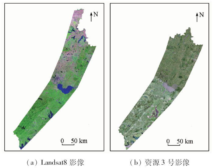
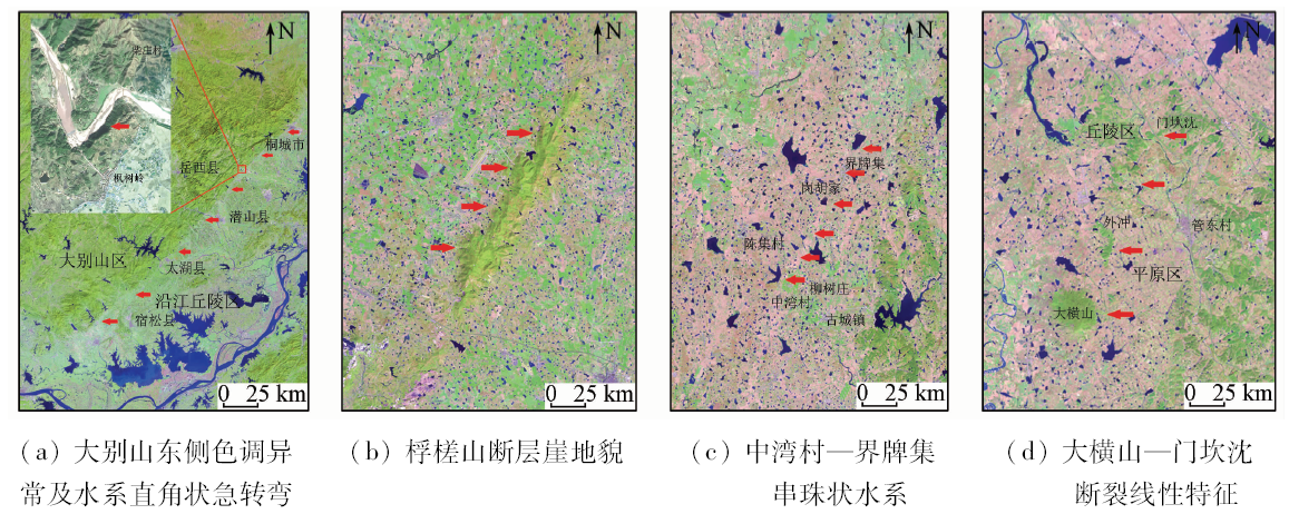
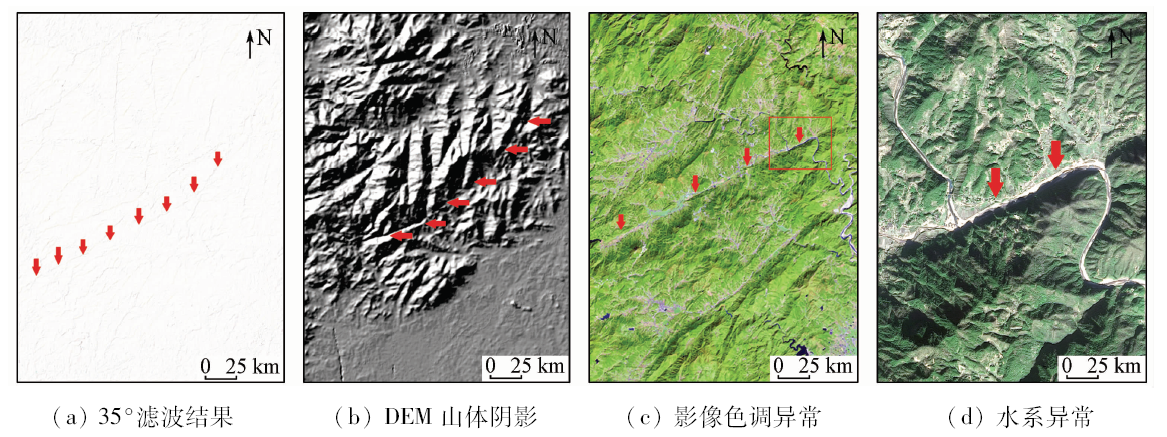
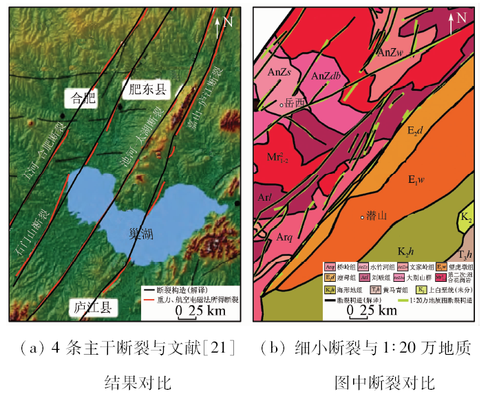
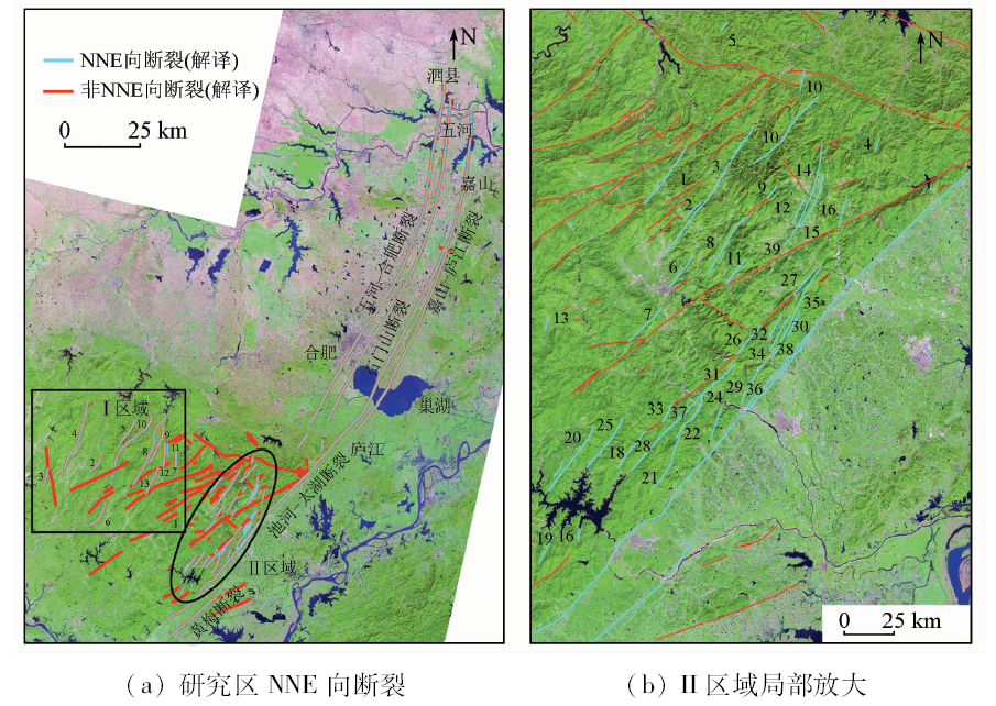
Abstract In the previous study of the Anhui segment of Tanlu fault zone, it is generally believed that the Anhui segment of Tanlu fault zone is composed of the Wuhe-Hefei fault, the Shimenshan fault, the Chihe-Taihu fault and the Jiashan-Lujiang fault. However, there is no comprehensive and systematic research on the exact boundary position of the fault zone, especially the boundary of the Dabie Mountain in the southern part of the Anhui segment of the Tanlu fault zone. In view of such a situation, based on the multi-source data such as Landsat 8 OLI, ZY-3 and DEM data, the authors comprehensively utilized GIS spatial analysis and spatial statistics to perform remote sensing interpretation of the Anhui segment of Tanlu fault zone and statistical analysis of the interpretation results. The analysis shows the more accurate boundary range of the Anhui segment of Tanlu fault zone. The existing geological data prove that the boundary range is reasonable and reliable to some extent. The study shows that the spatial distribution characteristics of the north and south sections of the Anhui segment of Tanlu fault zone are different. The average trend of the northern section is about N23.5°E, the average width is about 25.99 km, the average trend of the southern section is about N34.9°E, and the average width is about 38.38 km, the overall trend of the whole Anhui segment of Tanlu fault zone is about N33.3°E, with an average width about 30.35 km. The fault zone presents a spatial distribution pattern of “short in the north and long in the south”, “ wide in the south and narrow in the north” and “the fault trend progressively moving northward from south to north”. The research results can provide an important reference for urban planning, engineering construction and geological disaster prevention within the Anhui segment of Tanlu fault zone.
|
| Keywords
Tanlu fault zone
remote sensing
multi-source data
spatial analysis
|
|
|
|
Issue Date: 03 December 2019
|
|
|
| [1] |
安徽省地质矿产局. 安徽省区域地质志[M]. 北京: 地质出版社, 1987: 501-507.
|
| [1] |
Anhui Provincial Bureau of Geology and Mineral Resources. Regional Geology of Anhui Province[M]. Beijing: Geological Publishing House, 1987: 501-507.
|
| [2] |
张交东, 杨长春, 刘成斋 , 等. 郊庐断裂南段走滑和伸展断裂的深部结构及位置关系[J]. 地球物理学报, 2010,53(4):864-873.
doi: 10.3969/j.issn.0001-5733.2010.04.011
|
| [2] |
Zhang J D, Yang C C, Liu C Z , et al. The deep structures of strike-slip and extension faults and their composite relationship in the southern segment of Tanlu fault zone[J]. Chinese Journal of Geophysics, 2010,53(4):864-873.
|
| [3] |
Xu J W, Zhu G, Tong W X , et al. Formation and evolution of the Tancheng-Lujiang wrench fault system:A major shear system to the northern of the Pacific Ocean[J]. Tectonophysics, 1987,134(4):273-310.
|
| [4] |
Xu J W, Zhu G . Tectonic models of the Tan-Lu fault zone,eastern China[J]. International Geology Review, 1994,36(8):771-784.
|
| [5] |
国家地震局地质研究所. 郯庐断裂[M]. 北京: 地震出版社, 1987.
|
| [5] |
Institute of Geology State Seismological Bureau. Tanlu Fault[M]. Beijing: Seismological Press, 1987.
|
| [6] |
徐嘉炜, 马国锋 . 郯庐断裂带研究的十年回顾[J]. 地质论评, 1992,38(4):316-324.
|
| [6] |
Xu J W, Ma G F . Review of the years (1981—1991) of research on the Tancheng-Lujiang fault zone[J]. Geological Review, 1992,38(4):316-324.
|
| [7] |
魏光兴, 刁守中, 周翠英 . 郯庐带地震活动性研究[M]. 北京: 地震出版社, 1993.
|
| [7] |
Wei G X, Diao S Z, Zhou C Y. Study of Seismicity Along the Tancheng-Lujiang Seismic Zone[M]. Beijing: Seismological Press, 1993.
|
| [8] |
赵田, 朱光, 林少泽 , 等. 郯庐断裂带张八岭隆起段变质岩的原岩时代与变形机制[J]. 中国科学(地球科学), 2014,44(10):2112-2129.
|
| [8] |
Zhao T, Zhu G, Lin S Z , et al. Protolith ages and deformation mechanism of metamorphic rocks in the Zhangbaling uplift segment of the Tan-Lu fault zone[J]. Science China(Earth Sciences), 2014,44(10):2112-2129.
|
| [9] |
汤家富, 李怀坤, 娄清 . 郯庐断裂南段研究进展与断裂性质讨论[J]. 地质通报, 2003,22(6):426-436.
|
| [9] |
Tang J F, Li H K, Lou Q . Progress in the study of the southern segment of the Tanlu fault and a discussion of the nature of the fault[J]. Geological Bulletin of China, 2003,22(6):426-436.
|
| [10] |
李云平, 吴时国, 韩文功 , 等. 合肥盆地和郯庐断裂带南段深部地球物理特征研究[J]. 地球物理学报, 2006,49(1):115-122.
|
| [10] |
Li Y P, Wu S G, Han W G , et al. A study on geophysical features of deep structures of the Hefei Basin and the southern Tan-Lu fault zone[J]. Chinese Journal of Geophysics, 2006,49(1):115-122.
|
| [11] |
聂峰, 石永红, 张忠宝 , 等. 安徽北部郯庐断裂两侧基底岩石年龄及对郯庐断裂初始开启时间的限定[J]. 科学通报, 2015,60(24):2315-2326.
|
| [11] |
Nie F, Shi Y H, Zhang Z B , et al. The initial time of the Tan-Lu wrench fault:In the view of geochronological data of the basement rocks,northern Anhui Province[J]. Chinese Science Bulletin, 2015,60(24):2315-2326.
|
| [12] |
芮柏 . 对苏皖断裂带的初步研究(郯—庐断裂研究之二)[J]. 华东地质学院学报, 1988,11(1):1-10.
|
| [12] |
Rui B . The preliminary study on the Su-Wan fault zone (two that studied Tan Lu fault zone)[J]. Journal of East China College of Geology, 1988,11(1):1-10.
|
| [13] |
宋传中, 王国强, 朱光 , 等. 郯庐断裂带桐城—庐江段的构造特征及演化[J]. 安徽地质, 1998,8(4):37-40.
|
| [13] |
Song C Z, Wang G Q, Zhu G , et al. Structural characteristics and evolution of the Tongcheng to Lujiang section of the Tan Lu fault zone[J]. Geology of Anhui, 1998,8(4):37-40.
|
| [14] |
王小凤 . 郯庐断裂带[M]. 北京: 地质出版社, 2000.
|
| [14] |
Wang X F. Tan-Lu Fault Zone[M]. Beijing: Geological Publishing House, 2000.
|
| [15] |
徐嘉炜 . 徐嘉炜论郯庐断裂带(论文选集)[M]. 合肥: 合肥工业大学出版社, 2015.
|
| [15] |
Xu J W. Xu Jiawei on Tan Lu Fault Zone(Selected Papers)[M]. Hefei: Hefei University of Technology Press, 2015.
|
| [16] |
侯明金, 王永敏, Mercier J , 等. 郯庐断裂带(安徽部分)动力学演化及其构造意义[J]. 地质通报, 2003,22(2):105-112.
|
| [16] |
Hou M J, Wang Y M, Mercier J , et al. Dynamic of the evolution and tectonic significance Tanlu fault zone(Anhui segment)[J]. Geological Bulletin of China, 2003,22(2):105-112.
|
| [17] |
赵英时 . 遥感应用分析原理与方法[M]. 北京: 科学出版社, 2003.
|
| [17] |
Zhao Y S. Principles and Methods of Remote Sensing Application Analysis[M]. Beijing: Science Press, 2003.
|
| [18] |
齐信, 邵长生, 陈州丰 , 等. 多源遥感数据在断裂构造解译中的应用[J]. 大地测量与地球动力学, 2012,32(4):90-93.
|
| [18] |
Qi X, Shao C S, Chen Z F , et al. Application of Multi-source remote sensing date in fault structure interretation[J]. Journal of Geo-desy and Geodynamics, 2012,32(4):90-93.
|
| [19] |
Sabins F F . Remote Sensing:Principles and Interpretation[M]. New York:W.H.Freeman and Company, 1997.
|
| [20] |
杨韫澜, 韩玲, 韩晓勇 , 等. 基于资源三号和ETM+影像的断裂构造解译[J]. 地理空间信息, 2014,12(5):17-19.
|
| [20] |
Yang Y L, Han L, Han X Y , et al. Fracture structure interpretation based on ZY-3 and ETM+[J]. Geospatial Information, 2014,12(5):17-19.
|
| [21] |
王鑫, 张景发, 姜文亮 , 等. 郯庐断裂带南段重力异常及不同深度的横向构造特征[J]. 地震地质, 2016,38(2):370-385.
doi: 10.3969/j.issn.0253-4967.2016.02.011
|
| [21] |
Wang X, Zhang J F, Jiang W L , et al. Transverse structures features of different depths derived from bouguer gravity anomalies in the southern segment of Tan-Lu fault zone[J]. Seismology and Geolo-gy, 2016,38(2):370-385.
|
| [22] |
姚大全, 汤有标, 刘加灿 , 等. 大别山东北部基岩区断裂活动习性的综合研究[J]. 地震地质, 1999,21(1):63-68.
|
| [22] |
Yao D Q, Tang Y B, Liu J C , et al. A synthetical study on active behavior of fault in bedrock area of northeastern Dabie Mountain[J]. Seismology and Geology, 1999,21(1):63-68.
|
| [23] |
张交东, 刘德良, 林会喜 , 等. 郯庐断裂带南段巨型正花状构造的发现及地质意义[J]. 中国科学技术大学学报, 2003,33(4):486-490.
|
| [23] |
Zhang J D, Liu D L, Lin H X , et al. Discovery of the giant positive-flower-structure in the southern part of Tanlu fault and it’s geological significance[J]. Journal of University of Science and Technology of China, 2003,33(4):486-490.
|
|
Viewed |
|
|
|
Full text
|
|
|
|
|
Abstract
|
|
|
|
|
Cited |
|
|
|
|
| |
Shared |
|
|
|
|
| |
Discussed |
|
|
|
|
 2019,
Vol. 31
2019,
Vol. 31