|
|
|
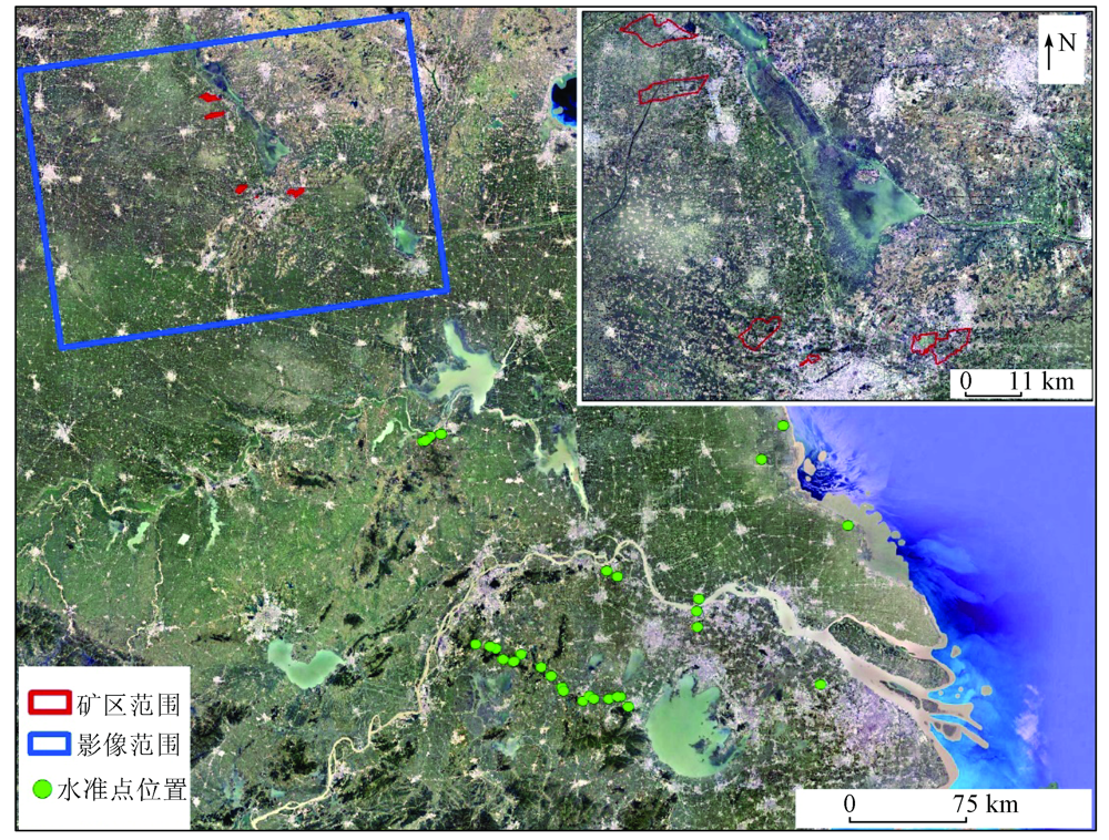
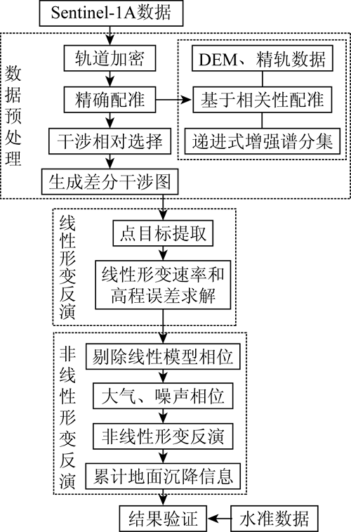
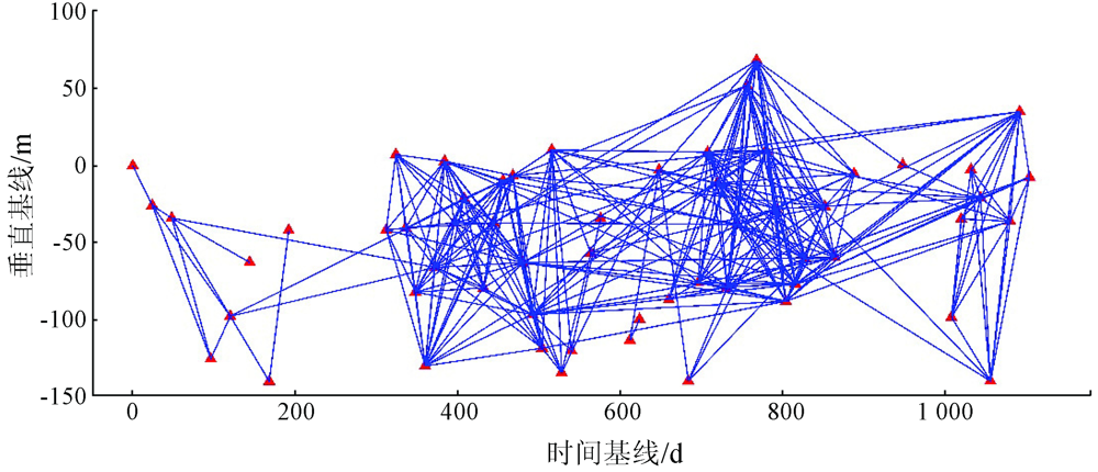
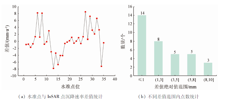
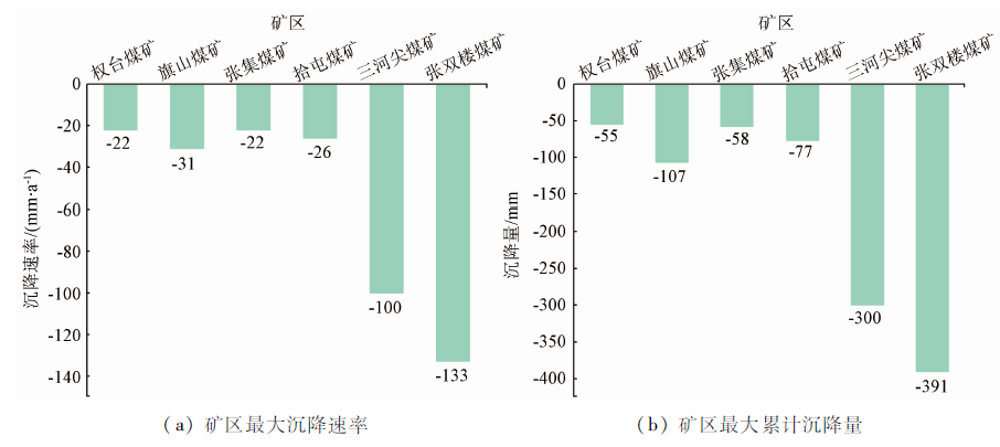
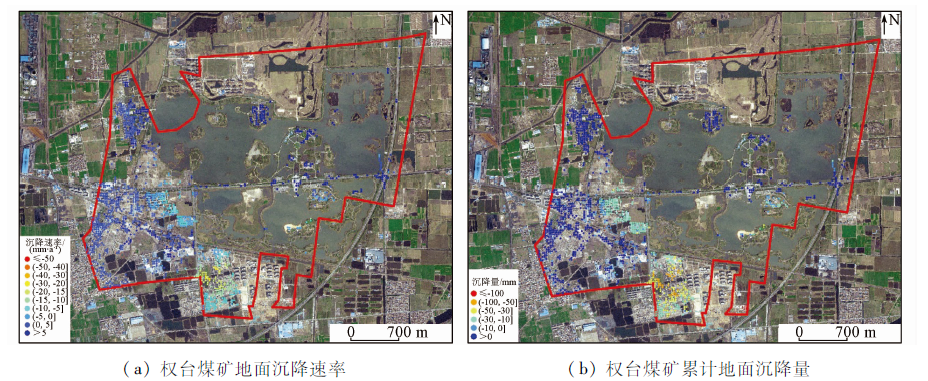
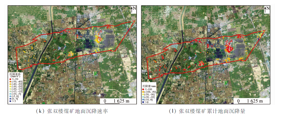
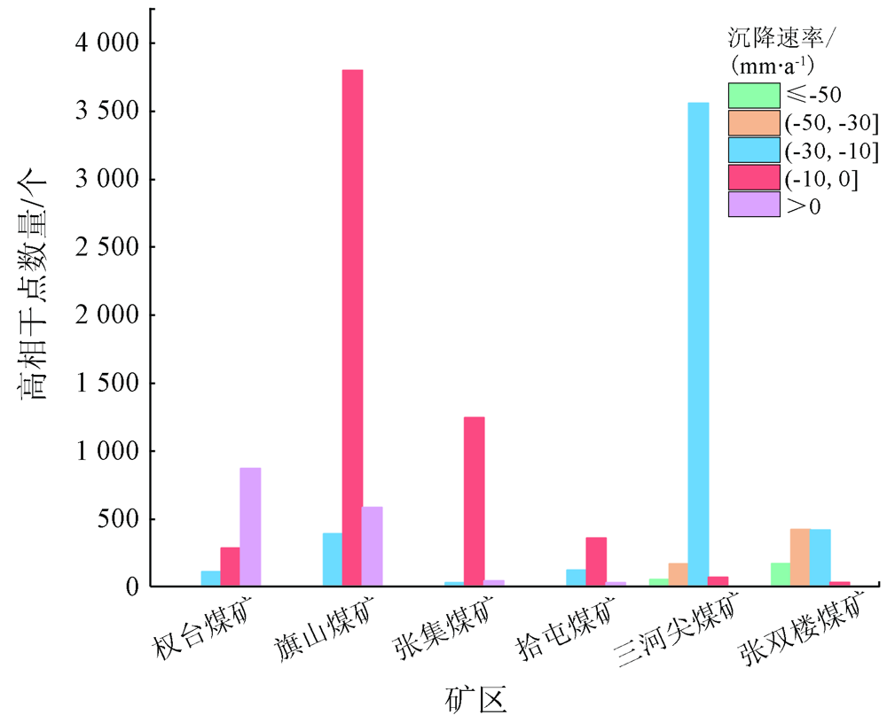
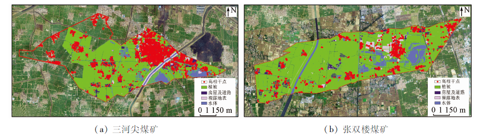
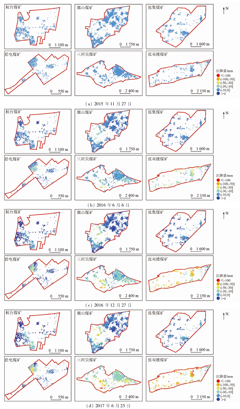
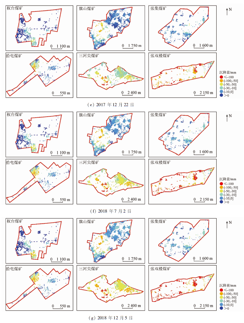
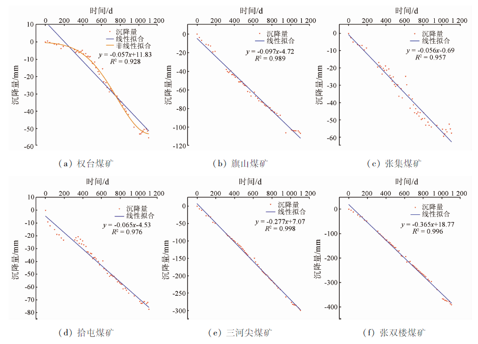
Abstract The time-series interferometric synthetic aperture Radar (InSAR) technology has been widely used since it allows for the safe and efficient obtainment of large-scale high-precision ground subsidence data. It is still a hot topic to efficiently obtain accurate land subsidence data of mining areas at different mining states using this technology to provide data support for the ecological governance of the mining areas. Based on Sentinel-1A images (58 scenes per complete orbit), this paper conducts time series monitoring of six mining areas in Xuzhou City using the multiple master-image coherent target small-baseline interferometric SAR (MCTSB-InSAR) technique and obtains land subsidence results during 2016—2018. Meanwhile, it verifies the accuracy of the obtained subsidence rate using the measured data in a similar period, yielding a difference in root mean square error of 4.0 mm/a. Therefore, the monitoring requirements can be satisfied. The monitoring results are as follows. The Zhangshuanglou and Sanhejian coal mines suffered serious land subsidence, with the maximum average annual subsidence rate exceeding 100 mm/a and the maximum cumulative subsidence exceeding 300 mm. In comparison, the Qishan, Shitun, Quantai, and Zhangji coal mines experienced light subsidence, which all occurred within the mining areas and did not show a notable expansion trend during the monitoring period. Based on these results and the monitoring data of the basic geographical state of Jiangsu Province in 2016, there were 2 844 and 672 high-coherence points falling in houses and roads, respectively for the Sanhejian and Zhangshuanglou coal mines, which accounted for 73.66% and 63.33% of the total high coherence points of the mines, respectively. For the mining areas except for the Quantai coal mine, there was a roughly linear relationship between the subsidence amount and time, which was stronger in the mines under mining than in the mines where mining had stopped. In contrast, the relationship between the subsidence amount in the Quantai coal mine and time presented a nonlinear law. The experiment results show that Sentinel-1A images and the MCTSB-InSAR technique have good application prospects in the monitoring and analysis of land subsidence in mining areas.
|
| Keywords
mining area
subsidence monitoring
time-series analysis
InSAR technique
|
|
|
|
Issue Date: 23 December 2021
|
|
|
| [1] |
Howladar M F. Environmental impacts of subsidence around the Barapukuria coal mining area in Bangladesh[J]. Energy,Ecology and Environment, 2016,1(6):370-385.
doi: 10.1007/s40974-016-0031-x
url: http://link.springer.com/10.1007/s40974-016-0031-x
|
| [2] |
Sahu P, Lokhande R D. An investigation of sinkhole subsidence and its preventive measures in underground coal mining[J]. Procedia Earth and Planetary Science, 2015,11:63-75.
doi: 10.1016/j.proeps.2015.06.009
url: https://linkinghub.elsevier.com/retrieve/pii/S1878522015000600
|
| [3] |
Saeidi A, Deck O, Verdel T. Comparison of building damage assessment methods for risk analysis in mining subsidence regions[J]. Geotechnical and Geological Engineering, 2013,31(4):1073-1088.
doi: 10.1007/s10706-013-9633-7
url: http://link.springer.com/10.1007/s10706-013-9633-7
|
| [4] |
岳建平, 方露. 城市地面沉降监控理论与技术[M]. 北京: 科学出版社, 2012:1-5.
|
| [4] |
Yue J P, Fang L. Theory and technology of urban land subsidence monitoring[M]. Beijing: Science Press, 2012:1-5.
|
| [5] |
Liu X, Wang Y, Yan S. Interferometric SAR time series analysis for ground subsidence of the abandoned mining area in north Peixian using Sentinel-1A TOPS data[J]. Journal of the Indian Society of Remote Sensing, 2018,46(3):451-461.
doi: 10.1007/s12524-017-0708-4
url: http://link.springer.com/10.1007/s12524-017-0708-4
|
| [6] |
何敏, 陆晓燕, 何秀凤. 利用D-InSAR二轨法监测徐州大屯中心区地表形变[J]. 地理空间信息, 2011,9(5):3-5.
|
| [6] |
He M, Lu X Y, He X F. Surface deformation in the central area of Xuzhou Datun was monitored by D-InSAR[J]. Geospatial Information, 2011,9(5):3-5.
|
| [7] |
郭炳跃, 何敏, 刘建东. 利用InSAR技术监测徐州市矿区地表变形[J]. 地质学刊, 2012,36(1):99-103.
|
| [7] |
Guo B Y, He M, Liu J D. Surface deformation monitoring with InSAR technology in Xuzhou[J]. Journal of Geology, 2012,36(1):99-103.
|
| [8] |
武继峰, 杨志强. InSAR技术应用于矿区开采沉陷监测的数据优选研究[J]. 测绘通报, 2013(s1):92-94.
|
| [8] |
Wu J F, Yang Z Q. The study of the data optimization of mining subsidence monitoring based on InSAR technique[J]. Bulletin of Surveying and Mapping, 2013(s1):92-94.
|
| [9] |
Yang C, Zhang D, Zhao C, et al. Ground deformation revealed by Sentinel-1 MSBAS-InSAR time-series over Karamay oilfield,China[J]. Remote Sensing, 2019,11(17):2027.
doi: 10.3390/rs11172027
url: https://www.mdpi.com/2072-4292/11/17/2027
|
| [10] |
Chaussard E, Wdowinski S, Cabral-Cano E, et al. Land subsidence in central Mexico detected by ALOS InSAR time-series[J]. Remote Sensing of Environment, 2014,140:94-106.
doi: 10.1016/j.rse.2013.08.038
url: https://linkinghub.elsevier.com/retrieve/pii/S0034425713002964
|
| [11] |
李达, 邓喀中, 高晓雄, 等. 基于SBAS-InSAR的矿区地表沉降监测与分析[J]. 武汉大学学报(信息科学版), 2018,43(10):1531-1537.
|
| [11] |
Li D, Deng K Z, Gao X X, et al. Monitoring and analysis of surface subsidence in mining area based on SBAS-InSAR[J]. Geomatics and Information Science of Wuhan University, 2018,43(10):1531-1537.
|
| [12] |
Chatterjee R S, Thapa S, Singh K B, et al. Detecting,mapping and monitoring of land subsidence in Jharia Coalfield,Jharkhand,India by spaceborne differential interferometric SAR,GPS and precision levelling techniques[J]. Journal of Earth System Science, 2015,124(6):1359-1376.
doi: 10.1007/s12040-015-0606-5
url: http://link.springer.com/10.1007/s12040-015-0606-5
|
| [13] |
Grzovic M, Ghulam A. Evaluation of land subsidence from underground coal mining using time SAR (SBAS and PSI) in Springfield,Illinois,USA[J]. Natural Hazards, 2015,79(3):1739-1751.
doi: 10.1007/s11069-015-1927-z
url: http://link.springer.com/10.1007/s11069-015-1927-z
|
| [14] |
Bateson L, Cigna F, Boon D, et al. The application of the intermittent SBAS (ISBAS) InSAR method to the South Wales Coalfield,UK[J]. International Journal of Applied Earth Observation and Geoinformation, 2015,34:249-257.
doi: 10.1016/j.jag.2014.08.018
url: https://linkinghub.elsevier.com/retrieve/pii/S0303243414001822
|
| [15] |
Gupta M, Mohanty K K, Kumar D, et al. Monitoring surface elevation changes in Jharia coalfield, India using synthetic aperture Radar interferometry[J]. Environmental Earth Sciences, 2014,71(6):2875-2883.
doi: 10.1007/s12665-013-2664-9
url: http://link.springer.com/10.1007/s12665-013-2664-9
|
| [16] |
陆燕燕, 何敏, 何秀凤. 基于DInSAR的徐州张双楼煤矿地表形变监测研究[J]. 测绘工程, 2013,22(6):61-64.
|
| [16] |
Lu Y Y, He M, He X F. Ground subsidence monitoring of Zhangshuanglou coal mine in Xuzhou City based on DInSAR[J]. Engineering of Surveying and Mapping, 2013,22(6):61-64.
|
| [17] |
Nannini M, Prats-Iraola P, Zan F D, et al. TOPS time series performance assessment with TerraSAR-X data[J]. IEEE Journal of Selected Topics in Applied Earth Observations and Remote Sensing, 2016,9(8):3832-3848.
doi: 10.1109/JSTARS.4609443
url: https://ieeexplore.ieee.org/xpl/RecentIssue.jsp?punumber=4609443
|
| [18] |
吴文豪, 李陶, 龙四春, 等. 实时轨道条件下Sentinel-1卫星影像干涉配准[J]. 武汉大学学报(信息科学版), 2019,44(5):745-750.
|
| [18] |
Wu W H, Li T, Long S C, et al. Coregistration of sentinel-1 TOPS data for interferometric processing using real-time orbit[J]. Geomatics and Information Science of Wuhan University, 2019,44(5):745-750.
|
| [19] |
De Zan F, Prats-Iraola P, Scheiber R. Interferometry with TOPS:Coregistration and azimuth shifts[C]//Berlin:VDE Verlag GmbH, 2014:949-952.
|
| [20] |
康琪. TOPS模式数据InSAR形变监测配准方法[D]. 北京:中国测绘科学研究院, 2019.
|
| [20] |
Kang Q. Registration method of TOPS data for InSAR deformation monitoring[D]. Beijing:Chinese Academy of Surveying and Mapping, 2019.
|
| [21] |
Ferretti A, Prati C, Rocca F. Permanent scatterers in SAR interfero-metry[J]. IEEE Transactions on Geoscience and Remote Sensing, 2001,39(1):8-20.
doi: 10.1109/36.898661
url: http://ieeexplore.ieee.org/document/898661/
|
| [22] |
Mora O, Mallorqui J J, Broquetas A. Linear and nonlinear terrain deformation maps from a reduced set of interferometric SAR images[J]. IEEE Transactions on Geoscience and Remote Sensing, 2003,41(10):2243-2253.
doi: 10.1109/TGRS.2003.814657
url: http://ieeexplore.ieee.org/document/1237386/
|
| [23] |
张永红, 吴宏安, 孙广通. 时间序列InSAR技术中的形变模型研究[J]. 测绘学报, 2012,41(6):864-869.
|
| [23] |
Zhang Y H, Wu H A, Sun G T. Deformation model of time series interferometric SAR techniques[J]. Acta Geodaetica et Cartographica Sinica, 2012,41(6):864-869.
|
| [24] |
张永红, 吴宏安, 康永辉. 京津冀地区1992—2014年三阶段地面沉降InSAR监测[J]. 测绘学报, 2016,45(9):1050-1058.
|
| [24] |
Zhang Y H, Wu H A, Kang Y H. Ground Subsidence over Beijing-Tianjin-Hebei region during three periods of 1992 to 2014 monitored by interferometric SAR[J]. Acta Geodaetica et Cartographica Sinica, 2016,45(9):1050-1058.
|
| [25] |
国家测绘地理信息局. CH/T 6006—2018时间序列InSAR地表形变监测数据处理规范[S]. 北京: 测绘出版社, 2018.
|
| [25] |
National Bureau of Surveying,Mapping and Geographic Information. CH/T 6006—2018 specification of time series InSAR data processing for ground deformation monitoring[S]. Beijing: Surveying and Mapping Press, 2018.
|
|
Viewed |
|
|
|
Full text
|
|
|
|
|
Abstract
|
|
|
|
|
Cited |
|
|
|
|
| |
Shared |
|
|
|
|
| |
Discussed |
|
|
|
|
 2021,
Vol. 33
2021,
Vol. 33
 ), FAN Xueting, CHEN Chao, LI Qiannan, YANG Jin