|
|
|
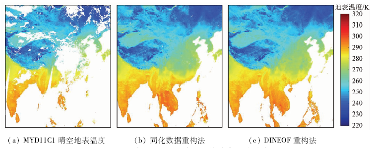
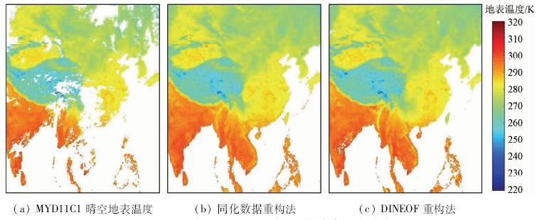
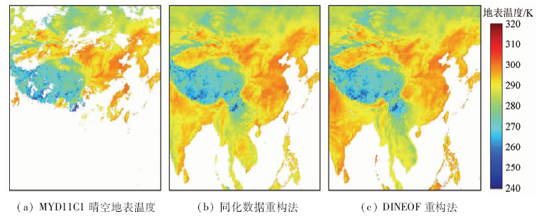
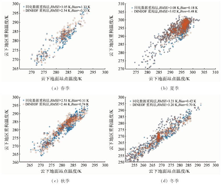
Abstract Land surface temperature is a key parameter in the study of the balance of water and heart between land surface and atmosphere. Obtainment of land surface temperature under all-weather conditions is very important. Although thermal infrared remote sensing technology can retrieve land surface temperature with high spatial resolution and full space coverage in cloud-free sky, the missing data in cloudy sky limit the all-weather applications of land surface temperature in some areas. This study develops two methods for reconstructing missing land surface temperature in cloudy skies. One of the methods is a space-time matched interpolation method helped with dataset of lands surface temperature assimilation. The other method is by data interpolating empirical orthogonal function (DINEOF), which is already popular in reconstruction of sea surface parameters but is rarely used in reconstruction of land surface parameters. The two methods are evaluated by both remotely sensed data and ground measured data in 2017, and the results demonstrate that both of them are adaptable in all seasons and all over China. The accuracies of two methods are very close and located between 2.5 and 3.5 K in cloudy conditions in four seasons in China. This study aims to give some useful references in the study of obtainment of land surface temperature under all-weather conditions.
|
| Keywords
land surface temperature
reconstruction
dataset of lands surface temperature assimilation
DINEOF
|
|
|
|
Corresponding Authors:
TANG Shihao
E-mail: zhoufc@cma.gov.cn;tangsh@cma.gov.cn
|
|
Issue Date: 18 March 2021
|
|
|
| [1] |
陈玲, 黄文婷, 伍静, 等. 广西五圩矿田成矿温度变化及找矿方向分析[J]. 地球化学, 2015,44(6):546-555.
|
| [1] |
Chen L, Huang W T, Wu J, et al. Ore-forming temperature variation and prospecting target of the Wuxu ore field in Guangxi[J]. Geochimica, 2015,44(6):546-555.
|
| [2] |
Voogt J A, Oke T R. Thermal remote sensing of urban climates[J]. Remote Sensing of Environment, 2003,86(3):370-384.
|
| [3] |
李召良, 段四波, 唐伯惠, 等. 热红外地表温度遥感反演方法研究进展[J]. 遥感学报, 2016,20(5):899-920.
|
| [3] |
Li Z L, Duan S B, Tang B H, et al. Review of methods for land surface temperature derived from thermal infrared remotely sensed data[J]. Journal of Remote Sensing, 2016,20(5):899-920.
|
| [4] |
郭晓寅, 程国栋. 遥感技术应用于地表面蒸散发的研究进展[J]. 地球科学进展, 2004,19(1):107-114.
|
| [4] |
Guo X Y, Cheng G D. Advances in the application of remote sensing to evapotranspiration research[J]. Advance in Earth Sciences, 2004,19(1):107-114.
|
| [5] |
张丽华, 陈亚宁, 赵锐锋, 等. 温带荒漠中温度和土壤水分对土壤呼吸的影响[J]. 植物生态学报, 2009,33(5):936-949.
|
| [5] |
Zhang L H, Chen Y N, Zhao R F, et al. Impact of temperature and soil water content on soil respiration in temperate deserts,China[J]. Chinese Journal of Plant Ecology, 2009,33(5):936-949.
|
| [6] |
Arnfield A J. Two decades of urban climate research:A review of turbulence,exchanges of energy and water,and the urban heat island[J]. International Journal of Climatology, 2003,23(1):1-26.
|
| [7] |
Kalma J D, Mcvicar T R, Mccabe M F. Estimating land surface evaporation:A review of methods using remotely sensed surface temperature data[J]. Surveys in Geophysics, 2008,29(4-5):421-469.
|
| [8] |
Kogan F N. Operational space technology for global vegetation assessment[J]. Bulletin of the American Meteorological Society, 2001,82(9):1949-1964.
|
| [9] |
Valor E, Caselles V. Mapping land surface emissivity from NDVI:Application to European,African,and South American areas[J]. Remote Sensing of Environment, 1996,57(3):167-184.
|
| [10] |
Li Z L, Tang B H, Wu H, et al. Satellite-derived land surface temperature:Current status and perspectives[J]. Remote Sensing of Environment, 2013,131(131):14-37.
|
| [11] |
Wan Z, Zhang Y, Zhang Q, et al. Quality assessment and validation of the modis global land surface temperature[J]. International Journal of Remote Sensing, 2004,25(1), 261-274.
|
| [12] |
Duan S B, Li Z L. Spatial downscaling of MODIS land surface temperatures using geographically weighted regression:Case study in northern China[J]. IEEE Transactions on Geoscience and Remote Sensing, 2016,54(11):6458-6469.
|
| [13] |
郭俊如, 宋军, 鲍献文, 等. 东中国海遥感叶绿素数据重构方法研究[J]. 遥感技术与应用, 2016,31(5):939-949.
|
| [13] |
Guo J R, Song J, Bao X W, et al. The method study of remote sensing data reconstruction in multi-scale variations of chlorophyll in east China sea[J]. Remote Sensing Technology and Application, 2016,31(5):939-949.
|
| [14] |
赵冰, 毛克彪, 蔡玉林, 等. 中国地表温度时空演变规律研究[J]. 国土资源遥感, 2020,32(2):233-240.doi: 10.6046/gtzyyg.2020.02.30.
|
| [14] |
Zhao B, Mao K B, Cai Y L, et al. Study of the temporal and spatial evolution law of land surface temperature in China[J]. Remote Sensing for Land and Resources, 2020,32(2):233-240.doi: 10.6046/gtzyyg.2020.02.30.
|
| [15] |
吴迪, 陈健, 石满, 等. 基于Savitzky-Golay滤波算法的FY-2F地表温度产品时间序列重建[J]. 国土资源遥感, 2019,31(2):59-65.doi: 10.6046/gtzyyg.2019.02.09.
|
| [15] |
Wu D, Chen J, Shi M, et al. Reconstruction of land surface temperature time-series datasets of FY-2F based on Savitzky-Golay filter[J]. Remote Sensing for Land and Resources, 2019,31(2):59-65.doi: 10.6046/gtzyyg.2019.02.09.
|
| [16] |
Beckers J M, and Rixen M. EOF calculations and data filling from incomplete oceanographic datasets[J]. Journal of Atmospheric and Oceanic Technology, 2003,20(12):1839-1856.
|
| [17] |
Gandin L S. Objective analysis of meteorological fields[J]. Israel Program for Scientific Translation,Jerusalem. 1963.
|
| [18] |
Alvera-Azcárate A, Barth A, Rixen M, et al. Reconstruction of incomplete oceanographic data sets using empirical orthogonal functions:Application to the Adriatic Sea surface temperature[J]. Ocean Modelling, 2005,9(4):325-346.
|
| [19] |
Alvera-Azcárate A, Barth A, Beckers J M, et al. Multivariate reconstruction of missing data in sea surface temperature,chlorophyll,and wind satellite fields[J]. Journal of Geophysical Research:Oceans, 2007,112(c3).
|
| [20] |
窦文洁, 周斌, 蒋锦刚, 等. 基于等纬度DINEOF的遥感SST产品缺失数据重构算法及精度验证分析[J]. 浙江大学学报(理学版), 2015,42(2):205-212.
|
| [20] |
Dou W J, Zhou B, Jiang J G, et al. Data reconstruction algorithm of remote sensing SST products and accuracy analysis based on the same latitude DINEOF[J]. Journal of Zhejiang University(Science Edition), 2015,42(2):205-212.
|
| [21] |
郭海峡, 蔡榕硕, 谭红建. 基于DINEOF方法重构台湾海峡叶绿素a遥感缺失数据的初步研究[J]. 应用海洋学学报, 2016,35(4):550-558.
|
| [21] |
Guo H X, Cai R S, Tan H J, et al. A preliminary study on missing remote sensing data of Chlorophyll-a in Taiwan Strait and reconstruction by DINEOF method[J]. Journal of Applied Oceanography, 2016,35(4):550-558.
|
| [22] |
王跃启, 刘东艳. 基于DINEOF方法的水色遥感数据的重构研究——以黄、渤海区域为例[J]. 遥感信息, 2014,29(5):51-57.
|
| [22] |
Wang Y Q, Liu D Y. Reconstruction of satellite ocean color data based on DINEOF method:A case study in Bohai and Yellow Sea[J]. Remote Sensing Information, 2014,29(5):51-57.
|
| [23] |
Zhou W, Peng B, Shi J, et al. Estimating high resolution daily air temperature based on remote sensing products and climate reanalysis datasets over glacierized basins:A case study in the Langtang valley,Nepal[J]. Remote Sensing, 2017,9(9):959.
|
|
Viewed |
|
|
|
Full text
|
|
|
|
|
Abstract
|
|
|
|
|
Cited |
|
|
|
|
| |
Shared |
|
|
|
|
| |
Discussed |
|
|
|
|
 2021,
Vol. 33
2021,
Vol. 33
 ), TANG Shihao1(