|
|
|
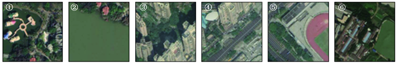
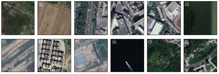
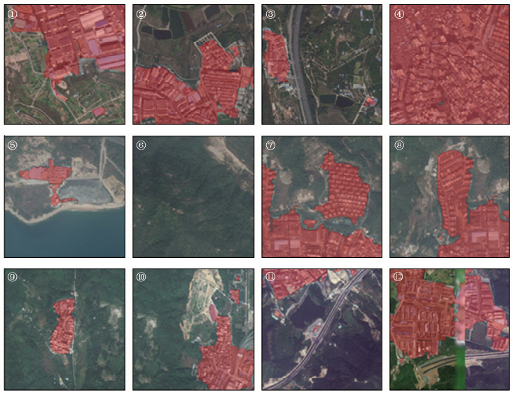
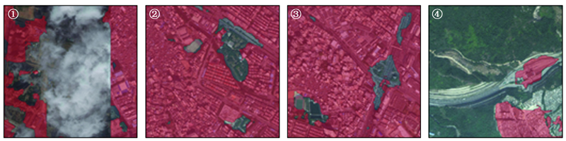
Abstract The extraction of urban built-up areas plays an important role in urban development planning. To find out the method of extracting remote sensing image urban built-up area based on convolutional neural network which can balance efficiency and recognition accuracy, the authors started with the principle of neural network structure and compared as well as analyzed the internal structure of multiple semantic segmentation networks. The semantic segmentation network was trained separately and the results were comparatively studied. The experimental result shows that the ShelfNet-50 network could ensure high recognition accuracy while training speed, achieved 77% foreground segmentation accuracy while training time was only 14 hours, and the result of ShelfNet-50 network prediction was also highly consistent with the corresponding remote sensing image data. The experiment confirms that ShelfNet-50 network can be applied to high-resolution remote sensing image urban built-up area extraction problems.
|
| Keywords
high-resolution remote sensing image
convolutional neural network
semantic segmentation
urban built-up area
|
|
|
|
Corresponding Authors:
ZHAO Tong
E-mail: liuz@tsinghua.edu.cn;zhaot18@mails.tsinghua.edu.cn
|
|
Issue Date: 18 March 2021
|
|
|
| [1] |
中华人民共和国建设部. 城市规划基本术语标准:GB/T50280—1998[S]. 北京:工程建设标准全文信息系统, 1999.
|
| [1] |
Ministry of Construction of the People’s Republic of China. Basic terminology standard for urban planning:GB/T50280—1998[S]. Beijing:Engineering Construction Standard Full-Text Information System, 1999.
|
| [2] |
Sinha P, Verma N K, Ayele E. Urban built-up area extraction and change detection of Adama municipal area using time-series Landsat images[J]. International Journal of Advanced Remote Sensing and GIS, 2016,5(8):1886-1895.
|
| [3] |
Zha Y, Gao J, Ni S. Use of normalized difference built-up index in automatically mapping urban areas from TM imagery[J]. International Journal of Remote Sensing, 2003,24(3):583-594.
|
| [4] |
陈志强, 陈健飞. 基于NDBI指数法的城镇用地影像识别分析与制图[J]. 地球信息科学学报, 2012,8(2):137-140.
|
| [4] |
Chen Z Q, Chen J F. Urban land image recognition analysis and mapping based on NDBI index method[J]. Geo-Information Science, 2012,8(2):137-140.
|
| [5] |
梁珊, 刘荣, 祖帅, 等. 基于多光谱遥感影像的城市建设用地提取及扩张分析[J]. 测绘与空间地理信息, 2018,41(6):74-78.
|
| [5] |
Liang S, Liu R, Zu S, et al. Urban construction land extraction and expansion analysis based on multi-spectral remote sensing images[J]. Geomatics and Spatial Geographic Information, 2018,41(6):74-78.
|
| [6] |
Liaw A, Wiener M. Classification and regression by random forest[J]. R News, 2002,2(3):18-22.
|
| [7] |
Burges C J C. A tutorial on support vector machines for pattern reco-gnition[J]. Data Mining and Knowledge Discovery, 1998,2(2):121-167.
|
| [8] |
Gowthami K, Thilagavathi K. Built-up area detection of remote sensing images using static clustering technique[C]// 2014 International Conference on Electronics and Communication Systems(ICECS).IEEE, 2014: 1-5.
|
| [9] |
Gong P, Liu H, Zhang M, et al. STab.classification with limited sample:Transferring a 30-m resolution sample set collected in 2015 to mapping 10-m resolution global land cover in 2017[J]. Science Bulletin, 2019,64(6):370-373.
doi: 10.1016/j.scib.2019.03.002
url: https://linkinghub.elsevier.com/retrieve/pii/S2095927319301380
|
| [10] |
LeCun Y, Boser B, Denker J S, et al. Backpropagation applied to handwritten zip code recognition[J]. Neural Computation, 1989,1(4):541-551.
|
| [11] |
Krizhevsky A, Sutskever I, Hinton G E. Imagenet classification with deep convolutional neural networks[C]// Advances in Neural Information Processing Systems, 2012: 1097-1105.
|
| [12] |
杨建宇, 周振旭, 杜贞容, 等. 基于SegNet语义模型的高分辨率遥感影像农村建设用地提取[J]. 农业工程学报, 2019,35(5):259-266.
|
| [12] |
Yang J Y, Zhou Z X, Du Z R, et al. High-resolution remote sensing imagery rural construction land extraction based on SegNet semantic model[J]. Transactions of the Chinese Society of Agricultural Engineering, 2019,35(5):259-266.
|
| [13] |
Badrinarayanan V, Kendall A, Cipolla R. Segnet:A deep convolutional encoder-decoder architecture for image segmentation[J]. IEEE Transactions on Pattern Analysis and Machine Intelligence, 2017,39(12):2481-2495.
doi: 10.1109/TPAMI.2016.2644615
pmid: 28060704
url: https://www.ncbi.nlm.nih.gov/pubmed/28060704
|
| [14] |
苏健民, 杨岚心, 景维鹏. 基于U-Net的高分辨率遥感图像语义分割方法[J]. 计算机工程与应用, 2019,55(7):212-218.
|
| [14] |
Su J M, Yang L X, Jing W P. High-resolution remote sensing image semantic segmentation method based on U-Net[J]. Computer Engineering and Applications, 2019,55(7):212-218.
|
| [15] |
Ronneberger O, Fischer P, Brox T. U-net:Convolutional networks for biomedical image segmentation[C]// International Conference on Medical Image Computing and Computer-Assisted Intervention.Springer,Cham.Berlin,German:Springer, 2015: 234-241.
|
| [16] |
Chen L C, Papandreou G, Schroff F. et al. Rethinking atrous convolution for semantic image segmentation[EB/OL].12017-12-05. http://arxiv.org/odf/1706.05587.pdf.
url: http://arxiv.org/odf/1706.05587.pdf
|
| [17] |
Yu F, Koltun V. Multi-scale context aggregation by dilated convolutions[J/OL]. [2019-05-30].https://arxiv.org/abs/1511.07122.pdf.
url: https://arxiv.org/abs/1511.07122.pdf
|
| [18] |
王俊强, 李建胜, 周华春, 等. 基于Deeplabv3+与CRF的遥感影像典型要素提取方法[J]. 计算机工程, 2019,45(10):260-265,271.
|
| [18] |
Wang J Q, Li J S, Zhou H C, et al. Typical elements extraction method of remote sensing image based on Deeplabv3+ and CRF[J]. Computer Engineering, 2019,45(10):260-265,271.
|
| [19] |
He K M, Zhang X Y, Ren S Q, et al. Deep residual learning for image recognition[C]// Proceedings of the IEEE Conference on Computer Vision and Pattern Recognition.Piscataway,NJ:IEEE, 2016: 770-778.
|
| [20] |
Zhao H S, Shi J P, Qi X J, et al. Pyramid scene parsing network[C]// Proceedings of the IEEE Conference on Computer Vision and Pattern Recognition.Piscataway,NJ:IEEE, 2017: 2881-2890.
|
| [21] |
Zhuang J T, Yang J L, Gu L, et al. ShelfNet for real-time semantic segmentation[EB/OL].(2018-11-27). http://arxiv.org/pdf/1811.11254 vl.pdf.
url: http://arxiv.org/pdf/1811.11254 vl.pdf
|
| [22] |
Simonyan K, Zisserman A. Very deep convolutional networks for large-scale image recognition[EB/OL].(2014-09-04). http://arxiv.org/pdf//1409.1556 vl.pdf.
url: http://arxiv.org/pdf//1409.1556 vl.pdf
|
|
Viewed |
|
|
|
Full text
|
|
|
|
|
Abstract
|
|
|
|
|
Cited |
|
|
|
|
| |
Shared |
|
|
|
|
| |
Discussed |
|
|
|
|
 2021,
Vol. 33
2021,
Vol. 33
 ), ZHAO Tong(