Please wait a minute...
 
Remote Sensing for Natural Resources    2022, Vol. 34 Issue (1) : 85-92     DOI: 10.6046/zrzyyg.2021035
|
A method for extracting match pairs of UAV images considering geospatial information
REN Chaofeng(), PU Yuchi, ZHANG Fuqiang
College of Geological Engineering and Geomatics, Chang’an University, Xi’an 710054, China
Download: PDF(3432 KB)   HTML
Export: BibTeX | EndNote | Reference Manager | ProCite | RefWorks    
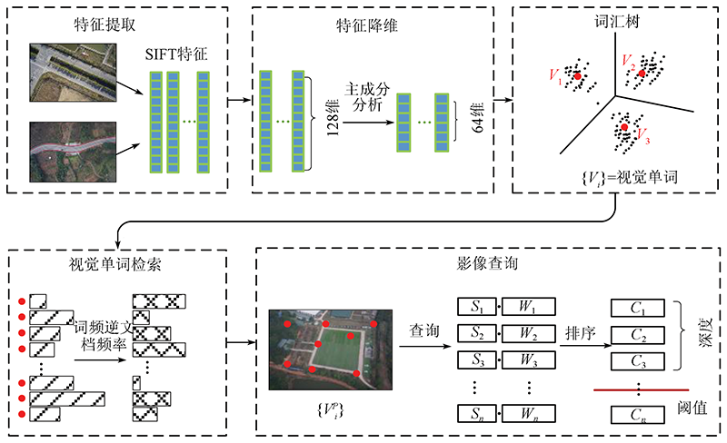
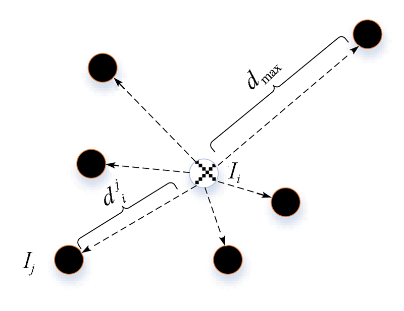
Abstract  

To overcome the shortcomings such as poor adaptability, low efficiency, and the demand for prior knowledge in the 3D reconstruction using UAV images, this study proposed a method for extracting match pairs of UAV images considering geospatial information. The steps of this method are stated as follows. Firstly, reduce high-dimensional features of the images to low-dimensional features using the principal component analysis (PCA) method to improve the construction efficiency of the retrieval vocabulary. Secondly, construct a comprehensive retrieval factor by calculating the inverse distance weighting factor between query images to improve the distinguishability between similar images. Finally, discard invalid match pairs by calculating the retrieval threshold to improve the query precision of images. The experimental results show that, compared to the traditional footprint map method and 128-dimensional feature retrieval method, this method enjoys higher processing efficiency and more comprehensive sparse reconstruction results, especially for the massive UAV data.

Keywords match pairs      bag of visual words      UAV      3D reconstruction      image retrieval     
ZTFLH:  TP79  
Issue Date: 14 March 2022
Service
E-mail this article
E-mail Alert
RSS
Articles by authors
Chaofeng REN
Yuchi PU
Fuqiang ZHANG
Cite this article:   
Chaofeng REN,Yuchi PU,Fuqiang ZHANG. A method for extracting match pairs of UAV images considering geospatial information[J]. Remote Sensing for Natural Resources, 2022, 34(1): 85-92.
URL:  
https://www.gtzyyg.com/EN/10.6046/zrzyyg.2021035     OR     https://www.gtzyyg.com/EN/Y2022/V34/I1/85
Fig.1  Flowchart of UAV image pairs extraction method referring to image geospatial information
Fig.2  Inverse distance weighting factor
Fig.3  Query depth threshold
数据 传感器 采集方式 数据类型 位置 主要地形 影像大小/像素 影像数量/幅 采集时间 地面分辨率/cm
A 单相机 等高 正射 陕西省华阳乡 高山峡谷 7 952×5 304 1 659 2018-02-12 4
B 单相机 变高 正射 贵州省鸡场镇 高山滑坡 5 472×3 648 465 2019-07-25 10
C 单相机 等高/贴近 正射/倾斜 贵州省鬃岭镇 高山滑坡 5 472×3 648 2 137 2019-07-29 8/1
D 双相机 等高 倾斜 山西省平陆县 丘陵 7 952×5 304 2 728 2019-04-07 2
E 五相机 等高 倾斜 陕西省大同市 城市 6 000×4 000 8 585 2019-08-26 2
Tab.1  Experimental UAV images dataset
Fig.4  Image precision and recall of different dimensional models
Fig.5  Similarity factors and comprehensive factor curves
Fig.6  Partial query images

数据
查准率 查全率
查询深度
Q
128维 96维 64维 64G 128维 96维 64维 64G
数据C 100 88.66 87.95 86.78 90.91 23.82 25.79 27.60 23.92
200 82.91 79.26 75.77 83.01 46.41 48.96 50.56 44.26
300 74.43 64.91 60.27 75.49 63.67 61.39 62.87 64.49
数据D 100 99.22 99.03 98.81 99.79 29.76 33.44 37.03 31.98
200 91.47 88.87 86.75 95.30 60.96 64.27 68.20 63.34
300 77.83 72.94 68.20 83.99 78.42 78.91 80.76 82.01
数据E 100 73.36 76.64 73.76 86.11 52.52 56.84 60.43 55.93
200 35.64 44.86 46.14 59.40 55.72 69.19 77.56 78.02
300 29.06 35.00 33.09 43.74 66.21 79.23 84.34 85.77
Tab.2  Precision and recall of different query depths(%)
数据 方法 词汇树/min 索引/min 检索/min 双像匹配/min 稀疏重建/min 连接点 成功数 总数 投影误差/像素
数据A 脚印图 4.20 28.81 362 822 1 591 1 591 0.70
128维 5.34 1.70 1.38 6.66 30.36 332 736 1 581 1 659 0.70
64G 3.55 1.17 2.12 1.26 28.24 364 783 1 591 1 659 0.70
数据B 脚印图 4.64 5.17 121 527 465 465 0.70
128维 5.29 0.49 0.31 1.54 4.94 119 183 465 465 0.70
64G 3.46 0.24 0.35 0.63 5.20 115 048 465 465 0.70
数据C 脚印图 11.28 61.69 299 041 1 634 2 137 0.72
128维 5.12 1.35 1.27 8.12 58.60 323 224 2 100 2 137 0.73
64G 3.44 0.82 1.52 3.79 58.49 338 049 2 123 2 137 0.72
数据D 脚印图 16.67 103.17 367 247 2 728 2 728 0.75
128维 5.23 0.94 0.62 26.01 105.41 367 238 2 728 2 728 0.75
64G 3.44 0.46 1.54 7.35 103.38 375 990 2 728 2 728 0.75
数据E 脚印图 83.50 3 096.26 1 342 650 8 585 8 585 0.71
128 11.80 11.89 9.92 61.10 2 169.59 1 344 968 8 585 8 585 0.71
64G 7.20 9.07 11.56 17.89 2 085.62 1 488 024 8 585 8 585 0.70
Tab.3  Efficiency, integrity and accuracy of sparse reconstruction
Fig.7  Sparse reconstruction results of image pairs extracted by the proposed method
[1] 雷添杰, 李长春, 何孝莹. 无人机航空遥感系统在灾害应急救援中的应用[J]. 自然灾害学报, 2011, 20(1):178-183.
[1] Lei T J, Li C C, He X Y. Application of aerial remote sensing of pilotless aircraft to disaster emergency rescue[J]. Journal of Natural Disasters, 2011, 20(1):178-183.
[2] 李明, 张卫龙, 范丁元. 城市三维重建中的自动纹理优化方法[J]. 测绘学报, 2017, 46(3):338-345.
[2] Li M, Zhang W L, Fan D Y. Automatic texture optimization for 3D urban reconstruction[J]. Acta Geodaetica et Cartographica Sinica, 2017, 46(3):338-345.
[3] 黄海峰, 易武, 张国栋, 等. 引入小型无人机遥感的滑坡应急治理勘察设计方法[J]. 防灾减灾工程学报, 2017, 37(1):99-104.
[3] Huang H F, Yi W, Zhang G D, et al. Method of using micro-VAVRS in engineering geological investigation and design for emergency control of landslides[J]. Journal of Disaster Prevention and Mitigation Engineering, 2017, 37(1):99-104.
[4] 于丙辰, 陈刚, 段淼然, 等. 无人机遥感在大型不可移动文物三维重建中的应用[J]. 测绘通报, 2017(5):43-46.
[4] Yu B C, Chen G, Duan M R, et al. UAV RS applied in 3D reconstruction of huge immovable cultural relics[J]. Bulletin of Surveying and Mapping, 2017(5):43-46.
[5] 何海清. 低空摄影测量航带重构及数据处理方法研究[J]. 测绘学报, 2014, 43(40):440.
[5] He H Q. The study of strips reconstruction oriented data processing methodology in low-altitude photogrammetry[J]. Acta Geodaetica et Cartographica Sinica, 2014, 43(4):440.
[6] 肖熊武, 郭丙轩, 李德仁, 等. 一种具有仿射不变性的倾斜影像快速匹配方法[J]. 测绘学报, 2015, 44(4):414-421.
[6] Xiao X W, Guo B X, Li D R, et al. A quick and affine invariance matching method for oblique images[J]. Acta Geodaetica et Cartographica Sinica,2015, 44(4):414-421.
[7] 闫利, 费亮, 叶志云, 等. 大范围倾斜多视影像连接点自动提取的区域网平差法[J]. 测绘学报, 2016, 45(3):310-317.
[7] Yan L, Fei L, Ye Z Y, et al. Automatic tie-points extraction for triangulation of large-scale oblique multi-view images[J]. Acta Geodaetica et Cartographica Sinica, 2016, 45(3):310-317.
[8] David G L. Distinctive image feature from scale-invariant keypoints[J]. International Journal of Computer Vision, 2004, 60(2):91-110.
doi: 10.1023/B:VISI.0000029664.99615.94 url: http://link.springer.com/10.1023/B:VISI.0000029664.99615.94
[9] Morel J M, Yu G. ASIFT:A new framework for fully affine invariant image comparison[J]. SIAM Journal on Imaging Sciences, 2009, 2(2):438-469.
doi: 10.1137/080732730 url: http://epubs.siam.org/doi/10.1137/080732730
[10] Wu C. SiftGPU:A GPU implementation of scale invariant feature transform(SIFT)[EB/OL].(2013 -03-11)[2021-02-07].https://github.com/pitzer/SiftGPU.
url: https://github.com/pitzer/SiftGPU.
[11] Agarwal S, Snavely N, Simon I, et al. Building rome in a day[C]// 12th International Conference on Computer Vision.IEEE, 2009:72-79.
[12] Snavely N, Seitz S, Szeliski R. Photo tourism:Exploring photo collections in 3D[C]// Special Interest Group on Computer Graphics and Interactive Techniques Conference.ACM, 2006, 25(3):835-846.
[13] Johannes L, Schonberger,Frahm J M.Structure-from-motion revisited[C]// 2016 IEEE Conference on Computer Vision and Pattern Recognition.IEEE, 2016:1-10.
[14] 任超锋, 彭晓东. 低空无人机影像匹配像对的提取方法[J]. 测绘工程, 2019, 28(6):36-41.
[14] Ren C F, Peng X D. Extraction method of image pairs for low-altitude UAV image matching[J]. Engineering of Surveying and Mapping, 2019, 28(6):36-41.
[15] 李劲澎, 姜挺, 肖达, 等. 基于关系图的无人机影像三维重建[J]. 光学精密工程, 2016, 24(6):1501-1509.
[15] Li J P, Jiang T, Xiao D, et al. On diagram-based three-dimensional reconstruction of UAV image[J]. Optics and Prcesion Engineering, 2016, 24(6):1501-1509.
[16] 姜三, 许志海, 张峰, 等. 面向无人机倾斜影像的高效SfM重建方案[J]. 武汉大学学报(信息科学版), 2019, 44(8):1153-1160.
[16] Jiang S, Xu Z H, Zhang F, et al. Solution for efficient SfM reconstruction of oblique UAV images[J]. Geomatics and Information Science of Wuhan University, 2019, 44(8):1153-1160.
[17] Sivic J, Zisserman A. Video Google:A text retrieval approach to object matching in videos[C]// International Conference on Computer Vision.IEEE, 2003:1470-1477.
[18] Jegou H, Douze M, Schmid C. Hamming embedding and weak geometric consistency for large scale image search[C]// European Conference on Computer Vsion, 2008:304-317.
[19] Schönberger J L, Price T, Sattler T, et al. A vote-and-verify strategy for fast spatial verification in image retrieval[C]// Asian Conference on Computer Vision.Springer, 2016:321-337.
[20] Nister D, Stevenisu H. Scalable recognition with a vocabulary tree[C]// Computer Society Conference on Computer Vision and Pattern Recognition.IEEE, 2006:2161-2168.
[1] WANG Zhenhua, TAN Zhilian, LI Jing, CHANG Yingli. Re-YOLOX: A YOLOX model for identifying nearshore monitoring targets improved based on the Resizer model[J]. Remote Sensing for Natural Resources, 2023, 35(3): 10-16.
[2] CHEN Kai, WANG Chun, DAI Wen, SHENG Yehua, LIU Aili, TANG Guoan. Factors influencing the terrain modeling accuracy of UAV photogrammetry based on Monte Carlo tests of control points[J]. Remote Sensing for Natural Resources, 2023, 35(3): 107-115.
[3] DONG Shuangfa, FAN Xiao, SHI Haigang, XU Liping, ZHANG Xinyi. Study on distribution of thermal discharge in Fuqing nuclear power plant based on Landsat8 and UAV[J]. Remote Sensing for Natural Resources, 2022, 34(3): 112-120.
[4] ZHANG Shu, ZHOU Zhongfa, WANG Lingyu, CHEN Quan, LUO Jiancheng, ZHAO Xin. Inversion of moisture in surface soil of farmland in karst mountainous areas using multi-temporal SAR images[J]. Remote Sensing for Natural Resources, 2022, 34(3): 154-163.
[5] ZHAO Xiaowei, HUANG Yang, WANG Yongqiang, CHU Ding. Estimation of maize seedling number based on UAV multispectral data[J]. Remote Sensing for Natural Resources, 2022, 34(1): 106-114.
[6] WU Fang, LI Yu, JIN Dingjian, LI Tianqi, GUO Hua, ZHANG Qijie. Application of 3D information extraction technology of ground obstacles in the flight trajectory planning of UAV airborne geophysical exploration[J]. Remote Sensing for Natural Resources, 2022, 34(1): 286-292.
[7] ZANG Chuankai, SHEN Fang, YANG Zhengdong. Aquatic environmental monitoring of inland waters based on UAV hyperspectral remote sensing[J]. Remote Sensing for Natural Resources, 2021, 33(3): 45-53.
[8] LI Yang, YUAN Lin, ZHAO Zhiyuan, ZHANG Jinlei, WANG Xianye, ZHANG Liquan. Inversion of tidal flat topography based on unmanned aerial vehicle low-altitude remote sensing and field surveys[J]. Remote Sensing for Natural Resources, 2021, 33(3): 80-88.
[9] LIU Yongmei, FAN Hongjian, GE Xinghua, LIU Jianhong, WANG Lei. Estimation accuracy of fractional vegetation cover based on normalized difference vegetation index and UAV hyperspectral images[J]. Remote Sensing for Natural Resources, 2021, 33(3): 11-17.
[10] BAI Junlong, WANG Zhangqiong, YAN Haitao. A K-means clustering-guided threshold-based approach to classifying UAV remote sensed images[J]. Remote Sensing for Natural Resources, 2021, 33(3): 114-120.
[11] BI Weihua, ZHAO Xingtao, YANG Huachao, BIAN Hefang, ZHANG Qiuzhao. Research on smartphone based UAV low-altitude oblique photogrammetry system and its applications[J]. Remote Sensing for Land & Resources, 2021, 33(2): 248-255.
[12] XIONG Yujiu, ZHAO Shaohua, YAN Chunhua, QIU Gouyu, SUN Hua, WANG Yanlin, QIN Longjun. A comparative study of methods for monitoring and assessing urban green space resources at multiple scales[J]. Remote Sensing for Land & Resources, 2021, 33(1): 54-62.
[13] CAI Xiang, LI Qi, LUO Yan, QI Jiandong. Surface features extraction of mining area image based on object-oriented and deep-learning method[J]. Remote Sensing for Land & Resources, 2021, 33(1): 63-71.
[14] XIA Yan, HUANG Liang, CHEN Pengdi. Tobacco fine extraction from UAV image based on fuzzy-superpixel segmentation algorithm[J]. Remote Sensing for Land & Resources, 2021, 33(1): 115-122.
[15] WANG Wei, WANG Xinsheng, YAO Chan, JIN Tian, WU Jiayu, SU Wei. Estimation of wheat planting density using UAV image[J]. Remote Sensing for Land & Resources, 2020, 32(4): 111-119.
Viewed
Full text


Abstract

Cited

  Shared   
  Discussed   
京ICP备05055290号-2
Copyright © 2017 Remote Sensing for Natural Resources
Support by Beijing Magtech