|
|
 |
|

|
|
|
The remote sensing inversion and validation of land surface temperature based on ASTER data: A case study of the Heihe River basin |
MA Junjun1,2( ), WANG Chunlei3, HUANG Xiaohong1,2() ), WANG Chunlei3, HUANG Xiaohong1,2() |
1. School of Artificial Intelligence, North China University of Technology, Tangshan 063210, China
2. Hebei Provincial Key Laboratory of Industrial Intelligent Perception, North China University of Technology, Tangshan 063210, China
3. Consulting & Research Center of Ministry of Natural Resources, Beijing 100100, China |
|
|
|
|
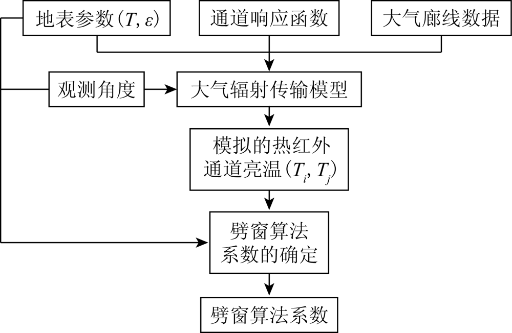
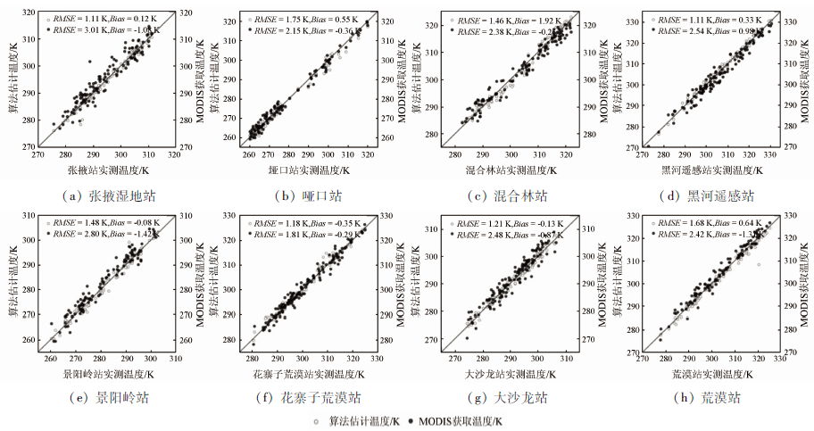
Abstract Given the land surface types and atmospheric features of the Heihe River basin, this study calculated the surface emissivity of the study area using the ASTER Global Emissivity Database and the vegetation cover method (VCM) and estimated the atmospheric water vapor content using the improved multilayer feed-forward neural network (MFNN). Moreover, by establishing the coefficient lookup table of input parameter groups, this study developed an ASTER data-based split-window algorithm for the remote sensing inversion of land surface temperature. To validate the applicability and accuracy of the split-window algorithm, this study elevated the algorithm using the measured site data on the land surface temperature of the Heihe River basin in 2019 and MODIS instruments. Compared with the site data, the results of the split-window algorithm had root mean square errors of 1.81~3.01 K. In the cross-validation using the MODIS instruments, the split-window algorithm had relatively small errors and deviations, with root mean square errors of 1.11~1.75 K. Overall, the accuracy of the land surface temperature obtained from the inversion using the split-window algorithm can meet the needs of meteorological and climatological studies. Moreover, the development philosophy of the split-window algorithm can be used as a reference for similar thermal infrared sensors.
|
| Keywords
ASTER data
land surface temperature
cross-validation
|
|
|
|
Issue Date: 20 March 2023
|
|
|
| [1] |
李召良, 段四波, 唐伯惠, 等. 热红外地表温度遥感反演方法研究进展[J]. 遥感学报, 2016, 20(5):899-920.
|
| [1] |
Li Z L, Duan S B, Tang B H, et al. Research progress in inversion methods of thermal infrared land surface temperature remote sensing[J]. Journal of Remote Sensing, 2016, 20(5):899-920.
|
| [2] |
Anderson M C, Kustas W P, Norman J M, et al. Mapping daily evapotranspiration at field to continental scales using geostationary and polar orbiting satellite imagery[J]. Hydrology and Earth System Sciences, 2011, 15(1):223-239.
doi: 10.5194/hess-15-223-2011
url: https://hess.copernicus.org/articles/15/223/2011/
|
| [3] |
程博, 刘少峰, 杨巍然. Terra卫星ASTER数据的特点与应用[J]. 华东地质学院学报, 2003(1):15-17.
|
| [3] |
Cheng B, Liu S F, Yang W R. The characteristics and application of Terra satellite ASTER data[J]. Journal of East China Institute of Geology, 2003(1):15-17.
|
| [4] |
Gillespie A, Rokugawa S. A temperature and emissivity separation algorithm for Advanced Spaceborne Thermal Emission and Reflection Radiometer (ASTER) images[J]. IEEE Transactions on Geoscience and Remote Sensing, 1998, 36(4):1113-1126.
doi: 10.1109/36.700995
url: http://ieeexplore.ieee.org/document/700995/
|
| [5] |
杨杭, 张立福, 张学文, 等. TASI数据的温度与发射率分离算法[J]. 遥感学报, 2011, 15(6):1248-1264.
|
| [5] |
Yang H, Zhang L F, Zhang X W, et al. The separation algorithm of temperature and emissivity for TASI data[J]. Journal of Remote Sensing, 2011, 15(6):1248-1264.
|
| [6] |
张允祥, 李新, 韦玮, 等. 基于多通道温度与发射率分离算法的敦煌场地红外特性研究[J]. 光学学报, 2019, 39(10):309-317.
|
| [6] |
Zhang Y X, Li X, Wei W, et al. Research on infrared characteristics of Dunhuang site based on multi-channel temperature and emissivity separation algorithm[J]. Acta Optics, 2019, 39(10):309-317.
|
| [7] |
McMillin L M. Estimation of sea surface temperatures from two infrared window measurements with different absorption[J]. Journal of Geophysical Research, 1975, 80(36):5113-5117.
doi: 10.1029/JC080i036p05113
url: http://doi.wiley.com/10.1029/JC080i036p05113
|
| [8] |
Price J C. Land surface temperature measurements from the split window channels of the NOAA-7 AVHRR[J]. Journal of Geophysical Research Atmospheres, 1984, 89(5):7231-7237.
doi: 10.1029/JD089iD05p07231
url: http://doi.wiley.com/10.1029/JD089iD05p07231
|
| [9] |
毛克彪, 唐华俊, 陈仲新, 等. 一个从ASTER数据中反演地表温度的分裂窗算法[J]. 遥感信息, 2006(5):7-11.
|
| [9] |
Mao K B, Tang H J, Chen Z X, et al. A split-window algorithm for retrieving land surface temperature from ASTER data[J]. Remote Sensing Information, 2006(5):7-11.
|
| [10] |
孙静, 赵萍, 叶琦. 一种ASTER数据地表温度反演的分裂窗算法[J]. 遥感技术与应用, 2012(5):728-734.
|
| [10] |
Sun J, Zhao P, Ye Q. A split window algorithm for retrieving surface remperature from ASTER data[J]. Remote Sensing Technology and Application, 2012(5):728-734.
|
| [11] |
Wan Z, Dozier J. A generalized split-window algorithm for retrieving land-surface temperature from space[J]. IEEE Transactions on Geoscience & Remote Sensing, 1996, 34(4):892-905.
|
| [12] |
Liu S M, Li X, Xu Z W, et al. The Heihe integrated observatory network:A basin-scale land surface processes observatory in China[J]. Vadose Zone Journal, 2018, 17(1) :1-21.
|
| [13] |
Ri C G, 柳钦火, 历华, 等. 针对Terra/MODIS数据的改进分裂窗地表温度反演算法[J]. 遥感学报, 2013(4):830-840.
|
| [13] |
Ri C G, Liu Q H, Li H, et al. Improved split-window land surface temperature retrieval algorithm for Terra/MODIS data[J]. Journal of Remote Sensing, 2013(4):830-840.
|
| [14] |
Galve J M, Coll C, Caselles V, et al. An atmospheric radiosounding database for generating land surface temperature algorithms[J]. IEEE Transactions on Geoscience & Remote Sensing, 2008, 46(5):1547-1557.
|
| [15] |
李珊珊, 蒋耿明. 基于通用分裂窗算法和Landsat-8数据的地表温度反演研究[J]. 遥感技术与应用, 2018, 33(2):284-295.
|
| [15] |
Li S S, Jiang G M. Research on land surface temperature inversion based on general split window algorithm and Landsat-8 data[J]. Remote Sensing Technology and Application, 2018, 33(2):284-295.
|
| [16] |
Jiang J X, Li H, Liu Q H, et al. Evaluation of land surface temperature retrieval from FY-3B/VIRR data in an arid area of northwestern China[J]. Remote Sensing, 2015, 7(6):7080-7104.
doi: 10.3390/rs70607080
url: http://www.mdpi.com/2072-4292/7/6/7080
|
| [17] |
孟翔晨, 历华, 杜永明, 等. 基于ASTER GED产品的地表发射率估算[J]. 遥感学报, 2016, 20(3):382-396.
|
| [17] |
Meng X C, Li H, Du Y M, et al. Estimation of surface emissivity based on ASTER GED products[J]. Journal of Remote Sensing, 2016, 20(3):382-396.
|
| [18] |
Valor E, Caselles V. Mapping land surface emissivity from NDVI:Application to European,African,and South American areas[J]. Remote Sensing of Environment, 1996, 57(3):167-184.
doi: 10.1016/0034-4257(96)00039-9
url: https://linkinghub.elsevier.com/retrieve/pii/0034425796000399
|
| [19] |
Sobrino J A, Jimenez-Muoz J C, Soria G, et al. Land surface emissivity retrieval from different VNIR and TIR sensors[J]. IEEE Transactions on Geoscience & Remote Sensing, 2008, 46(2):316-327.
|
| [20] |
杨亮彦, 孔金玲, 王雅婷, 等. 旱区大气水汽含量遥感反演算法研究[J]. 测绘科学, 2020, 45(5):95-100.
|
| [20] |
Yang L Y, Kong J L, Wang Y T, et al. Research on remote sensing inversion algorithm of atmospheric water vapor content in arid area[J]. Science of Surveying and Mapping, 2020, 45(5):95-100.
|
| [21] |
李红林, 李万彪. MODIS近红外资料反演大气水汽总含量[J]. 北京大学学报(自然科学版), 2008(1):121-128.
|
| [21] |
Li H L, Li W B. Retrieving total atmospheric water vapor content from MODIS near-infrared data[J]. Journal of Peking University (Natural Science Edition), 2008(1):121-128.
|
| [22] |
Li Z L, Li J, Su Z G, et al. A new approach for retrieving precipitable water from ATSR2 split-window channel data over land area[J]. International Journal of Remote Sensing, 2003, 24(24):5095-5117.
doi: 10.1080/0143116031000096014
url: https://www.tandfonline.com/doi/full/10.1080/0143116031000096014
|
| [23] |
Zhang S, Xu L, Ding J, et al. A neural network based algorithm for the retrieval of precipitable water vapor from MODIS data[J]. Lecture Notes in Electrical Engineering, 2010, 67:909-916.
|
| [24] |
马晋, 周纪, 刘绍民, 等. 卫星遥感地表温度的真实性检验研究进展[J]. 地球科学进展, 2017, 32(6):615-629.
doi: 10.11867/j.issn.1001-8166.2017.06.0615
|
| [24] |
Ma J, Zhou J, Liu S M, et al. Research progress on authenticity verification of satellite remote sensing of land surface temperature[J]. Advances in Earth Science, 2017, 32(6):615-629.
|
| [25] |
Duan S B, Li Z L, Cheng J, et al. Cross-satellite comparison of operational land surface temperature products derived from MODIS and ASTER data over bare soil surfaces-ScienceDirect[J]. ISPRS Journal of Photogrammetry and Remote Sensing, 2017, 126(4):1-10.
doi: 10.1016/j.isprsjprs.2017.02.003
url: https://linkinghub.elsevier.com/retrieve/pii/S0924271616301976
|
| [26] |
Liu Y, Hiyama T, Yamaguchi Y. Scaling of land surface temperature using satellite data:A case examination on ASTER and MODIS products over a heterogeneous terrain area[J]. Remote Sensing of Environment, 2006, 105(2):115-128.
doi: 10.1016/j.rse.2006.06.012
url: https://linkinghub.elsevier.com/retrieve/pii/S0034425706002379
|
|
Viewed |
|
|
|
Full text
|
|
|
|
|
Abstract
|
|
|
|
|
Cited |
|
|
|
|
| |
Shared |
|
|
|
|
| |
Discussed |
|
|
|
|
 2023,
Vol. 35
2023,
Vol. 35