|
|
 |
|

|
|
|
Study of the temporal and spatial evolution law of land surface temperature in China |
Bing ZHAO1, Kebiao MAO2( ), Yulin CAI1, Xiangjin MENG3 ), Yulin CAI1, Xiangjin MENG3 |
1. Geomatics College, Shandong University of Science and Technology, Qingdao 266590, China
2. Institute of Agricultural Resources and Regional Planning, Chinese Academy of Agricultural Sciences, Beijing 100081, China
3. School of Surveying and Geo-Informatics, Shandong Jianzhu University, Jinan 250100, China |
|
|
|
|
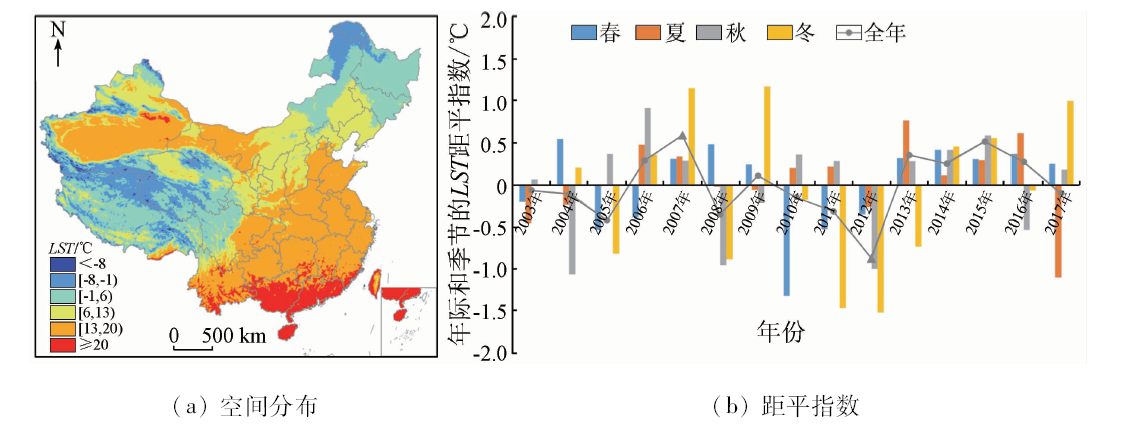
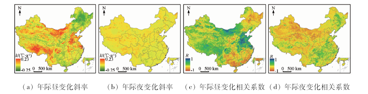
Abstract Land surface temperature (LST) is a key parameter in the surface environment and atmospheric energy exchange system, and it plays an important role in agricultural information monitoring and agro-meteorological disaster research. Due to the interference of factors such as clouds, there are a large number of missing and low-quality pixels in the thermal infrared surface temperature data. Therefore, this study used reconstructed high-quality MODIS surface temperature data as the data source, from 2003 to 2017 year, day and night and season. The spatial and temporal distribution characteristics and long-term variation pattern of China’s surface temperature during 15 years were analyzed systematically on different time scales. The results are as follows: ①During the period of 2003—2017, the surface temperature change in China showed a slight increase in temperature, with an average annual increase of 0.011 ℃, of which 63.7% showed a trend of warming. ②In addition, China’s warming trend is significantly uneven, with the overall characteristics of “the north is greater than the south and the west is greater than the east”. The significant warming is mainly concentrated in the central and western parts of the Inner Mongolia Plateau in the northwestern region, the southern part of Tibet, and the Huanghuaihai Plain (slope k>0.07 ℃·a-1, R>0.6). In addition, the region with the largest temperature drop is concentrated in the vicinity of the Songnen Plain in the northeastern region (change slope k<-0.06 ℃·a-1, R>0.55). ③On the seasonal scale, the warming trend in winter is the fastest, with the most significant in the western region, followed by spring, while the warming trend in autumn and summer does not change much.
|
| Keywords
land surface temperature
time and space change
MODIS
China
|
|
|
|
Corresponding Authors:
Kebiao MAO
E-mail: maokebiao@caas.cn
|
|
Issue Date: 18 June 2020
|
|
|
| [1] |
李召良, 段四波, 唐伯惠, 等. 热红外地表温度遥感反演方法研究进展[J]. 遥感学报, 2016,20(5):899-920.
|
| [1] |
Li Z L, Duan S B, Tang B H, et al. Review of methods for land surface temperature derived from thermal infrared remotely sensed data[J]. Journal of Remote Sensing, 2016,20(5):899-920.
|
| [2] |
Li Z L, Wu H, Wang N, et al. Land surface emissivity retrieval from satellite data[J]. International Journal of Remote Sensing, 2013,34(9-10):3084-3127.
|
| [3] |
Wan Z M. New refinements and validation of the collection-6 MODIS land-surface temperature/emissivity product[J]. Remote Sensing of Environment, 2014,140:36-45.
doi: 10.1016/j.rse.2013.08.027
url: https://linkinghub.elsevier.com/retrieve/pii/S003442571300285X
|
| [4] |
孙灏, 陈云浩, 孙洪泉. 典型农业干旱遥感监测指数的比较及分类体系[J]. 农业工程学报, 2012,28(14):147-154.
|
| [4] |
Sun H, Chen Y H, Sun H Q. Comparisons and classification system of typical remote sensing indexes for agricultural drought[J]. Transactions of the Chinese Society of Agricultural Engineering, 2012,28(14):147-154.
|
| [5] |
Quattrochi D A, Luvall J C. Thermal infrared remote sensing for analysis of landscape ecological processes:Methods and applications[J]. Landscape Ecology, 1999,14(6):577-598.
|
| [6] |
Green R M, Hay S I. The potential of Pathfinder AVHRR data for providing surrogate climatic variables across Africa and Europe for epidemiological applications[J]. Remote Sensing of Environment, 2002,79(2-3):166-175.
|
| [7] |
徐永明, 覃志豪, 万洪秀. 热红外遥感反演近地层气温的研究进展[J]. 国土资源遥感, 2011,23(1):9-14.doi: 10.6046/gtzyyg.2011.01.02.
|
| [7] |
Xu Y M, Qin Z H, Wan H X. Advances in the study of near surface air temperature retrieval from thermal infrared remote sensing[J]. Remote Sensing for Land and Resources, 2011,23(1):9-14.doi: 10.6046/gtzyyg.2011.01.02.
|
| [8] |
Vancutsem C, Ceccato P, Dinku T, et al. Evaluation of MODIS land surface temperature data to estimate air temperature in different ecosystems over Africa[J]. Remote Sensing of Environment, 2010,114(2):449-465.
|
| [9] |
Mao K B, Ma Y, Tan X L. Global surface temperature change analysis based on MODIS data in recent twelve years[J]. Advances in Space Research, 2017,59(2), 503-512.
|
| [10] |
Mao K, Qin Z, Shi J, et al. A practical split-window algorithm for retrieving land-surface temperature from MODIS data[J]. International Journal of Remote Sensing, 2005,26(15):3181-3204.
|
| [11] |
朱焱, 刘红年, 沈建, 等. 苏州城市热岛对污染扩散的影响[J]. 高原气象, 2016,35(06):1584-1594.
|
| [11] |
Zhu Y, Liu H N, Shen J, et al. Influence of urban heat island on pollution diffusion in Suzhou[J]. Plateau Meteorology, 2016,35(06):1584-1594.
|
| [12] |
谢启姣. 武汉城市热岛特征及其影响因素分析[J]. 长江流域资源与环境, 2016,25(3):462-469.
|
| [12] |
Xie Q J. Analysis on characteristics and influencing factors of urban heat island effect in Wuhan[J]. Resources and Environment in the Yangtze Basin, 2016,25(3):462-469.
|
| [13] |
刘勇洪, 徐永明, 马京津, 等. 北京城市热岛的定量监测及规划模拟研究[J]. 生态环境学报, 2014,23(7):1156-1163.
|
| [13] |
Liu H Y, Xu Y M, Ma J J, et al. Quantitative assessment and planning simulation of Beijing urban heat island[J]. Ecology and Environment Sciences, 2014,23(7):1156-1163.
|
| [14] |
Metz M, Rocchini D, Neteler M. Surface Temperatures at the continental scale:Tracking changes with remote sensing at unprecedented detail[J]. Remote Sensing, 2014,6(5), 3822-3840.
|
| [15] |
Crosson W L, Al-Hamdan M Z, Hemmings S N J, et al.A daily merged MODIS Aqua-Terra land surface temperature dataset for the conterminous United States[J]. Remote Sensing of Environment, 2012 119, 315-324.
|
| [16] |
Mao K B, Yuan Z J, Zuo Z Y, et al. Changes in global cloud cover based on remote sens data from 2003 to 2012[J], Chinese Geographical Science, 2019,29(2), 306-315.
|
| [17] |
张军, 覃志豪, 刘梅, 等. 利用空间插值法估算云覆盖像元地表温度的可行性研究[J]. 地理与地理信息科学, 2011,27(6):45-49,115.
|
| [17] |
Zhang J, Qin Z H Liu M, , et al. Estimating of land surface temperature under the cloud cover with spatial interpolation[J]. Geography and Geo-Information Science, 2011,27(6):45-49,115.
|
| [18] |
Sun X B, Ren G Y, Ren Y Y, et al. A remarkable climate warming hiatus over northeast China since 1998[J]. Theoretical and Applied Climatology, 2018,133:579-594.
doi: 10.1007/s00704-017-2205-7
url: http://link.springer.com/10.1007/s00704-017-2205-7
|
| [19] |
黄小燕, 张明军, 贾文雄, 等. 中国西北地区地表干湿变化及影响因素[J]. 水科学进展, 2011,22(2):151-159.
|
| [19] |
Huang X Y, Zhang M J, Jia W X, et al. Variations of surface humidity and its influential factors in northwest China[J]. Advances in Water Science, 2011,22(2):151-159.
|
| [20] |
柴荣繁, 陈海山, 孙善磊. 基于SPEI的中国干湿变化趋势归因分析[J]. 气象科学, 2018,38(4):423-431.
|
| [20] |
Cai R F, Chen H S, Sun S L. Attribution analysis of dryness/wetness change over China based on SPEI[J]. Journal of the Meteorological Sciences, 2018,38(4):423-431.
|
| [21] |
Liu X, Zhang D, Luo Y, et al. Spatial and temporal changes in aridity index in northwest China:1960 to 2010[J]. Theoretical and Applied Climatology, 2012,112(1-2), 307-316.
|
| [22] |
Duan A, Xiao Z. Does the climate warming hiatus exist over the Tibetan Plateau?[J]. Scientific Reports, 2015,5(1):1-9.
|
| [23] |
Li B, Chen Y, Shi X. Why does the temperature rise faster in the arid region of northwest China?[J]. Journal of Geophysical Research:Atmospheres, 2012,117(D16), 1-7.
|
|
Viewed |
|
|
|
Full text
|
|
|
|
|
Abstract
|
|
|
|
|
Cited |
|
|
|
|
| |
Shared |
|
|
|
|
| |
Discussed |
|
|
|
|
 2020,
Vol. 32
2020,
Vol. 32