|
|
|
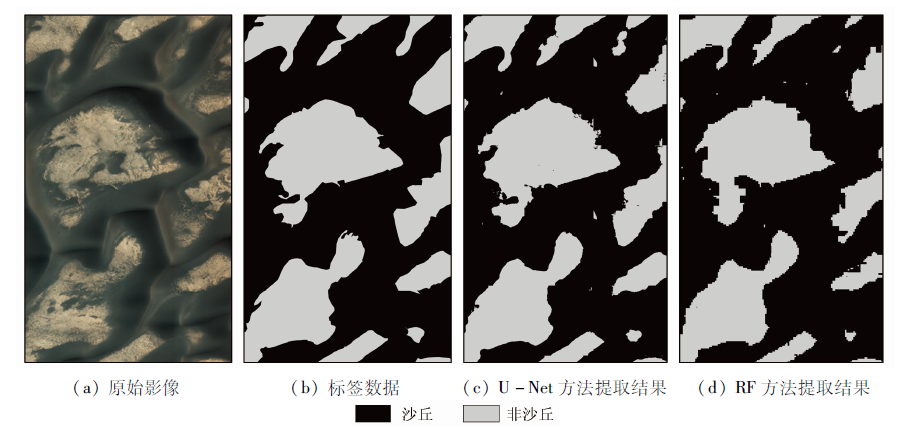
Abstract The remote sensing-based information recognition of Mars dunes has important significance for the exploration of the interactions between the Martian atmosphere and the dune surface. Aiming at the low accuracy of the automatic information extraction of Mars dunes using the traditional machine learning method, this paper designs a method combining texture feature extraction and deep learning to automatically identify the information of Mars dunes. In detail, this method conducts information extraction based on the texture feature extraction of Mars remote sensing images combined with a deep learning model, thus realizing the end-to-end semantic segmentation of the remote sensing images. According to experiment results, the U-Net method can fully utilize the rich texture information in the remote sensing images and the extraction accuracy of dunes of this method was 96.7%, which was 3.2 percentage points higher than that of the traditional random forest method. Furthermore, compared to the traditional random forest method, the U-net method extracted more accurate and clearer contours of Mars dunes and yielded better extraction effects of highly fragmented dunes. Therefore, the U-net method can be used for accurate and automatic information extraction of Mars dunes.
|
| Keywords
Mars dunes
deep learning
random forest
texture feature
automated extraction
|
|
|
|
Issue Date: 23 December 2021
|
|
|
| [1] |
董治宝, 吕萍. 70年来中国风沙地貌学的发展[J]. 地理学报, 2020,75(3):509-528.
doi: 10.11821/dlxb202003006
|
| [1] |
Dong Z B, Lyu P. Development of aeolian geomorphology in China in the past 70 years[J]. Acta Geographica Sinca, 2020,75(3):509-528.
|
| [2] |
Carrera D, Bandeira L, Santana R, et al. Detection of sand dunes on Mars using a regular vine-based classification approach[J]. Knowledge-Based Systems, 2019,163:858-874.
doi: 10.1016/j.knosys.2018.10.011
|
| [3] |
Zurek R W, Smrekar S E. An overview of the Mars reconnaissance orbiter (MRO) science mission[J]. Journal of Geophysical Research-Planets, 2007,112(e5):5-1.
|
| [4] |
Hayward R K, Mullins K F, Fenton L K, et al. Mars global digital dune database and initial science results[J]. Journal of Geophysical Research-Planets, 2007,112(e11):E11007.
doi: 10.1029/2007JE002943
url: http://doi.wiley.com/10.1029/2007JE002943
|
| [5] |
Bandeira L, Marques J S, Saraiva J, et al. Automated detection of Martian dune fields[J]. IEEE Geoscience and Remote Sensing Letters, 2011,8(4):626-630.
doi: 10.1109/LGRS.2010.2098390
url: http://ieeexplore.ieee.org/document/5692810/
|
| [6] |
Bandeira L, Marques J S, Saraiva J, et al. Advances in automated detection of sand dunes on Mars[J]. Earth Surface Processes and Landforms, 2013,38(3):275-283.
doi: 10.1002/esp.v38.3
url: http://doi.wiley.com/10.1002/esp.v38.3
|
| [7] |
Zhao W D, Li S S, Li A, et al. Hyperspectral images classification with convolutional neural network and textural feature using limited training samples[J]. Remote Sensing Letters, 2019,10(5):449-458.
doi: 10.1080/2150704X.2019.1569274
url: https://www.tandfonline.com/doi/full/10.1080/2150704X.2019.1569274
|
| [8] |
Long J, Shelhamer E, Darrell T. Fully convolutional networks for semantic segmentation[C]//IEEE Conference on Computer Vision and Pattern Recognition.IEEE, 2015:3431-3440.
|
| [9] |
Badrinarayanan V, Handa A, Cipolla R. SegNet:A deep convolutional encoder-decoder architecture for robust semantic pixel-wise labelling[J]. IEEE Transactions on Pattern Analysis and Machine Intelligence, 2017,309(12):2481-2495.
|
| [10] |
Ronneberger O, Fischer P, Brox T. U-Net:Convolutional networks for biomedical image segmentation,Cham,2015[C]//Springer International Publishing, 2015.
|
| [11] |
侯一凡, 邢帅, 徐青, 等. 火星HiRISE高分辨率影像的FPGA辐射校正[J]. 测绘科学技术学报, 2014,31(6):598-602.
|
| [11] |
Hou Y F, Xing S, Xu Q, et al. Radiometric calibration of Mars HiRISE high resolution imagery based on FPGA[J]. Journal of Geomatics Science and Technology, 2014,31(6):598-602.
|
| [12] |
魏祥坡, 余旭初, 张鹏强, 等. 联合局部二值模式的CNN高光谱图像分类[J]. 遥感学报, 2020,24(8):1000-1009.
|
| [12] |
Wei X P, Yu X C, Zhang P Q, et al. CNN with local binary patterns for hyperspectral images classification[J]. Journal of Remote Sensing, 2020,24(8):1000-1009.
|
| [13] |
许玥, 冯梦如, 皮家甜, 等. 基于深度学习模型的遥感图像分割方法[J]. 计算机应用, 2019,39(10):2905-2914.
|
| [13] |
Xu Y, Feng M R, Pi J T, et al. Remote sensing image segmentation method based on deep learning model[J]. Journal of Computer Applications, 2019,39(10):2905-2914.
|
| [14] |
许玥. 基于改进Unet的遥感影像语义分割在地表水体变迁中的应用[D]. 重庆:重庆师范大学, 2019.
|
| [14] |
Xu Y. Application of semantic segmentation of remote sensing image based on improved Unet in surface water change[D]. Chongqing:Chongqing Normal University, 2019.
|
| [15] |
Breiman L. Random forests[J]. Machine Learning, 2001,45(1):5-32.
doi: 10.1023/A:1010933404324
url: http://link.springer.com/10.1023/A:1010933404324
|
| [16] |
Gislason P O, Benediktsson J A, Sveinsson J R. Random forests for land cover classification[J]. Pattern Recognition Letters, 2006,27(4):294-300.
doi: 10.1016/j.patrec.2005.08.011
url: https://linkinghub.elsevier.com/retrieve/pii/S0167865505002242
|
| [17] |
Wei J, Huang W, Li Z, et al. Estimating 1-km-resolution PM2.5 concentrations across China using the space-time random forest approach[J]. Remote Sensing of Environment, 2019,231:111221.
doi: 10.1016/j.rse.2019.111221
url: https://linkinghub.elsevier.com/retrieve/pii/S0034425719302408
|
| [18] |
Belgiu M, Dragut L. Random forest in remote sensing:A review of applications and future directions[J]. ISPRS Journal of Photogrammetry and Remote Sensing, 2016,114:24-31.
doi: 10.1016/j.isprsjprs.2016.01.011
url: https://linkinghub.elsevier.com/retrieve/pii/S0924271616000265
|
|
Viewed |
|
|
|
Full text
|
|
|
|
|
Abstract
|
|
|
|
|
Cited |
|
|
|
|
| |
Shared |
|
|
|
|
| |
Discussed |
|
|
|
|
 2021,
Vol. 33
2021,
Vol. 33
 ), YAO Yunjun, JIA Kun, ZHANG Xiaotong, ZHAO Xiang