|
|
 |
|

|
|
|
Inversion of moisture in surface soil of farmland in karst mountainous areas using multi-temporal SAR images |
ZHANG Shu1,2,3( ), ZHOU Zhongfa1,2(), WANG Lingyu1,3, CHEN Quan1,2, LUO Jiancheng4, ZHAO Xin1,3 ), ZHOU Zhongfa1,2(), WANG Lingyu1,3, CHEN Quan1,2, LUO Jiancheng4, ZHAO Xin1,3 |
1. School of Geography and Environmental Science/School of Karst Science, Guizhou Normal University, Guiyang 550001, China
2. The State Key Laboratory Incubation Base for Karst Mountain Ecology Environment of Guizhou Province, Guiyang 550001, China
3. State Engineering Technology Institute for Karst Desertification Control, Guiyang 550001, China
4. Aerospace Information Research Institute, Chinese Academy of Sciences, Beijing 100101, China |
|
|
|
|
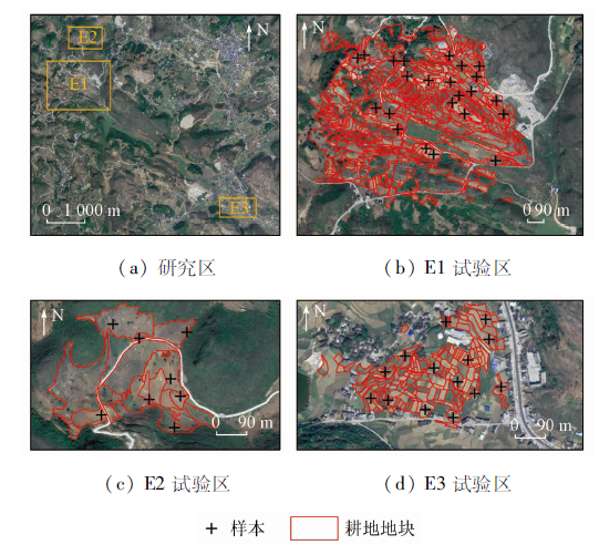
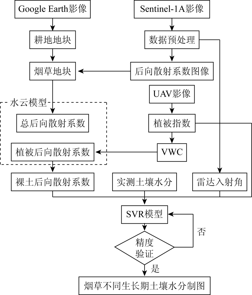
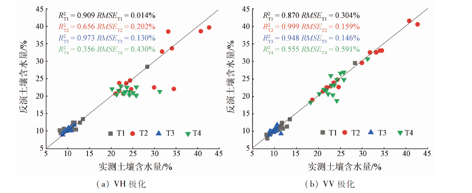
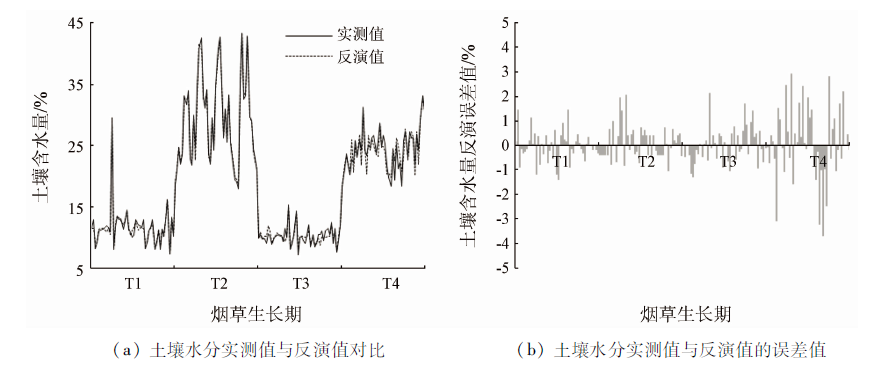
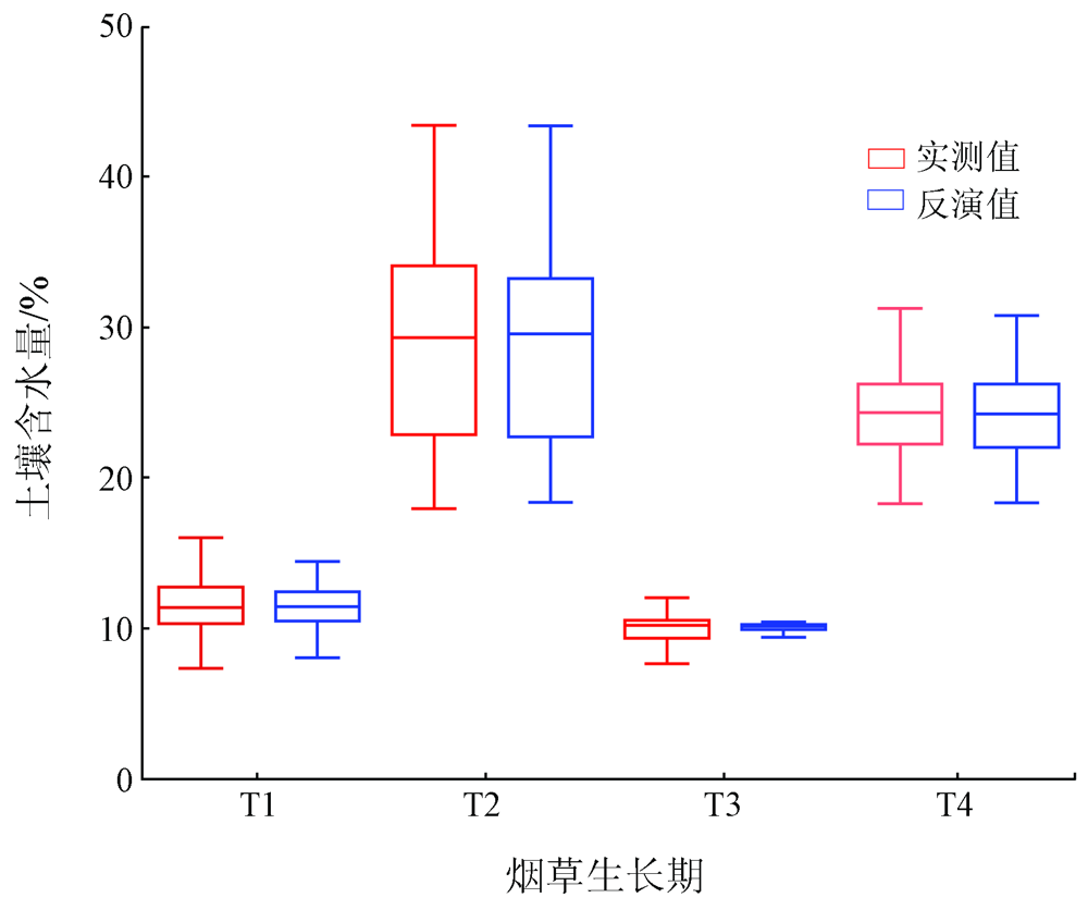
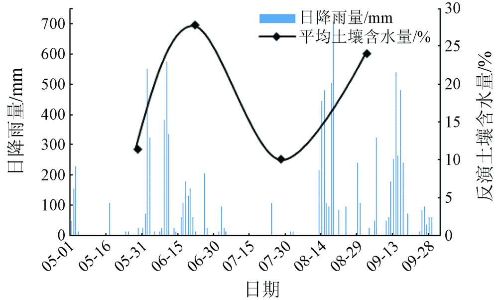
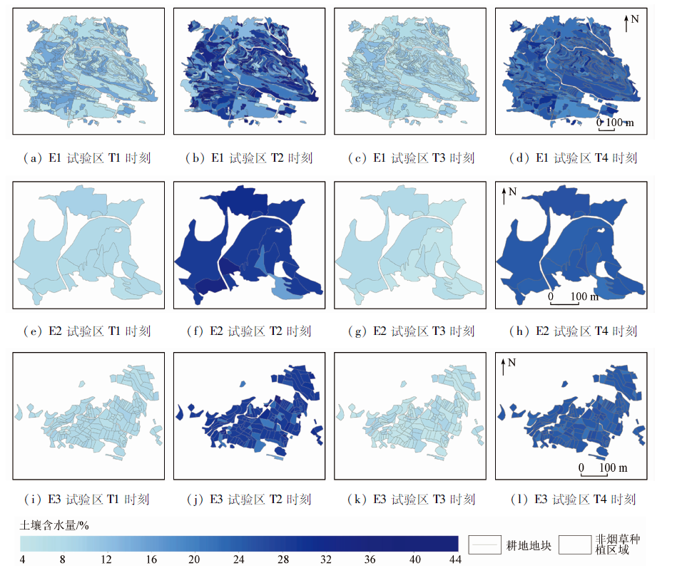
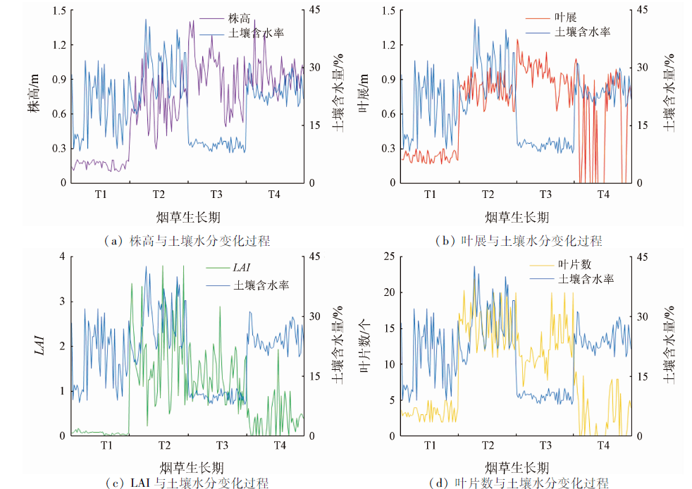
Abstract The farmland’s soil moisture plays an important role in crop yield estimation and drought monitoring and is also a key parameter for fine-scale monitoring of farmland in karst mountainous areas. Targeting the complex environmental impacts in karst regions such as farmland fragmentation and the fact that the inversion of soil moisture is vulnerable to cloud interference, this study employed both the water cloud model (WCM) and the support vector regression (SVR) model to conduct the block-scale inversion of the soil moisture in the growth periods of tobacco using the multi-temporal Sentinel-1 synthetic aperture Radar (SAR) images and the unmanned aerial vehicle (UAV) RGB images. The results are as follows. ① In this study, conventional vegetation parameters were replaced with the visible-band difference vegetation index (VDVI), which combined with its water cloud model was highly applicable to karst mountainous areas. The co-polarization method yielded higher inversion precision, with a coefficient of determination of 0.843 and RMSE of 0.983%. These provide a convenient method for the inversion of farmland’s soil moisture in cloudy and rainy mountainous areas. ② The trend of soil moisture in the four growth periods of tobacco is consistent with that of precipitation. Farmland with rocky desertification has low soil moisture, which is closely related to the bare rocks, complex terrain, and difficulties with irrigation in the experimental area. ③ Soil moisture has significant effects on tobacco growth. Specifically, high soil moisture promotes tobacco growth and low soil moisture inhibits tobacco growth, especially during T1—T3. This study can be utilized as a reference for the fine-scale inversion of the farmland’s soil moisture in cloudy and rainy mountainous areas.
|
| Keywords
soil moisture
farmland parcel
water cloud model
SAR
Sentinel-1
UAV remote sensing
tobacco growth period
|
|
|
|
Corresponding Authors:
ZHOU Zhongfa
E-mail: zhangshu260@163.com;fa6897@163.com
|
|
Issue Date: 21 September 2022
|
|
|
| [1] |
Anagnostopoulos V, Petropoulos G P, Ireland G, et al. A modernized version of a 1D soil vegetation atmosphere transfer model for improving its future use in land surface interactions studies[J]. Environmental Modelling and Software, 2017(90):147-156.
|
| [2] |
Bolten J D, Crow W T, Zhan X, et al. Evaluating the utility of remotely sensed soil moisture retrievals for operational agricultural drought monitoring[J]. IEEE Journal of Selected Topics in Applied Earth Observations and Remote Sensing, 2010, 3(1):57-66.
doi: 10.1109/JSTARS.2009.2037163
url: https://ieeexplore.ieee.org/document/5353747/
|
| [3] |
Mccoll K A, Alemohammad S H, Akbar R, et al. The global distribution and dynamics of surface soil moisture[J]. Nature Geoence, 2017, 10(2):100-104.
|
| [4] |
罗占春, 杜伟, 张卫星. 土壤水分与烟草生长发育和生理代谢的相关研究进展[J]. 山地农业生物学报, 2009, 28(5):446-451.
|
| [4] |
Luo Z C, Du W, Zhang W X. The progress on the effect of soil water on growth and development and physiological metabolism of Tobacco[J]. Journal of Mountain Agriculture and Biology, 2009, 28(5):446-451.
|
| [5] |
Al Y A, Wigneron J P, Ducharne A, et al. Global-scale evaluation of two satellite-based passive microwave soil moisture datasets (SMOS and AMSR-E) with respect to land data assimilation system estimates[J]. Remote Sensing of Environment, 2014, 149(1): 181-195.
doi: 10.1016/j.rse.2014.04.006
url: https://linkinghub.elsevier.com/retrieve/pii/S0034425714001448
|
| [6] |
Hajnsek I, Jagdhuber T, Schcoen H, et al. Potential of estimating soil moisture under vegetation cover by means of PolSAR[J]. IEEE Transactions on Geoscience and Remote Sensing, 2009, 47(2): 442-454.
doi: 10.1109/TGRS.2008.2009642
url: http://ieeexplore.ieee.org/document/4773468/
|
| [7] |
Trudel M, Charbonneau F, Leconte R. Using RADARSAT-2 polarimetric and ENVISAT-ASAR dual-polarization data for estimating soil moisture over agricultural fields[J]. Canadian Journal of Remote Sensing, 2012, 38(4): 514-527.
|
| [8] |
Ulaby F T, Sarabandl K, Mcdonald K. Michigan microwave canopy scattering model[J]. International Journal of Remote Sensing, 1990, 11(7):1223-1253.
doi: 10.1080/01431169008955090
url: https://www.tandfonline.com/doi/full/10.1080/01431169008955090
|
| [9] |
Joseph A T, Van d V R, O’Neill P E, et al. Soil moisture retrieval during a corn growth cycle using L-cand (1.6 GHz) Radar observations[J]. IEEE Transactions on Geoscience and Remote Sensing, 2008, 46(8): 2365-2374.
doi: 10.1109/TGRS.2008.917214
url: http://ieeexplore.ieee.org/document/4578823/
|
| [10] |
De Roo R D, Du Y, Ulaby F T, et al. A semi-empirical backscattering model at L-band and C-band for a soybean canopy with soil moisture inversion[J]. IEEE Transactions on Geoscience and Remote Sensing, 2001, 39(4): 864-872.
doi: 10.1109/36.917912
url: http://ieeexplore.ieee.org/document/917912/
|
| [11] |
Attema E P W, Ulaby F T. Vegetation modeled as a water cloud[J]. Radio Science, 1978, 13(2):357-364.
doi: 10.1029/RS013i002p00357
url: http://doi.wiley.com/10.1029/RS013i002p00357
|
| [12] |
汪小钦, 王苗苗, 王绍强, 等. 基于可见光波段无人机遥感的植被信息提取[J]. 农业工程学报, 2015, 31(5):152-159.
|
| [12] |
Wang X Q, Wang M M, Wang S Q, et al. Extraction of vegetation information from visible unmanned aerial vehicle images[J]. Transactions of the Chinese Society of Agricultural Engineering, 2015, 31(5):152-159.
|
| [13] |
丁雷龙, 李强子, 杜鑫, 等. 基于无人机图像颜色指数的植被识别[J]. 国土资源遥感, 2016, 28(1):78-86.doi: 10.6046/gtzyyg.2016.01.12.
doi: 10.6046/gtzyyg.2016.01.12
|
| [13] |
Ding L L, Li Q Z, Du X, et al. Vegetation extraction method based on color indices from UAV images[J]. Remote Sensing for Land and Resources, 2016, 28(1):78-86.doi: 10.6046/gtzyyg.2016.01.12.
doi: 10.6046/gtzyyg.2016.01.12
|
| [14] |
朱孟, 周忠发, 蒋翼, 等. 基于可见光波段无人机遥感的火龙果精准识别方法[J]. 激光与光电子学进展, 2020, 57(14):359-368.
|
| [14] |
Zhu M, Zhou Z F, Jiang Y, et al. An accurate recognition method of pitaya plants based on visible light band UAV remote sensing[J]. Laser and Optoelectronics Progress, 2020, 57(14):359-368.
|
| [15] |
李朝阳, 王普, 潘方博. 利用主动微波遥感数据监测土壤墒情方法[J]. 南水北调与水利科技, 2017, 15(2):224-228,253.
|
| [15] |
Li C Y, Wang P, Pan F B. Using active microwave remote sensing data to detect soil moisture[J]. South-to-North Water Transfers and Water Science and Technology, 2017, 15(2):224-228,253.
|
| [16] |
Kim Y, van Zyl J J. A time-series approach to estimate soil moisture using polarimetric Radar data[J]. IEEE Transactions on Geoscience and Remote Sensing, 2009, 47(8):2519-2527.
doi: 10.1109/TGRS.2009.2014944
url: http://ieeexplore.ieee.org/document/4810143/
|
| [17] |
张祥, 陈报章, 赵慧, 等. 基于时序Sentinel-1A数据的农田土壤水分变化检测分析[J]. 遥感技术与应用, 2017, 32(2):338-345.
|
| [17] |
Zhang X, Chen B Z, Zhao H, et al. Soil moisture change detection over bare agricultural area by means of time-series Sentinel-1A SAR data[J]. Remote Sensing Technology and Application, 2017, 32(2):338-345.
|
| [18] |
姜红, 玉素甫江·如素力, 拜合提尼沙·阿不都克日木, 等. 基于支持向量机回归算法的土壤水分光学与微波遥感协同反演[J]. 地理与地理信息科学, 2017, 33(6):30-36.
|
| [18] |
Jiang H, Yusufujiang R, Baihetinisha A, et al. Soil moisture retrieval by synergizing optical and microwave remote sensing data based on support vector machine regression algorithm[J]. Geography and Geo-Information Science, 2017, 33(6):30-36.
|
| [19] |
杨贵军, 岳继博, 李长春, 等. 基于改进水云模型和Radarsat-2数据的农田土壤含水量估算[J]. 农业工程学报, 2016, 32(22):146-153.
|
| [19] |
Yang G J, Yue J B, Li C C, et al. Estimation of soil moisture in farmland using improved water cloud model and Radarsat-2 data[J]. Transactions of the Chinese Society of Agricultural Engineering, 2016, 32(22):146-153.
|
| [20] |
郭交, 刘健, 宁纪锋, 等. 基于Sentinel多源数据的农田地表土壤水分反演模型构建与验证[J]. 农业工程学报, 2019, 35(14):71-78.
|
| [20] |
Guo J, Liu J, Ning J F, et al. Construction and validation of soil moisture retrieval model in farmland based on Sentinel multi-source data[J]. Transactions of the Chinese Society of Agricultural Engineering, 2019, 35(14):71-78.
|
| [21] |
黄启厅, 曾志康, 谢国雪, 等. 基于高时空分辨率遥感数据协同的作物种植结构调查[J]. 南方农业学报, 2017, 48(3):552-560.
|
| [21] |
Huang Q T, Zeng Z K, Xie G X, et al. Investigation on crop planting structure based on synergy of high spatial-temporal resolution remote sensing data[J]. Journal of Southern Agriculture, 2017, 48(3):552-560.
|
| [22] |
赵馨, 周忠发, 王玲玉, 等. 喀斯特山区石漠化耕地遥感精准提取与分析——以贵州省北盘江镇与花江镇为例[J]. 热带地理, 2020, 40(2):289-302.
doi: 10.13284/j.cnki.rddl.003233
|
| [22] |
Zhao X, Zhou Z F, Wang L Y, et al. Extraction and analysis of cultivated land experiencing rocky desertification in Karst mountain areas based on remote sensing:A case study of Beipanjiang Town and Huajiang Town in Guizhou Province[J]. Tropical Geography, 2020, 40 (2):289-302.
doi: 10.13284/j.cnki.rddl.003233
|
| [23] |
王玲玉, 陈全, 吴跃, 等. 基于地块级时序NDVI的喀斯特山区撂荒地特征精准识别[J]. 国土资源遥感, 2020, 32(3):23-31.doi: 10.6046/gtzyyg.2020.03.04.
doi: 10.6046/gtzyyg.2020.03.04
|
| [23] |
Wang L Y, Chen Q, Wu Y, et al. Accurate recognition and extraction of Karst abandoned land features based on cultivated land parcels and time series NDVI[J]. Remote Sensing for Land and Resources, 2020, 32(3):23-31.doi: 10.6046/gtzyyg.2020.03.04.
doi: 10.6046/gtzyyg.2020.03.04
|
| [24] |
刘巍, 吴志峰, 骆剑承, 等. 深度学习支持下的丘陵山区耕地高分辨率遥感信息分区分层提取方法[J]. 测绘学报, 2021, 50(1):105-116.
|
| [24] |
Liu W, Wu Z F, Luo J C, et al. A divided and stratified extraction method of high-resolution remote sensing information for cropland in hilly and mountainous areas based on deep learning[J]. Acta Geodaetica et Cartographica Sinica, 2021, 50(1):105-116.
|
| [25] |
Bindlish R, Barros A P. Parameterization of vegetation backscatter in Radar-based,soil moisture estimation[J]. Remote Sensing of Environment, 2001, 76(1):130-137.
doi: 10.1016/S0034-4257(00)00200-5
url: https://linkinghub.elsevier.com/retrieve/pii/S0034425700002005
|
| [26] |
Jackson T J, Schmugge T J. Vegetation effects on the microwave emission of soils[J]. Remote Sensing of Environment, 1991, 36(3): 203-212.
doi: 10.1016/0034-4257(91)90057-D
url: https://linkinghub.elsevier.com/retrieve/pii/003442579190057D
|
| [27] |
刘万侠, 王娟, 刘凯, 等. 植被覆盖地表主动微波遥感反演土壤水分算法研究[J]. 热带地理, 2007(5):411-415,450.
|
| [27] |
Liu W X, Wang J, Liu K, et al. Soil moisture data retrieval by active microwave remote sensing on vegetative land[J]. Tropical geo-graphy, 2007(5):411-415,450.
|
| [28] |
陈全, 周忠发, 王玲玉, 等. 基于多时相Sentinel-1 SAR数据的喀斯特石漠化区地表土壤水分反演研究[J]. 红外与毫米波学报, 2020, 39(5):626-634.
|
| [28] |
Chen Q, Zhou Z F, Wang L Y, et al. Surface soil moisture retrieval using multi-temporal Sentinel-1 SAR data in Karst rocky desertification area[J]. Journal of Infrared and Millimeter Waves, 2020, 39(5):626-634.
|
|
Viewed |
|
|
|
Full text
|
|
|
|
|
Abstract
|
|
|
|
|
Cited |
|
|
|
|
| |
Shared |
|
|
|
|
| |
Discussed |
|
|
|
|
 2022,
Vol. 34
2022,
Vol. 34