|
|
 |
|

|
|
|
Analysis of the groundwater storage variations and their driving factors in the three eastern coastal urban agglomerations of China |
LIN Xuemin1,2( ), LI Weifeng2(), WANG Hong3, MING Dongping1, HAN Lijian2 ), LI Weifeng2(), WANG Hong3, MING Dongping1, HAN Lijian2 |
1. School of Information Engineering and Technology, China University of Geosciences (Beijing), Beijing 100083, China
2. Research Center for Eco-Environmental Sciences, Chinese Academy of Sciences, Beijing 100085, China
3. Information Center of Ministry of Natural Resources, Beijing 100036, China |
|
|
|
|
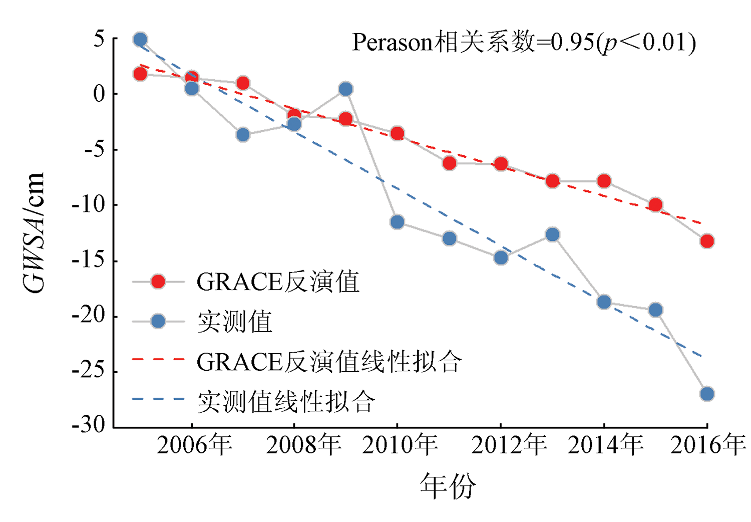
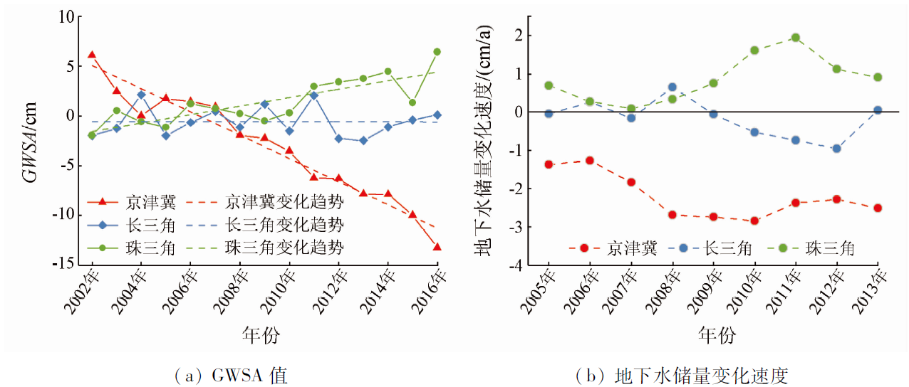
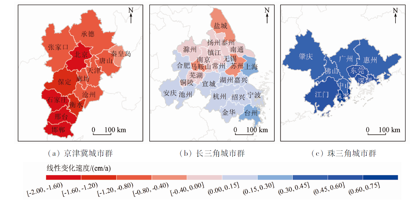
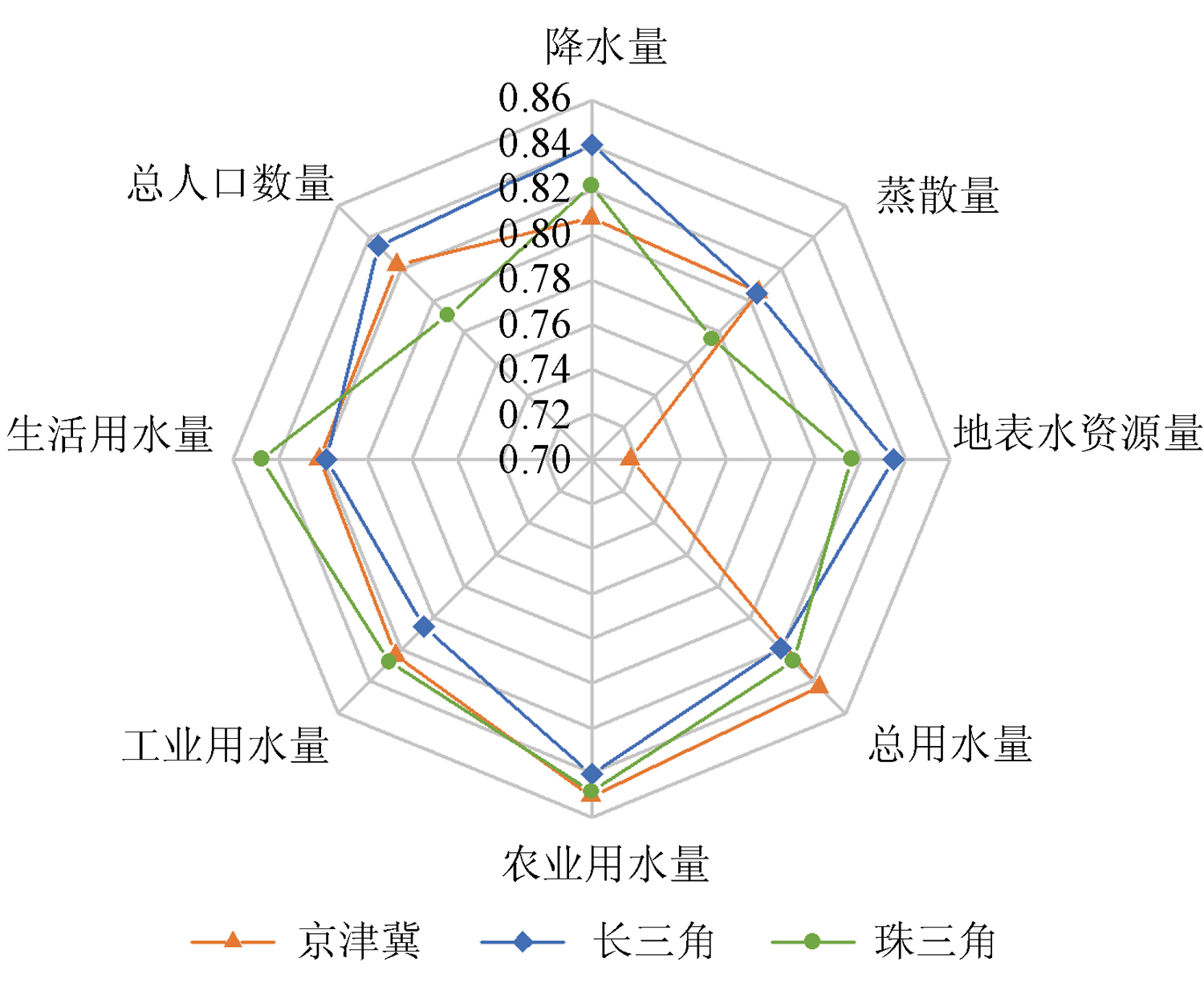
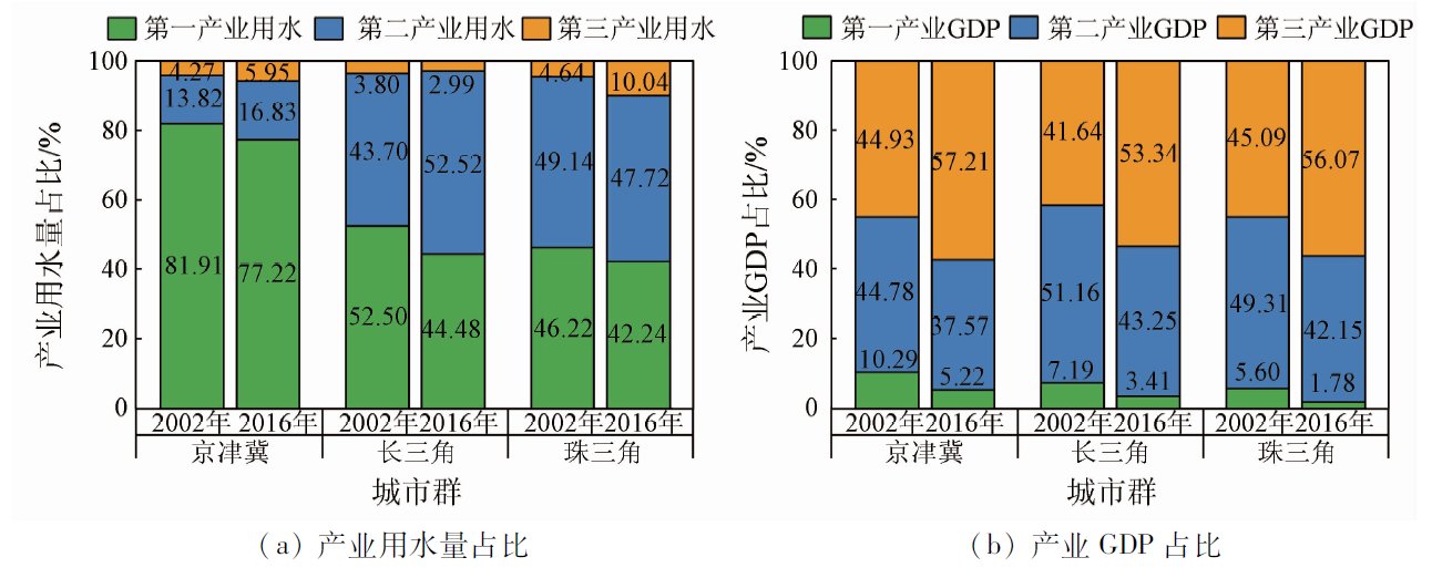
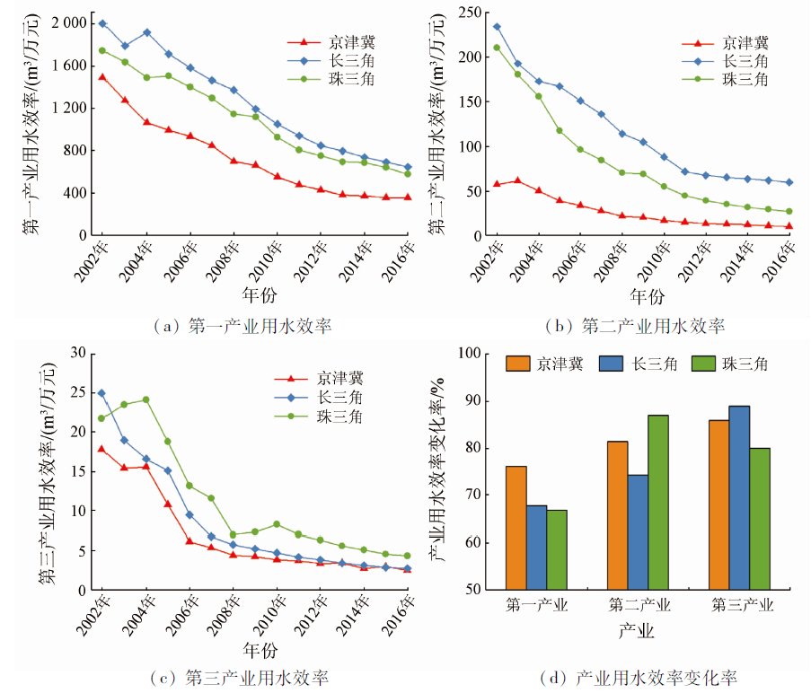
Abstract A series of geological disasters caused by groundwater overexploitation has severely restricted the sustainable development of the three eastern coastal urban agglomerations in China: Beijing-Tianjin-Hebei (BTH), Yangtze River Delta (YRD), and Pearl River Delta (PRD). To reveal the spatial-temporal dynamic variations and their driving factors of groundwater storage (GWS) in the three urban agglomerations, this study quantitatively inverted the GWS variations in the three urban agglomerations during 2002—2016 using the Gravity Recovery and Climate Experiment (GRACE) satellite data. Then, attribution analysis was made using the gray relational analysis method. The results are as follows. The GWS kept decreasing at a linear rate of 1.17 cm/a in BTH, was relatively stable with slight fluctuation in YRD, and continued to increase at a linear rate of 0.43 cm/a in PRD. The GWS variations in the three urban agglomerations were all dominated by anthropogenic factors. The BTH was significantly affected by agricultural water consumption; the YRD was affected by agricultural water consumption, precipitation, surface water availability, and population; the PRD was significantly affected by both agricultural and domestic water consumption. According to the comparative analysis of the GWS variations and their driving factors among the three urban agglomerations, the development of urban agglomerations promoted industrial restructuring and upgrades the secondary and tertiary industries, with water utilization efficiency and structure improved, thus playing a positive role in groundwater protection. Considering the natural resource capacity and development patterns of the eastern coastal urban agglomerations, the key to GWS protection and restoration is to scientifically plan agricultural development and further optimize industrial structure so as to improve water utilization efficiency and prevent surface water pollution.
|
| Keywords
groundwater storage
groundwater utilization
urban agglomeration
GRACE
driving factor
|
|
|
|
Issue Date: 27 December 2022
|
|
|
| [1] |
Jakeman A J, Barreteau O, Hunt R J, et al. Integrated groundwater management:An overview of concepts and challenges[M]// JakemanA J, BarreteauO, HuntR J, et al. Integrated groundwater management:Concepts,approaches and challenges. Cham: Springer International Publishing, 2016:3-20.
|
| [2] |
Jin S, Feng G. Large-scale variations of global groundwater from satellite gravimetry and hydrological models,2002—2012[J]. Global and Planetary Change, 2013, 106:20-30.
doi: 10.1016/j.gloplacha.2013.02.008
url: https://linkinghub.elsevier.com/retrieve/pii/S0921818113000416
|
| [3] |
Ye S, Xue Y, Wu J, et al. Progression and mitigation of land subsidence in China[J]. Hydrogeology Journal, 2016, 24(3):685-693.
doi: 10.1007/s10040-015-1356-9
url: http://link.springer.com/10.1007/s10040-015-1356-9
|
| [4] |
Dong S, Samsonov S, Yin H, et al. Time-series analysis of subsidence associated with rapid urbanization in Shanghai,China measured with SBAS InSAR method[J]. Environmental Earth Sciences, 2014, 72(3):677-691.
doi: 10.1007/s12665-013-2990-y
url: http://link.springer.com/10.1007/s12665-013-2990-y
|
| [5] |
Brunori C, Bignami C, Albano M, et al. Land subsidence,ground fissures and buried faults:InSAR monitoring of Ciudad Guzmán(Jalisco,Mexico)[J]. Remote Sensing, 2015, 7(7):8610-8630.
doi: 10.3390/rs70708610
url: http://www.mdpi.com/2072-4292/7/7/8610
|
| [6] |
郭坤一, 于军, 方正, 等. 长江三角洲地区地下水资源与地质灾害调查评价[C]// “十五”重要地质科技成果暨重大找矿成果交流会材料二——“十五”地质行业获奖成果资料汇编. 北京: [s.n.], 2006:142-143.
|
| [6] |
Guo K Y, Yu J, Fang Z, et al. Investigation and evaluation of groundwater resources and geological hazards in the Yangtze River Delta Region[C]// “Tenth Five-Year Plan” Important Geological Science and Technology Achievements and Major Prospecting Achievements Exchange Meeting Material II: “Tenth Five-Year Plan ” Geological Industry Award-Winning Achievements Data Compilation. Beijing:[s.n.], 2006:142-143.
|
| [7] |
喻永平, 林鸿, 王会强. 利用时序InSAR技术监测广花盆地地面沉降[J]. 测绘通报, 2015(1):157-159.
|
| [7] |
Yu Y P, Lin H, Wang H Q. Using time series InSAR technology to monitor land subsidence in Guanghua Basin[J]. Bulletin of Surveying and Mapping, 2015(1):157-159.
|
| [8] |
Conway B D. Land subsidence and earth fissures in south-central and southern Arizona,USA[J]. Hydrogeology Journal, 2016, 24(3):649-655.
doi: 10.1007/s10040-015-1329-z
url: http://link.springer.com/10.1007/s10040-015-1329-z
|
| [9] |
高茂生, 骆永明. 我国重点海岸带地下水资源问题与海水入侵防控[J]. 中国科学院院刊, 2016, 31(10):1197-1203.
|
| [9] |
Gao M S, Luo Y M. Change of groundwater resource and prevention and control of seawater intrusion in coastal zone[J]. Bulletin of Chinese Academy of Sciences, 2016, 31(10):1197-1203.
|
| [10] |
Chen J, Famigliett J S, Scanlon B R, et al. Groundwater storage changes:Present status from GRACE observations[J]. Surveys in Geophysics, 2016, 37(2):397-417.
doi: 10.1007/s10712-015-9332-4
url: http://link.springer.com/10.1007/s10712-015-9332-4
|
| [11] |
Yin W, Hu L, Zhang M, et al. Statistical downscaling of GRACE-derived groundwater storage using ET data in the North China Plain[J]. Journal of Geophysical Research:Atmospheres, 2018, 123(11):5973-5987.
doi: 10.1029/2017JD027468
url: http://doi.wiley.com/10.1029/2017JD027468
|
| [12] |
Long D, Yang W, Scanlon B R, et al. South-to-North Water Diversion stabilizing Beijing’s groundwater levels[J]. Nature Communications, 2020, 11(1):3665.
doi: 10.1038/s41467-020-17428-6
pmid: 32694568
|
| [13] |
Frappart F, Ramillien G. Monitoring groundwater storage changes using the gravity recovery and climate experiment(GRACE) satellite mission:A review[J]. Remote Sensing, 2018, 10(6):829.
doi: 10.3390/rs10060829
url: http://www.mdpi.com/2072-4292/10/6/829
|
| [14] |
Gong H, Pan Y, Zheng L, et al. Long-term groundwater storage changes and land subsidence development in the North China Plain(1971—2015)[J]. Hydrogeology Journal, 2018, 26(5):1417-1427.
doi: 10.1007/s10040-018-1768-4
url: https://doi.org/10.1007/s10040-018-1768-4
|
| [15] |
Kalhor K, Emaminejad N. Sustainable development in cities:Studying the relationship between groundwater level and urbanization using remote sensing data[J]. Groundwater for Sustainable Develo-pment, 2019, 9:100243.
|
| [16] |
Gao F, Wang H, Liu C. Long-term assessment of groundwater resources carrying capacity using GRACE data and Budyko model[J]. Journal of Hydrology, 2020, 588:125042.
doi: 10.1016/j.jhydrol.2020.125042
url: https://linkinghub.elsevier.com/retrieve/pii/S0022169420305023
|
| [17] |
Hua S, Jing H, Yao Y, et al. Can groundwater be protected from the pressure of China’s urban growth?[J]. Environment International, 2020, 143:105911.
doi: 10.1016/j.envint.2020.105911
url: https://linkinghub.elsevier.com/retrieve/pii/S0160412020318663
|
| [18] |
Yar P. Urban development and its impact on the depletion of groundwater aquifers in Mardan City,Pakistan[J]. Groundwater for Sustainable Development, 2020, 11:100426.
doi: 10.1016/j.gsd.2020.100426
url: https://linkinghub.elsevier.com/retrieve/pii/S2352801X20300850
|
| [19] |
Nath B, Ni-Meister W, Choudhury R. Impact of urbanization on land use and land cover change in Guwahati City,India and its implication on declining groundwater level[J]. Groundwater for Sustainable Development, 2021, 12:100500.
doi: 10.1016/j.gsd.2020.100500
url: https://linkinghub.elsevier.com/retrieve/pii/S2352801X20305129
|
| [20] |
Odeh T, Mohammad A H, Hussein H, et al. Over-pumping of groundwater in Irbid governorate,northern Jordan:A conceptual model to analyze the effects of urbanization and agricultural activities on groundwater levels and salinity[J]. Environmental Earth Sciences, 2019, 78(1):40.
doi: 10.1007/s12665-018-8031-0
url: https://doi.org/10.1007/s12665-018-8031-0
|
| [21] |
李文鹏, 王龙凤, 郭海朋, 等. 中国地面沉降防治成效与对策建议[J]. 中国水利, 2021(7):32-35.
|
| [21] |
Li W P, Wang L F, Guo H P, et al. Effectiveness and countermeasures of land subsidence control in China[J]. China Water Resources, 2021(7):32-35.
|
| [22] |
陈慧川. 珠江三角洲地区地下水开发利用现状分析与建议[J]. 地下水, 2011, 33(2):38-40.
|
| [22] |
Chen H C. Analysis and suggestions on the current situation of groundwater development and utilization in the Pearl River Delta[J]. Groundwater, 2011, 33(2):38-40.
|
| [23] |
Long D, Yang Y, Wada Y, et al. Deriving scaling factors using a global hydrological model to restore GRACE total water storage changes for China’s Yangtze River Basin[J]. Remote Sensing of Environment, 2015, 168:177-193.
doi: 10.1016/j.rse.2015.07.003
url: https://linkinghub.elsevier.com/retrieve/pii/S0034425715300602
|
| [24] |
赵玉峰, 罗专溪, 于亚军, 等. 京津冀西北典型区域地下水位时空演变及驱动因素[J]. 自然资源学报, 2020, 35(6):1301-1313.
|
| [24] |
Zhao Y F, Luo Z X, Yu Y J, et al. Spatio-temporal changes of groundwater level and its driving factors in a typical region of Beijing-Tianjin-Hebei region,China[J]. Journal of Natural Resources, 2020, 35(6):1301-1313.
doi: 10.31497/zrzyxb.20200604
url: http://www.jnr.ac.cn/EN/10.31497/zrzyxb.20200604
|
| [25] |
刘洋, 李丽娟. 京津冀地区产业结构和用水结构变动关系[J]. 南水北调与水利科技, 2019, 17(2):1-9.
|
| [25] |
Liu Y, Li L J. The relationship between industrial structure and water consumption structure in Beijing-Tianjin-Hebei region[J]. South-to-North Water Transfers and Water Science and Technology, 2019, 17(2):1-9.
|
| [26] |
Huang Z, Tang Q, Lo M H, et al. The influence of groundwater representation on hydrological simulation and its assessment using satellite-based water storage variation[J]. Hydrological Processes, 2019, 33(8):1218-1230.
doi: 10.1002/hyp.13393
url: https://onlinelibrary.wiley.com/doi/10.1002/hyp.13393
|
| [27] |
Long D, Longuevergne L, Scanlon B R. Uncertainty in evapotranspiration from land surface modeling,remote sensing,and GRACE satellites[J]. Water Resources Research, 2014, 50(2):1131-1151.
doi: 10.1002/2013WR014581
url: http://doi.wiley.com/10.1002/2013WR014581
|
| [28] |
周磊, 武建军, 吕爱峰, 等. 华北不同地表覆盖类型区干旱演变特征[J]. 地理研究, 2012, 31(4):597-607.
|
| [28] |
Zhou L, Wu J J, Lyu A F, et al. Drought evolution of different land cover regions in North China[J]. Geographical Research, 2012, 31(4):597-607.
doi: 10.11821/yj2012040003
|
| [29] |
裴益轩, 郭民. 滑动平均法的基本原理及应用[J]. 火炮发射与控制学报, 2001, 22(1):21-23.
|
| [29] |
Pei Y X, Guo M. The fundamental principle and application of sliding average method[J]. Gun Launch and Control Journal, 2001, 22(1):21-23.
|
| [30] |
Wang Z, Li J, Liu J, et al. Is the photovoltaic poverty alleviation project the best way for the poor to escape poverty?A DEA and GRA analysis of different projects in rural China[J]. Energy Policy, 2020, 137:111105.
doi: 10.1016/j.enpol.2019.111105
url: https://linkinghub.elsevier.com/retrieve/pii/S0301421519306925
|
| [31] |
Chen X, Jiang J, Lei T, et al. GRACE satellite monitoring and driving factors analysis of groundwater storage under high-intensity coal mining conditions:A case study of Ordos,northern Shaanxi and Shanxi,China[J]. Hydrogeology Journal, 2020, 28(2):673-686.
doi: 10.1007/s10040-019-02101-0
url: https://doi.org/10.1007/s10040-019-02101-0
|
| [32] |
Reddy J J, Varaprasad B J S, Reddy P V. Multi-objective optimization of erosion parameters of erodible soils using Taguchi-based gray relation analysis[J]. Arabian Journal of Geosciences, 2021, 14(17):1723.
doi: 10.1007/s12517-021-08192-y
url: https://doi.org/10.1007/s12517-021-08192-y
|
| [33] |
Mo H. Comprehensive evaluation of flood and flood in the Yellow River Basin based on gray correlation analysis[J]. Journal of Geoscience and Environment Protection, 2021, 9:13-24.
doi: 10.4236/gep.2021.91002
url: https://www.scirp.org/journal/doi.aspx?doi=10.4236/gep.2021.91002
|
| [34] |
霍思远, 靳孟贵. 不同降水及灌溉条件下的地下水入渗补给规律[J]. 水文地质工程地质, 2015, 42(5):6-13,21.
|
| [34] |
Huo S Y, Jin M G. Effects of precipitation and irrigation on vertical groundwater recharge[J]. Hydrogeology and Engineering Geology, 2015, 42(5):6-13,21.
|
| [35] |
柯志庭. 广花盆地地下水位动态与降雨入渗补给研究[D]. 广州: 中山大学, 2013.
|
| [35] |
Ke Z T. Research on groundwater level dynamics and rainfall infiltration replenishment in Guanghua Basin[D]. Guangzhou: Sun Yat-sen University, 2013.
|
| [36] |
王英虎, 郭世娟. 河北省地下水超采综合治理河湖地下水回补试点做法及成[J]. 中国水利, 2020(13):35-36.
|
| [36] |
Wang Y H, Guo S J. Pilot projects for controlling of groundwater over exploitation in Hebei Province by recharging water to aquifers near rivers and lakes[J]. China Water Resources, 2020(13):35-36.
|
| [37] |
位铁强. 聚焦目标任务坚持综合施策全力推进地下水超采综合治理[J]. 河北水利, 2020(11):6-7.
|
| [37] |
Wei T Q. Focus on goals and tasks,adhere to comprehensive measures,and make every effort to promote comprehensive treatment of groundwater overexploitation[J]. Hebei Water Resources, 2020(11):6-7.
|
| [38] |
秦长海, 王亦宁, 邵自平, 等. 国外怎么节约用水[J]. 时事报告, 2021(3):56-57.
|
| [38] |
Qin C H, Wang Y N, Shao Z P, et al. How to save water abroad[J]. Current Affairs Report, 2021(3):56-57.
|
| [39] |
广东省地质环境监测总站. 广东省、香港、澳门特别行政区地下水资源评价报告[R]. 广东: 广东省地质环境监测总站, 2002.
|
| [39] |
Guangdong Provincial Geological Environment Monitoring Station. Evaluation report of groundwater resources in Guangdong Province,Hong Kong and Macao Special Administrative Regions[R]. Guangdong: Guangdong Provincial Geological Environment Monitoring Station, 2002.
|
| [40] |
刘冬. 长三角地区地面沉降[J]. 地球, 2012(1):148-149.
|
| [40] |
Liu D. Land subsidence in the Yangtze River Delta[J]. The Earth, 2012(1):148-149.
|
|
Viewed |
|
|
|
Full text
|
|
|
|
|
Abstract
|
|
|
|
|
Cited |
|
|
|
|
| |
Shared |
|
|
|
|
| |
Discussed |
|
|
|
|
 2022,
Vol. 34
2022,
Vol. 34