|
|
 |
|

|
|
|
Remote sensing-based monitoring of the treatment and redevelopment of the brownfields: A case study of brownfields in the risk control and rehabilitation list of Zhejiang Province |
TONG Jing1( ), YANG Jinzhong1, DU Xin2, DU Xiaomin1, LI Chunbo2, AN Na1 ), YANG Jinzhong1, DU Xin2, DU Xiaomin1, LI Chunbo2, AN Na1 |
1. China Aero Geophysical Survey and Remote Sensing Center for Natural Resources, Beijing 100083, China
2. School of Land Science and Technology, China University of Geosciences(Beijing), Beijing 100083, China |
|
|
|
|
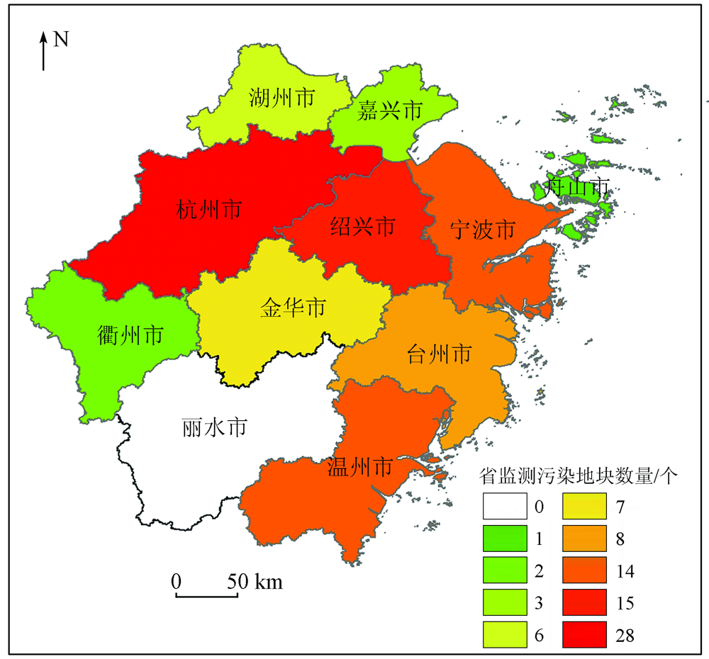
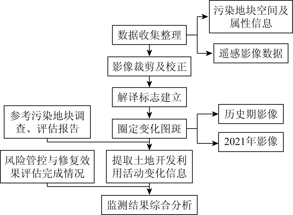
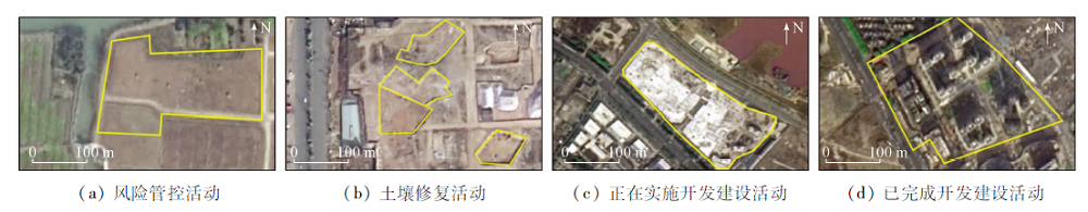
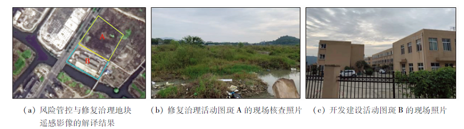
Abstract This study aims to further tap the remote sensing monitoring technique in monitoring the current land use of brownfields, including risk control, soil remediation, and development and construction. Firstly, this study selected 98 brownfields of Zhejiang Province that have been included in the risk control and remediation list in the national contaminated soil information management system. Then, using images of the historical period and the monitoring period from the domestic high-resolution remote sensing satellite, this study conducted the remote sensing monitoring of changes in land use through image processing and human-computer interactive interpretation on the ArcGIS platform. Finally, this study made statistics of the monitoring results by combining the reports on the surveys, risk assessment, and control and remediation effects of the brownfields, as well as the attribute information of the brownfields. The results show that the monitoring based on the remote sensing technique can be used to quickly identify the implementation of risk control, soil remediation, and development and construction of the brownfields and timely grasp the current status, dynamic trends, and issues of the use of brownfields included in the risk control and rehabilitation list. This study will provide technical support and bases for relevant public departments to carry out the access management of the redevelopment of brownfields.
|
| Keywords
brownfield
risk control and remediation
redevelopment
remote sensing monitoring
|
|
|
|
Issue Date: 21 September 2022
|
|
|
| [1] |
金远亮, 侯德义, 田莉, 等. 基于用地规划的污染地块修复多目标优化研究[J]. 中国环境科学, 2021, 41(2):787-800.
|
| [1] |
Jin Y L, Hou D Y, Tian L, et al. Multi-objective optimization for brownfield remediation on the basis of land use planning[J]. China Environmental Science, 2021, 41(2):787-800.
|
| [2] |
Hong Y, Xianjin H, R T J, et al. China’s soil pollution:Urban brownfields[J]. Science(New York), 2014, 344(6185).
|
| [3] |
崔轩, 李志涛, 王夏晖, 等. 污染地块再开发利用准入管理机制探讨[J]. 环境污染与防治, 2019, 41(1):1-5.
|
| [3] |
Cui X, Li Z T, Wang X H, et al. Study on the admittance management mechanism for the redevelopment of contaminated sites[J]. Environmental Pollution & Control, 2019, 41(1):1-5.
|
| [4] |
代秀龙, 林善泉. 城市旧机场地区土地再开发规划策略——以湛江机场片区概念性规划为例[J]. 规划师, 2017, 33(6):94-99.
|
| [4] |
Dai X L, Lin S Q. Old airport land redevelopment planning:A Zhanjiang case[J]. Planners, 2017, 33(6):94-99.
|
| [5] |
付佩, 刘兴姝, 夏莺. 中英棕地治理对土地再开发利用的启示[J]. 西部大开发(土地开发工程研究), 2019, 4(5):57-61.
|
| [5] |
Fu P, Liu X Z, Xia Y. Enlightenment of brownfield management in China and UK on the redevelopment and reuse of land[J]. Land Development and Engineering Research, 2019, 4(5):57-61.
|
| [6] |
李志涛. 不同污染地块,如何选用处置策略?——对几个具体案例的风险管控和治理修复实践分析[J]. 中国生态文明, 2020, 2(3):76-77.
|
| [6] |
Li Z T. How to choose a disposal strategy for different brownfields? ——An analysis of risk management and remediation practices in several specific cases[J]. China’s Ecological Civilization, 2020, 2(3):76-77.
|
| [7] |
孙海波, 谢辉, 陈嘉, 等. 污染土地再开发中的环境风险与责任[J]. 上海国土资源, 2017, 38(1):79-82,86.
|
| [7] |
Sun H T, Xie H, Chen J, et al. Environmental risk and liability of contaminate land redevelopment[J]. Shanghai Land & Resources, 2017, 38(1):79-82,86.
|
| [8] |
吴继业. 工业污染场地再开发利用的思考与建议——以温州市龙湾区为例[J]. 环境保护与循环经济杂志, 2017, 38(1):79-82,86.
|
| [8] |
Wu J Y. Recommendation on the contaminate land redevelopment in Longwan District of Wenzhou City[J]. Liaoning Urban Rural Environ Sci Technol, 2017, 38(1):79-82,86.
|
| [9] |
熊杰. 浅谈工业企业污染地块的修复与再开发[J]. 智能城市, 2019, 5(13):156-157.
|
| [9] |
Xiong J. An introduction to the remediation and redevelopment of contaminated land in industrial enterprises[J]. Intelligent City, 2019, 5(13):156-157.
|
| [10] |
赵沁娜. 城市土地置换过程中土壤污染风险评价与风险管理研究[D]. 上海: 华东师范大学, 2006.
|
| [10] |
Zhao Q N. Study on the risk assessment and risk management of soil pollution during urban band replacement[D]. Shanghai: East China Normal University, 2006.
|
| [11] |
赵沁娜, 范利军. 多元利益视角下的城市“棕色土地”再开发管理[J]. 城市发展研究, 2010, 17(5):98-101.
|
| [11] |
Zhao Q N, Fan L J. Research on the management of urban brownfield’s redevelopment from stakeholders’ perspective[J]. Urban Development Studies, 2010, 17(5):98-101.
|
| [12] |
张俊丽, 王芳, 余勤飞, 等. 工业企业场地再开发的多部门联合监管机制探讨[J]. 环境污染与防治, 2014, 36(12):1-5.
|
| [12] |
Zhang J L, Wang F, Yu Q F, et al. Study on multi-department joint supervision mechanism for redevelopment of industrial contaminated sites[J]. Environmental Pollution & Control, 2014, 36(12):1-5.
|
| [13] |
O’connor D, Hou D. Sustainable remediation and revival of brownfields[J]. Science of the Total Environment, 2020, 741:140475.
doi: 10.1016/j.scitotenv.2020.140475
url: https://linkinghub.elsevier.com/retrieve/pii/S0048969720339978
|
| [14] |
Popescu G, Pătrăşcoiu R. Brownfield sites-between abandonment and redevelopment case study:Craiova City[J]. Human Geographies:Journal of Studies and Research in Human Geography, 2012, 6(1):91-97.
doi: 10.5719/hgeo.2012.61.91
url: http://humangeographies.org.ro/abstracts/61/6111.html
|
| [15] |
Wu Q, Zhang X, Liu C, et al. The de-industrialization,re-suburbanization and health risks of brownfield land reuse:Case study of a toxic soil event in Changzhou,China[J]. Land Use Policy, 2018, 74:187-194.
doi: 10.1016/j.landusepol.2017.07.039
url: https://linkinghub.elsevier.com/retrieve/pii/S0264837717301849
|
| [16] |
王海庆, 武明德, 刘琼, 等. 山西某地矿业开发占用土地状况遥感监测[J]. 国土资源遥感, 2018, 30(1):116-120.doi: 10.6046/gtzyyg.2018.01.16.
doi: 10.6046/gtzyyg.2018.01.16
|
| [16] |
Wang H Q, Wu M D, Liu Q, et al. Remote sensing monitoring of mining land in a certain area of Shanxi Province[J]. Remote Sensing for Land and Resources, 2018, 30(1):116-120.doi: 10.6046/gtzyyg.2018.01.16.
doi: 10.6046/gtzyyg.2018.01.16
|
|
Viewed |
|
|
|
Full text
|
|
|
|
|
Abstract
|
|
|
|
|
Cited |
|
|
|
|
| |
Shared |
|
|
|
|
| |
Discussed |
|
|
|
|
 2022,
Vol. 34
2022,
Vol. 34