Please wait a minute...
 
Remote Sensing for Natural Resources    2023, Vol. 35 Issue (2) : 80-88     DOI: 10.6046/zrzyyg.2022319
|
Key technology for selecting depressions as sites of FAST-type radio telescopes
ZHU Boqin1,2(), YAN Zhaojin3(), XIE Jing3, LIU Hong4, SONG Xiaoqing3, XIANG Xiqiong4
1. National Astronomical Observatory, Chinese Academy of Sciences, Beijing 100101, China
2. Key Laboratory of FAST, Chinese Academy of Sciences, Beijing 100101, China
3. 111 Geological Brigade of Guizhou Provincial Bureau of Geology and Mineral Exploration and Development, Guiyang 550008, China
4. Key Laboratory of Karst Georesources and Environment (Ministry of Education), College of Resources and Environmental Engineering, Guizhou University, Guiyang 550025, China
Download: PDF(4874 KB)   HTML
Export: BibTeX | EndNote | Reference Manager | ProCite | RefWorks    
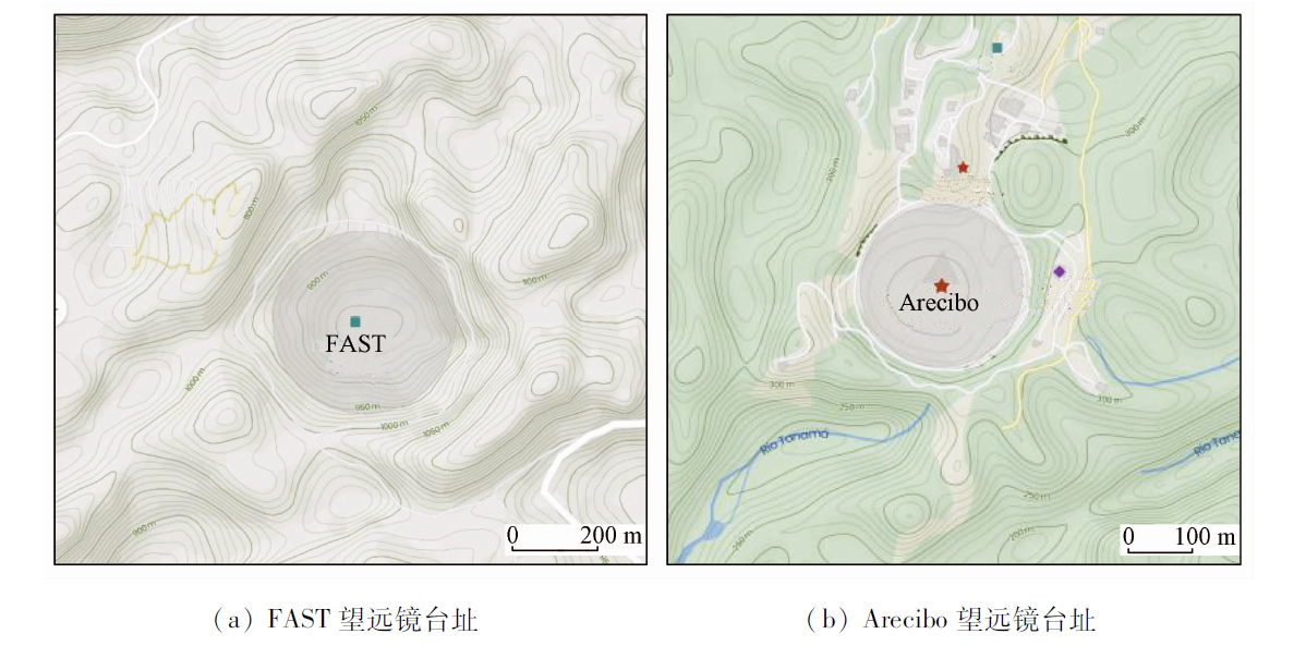
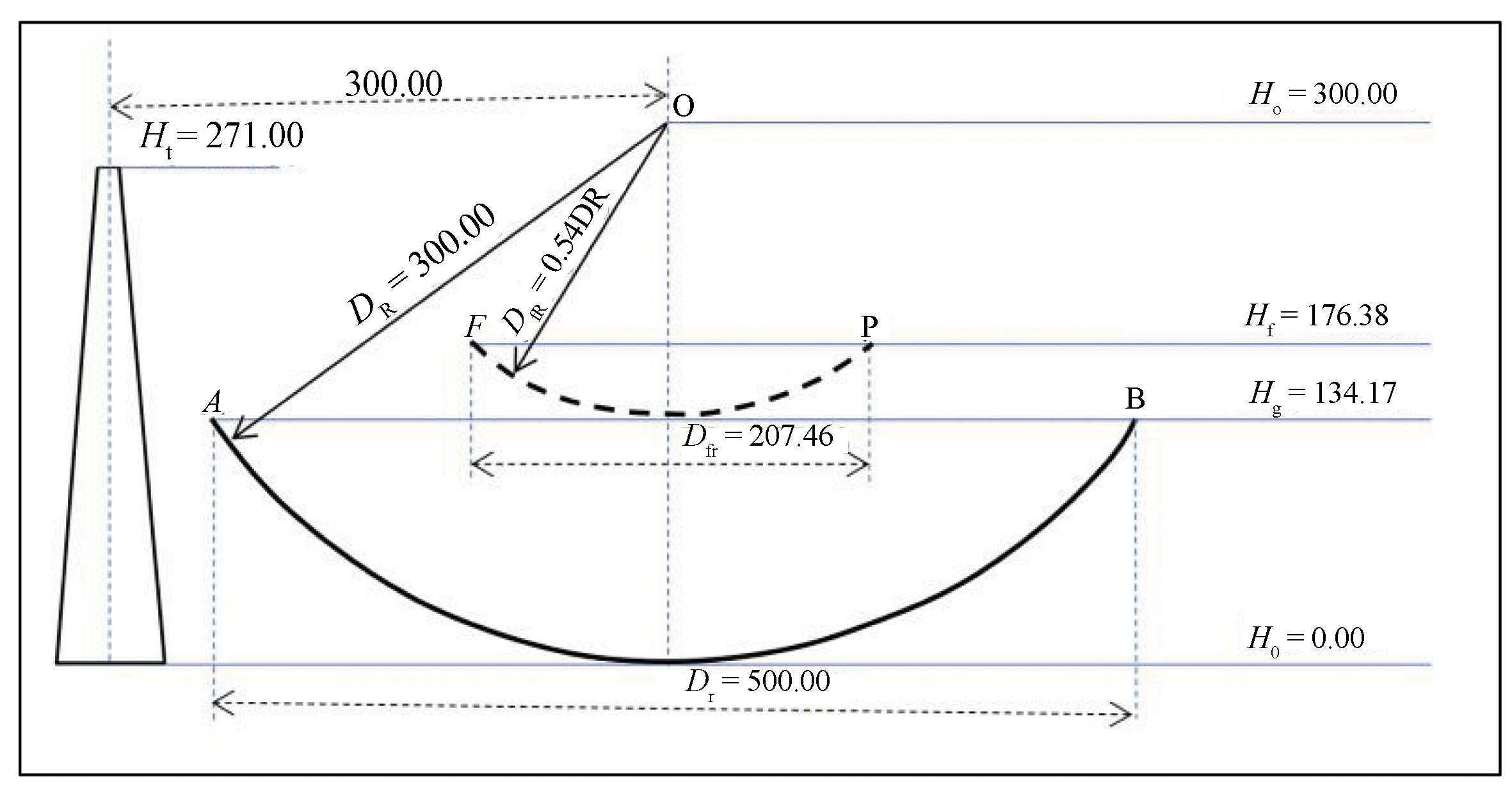
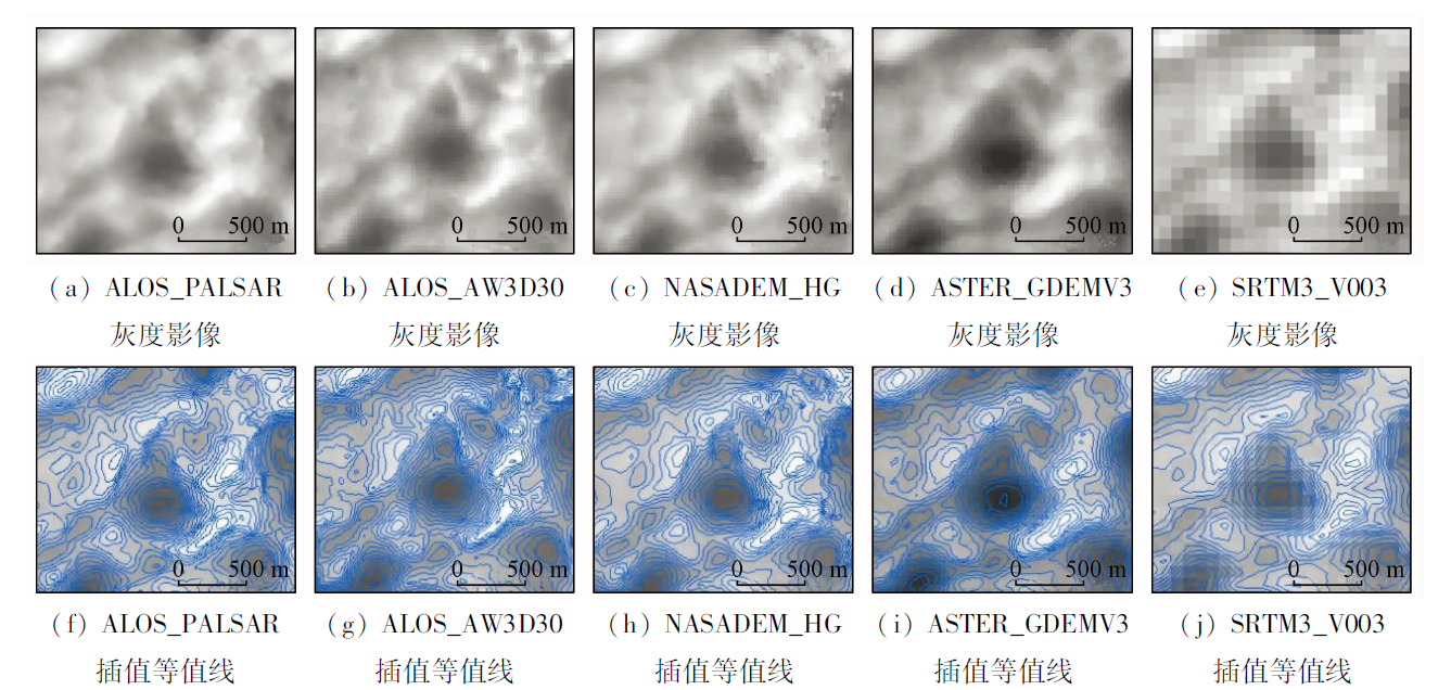
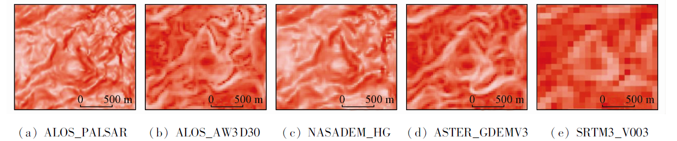
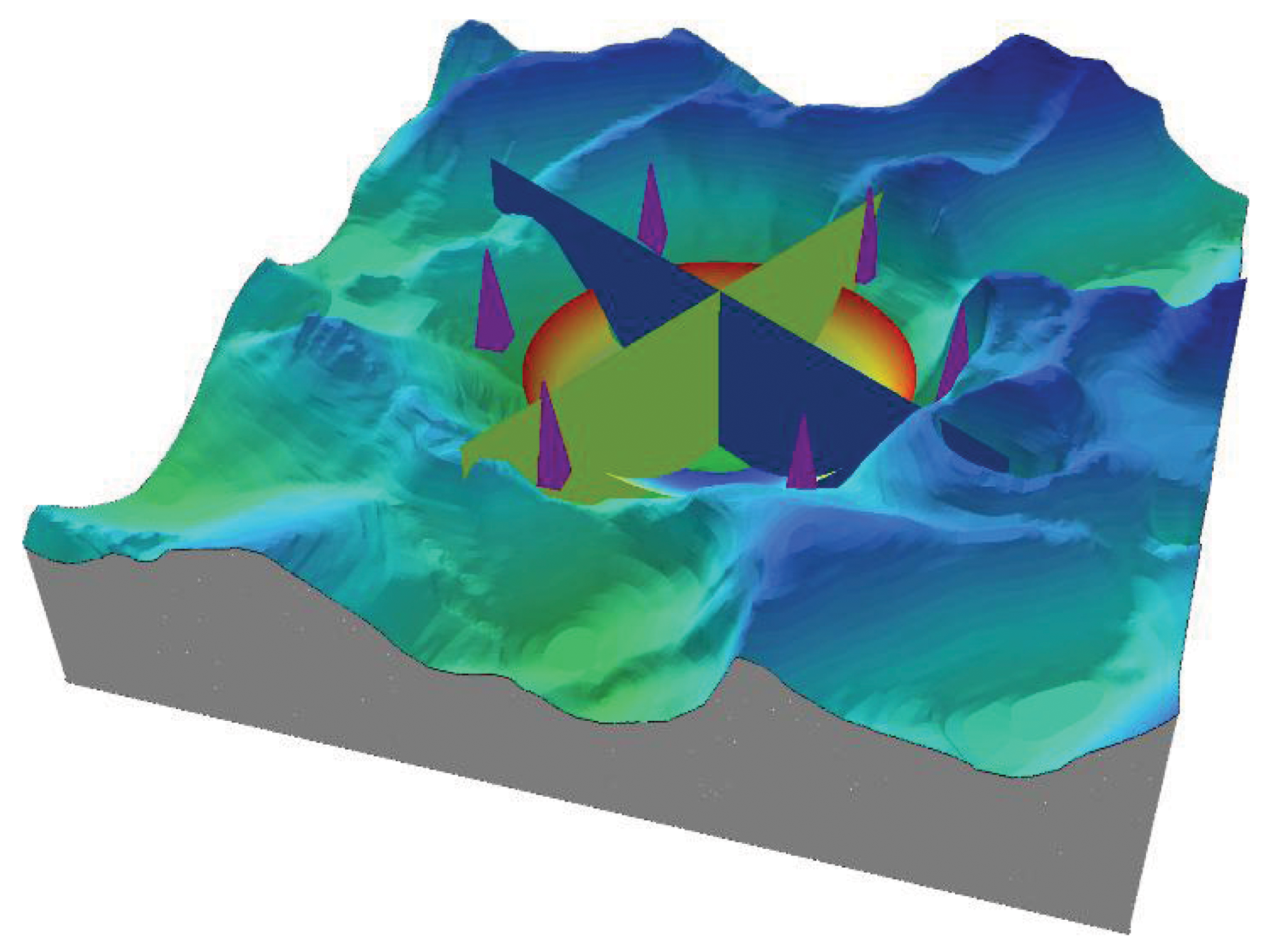
Abstract  

The Five-hundred-meter Aperture Spherical radio Telescope (FAST), also known as Tianyan (meaning the Eye of the Sky), has attracted worldwide attention and is the largest single-dish radio telescope in the world. The joint observations of FAST and several more FAST-type radio telescopes allow detection sensitivity and resolution to be further improved and the research fields to be expanded. Therefore, Chinese radio astronomy scientists have the expectation of building more FAST-type radio telescopes in China, which should be achieved based on the preceding research on depressions as the sites of FAST-type radio telescopes. Presently, the shared digital elevation model (DEM) data enjoy intercontinental coverage and different ground resolutions. The development of computer processing technology has greatly enhanced the processing and analysis capacities of DEM data and continuously innovated the processing technologies. Moreover, relevant analyses and expressions can be simulated. Therefore, based on a comparative analysis of the structural scales of the projects of the Arecibo radio telescope and the FAST, as well as the morphological characteristics of karst depressions, this study proposed the conditions of ideal depressions as the sites of FAST-type radio telescopes. Moreover, by analyzing the resolution and data quality of shared DEM data on the Internet, it is concluded that areas with ASTER_GDEMV3 data with a resolution of 30 m are suitable as sites of large radio telescopes in provincial-level regions. In search of large-scale depressions in Guizhou Province, this study developed special modules for quantitative analyses, such as extracting the characteristic parameters of depressions and the fitting of filling, excavation, and superimposed sections, based on the ArcGIS platform and summarized the key steps to organize and apply the major tools of ArcGIS in the special modules. The results of this study determined key technology in search of large Karst depressions in provincial-level regions. Furthermore, this study proposed several issues that are noteworthy in the application.

Keywords site selection      Karst depression      DEM      terrain parameters      fitting of filling and excavation     
ZTFLH:  TP79  
Issue Date: 07 July 2023
Service
E-mail this article
E-mail Alert
RSS
Articles by authors
Boqin ZHU
Zhaojin YAN
Jing XIE
Hong LIU
Xiaoqing SONG
Xiqiong XIANG
Cite this article:   
Boqin ZHU,Zhaojin YAN,Jing XIE, et al. Key technology for selecting depressions as sites of FAST-type radio telescopes[J]. Remote Sensing for Natural Resources, 2023, 35(2): 80-88.
URL:  
https://www.gtzyyg.com/EN/10.6046/zrzyyg.2022319     OR     https://www.gtzyyg.com/EN/Y2023/V35/I2/80
Fig.1  Site contour map of FAST and Arecibo
几何要素 FAST望远镜 Arecibo望远镜
地理坐标 N25.652°,E106.856° N18.344°,W66.752°
最高山峰标高/m 1 201.2(东北) 360 m(西南)
最低垭口标高/m 981.2(西南) 305 m(南)
原始洼地底标高/m 841.2 235 m
洼地有效深度/m 140 70 m
洼地最大高差/m 360 125 m
周围最低点海拔/m 737.5(东侧水淹凼底) 185 m(南偏东伏流出口)
球直径(开口直径、球冠深)/m 600(500,134.17) 530(305,48.28)
馈源仓悬空/m 176.38 137.25[7]
反射面开口标高/m 970.2 290
基岩类型 三叠纪灰岩、白云质灰岩 中第三纪(即渐新世和中新世)珊瑚礁岩或海滩岩
Tab.1  Comparison of geometric elements of FAST and Arecibo
Fig.2  Geometry sketch of FAST (m)
名称 模型名称 生产技术 发布
单位
水平
精度/m
垂直
精度/m
水平分
辨率/m
水准面 覆盖范围,
发布时间
ALOS_PALSAR DSM ALOS 的 L 波段PALSAR 系统,InSAR 技术并综合 SRTM1 等数据 JAXA,ASF 12.5 12 12.5 WGS84/EGM96 87.8°N~75.9°S,2015年
ALOS_
AW3D30_V2.2
DSM ALOS 的全色遥感立体测绘仪(PRISM)光学立体摄影测量 JAXA EORC 5 5(相当于5 m空间分辨率) 30 WGS84/EGM96 87.8°N~75.9°S, 2019年
NASADEM_
HGTV001
DSM 改善了的 SRTM1 DEM,并应用了了 ASTER GDEM、ICESat GLAS和PRISM等数据 NASA JPL 20 16 30 WGS84/EGM96 60°N~56°S,2020年
ASTER_
GDEMV3
DSM ASTER卫星光学立体摄影测量和数字图像相关方法 NASA、 NIMA 20 17 30 WGS84/EGM96 83°N~83°S,2019年
SRTM3_V003 DSM “奋进”号航天飞机上搭载的 C 波段 SRTM 系统,InSAR 技术 NASA、 NIMA 20 16 90 WGS84/EGM96 60°N~56°S,2014年底
Tab.2  Names of common satellite DEM
Fig.3  DEM gray image and isoline at FAST site
Fig.4  Terrain enhanced image of Dawodang depression(FAST site)
洼地地形参数 地貌特征 DEM数值特征 提取方法
最低点 洼地区域内地形低洼点,是地面水汇流的最低点,坡度为0° 洼地区域内 DEM 数值最小的点 应用移动窗口,求取 DEM 数值最小值(凹陷)及其位置
山峰点 地形突出的高地点,是地面水向四周分散的最高点,坡度为0° 一定区域内 DEM 数值最大的点 应用移动窗口,求取 DEM 数值最大值(凸起)及其位置
垭口点 某一方向地形低洼点和另一方向地形突出高地点,也是分水线与沟谷源头的交叉点,坡度为0° DEM在沟谷方向局部的最大值,同时又是分水线方向最低值的点 提取正地形沟谷线(凹陷)和反地形沟谷线(凹陷)的交汇点
分水线 洼地区域的山梁连线,是地面水向两侧分流点的连线。分水线是封闭、洼地集水汇流边界线,通常称为分水岭 洼地区连续分流点(包括山峰点、垭口点)的连线 判别和提取汇聚最大流量区域的边界
洼地等深线 最低垭口以下洼地深度的等值线,是洼地封闭区域内的深度线。等深线是衡量洼地“有效深度”的地形线,形态上与同一地点的等高线完全一致 DEM 数值均小于最低垭口高度区域的等值线 通过填洼分析得到最低垭口以下部分的栅格数据,再计算与最低垭口之间的高差并等值化
Tab.3  Topographic feature points and its DEM features and extraction methods
洼地地形参数 主要工具和步骤
最低点 ①[焦点统计],应用 MINIMUM 统计类型处理 DEM 数据; ②[栅格计算器],计算输出最低像元(区); ③[栅格转面],栅格低值像元转面型矢量; ④[要素转点],提取低值像元面几何中心点矢量(面内); ⑤[值提取至点],计算矢量点位置的DEM 数值; ⑥编辑整理,删除虚假最低点
山峰点 ①[焦点统计],应用 MAXIMUM 统计类型处理 DEM 数据; ②[栅格计算器],计算输出最高像元(区); ③[栅格转面],栅格高值像元转面型矢量; ④[要素转点],提取高值像元面几何中心点矢量(面内); ⑤[值提取至点],计算矢量点位置的DEM 数值; ⑥编辑整理,删除虚假最高点(山峰点)
垭口点 ①编辑分水线,使得每个洼地分水岭只有一个线矢量记录,即一个洼地的分水线只是一条线,修改矢量线为最北点为起点,顺时针矢量方向; ②[沿线生成分水线洼地等深线点],以一个像素为间隔提取分水线上等间隔顺序点; ③[值提取至点],提取顺序点位置的 DEM 高程值; ④导出包含位置和高程的顺序点数据,应用 EXCEL 对顺序点高程值进行比较判断,即可得到分水线上垭口点(分水线上局部低值)、山峰点(分水线上局部高值); ⑤分类导入,获得分水线上的各个垭口点
分水线 ①[流向],计算 DEM 范围每个像元最大的坡降方位(流向); ②[汇],计算和编号每个没有流向的像元或像元区,也即连续地形中的山峰、垭口、最低点区; ③[集水区],应用流向数据和汇数据,获得最大范围的集水区; ④[分区统计],通过集水区和原始 DEM 数据,选取统计类型 MINIMUM 或 MAXIMUM,即可得到集水区最小 DEM 值或最大高程值作为高程值的栅格; ⑤[栅格转面],将最值栅格转为矢量面; ⑥[消除],设定最小的流域面积和归并方式,消除小多边形; ⑦[要素转线],将流域面多边形转为矢量线; ⑧编辑整理,消除锯齿,删除虚假和不合理矢量线,即可得到完整流域的分水线
洼地等深线 ①[填洼],将一定区域内的 DEM 值修改为最低高程值,使得只有高于这个高程的水才会流出洼地; ②[栅格计算器],计算填洼栅格和原始 DEM 栅格,得到各栅格点的填洼深度; ③[等值线],插值填洼深度值栅格表面,可获得填洼深度等值线,也即最低垭口以下等深度线; ④编辑整理,消除锯齿,删除虚假和不合理等深线
Tab.4  Main tools and steps for modular extraction of terrain parameters
Fig.5  Topographic parameters of main depressions in Dawodang area
Fig.6  Distribution of high value points and saddle points on the watershed of Dawodang depression
Fig.7  Distribution of low value and high value points on Dawodang watershed
Fig.8  Terrain-Spherical crown simulating filling and excavation distribution on a depression
Fig.9  Topography- Spherical crown composite section on a depression
Fig.10  3D view of reflector-support tower-terrain section on a depression
[1] Qian L, Pan Z C, Li D, et al. The first pulsar discovered by FAST[J]. Science China-Physics,Mechanics & Astronomy, 2019, 62(5):71-74.
[2] 南仁东, 彭勃, 等. KARST-SKA射电望远镜[R]. 北京: 年度报告, 1998.
[2] Nan R, Peng B, et al. Kilometer-Square Area Radio Synthesis Telescope[R]. Beijing: Annual Report, 1998.
[3] 朱博勤, 聂跃平, 南仁东, 等. FAST/SKA贵州省选址[C]// 国际天文学联合会学术讨论会, 2001(182):213-218
[3] Zhu B Q, Nie Y P, Nan R D, et al. The FAST/SKA site selection in Guizhou Province[C]// International Astronomical Union Colloquium, 2001(182):213-218.
[4] 聂跃平. 探索宇宙奥秘的巨大“天眼”: 贵州 500 m 口径球面射电望远镜(FAST)工程遥感选址[J]. 遥感学报, 2009, 13(s1):353-363.
[4] Nie Y P. The giant "Sky Eye" for exploring the mystery of the universe: Remote sensing site selection of Guizhou 500 m aperture spherical radio telescope (FAST) project[J]. Journal of Remote Sensing, 2009. 13(s1):353-363.
[5] 朱博勤. FAST工程勘察技术理论与实践[M]. 武汉: 湖北科学技术出版社, 2021:20-46.
[5] Zhu B Q. Theory and practice of geotechnical investigation on FAST project[M]. Wuhan: Hubei Science & Technology Press, 2021:20-46.
[6] 朱博勤, 钱磊, 岳友岭. 贵州岩溶地区射电望远镜方案探讨[J]. 中国科学:物理学、力学、天文学, 2020, 50(8):147-153.
[6] Zhu B Q, Qian L, Yue Y L. The conceptual designs of radio telescopes in Guizhou Karst region[J]. Science China-Physics,Mechanics & Astronomy, 2020, 50(8):147-153.
[7] NASA. Arecibo observatory:Watching for asteroids,waiting for E.T.[EB/OL]. NASA, [2022-12-22]. https://www.space.com/20984-arecibo-observatory.html.
url: https://www.space.com/20984-arecibo-observatory.html
[8] 沈世钊, 范峰, 钱宏亮. FAST 主动反射面支承结构总体方案研究[J]. 建筑结构学报, 2010, 31(12):5-12.
[8] Shen S Z, Fan F, Qian H L. Research on support scheme for active reflector of FAST[J]. Journal of Building Structures, 2010, 31(12):5-12.
[1] LI Yimin, YANG Yiming, ZHAO Zhifang, WU Bowen. GIS-based study on the deployment of video monitoring points for epidemic prevention in the Xishuangbanna border area[J]. Remote Sensing for Natural Resources, 2022, 34(4): 194-202.
[2] HE Peng, YAN Yuyan, WEN Yan, MA Zhigang, JIAO Qisong, GUO Zhaocheng, MO You. Application of the airborne LiDAR technology in the identification of flat landslides and their crack grooves[J]. Remote Sensing for Natural Resources, 2022, 34(4): 307-316.
[3] LI Yimin, WU Bowen, LIU Shiyi, LI Yingying, YUAN Jing. Risks and the prevention and control deployment of COVID-19 infection along the border of Ruili City based on the AHP-entropy weight method[J]. Remote Sensing for Natural Resources, 2022, 34(3): 218-226.
[4] YANG Zhaoying, HAN Lingyi, ZHENG Xiangxiang, LI Wenji, FENG Lei, WANG Yi, YANG Yongpeng. Landslide identification using remote sensing images and DEM based on convolutional neural network: A case study of loess landslide[J]. Remote Sensing for Natural Resources, 2022, 34(2): 224-230.
[5] MA Yutang, PAN Hao, ZHOU Fangrong, HUANG Ran, ZHAO Jianeng, LUO Jiqiang, LIU Jing, SUN Haoxuan, JIA Weijie, ZHANG Tao. Method to calibrate the coordinates of transmission towers based on satellite images[J]. Remote Sensing for Natural Resources, 2022, 34(2): 63-71.
[6] JIANG Na, CHEN Chao, HAN Haifeng. An optimization method of DEM resolution for land type statistical model of coastal zones[J]. Remote Sensing for Natural Resources, 2022, 34(1): 34-42.
[7] WANG Xiaolong, YAN Haowen, ZHOU Liang, ZHANG Liming, DANG Xuewei. Using SVM classify Landsat image to analyze the spatial and temporal characteristics of main urban expansion analysis in Democratic People’s Republic of Korea[J]. Remote Sensing for Land & Resources, 2020, 32(4): 163-171.
[8] QIN Qiming, CHEN Jin, ZHANG Yongguang, REN Huazhong, WU Zihua, ZHANG Chishan, WU Linsheng, LIU Jianli. A discussion on some frontier directions of quantitative remote sensing[J]. Remote Sensing for Land & Resources, 2020, 32(4): 8-15.
[9] Kaixuan LIANG, Guifang ZHANG, Haoran ZHANG. A method for extracting alluvial fan based on DEM and remote sensing data[J]. Remote Sensing for Land & Resources, 2020, 32(2): 138-145.
[10] Quan AN, Zhonghua HE, Cuiwei ZHAO, Hong LIANG, Shulin JIAO, Chaohui YANG. GIS-based estimation of fractal dimension and geomorphological development of the water system in the dam construction area[J]. Remote Sensing for Land & Resources, 2019, 31(4): 104-111.
[11] Zongli JIANG, Junli ZHANG, Zhen ZHANG, Shiyin LIU, Junfeng WEI, Wanqin GUO, Chuanguang ZHU, Danni HUANG. Glacier change and mass balance (1972—2011) in Ulugh Muztagh,eastern Kunlun Mountains, monitored by remote sensing[J]. Remote Sensing for Land & Resources, 2019, 31(4): 128-136.
[12] Xiaoqi MA, Shanlong LU, Jin MA, Liping ZHU. Lake water storage estimation method based on topographic parameters: A case study of Nam Co Lake[J]. Remote Sensing for Land & Resources, 2019, 31(4): 167-173.
[13] Tao CHENG, Guangyong LI, Kai BI. Research on the geospatial correction method of water extracting products considering the characteristics of time points[J]. Remote Sensing for Land & Resources, 2019, 31(2): 96-101.
[14] Qun WANG, Jinghui FAN, Wei ZHOU, Weilin YUAN, Liqiang TONG, Zhaocheng GUO. Research on the DEM-assisted offset tracking technique applied to glaciers movement monitoring[J]. Remote Sensing for Land & Resources, 2018, 30(3): 167-173.
[15] YU Zhoulu, WANG Wenchao, RONG Yi, SHEN Zhangquan. Sub-pixel mapping of land cover using sub-pixel swapping algorithm and topographic data[J]. REMOTE SENSING FOR LAND & RESOURCES, 2017, 29(4): 88-97.
Viewed
Full text


Abstract

Cited

  Shared   
  Discussed   
京ICP备05055290号-2
Copyright © 2017 Remote Sensing for Natural Resources
Support by Beijing Magtech