|
|
 |
|

|
|
|
Remote sensing identification and spatial distribution of dam areas with an area over 33.33 hm2 in Guizhou Province, China |
HU Feng1,2( ), LI Xue1,2, ZUO Jin3, SONG Shanhai1,2, TANG Hongxiang1,2, GU Xiaoping1,2() ), LI Xue1,2, ZUO Jin3, SONG Shanhai1,2, TANG Hongxiang1,2, GU Xiaoping1,2() |
1. Guizhou Ecological Meteorology and Satellite Remote Sensing Center, Guiyang 550002, China
2. Guizhou Data and Application Center for High-resolution Earth Observation Systtem, Guiyang 550002, China
3. Guizhou Institute of Mountainous Climate and Environment, Guiyang 550002, China |
|
|
|
|
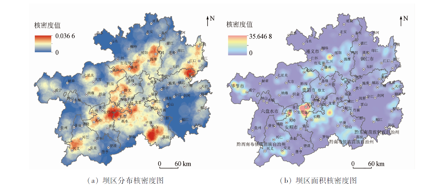
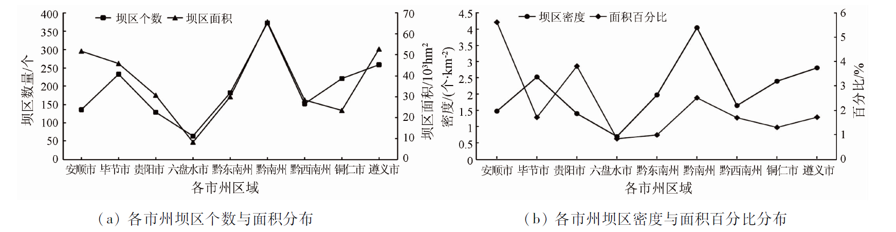
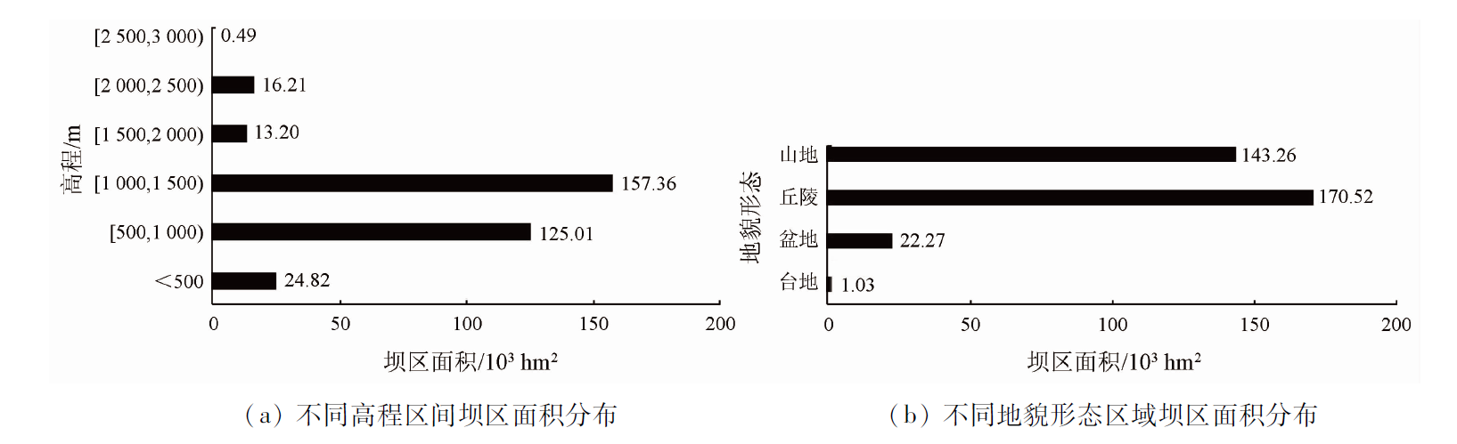
Abstract Featuring many mountains and few flatlands, Guizhou Province has scarce cultivated land resources. Consequently, dam areas become a main carrier for developing high-quality modern agriculture and increasing farmers’ income in Guizhou. The information extraction and characteristic research of dam areas can provide a scientific reference for the adjustment of the agricultural industrial structure and the sustainable utilization of land resources in Guizhou. With the domestic high-resolution satellite images of 2020 with a resolution of 2 m as the main data source, this study extracted, verified, and analyzed the remote sensing images of the dam areas with an area over 500 mu (33.33 hm2) using the global navigation satellite system (GNSS), the geographical information system (GIS), and remote sensing (RS). The remote sensing monitoring results are as follows: ① Guizhou has about 1 749 dam areas with an area of over 33.33 hm2 each, covering a total area of about 337 080.14 hm2, which account for 9.71% of the cultivated land; ② The dam areas with an area of 33.33~66.67 hm2 and 66.67~100 hm2 each account for the highest two proportions and account for 46.65% in total; ③ The dam areas mostly have small areas, with 32.05% on a scale of 10 000 mu (666.67 hm2). Moreover, there is not a proportional relationship between the number of dam areas and their area. The dam areas with an area of over 33.33 hm2 each are mainly distributed in the central region along the northeastern-southwestern area in Guizhou, with Qiannan Buyi and Miao Autonomous Prefecture, Zunyi City, and Anshun City ranking the top three in terms of area. The dam areas are dominated by those at altitudes of 1 000~1 500 m, which account for 46.68%. In addition, the dam areas are largely distributed in hilly and mountainous areas, with a few of them spreading in basins and platforms.
|
| Keywords
dam area over 33.33 hm2
high resolution
information extraction
spatial distribution
Guizhou
|
|
|
|
Issue Date: 07 July 2023
|
|
|
| [1] |
赵宇鸾, 李秀彬, 张颖. 黔桂喀斯特山地与山区类型划分技术与应用[J]. 地球信息科学学报, 2017, 19(7):934-940.
doi: 10.3724/SP.J.1047.2017.00934
|
| [1] |
Zhao Y L, Li X B, Zhang Y. Technology and application of mountainous area divisions in Qian-Gui Karst areas[J]. Journal of Geo-information Science, 2017, 19(7):934-940.
|
| [2] |
韩会庆, 杨广斌, 张凤太. 基于地貌特征的贵州省土地利用时空变化分析[J]. 南京林业大学学报(自然科学版), 2015, 39(5):99-105.
|
| [2] |
Han H Q, Yang G B, Zhang F T. Spatio-temporal analysis of land use changes in Guizhou Province based on landform characteristics[J]. Journal of Nanjing Forestry University (Natural Sciences Edition), 2015, 39(5):99-105.
|
| [3] |
李阳兵, 姚原温, 周志明. 贵州万亩大坝土地利用结构类型研究//刘彦随. 中国农村土地整治与城乡协调发展研究[M]. 贵阳: 贵州科技出版社, 2013.
|
| [3] |
Li Y B, Yao Y W, Zhou Z M. Study on the land use structure of Guizhou Province’s flatlands with≥10 000 mu//Liu Y S. Rural land consolidation and rural-urban harmonies development in China[M]. Guiyang: Guizhou Science Press, 2013.
|
| [4] |
《贵州省农业地貌区划》编写组. 贵州省农业地貌区划[M]. 贵阳: 贵州人民出版社, 1989.
|
| [4] |
The Compile Group of Agricultural Geomorphologic Regionalization in Guizhou Province. Agricultural geomorphologic regionalization in Guizhou Province[M]. Guiyang: Guizhou People Press, 1989.
|
| [5] |
寇建民, 易志. 贵州省万亩耕地大坝调查及成果图集的编制[J]. 测绘通报, 2005, 10:48-53.
|
| [5] |
Kou J M, Yi Z. Survey of 10 000 mu cultivated flatlands of Province Guizhou and atlas compilation[J]. Bulletin of Surveying and Mapping, 2005, 10:48-53.
|
| [6] |
贵州省国土资源厅. 贵州省万亩耕地大坝图集[M]. 长沙: 湖南地图出版社, 2005.
|
| [6] |
Department of Land and Resources of Guizhou Province. Atlas of 10 000 mu cultivated flatland of Guizhou Province[M]. Changsha: Hunan Map Press, 2005.
|
| [7] |
贵州省人民政府办公厅. 贵州省500亩以上坝区种植土地保护办法[J]. 农技服务, 2019, 36(2):7.
|
| [7] |
General Office of Guizhou Provincial People’s Government. Measures for the protection of planting land in dam areas of more than 500 mu in Guizhou Province[J]. Agricultural Technology Service, 2019, 36(2):7.
|
| [8] |
盛佳利, 李阳兵. 贵州省坝子的空间分布及不同地貌区坝子-山地组合类型的探索性划分研究[J]. 贵州师范大学学报(自然科学版), 2018, 36(2):15-21,32.
|
| [8] |
Sheng J L, Li Y B. The basins distribution of space and exploratory divide basin-mountain combination form different landforms in Guizhou Province[J]. Journal of Guizhou Normal University(Natural Sciences), 2018, 36(2):15-21,32.
|
| [9] |
童绍玉, 陈永森, 王学良. 云南坝子的成因与特征研究[J]. 云南地理环境研究, 2007, 19(5):129-133,122.
|
| [9] |
Tong S Y, Chen Y S, Wang X L. A study on thecause of formation for flatland in Yunnan[J]. Yunnan Geo-Graphic Environment Research, 2007, 19(5):129-133,122.
|
| [10] |
张述清, 王爱华, 王宇新, 等. 云贵高原地区坝子划定技术与方法研究——以云南省为例[J]. 地矿测绘, 2012, 28(4):1-4,8.
|
| [10] |
Zhang S Q, Wang A H, Wang Y X, et al. Study on techniques and methods in demarcation of Bazi in Yunnan-Guizhou Plateau:Taking Yunnan Province as an example[J]. Surveying and Mapping of Geology and Mineral Resources, 2012, 28(4):1-4,8.
|
| [11] |
童绍玉. 云南山区与坝区农业利用划分方法探析[J]. 贵州农业科学, 2011, 39(11):89-91.
|
| [11] |
Tong S Y. Analysis on divion methods of mountain area and flatland area in Yunnan[J]. Guizhou Agricultural Sciences, 2011, 39(11):89-91.
|
| [12] |
杨智谋, 赵宇鸾, 薛朝浪. 岩溶区山-坝系统土地利用演化及其空间分异特征[J]. 中国农业资源与区划, 2020, 41(7):153-162.
|
| [12] |
Yang Z M, Zhao Y L, Xue C L. Land use evolution and spatial differentiatio characteristics of mountain-basin system in karst area[J]. Chinese Journal of Agricultural Resources and Regional Planning, 2020, 41(7):153-162.
|
| [13] |
杨子生, 赵乔贵. 基于第二次全国土地调查的云南省坝区县、半山半坝县和山区县的划分[J]. 自然资源学报, 2014, 29(4):564-574.
doi: 10.11849/zrzyxb.2014.04.002
|
| [13] |
Yang Z S, Zhao Q G. Study on dividing flatland county,Semi-mountainous & semiflatland county and mountainous county in Yunnan Province based on the second national land survey[J]. Journal of Natural Resources, 2014, 29(4):564-574.
|
| [14] |
杨广斌, 安裕伦, 张雅梅, 等. 基于3S的贵州省万亩大坝信息提取技术[J]. 贵州师范大学学报(自然科学版), 2003, 21(2):93-110.
|
| [14] |
Yang G B, An Y L, Zhang Y M, et al. Thetechnology of discovering over 10 000 mu basins based on 3S in Guizhou Province[J]. Journal of Guizhou Norrmal University(Natural Sciences), 2003, 21(2):93-110.
|
| [15] |
李军英, 张亚亚, 胡琨菠. 基于航空影像的万亩大坝土地现状调查技术方法探讨[J]. 北京测绘, 2017(6):68-71.
|
| [15] |
Li J Y, Zhang Y Y, Hu K B. Discussion on the technical method of the present situation investigation of ten thousand mu dam land based on aerial images[J]. Beijing Surveying and Mapping, 2017 (6):68-71.
|
| [16] |
叶玮. GIS和DEM技术在贵州万亩耕地大坝调查中的应用探讨[J]. 测绘通报, 2007(1):60-61.
|
| [16] |
Ye W. Application of GIS and DEM technology in dam survey of ten thousand mu cultivated land in Guizhou[J]. Surveying and Mapping Bulletin, 2007 (1):60-61.
|
| [17] |
李倩, 刘毅, 许开鹏, 等. 基于生态空间约束的云贵地区可利用坝区面积与空间分布[J]. 中国环境科学, 2013, 33(12):2215-2219.
|
| [17] |
Li Q, Liu Y, Xu K P, et al. Research of area and distribution of flatland in Yunnan and Guizhou based on ecological spatial constraints[J]. China Environmental Science, 2013, 33(12):2215-2219.
|
| [18] |
姚原温, 李阳兵, 金昭贵, 等. 贵州省大坝土地利用变化及驱动力分析[J]. 长江流域资源与环境, 2014, 23(1):67-74.
|
| [18] |
Yao Y W, Li Y B, Jin Z G, et al. Analysis on land use change and driving forces of dam in Guizhou Province[J]. Resources and environment of Yangtze River Basin, 2014, 23 (1):67-74.
|
| [19] |
杨兴艳, 赵宇鸾, 李秀彬. 黔桂岩溶山区土地利用变化的社会经济因素分析[J]. 中国岩溶, 2019, 38(1):88-99.
|
| [19] |
Yang X Y, Zhao Y L, Li X B. Analysis of land-use changes and Socio-economic factors in Karst mountainous areas of Guizhou and Guangxi[J]. Carsologica Sinica, 2019, 38(1):88-99.
|
| [20] |
陈文华, 甘淑. 云南山地坝区土地利用变化及其驱动分析——以保山坝子为例[J]. 云南地理环境研究, 2009, 21(6):34-39.
|
| [20] |
Chen W H, Gan S. Lucc and its driving forces in mountain basins of Yunnan Province:A case study in Baoshan basin[J]. Yunnan Geographic Environment Research, 2009, 21(6):34-39.
|
| [21] |
刘亚香, 李阳兵. 乡村转型背景下贵州坝子土地利用生产功能的空间演变[J]. 地理研究, 2020, 39(2):430-446.
doi: 10.11821/dlyj020180650
|
| [21] |
Liu Y X, Li Y B. Spatial evolution of land use and production function in Bazi,Guizhou Province under the background of rural transformation[J]. Geographic Research, 2020, 39 (2):430-446.
|
| [22] |
陈会, 李阳兵, 唐家发. 贵州坝子现代农业功能分布特征研究[J]. 地球科学进展, 2019, 34(9):962-973.
doi: 10.11867/j.issn.1001-8166.2019.09.0962
|
| [22] |
Chen H, Li Y B, Tang J F. Distribution characteristics of modern agricultural functions in Bazi,Guizhou[J]. Progress in Earth Sciences, 2019, 34 (9):962-973.
|
| [23] |
李阳兵, 姚原温, 谢静, 等. 贵州省山地—坝地系统土地利用与景观格局时空演变[J]. 生态学报, 2014, 34(12):3257-3265.
|
| [23] |
Li Y B, Yao Y W, Xie J, et al. Spatial-temporalevolution of land use and landscape pattern of the mountain-basin system in Guizhou Province[J]. Acta Ecologica Sinica, 2014, 34(12):3257-3265.
|
| [24] |
刘亚香, 李阳兵, 易兴松, 等. 贵州典型坝子土地利用强度空间演变及景观格局响应[J]. 应用生态学报, 2017, 28(11):3691-3702.
doi: 10.13287/j.1001-9332.201711.019
|
| [24] |
Liu Y X, Li Y B, Yi X S, et al. Spatial evolution of land use intensity and landscape pattern response of the typical basins in Guizhou Province,China[J]. Chinese Journal of Applied Ecology, 2017, 28(11):3691-3702.
|
| [25] |
姚原温, 李阳兵, 龙东妹. 贵州省黄家坝万亩大坝土地覆被及景观格局变化[J]. 贵州农业科学, 2015, 43(1):179-184.
|
| [25] |
Yao Y W, Li Y B, Long D M. Land cover change and landscape pattern of Guizhou Huangjia 10 000-Mu basins[J]. Guizhou Agricultural Sciences, 2015, 43(1):179-184.
|
| [26] |
李阳兵, 陈会, 罗光杰. 贵州不同规模等级坝子空间分布特征研究[J]. 地理科学, 2019, 39(11):1830-1840.
doi: 10.13249/j.cnki.sgs.2019.11.018
|
| [26] |
Li Y B, Chen H, Luo G J. Spatial distribution of different scale flatland in Guizhou Province,China[J]. Scientia Geographica Sinica, 2019, 39(11):1830-1840.
|
| [27] |
韩德军, 朱道林. 贵州省土地利用与区域经济耦合关系分析[J]. 农业工程学报, 2012, 28(15):1-8.
|
| [27] |
Han D J, Zhu D L. Coupling relationship analysis of land use and regional economy in Guizhou Province[J]. Transactions of the Chinese Society of Agricultural Engineering, 2012, 28(15):1-8.
|
| [28] |
张满姣. 贵州500亩以上坝区产业发展现状分析[J]. 安顺学院学报, 2021, 23(4):38-41.
|
| [28] |
Zhang M J. Analysis on the present situation of industrial development in dam area of more than 500 mu in Guizhou[J]. Journal of Anshun University, 2021, 23(4):38-41.
|
| [29] |
王永明, 王美霞, 吴殿廷, 等. 贵州省乡村贫困空间格局与形成机制分析[J]. 地理科学, 2017, 37(2):217-227.
doi: 10.13249/j.cnki.sgs.2017.02.007
|
| [29] |
Wang Y M, Wang M X, Wu D T, et al. Spatial patterns and determinants of rural poverty:A Case of Guizhou Province,China[J]. Scientia Geographica Sinica, 2017, 37(2):217-227.
|
| [30] |
杨明德. 论贵州岩溶水赋存的地貌规律性[J]. 中国岩溶, 1982,(2):85-91.
|
| [30] |
Yang M D. The geomorphological of Karst water occurences in Guizhou plateau[J]. Carsologica Sinica, 1982,(2):81-91.
|
| [31] |
李宗发. 贵州喀斯特地貌分区[J]. 贵州地质, 2011, 28(3):177-181.
|
| [31] |
Li Z F. Division of Karst landform in Guizhou[J]. Guizhou Geology, 2011, 28(3):177-181,234.
|
|
Viewed |
|
|
|
Full text
|
|
|
|
|
Abstract
|
|
|
|
|
Cited |
|
|
|
|
| |
Shared |
|
|
|
|
| |
Discussed |
|
|
|
|
 2023,
Vol. 35
2023,
Vol. 35