|
|
|
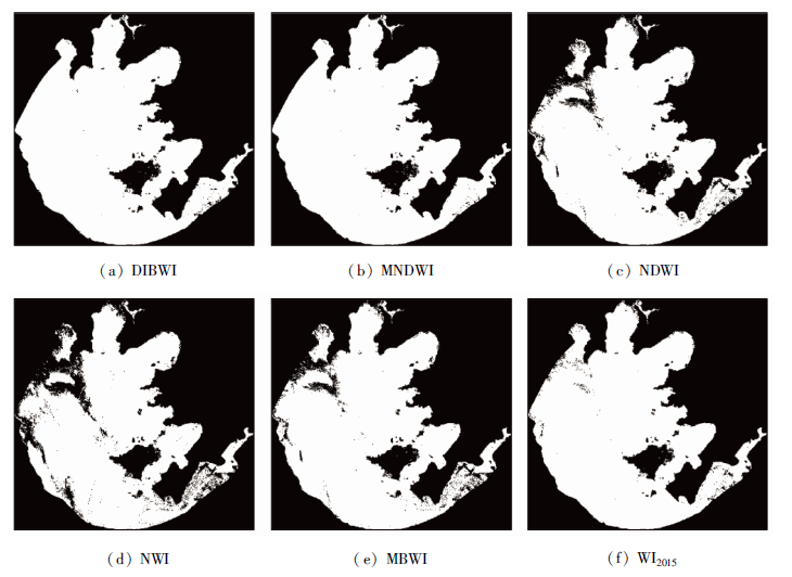
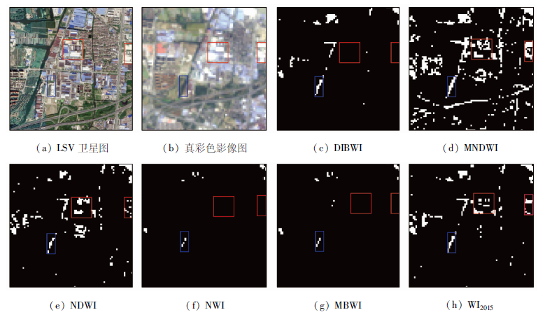
Abstract Since the 21st century, the outbreak of cyanobacteria in the Taihu Lake has seriously affected the development and utilization of local water resources. Based on Landsat8 imagery, this paper analyzes the spectral reflection characteristics of non-cyanobacteria water and cyanobacteria water. Cyanobacteria water shows strong reflectance characteristics in the near-infrared band, but the reflectance characteristics in the blue, green, red and shortwave-infrared bands are the same as those in non-cyanobacteria water. On such a basis, a method for extracting cyanobacteria water information, i.e., double infrared band water index (DIBWI), is proposed. On the basis of the Landsat8 imageries of 2014 and 2017 in Taihu Lake area, the comparison and analysis were made with the results of normalized difference water index (NDWI), modified normalized difference water index (MNDWI), new water index (NWI), multi-band water index (MBWI) and water index 2015 (WI2015), and the data of 2013, 2016 and 2018 were used for verification. The results show that DIBWI can extract the cyanobacteria water information, effectively eliminate the influence of cyanobacteria and better inhibit the background features. The overall accuracy is above 98%, and the Kappa coefficient is more than 0.95, which can provide technical support for the protection and reasonable development and utilization of water resources in Taihu Lake area.
|
| Keywords
Landsat8
cyanobacteria
water information extraction
DIBWI
|
|
|
|
Corresponding Authors:
WEN Guangchao
E-mail: 136794517@qq.com;149248664@qq.com
|
|
Issue Date: 23 December 2020
|
|
|
| [1] |
李世杰. 关于湖泊(水库)环境演变与地球化学研究的几点建议[J]. 矿物岩石地球化学通报, 2016,35(4):2.
url: http://www.bmpg.ac.cn/CN/abstract/abstract11504.shtml
|
| [1] |
Li S J. Suggestions on the environmental evolution and geochemical research of lakes (reservoirs)[J]. Bulletin of Mineralogy,Petrology and Geochemistry, 2016,35(4):2.
url: http://www.bmpg.ac.cn/CN/abstract/abstract11504.shtml
|
| [2] |
Liu J, Yang W. Water sustainability for China and beyond[J]. Science, 2012,337(6095):649-650.
doi: 10.1126/science.1219471
url: https://www.sciencemag.org/lookup/doi/10.1126/science.1219471
|
| [3] |
Feng M, Sexton J O, Channan S, et al. A global,high-resolution (30-m) inland water body dataset for 2000:First results of a topo-graphic-spectral classification algorithm[J]. International Journal of Digital Earth, 2015:1-21.
|
| [4] |
封红娥, 李家国, 朱云芳, 等. GF-1与Landsat8水体叶绿素a浓度协同反演——以太湖为例[J]. 国土资源遥感, 2019,31(4):182-189.doi: 10.6046/gtzyyg.2019.04.24.
|
| [4] |
Feng H E, Li J G, Zhu Y F, et al. Synergistic inversion method of chlorophyll a concentration in GF-1 and Landsat8 imagery:A case study of the Taihu Lake[J]. Remote Sensing for Land and Resoures, 2019,31(4):182-189.doi: 10.6046/gtzyyg.2019.04.24.
|
| [5] |
朱喜. 太湖蓝藻大爆发的警示和启发[J]. 上海企业, 2007(7):7-9,13.
|
| [5] |
Zhu X. Warning and inspiration of cyanobacteria bloom in Taihu Lake[J]. Shanghai Enterprise, 2007(7):7-9,13.
|
| [6] |
朱喜, 朱云. 太湖蓝藻暴发治理存在的问题与治理思路[J]. 环境工程技术学报, 2019,9(6):714-719.
|
| [6] |
Zhu X, Zhu Y. Problems and countermeasures of controlling cyanobacteria bloom in Taihu Lake[J]. Journal of Environmental Engineering Technology, 2019,9(6):714-719.
|
| [7] |
张毅, 陈成忠, 吴桂平, 等. 遥感影像空间分辨率变化对湖泊水体提取精度的影响[J]. 湖泊科学, 2015,27(2):335-342.
|
| [7] |
Zhang Y, Chen C Z, Wu G P, et al. Effects of spatial scale on water surface delineation with satellite images[J]. Journal of Lake Sciences, 2015,27(2):335-342.
|
| [8] |
孙佩, 汪权方, 张梦茹, 等. 基于NDVI-MNDWI特征空间的水体信息增强方法研究[J]. 湖北大学学报(自然科学版), 2018,40(6):574-579.
|
| [8] |
Sun P, Wang Q F, Zhang M R, et al. A method to enhance information of water cover based on feature space of NDVI and MNDWI[J]. Journal of Hubei University(Natural Science), 2018,40(6):574-579.
|
| [9] |
Ashraf M, Nawaz R. A comparison of change detection analyses using different band algebras for baraila wetland with NASA’s multi-temporal Landsat dataset[J]. Journal of Geographic InformationSystem, 2015,7(1):1-19.
|
| [10] |
McFeeters S K. The use of the normalized difference water index(NDWI) in the delineation of open water feature[J]. International Journal of Remote Sensing, 1996,17(7):1425-1432.
|
| [11] |
徐涵秋. 利用改进的归一化差异水体指数(MNDWI)提取水体信息的研究[J]. 遥感学报, 2005,9(5):589-595.
|
| [11] |
Xu H Q. A study on information extraction of water body with the modified normalized difference water index(MNDWI)[J]. Journal of Remote Sensing, 2005,9(5):589-595.
|
| [12] |
丁凤. 基于新型水体指数(NWI)进行水体信息提取的实验研究[J]. 测绘科学, 2009,34(4):155-157.
|
| [12] |
Ding F. Study on information extraction of water body with a new water index(NWI)[J]. Science of Surveying and Mapping, 2009,34(4):155-157.
|
| [13] |
Fisher A, Flood N, Danaher T. Comparing Landsat water index methods for automated water classification in eastern Australia[J]. Remote Sensing of Environment, 2016,175:167-182.
|
| [14] |
Wang X B, Xie S P, Zhang X L, et al. A robust multi-band water index (MBWI) for automated extraction of surface water from Landsat8 OLI imagery[J]. International Journal of Applied Earth Observation and Geoinformation, 2018,68:73-91.
|
| [15] |
水利部太湖流域管理局. 2017年太湖健康状况报告[R]. 上海:水利部太湖流域管理局, 2017.
|
| [15] |
Water Resources Department of the Taihu Basin. Health report of Taihu Lake in 2017[R]. Shanghai:Water Resources Department of the Taihu Basin, 2017.
|
| [16] |
赵英时. 遥感应用分析原理与方法[M]. 北京: 科学出版社, 2003.
|
| [16] |
Zhao Y S. Principles and methods of remote sensing application analysis[M]. Beijing: Science Press, 2003.
|
| [17] |
陈瑞弘. 太湖流域水质污染与水质变化的空间分析[J]. 环境与发展, 2018,30(5):54,56.
|
| [17] |
Chen R H. Taihu Lake basin water quality contamination water quality electromyographic space analysis[J]. Environment and Development, 2018,30(5):54,56.
|
| [18] |
周冠华, 柳钦火, 马荣华, 等. 基于半分析模型的波段最优化组合反演混浊太湖水体叶绿素a[J]. 湖泊科学, 2008(2):17-23.
|
| [18] |
Zhou G H, Liu Q H, Ma R H, et al, Inversion of chlorophyll-a concentration in turbid water of lake Taihu based on optimized multi-spectral combination[J]. Journal of Lake Sciences, 2008(2):17-23.
|
| [19] |
Li W B, Du Z Q, Ling F, et al. A comparison of land surface water mapping using the normalized difference water index from TM,ETM+ and ALI[J]. Remote Sensing, 2013,5(11):5530-5549.
|
|
Viewed |
|
|
|
Full text
|
|
|
|
|
Abstract
|
|
|
|
|
Cited |
|
|
|
|
| |
Shared |
|
|
|
|
| |
Discussed |
|
|
|
|
 2020,
Vol. 32
2020,
Vol. 32
 ), XIE Hongbo, WEN Guangchao(