|
|
 |
|

|
|
|
Satellite remote sensing-assisted comparative monitoring of dynamic characteristics of macroalgae aquaculture in Weihai City, Shandong Province, China |
HOU Yingzhuo1,2,3( ), JI Ling4, XING Qianguo1,2,3(), SHENG Dezhi1,2,3 ), JI Ling4, XING Qianguo1,2,3(), SHENG Dezhi1,2,3 |
1. CAS Key Laboratory of Coastal Environmental Processes and Ecological Remediation, Yantai Institute of Coastal Zone Research, Chinese Academy of Sciences, Yantai 264003, China
2. Shandong Key Laboratory of Coastal Environmental Processes, Yantai 264003, China
3. University of Chinese Academy of Sciences, Beijing 100049, China
4. Yantai Marine Environment Monitoring Center, Yantai 264006, China |
|
|
|
|
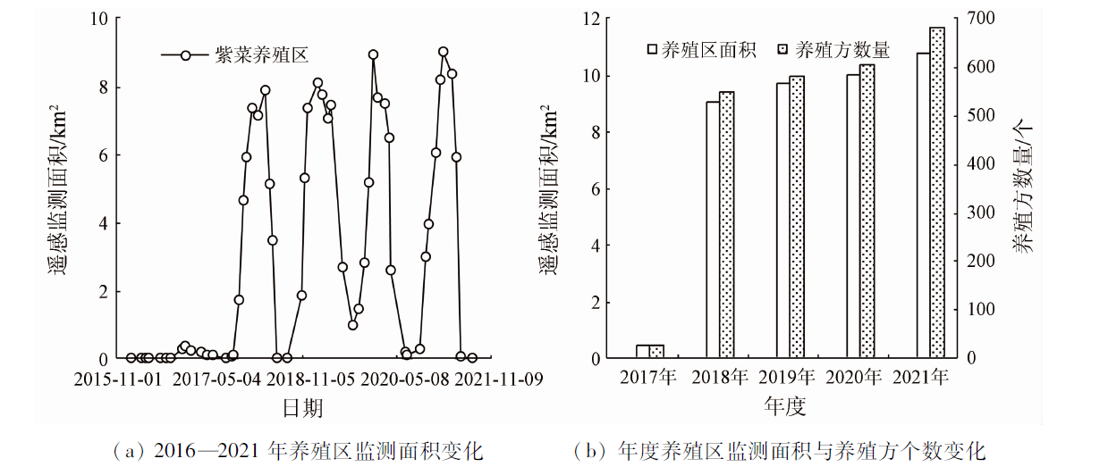
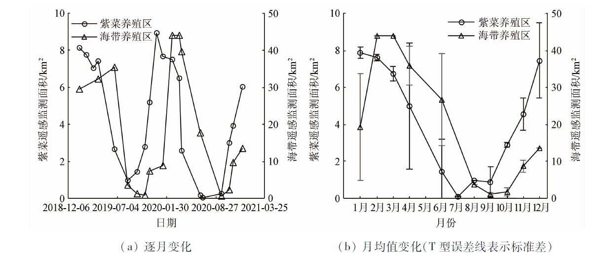
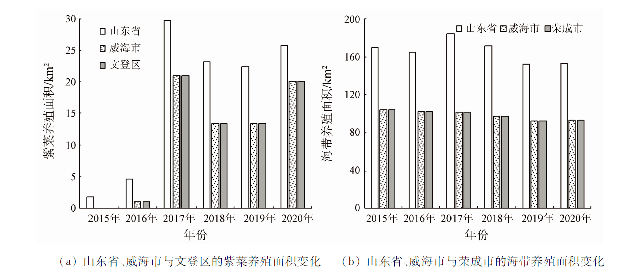
Abstract Monitoring the spatio-temporal dynamic changes in macroalgae aquaculture is crucial to its environmental management. However, few studies have been reported on the comparative monitoring of different macroalgae species. Based on images of the Sentinel-2 satellite and using the normalized difference vegetation index (NDVI) and the support vector machine (SVM), this study monitored the dynamic characteristics of both the Porphyra aquaculture area in the sea area of southern Wendeng District, Weihai City, Shandong Province and the kelp aquaculture area in the sea area of southern Rongcheng City, Weihai City. The results show that: ① The Porphyra aquaculture in Wendeng District was first captured in the satellite images of 2016, which is the same as the first year of Porphyra aquaculture in this city; the extraction method used in this study performed well in extracting the information about both the Porphyra and the kelp aquaculture areas overall, with the overall accuracy of 84% and above; ② During 2017—2021, the Porphyra aquaculture area monitored through remote sensing increased year by year and showed a trend far away from the shore; ③ The Porphyra and kelp aquaculture areas monitored both showed seasonal variations (high in winter and low in summer) of cold-water macroalgae aquaculture, but the minimum and maximum values of the Porphyra aquaculture area appeared 1~2 months earlier than those of the kelp aquaculture area. Compared with statistical yearbooks, satellite remote sensing can provide more accurate spatio-temporal information on macroalgae aquaculture. This study can be used as a reference in terms of monitoring technology and data for the management of macroalgae aquaculture in coastal areas of northern China.
|
| Keywords
Sentinel-2
macroalgae
Porphyra
kelp
Shandong Peninsula
Yellow Sea
|
|
|
|
Issue Date: 07 July 2023
|
|
|
| [1] |
刘福利, 牛建峰, 隋正红, 等. 中国经济海藻养殖技术概况与展望[J]. 中国农业科技导报, 2020, 22(12):1-9.
doi: 10.13304/j.nykjdb.2019.0795
|
| [1] |
Liu F L, Niu J F, Sui Z H, et al. Overview and prospects of China economic seaweed cultivation technology[J]. Journal of Agricultural Science and Technology, 2020, 22(12):1-9.
doi: 10.13304/j.nykjdb.2019.0795
|
| [2] |
卢霞, 顾杨, 王晓静, 等. 连云港近海紫菜养殖区遥感识别、空间变异和驱动分析[J]. 海洋科学, 2018, 42(7):87-96.
|
| [2] |
Lu X, Gu Y, Wang X J, et al. The identification of Porphyra culture area by remote sensing and spatial distribution change and driving factors analysis[J] Marine Sciences, 2018, 42(7):87-96.
|
| [3] |
李涵, 青平, 张晓恒, 等. 我国藻类产业发展现状、问题及对策建议[J]. 中国农业科技导报, 2021, 23(1):12-20.
doi: 10.13304/j.nykjdb.2019.0896
|
| [3] |
Li H, Qing P, Zhang X H, et al. Current status,problems and countermeasures of algae industry development in China[J]. Journal of Agricultural Science and Technology, 2021, 23(1):12-20.
|
| [4] |
岳冬冬, 王鲁民, 耿瑞, 等. 中国近海藻类养殖生态价值评估初探[J]. 中国农业科技导报, 2014, 16(3):126-133.
|
| [4] |
Yue D D, Wang L M, Geng R, et al. Initial assessment of seaweed farming ecological value in coastal waters of China[J]. Journal of Agricultural Science and Technology, 2014, 16(3):126-133.
|
| [5] |
魏振宁, 邢前国, 郭瑞宏, 等. 基于遥感的2000—2015年南黄海紫菜养殖空间分布变化研究[J]. 海洋技术学报, 2018, 37(4):17-22.
|
| [5] |
Wei Z N, Xing Q G, Guo R H, et al. Study on the spatial distribution variation of Porphyra aquaculture in the southern Yellow Sea during the period 2000—2015 retrieved by satellite remote sensing[J]. Journal of Ocean Technology, 2018, 37(4):17-22.
|
| [6] |
Xing Q, An D, Zheng X, et al. Monitoring seaweed aquaculture in the Yellow Sea with multiple sensors for managing the disaster of macroalgal blooms[J]. Remote Sensing of Environment, 2019, 231:111279.
doi: 10.1016/j.rse.2019.111279
url: https://linkinghub.elsevier.com/retrieve/pii/S0034425719302986
|
| [7] |
刘材材, 徐韧, 何培民, 等. 南黄海绿潮暴发与紫菜养殖的关系[J]. 海洋科学, 2017, 41(2):35-43.
|
| [7] |
Liu C C, Xu R, He P M, et al. Research on the relations between green tide and Porphyra cultivation in the south Yellow Sea[J]. Marine Sciences, 2017, 41(2):35-43.
|
| [8] |
许海蓬, 张彦彦, 郑剑. 基于SR-NDVI和中值滤波的连云港海域紫菜筏架自动提取研究[J]. 海洋技术学报, 2021, 40(2):1-8.
|
| [8] |
Xu H P, Zhang Y Y, Zheng J. Research on the automatic extraction of floating raft aquaculture based on SR-NDVI and median filtering in Lianyungang[J]. Journal of Ocean Technology, 2021, 40(2):1-8.
|
| [9] |
郭瑞宏. 江苏沿海紫菜养殖时空动态遥感(2000—2015)[D]. 北京: 中国科学院大学, 2017.
|
| [9] |
Guo R H. Evaluation on the changes in the seaweed (Porphyra yezoensis) aquaculture in Jiangsu coastal waters using remote sensing[D]. Beijing: University of Chinese Academy of Sciences, 2017.
|
| [10] |
初佳兰, 邵光辉, 赵建华, 等. 高分一号的浮筏养殖信息提取方法[J]. 测绘科学, 2020, 45(1):92-98.
|
| [10] |
Chu J L, Shao G H, Zhao J H, et al. Information extraction of floating raft aquaculture based on GF-1[J]. Science of Surveying and Mapping, 2020, 45(1):92-98.
|
| [11] |
武易天, 陈甫, 马勇, 等. 基于Landsat8数据的近海养殖区自动提取方法研究[J]. 国土资源遥感, 2018, 30(3):96-105.doi:10.6046/gtzyyg.2018.03.14.
doi: 10.6046/gtzyyg.2018.03.14
|
| [11] |
Wu Y T, Chen F, Ma Y, et al. Research on automatic extraction method for coastal aquaculture area using Landsat8 data[J]. Remote Sensing for Land and Resources, 2018, 30(3):96-105.doi:10.6046/gtzyyg.2018.03.14.
doi: 10.6046/gtzyyg.2018.03.14
|
| [12] |
Won E S, Ouchi K, Yang C S. Extraction of underwater laver cultivation nets by SAR polarimetric entropy[J]. IEEE Geoscience and Remote Sensing Letters, 2013, 10(2):231-235.
doi: 10.1109/LGRS.2012.2199077
url: http://ieeexplore.ieee.org/document/6221949/
|
| [13] |
胡姣婵, 黄梦迪, 于浩洋, 等. 基于哨兵二号遥感影像的近海养殖区提取方法研究[J]. 海洋环境科学, 2022, 41(4):619-627.
|
| [13] |
Hu J C, Huang M D, Yu H Y, et al. Research on extraction method of offshore aquaculture area based on Sentinel-2 remote sensing imagery[J]. Marine Environmental Science, 2022, 41(4):619-627.
|
| [14] |
Lu X, Zhang Y Z, Zhang S, et al. Spatial change analysis of Porphyra yezoensis aquaculture in the Lianyungang coastal area by the use of remote sensing and geographic information system technology[J]. Journal of the Indian Society of Remote Sensing, 2019, 47(9):1609-1622.
doi: 10.1007/s12524-019-00987-7
|
| [15] |
曹万云. 荣成海带养殖时空变化与适宜性评价研究[D]. 烟台: 鲁东大学, 2016.
|
| [15] |
Cao W Y. Spatial-temporal variation and suitability evaluation of kelp culture in Rongcheng[D]. Yantai: Ludong University, 2016.
|
| [16] |
海洋网. 威海海洋食品又添新品文登千亩紫菜收割上市[EB/OL].(2017-01-10)[2022-02-24]. http://www.hellosea.net/Product/7/2017-01-10/35877.html?cktove=ayvg03.
url: http://www.hellosea.net/Product/7/2017-01-10/35877.html?cktove=ayvg03
|
| [16] |
Ocean Net. Weihai seafood has added new products Wendeng thousand Mu seaweed harvested and listed[EB/OL].(2017-01-10)[2022-02-24]. http://www.hellosea.net/Product/7/2017-01-10/35877.html?cktove=ayvg03.
url: http://www.hellosea.net/Product/7/2017-01-10/35877.html?cktove=ayvg03
|
| [17] |
有贺祐胜, 于廷林. 条斑紫菜(Porphyra yezoensis)的颜色和色素[J]. 国外水产, 1982(4):8-13.
|
| [17] |
Aruga Y, Yu T L. Color and pigment of Porphyra yezoensis[J]. Foreign Aquatic Products, 1982(4):8-13.
|
| [18] |
吴健生, 潘况一, 彭建, 等. 基于QUEST决策树的遥感影像土地利用分类——以云南省丽江市为例[J]. 地理研究, 2012, 31(11):1973-1980.
|
| [18] |
Wu J S, Pan K Y, Peng J, et al. Research on the accuracy of TM images land-use classification based on QUEST decision tree: A case study of Lijiang in Yunnan[J]. Geographical Research, 2012, 31(11):1973-1980.
doi: 10.11821/yj2012110005
|
|
Viewed |
|
|
|
Full text
|
|
|
|
|
Abstract
|
|
|
|
|
Cited |
|
|
|
|
| |
Shared |
|
|
|
|
| |
Discussed |
|
|
|
|
 2023,
Vol. 35
2023,
Vol. 35