|
|
 |
|

|
|
|
Classification of tea garden based on multi-source high-resolution satellite images using multi-dimensional convolutional neural network |
LIAO Kuo1,2( ), NIE Lei3, YANG Zeyu4(), ZHANG Hongyan3, WANG Yanjie3, PENG Jida1,2, DANG Haofei1,2, LENG Wei3 ), NIE Lei3, YANG Zeyu4(), ZHANG Hongyan3, WANG Yanjie3, PENG Jida1,2, DANG Haofei1,2, LENG Wei3 |
1. Fujian Institute of Meteorological Sciences, Fuzhou 350008, China
2. Wuyi Mountain National Climate Observatory, Wuyishan 354300, China
3. Wuhan Jiahe Technology Co., Ltd., Wuhan 430200, China
4. Zhejiang Wanwei Spatial Information Technology Co., Ltd., Nanjing 210012, China |
|
|
|
|
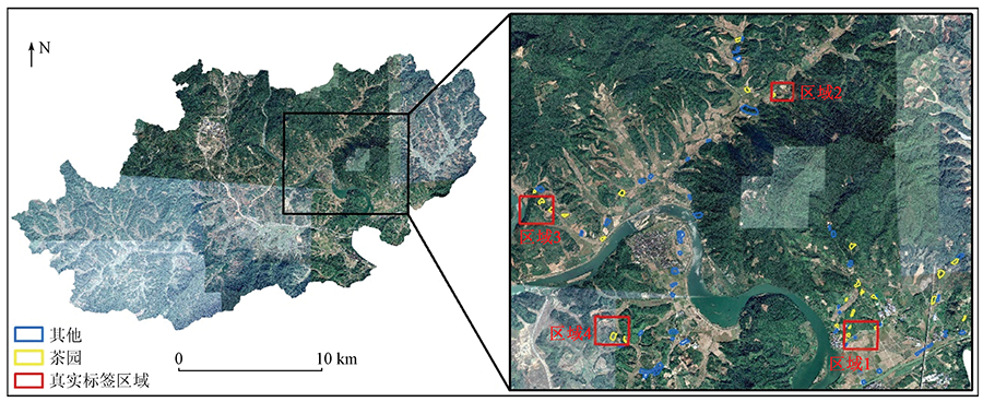
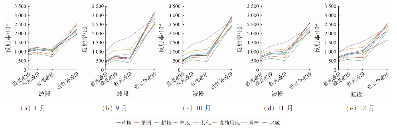
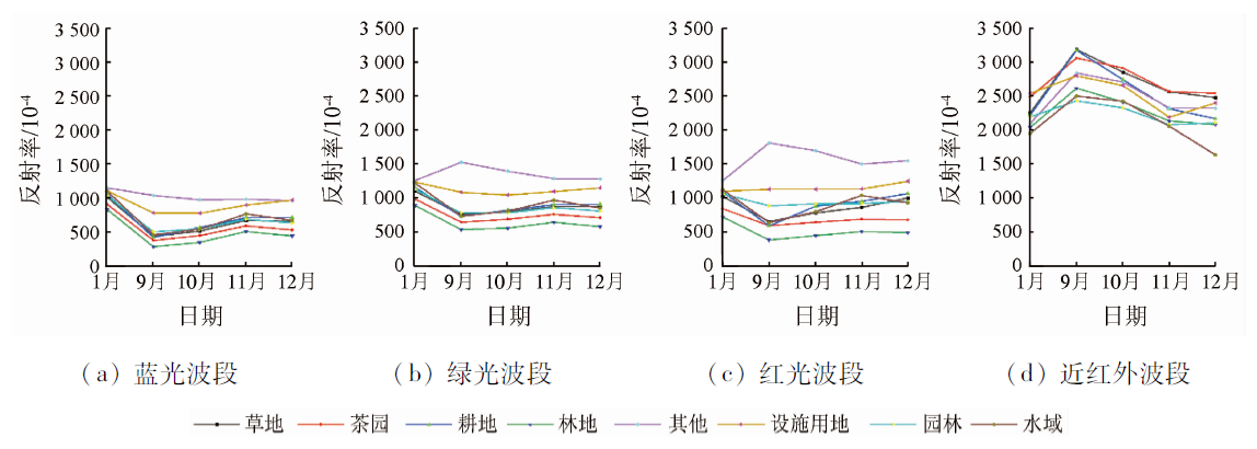
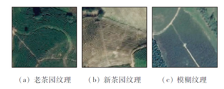
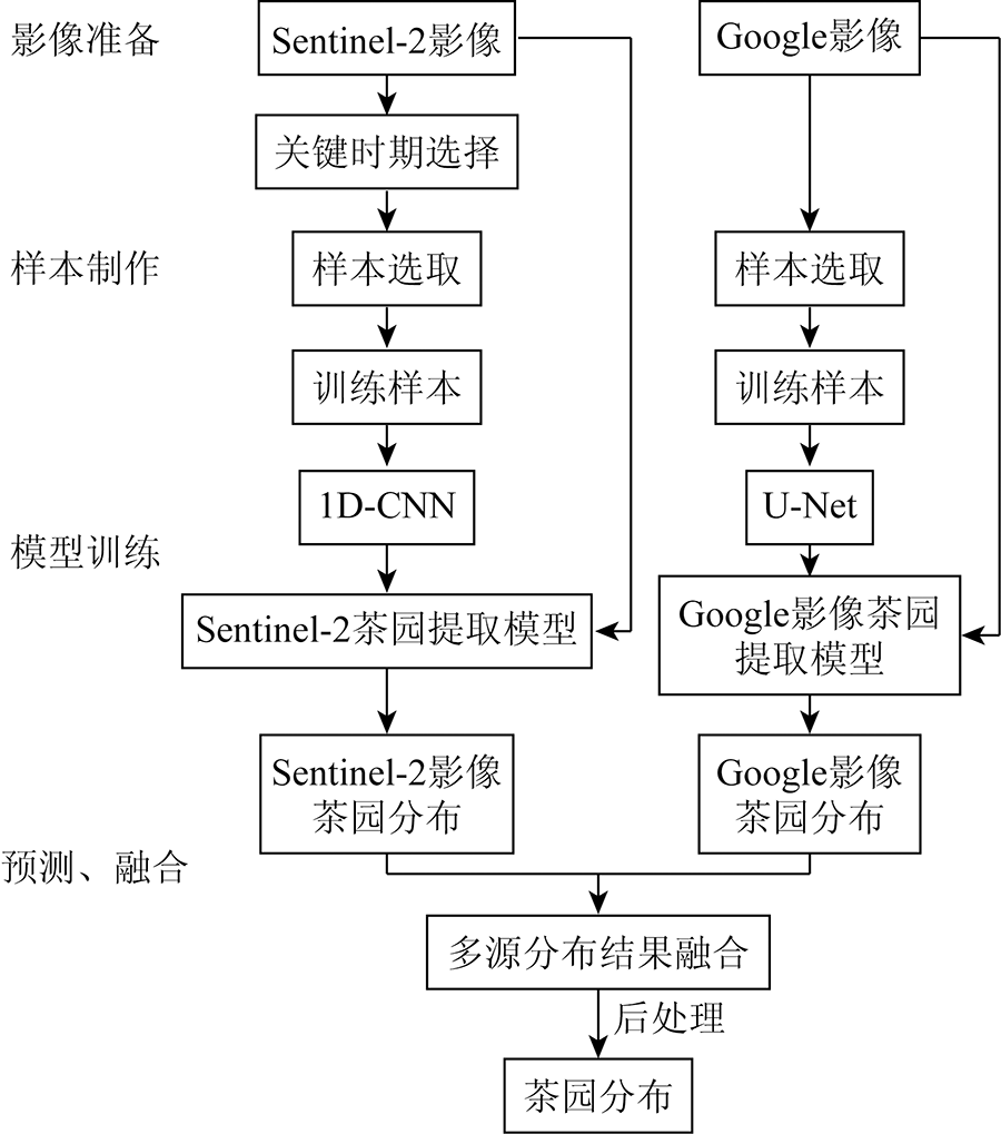
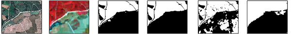
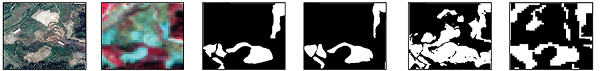
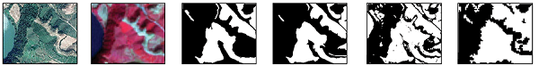
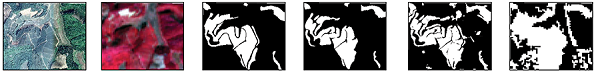
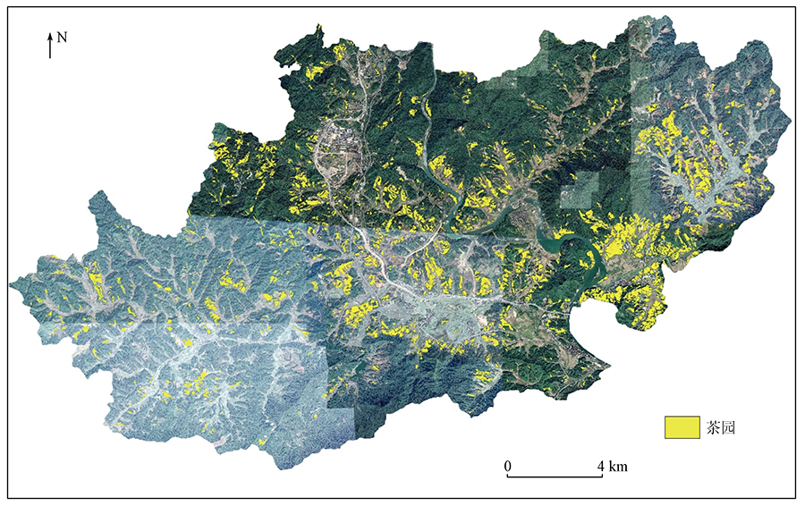
Abstract The terrain conditions and tea plantation structure of Wuyishan City are complex, with cloudy and rainy weather, so it is difficult to obtain satellite images here. To address the problem of difficult extraction of tea gardens from a single image source, we investigated the spectral information of Sentinel-2 images and the texture features of Google images in Xintian Town, Wuyishan City, coupled with which a tea garden classification method based on multi-source high-resolution satellite images and multidimensional convolutional neural networks (MM-CNN) was established. In this method, tea gardens and suspected tea gardens were extracted, respectively, with two models developed with images with different spatial resolutions, based on one- and two-dimensional CNN. Results obtained with the two CNN models were combined, and the high-accuracy distribution of tea gardens in the study area was generated in a relatively economical and efficient way. The results showed that the spatial distribution accuracy of the tea gardens identified by MM-CNN is better than that of the single image source method. The MM-CNN method is highly universal and robust and provides a reference method for efficiently monitoring the distribution of tea gardens in large-scale hilly areas of South China.
|
| Keywords
Wuyishan City
tea garden
convolutional neural network
semantic segmentation
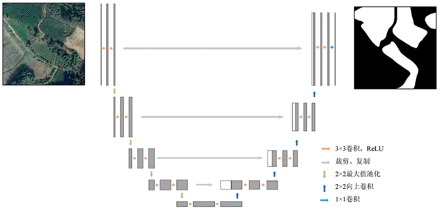
U-Net
1D-CNN
Sentinel-2
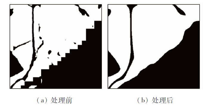
Google image
|
|
|
|
Corresponding Authors:
YANG Zeyu
E-mail: 85832679@qq.com;yangzywhu@sina.cn
|
|
Issue Date: 20 June 2022
|
|
|
| [1] |
李龙伟, 李楠, 陆灯盛. 多时相Sentinel-2影像在浙西北茶园信息提取中的应用[J]. 浙江农林大学学报, 2019, 36(5):841-848.
|
| [1] |
Li L W, Li N, Lu D S. Mapping tea gardens spatial distribution in northwestern Zhejiang Province using multi-temporal Sentinel-2 imagery[J]. Journal of Zhejiang A & F University, 2019, 36(5):841-848.
|
| [2] |
Phan P, Chen N, Xu L, et al. Using multi-temporal MODIS NDVI data to monitor tea status and forecast yield:A case study at Tanuyen,Laichau,Vietnam[J]. Remote Sensing, 2020, 12(11):1814.
doi: 10.3390/rs12111814
url: https://www.mdpi.com/2072-4292/12/11/1814
|
| [3] |
Das A C. Integrating an expert system,GIS,and satellite remote sensing to evaluate land suitability for sustainable tea production in Bangladesh[J]. Remote Sensing, 2020, 12(24):25.
doi: 10.3390/rs12010025
url: https://www.mdpi.com/2072-4292/12/1/25
|
| [4] |
何小娟. 名山县茶园生态系统碳汇能力分析[D]. 成都: 四川农业大学, 2013.
|
| [4] |
He X J. Analysis the carbon sequestration capacity of the tea plantation of Mingshan County[D]. Chengdu: Sichuan Agricultural University, 2013.
|
| [5] |
赵晓晴, 王萍, 荆林海, 等. 时序Sentinel-2A影像光谱特征的茶园提取应用[J]. 测绘科学, 2020, 264(6):84-92.
|
| [5] |
Zhao X Q, Wang P, Jing L H, et al. The application of spectral characteristics of time series Sentinel-2A images in tea land extraction[J]. Science of Surveying and Mapping, 2020, 264(6):84-92.
|
| [6] |
Zhu J, Pan Z, Wang H, et al. An improved multi-temporal and multi-feature tea plantation identification method using Sentinel-2 imagery[J]. Sensors, 2019, 19(9):2087.
doi: 10.3390/s19092087
url: https://www.mdpi.com/1424-8220/19/9/2087
|
| [7] |
Huang Y, Li S, Yuang L, et al. Estimating tea plantation area based on multi-source satellite data[C]// 2019 8th International Conference on Agro-Geoinformatics (Agro-Geoinformatics), 2019.
|
| [8] |
杨艳魁, 陈芸芝, 吴波, 等. 基于高分二号影像结合纹理信息的茶园提取[J]. 江苏农业科学, 2019, 47(2):210-214.
|
| [8] |
Yang Y K, Chen Y Z, Wu B, et al. Extraction of tea plantation image based on GF-2 image and texture information[J]. Jiangsu Agricultural Sciences, 2019, 47(2):210-214.
|
| [9] |
徐伟燕, 孙睿, 金志凤. 基于资源三号卫星影像的茶树种植区提取[J]. 农业工程学报, 2016(s1):161-168.
|
| [9] |
Xu W Y, Sun R, Jin Z F. Extracting tea plantations based on ZY-3 satellite data[J]. Transactions of the Chinese Society of Agricultural Engineering, 2016(s1):161-168.
|
| [10] |
Blaschke T, Hay G J, Kelly M, et al. Geographic object-based image analysis-Towards a new paradigm-sciencedirect[J]. ISPRS Journal of Photogrammetry and Remote Sensing, 2014, 87:180-191.
doi: 10.1016/j.isprsjprs.2013.09.014
url: https://linkinghub.elsevier.com/retrieve/pii/S0924271613002220
|
| [11] |
陈慧, 江洪, 蒋世豪. 面向对象最优分割尺度下的茶园提取[J]. 测绘与空间地理信息, 2020, 43(12):17-20.
|
| [11] |
Chen H, Jiang H, Jiang S H. Tea plantation extraction under object-oriented optimal segmentaton scale[J]. Geomatics & Spatial Information Technology, 2020, 43(12):17-20.
|
| [12] |
吴锦玉. 基于高分遥感影像纹理空间模式增强的非参数化茶园识别方法研究[D]. 昆明: 云南师范大学, 2020.
|
| [12] |
Wu J Y. Research on non-parametric tea garden recognition method based on texture spatial model enhancement of high-resolution remote sensing image[D]. Kunming: Yunnan Noraml Univerity, 2020.
|
| [13] |
Jamil A, Bayram B. The delineation of tea gardens from high resolution digital orthoimages using mean-shift and supervised machine learning methods[J]. Geocarto International, 2021, 36(7):758-772.
doi: 10.1080/10106049.2019.1622597
url: https://www.tandfonline.com/doi/full/10.1080/10106049.2019.1622597
|
| [14] |
许光明. 基于面向对象和多源数据融合的茶园遥感提取研究[D]. 西安: 陕西师范大学, 2016.
|
| [14] |
Xu G M. Research on tea garden remote sensing extraction based on object-oriented and multi-Metadata[D]. Xi’an: Shaanxi Normal University, 2016.
|
| [15] |
马超, 杨飞, 王学成. 基于中尺度光谱和时序物候特征提取南方丘陵山区茶园[J]. 国土资源遥感, 2019, 31(1):141-148.doi: 10.6046/gtzyyg.2019.01.19.
doi: 10.6046/gtzyyg.2019.01.19
|
| [15] |
Ma C, Yang F, Wang X C. Extracting tea plantations in southern hilly and mountainous region based on mesoscale spectrum and temporal phenological features[J]. Remote Sensing for Land and Resources, 2019, 31(1):141-148.doi: 10.6046/gtzyyg.2019.01.19.
doi: 10.6046/gtzyyg.2019.01.19
|
| [16] |
姚建华, 吴加敏, 杨勇, 等. 全卷积神经网络下的多光谱遥感影像分割[J]. 中国图象图形学报, 2020, 25(1):180-192.
|
| [16] |
Yao J H, Wu J M, Yang Y, et al. Segmentation in multi-spectral remote sensing images using the fully convolutional neural network[J]. Jounrnal of Image and Graphics, 2020, 25(1):180-192.
|
| [17] |
Huang X, Zhu Z R, Li Y S, et al. Tea garden detection from high-resolution imagery using a scene-based framework[J]. Photogrammetric Engineering & Remote Sensing, 2018, 84(11):723-731.
|
| [18] |
王小芹, 张志梅, 王常颖. 基于多尺度词包表示的hLDA模型的茶园识别研究[J]. 青岛大学学报(自然科学版), 2020, 131(3):32-37,46.
|
| [18] |
Wang X Q, Zhang Z M, Wang C Y, High resolution remote sensing image recognition of tea plantation based on hierarchical latent Dirichlet allocation model[J]. Journal of Qingdao University(Natural Science Edition), 2020, 131(3):32-37,46.
|
| [19] |
朱泽润. 基于高分辨率遥感影像的茶园场景提取方法[D]. 武汉: 武汉大学, 2018.
|
| [19] |
Zhu Z R. Tea garden scene detection from high-resolution remote sensing imagery[D]. Wuhan: Wuhan University, 2018.
|
| [20] |
陈厚坤, 孙仁诚. 基于深度学习的遥感图像茶园区域识别应用研究[J]. 工业控制计算机, 2020, 33(2):93-94,96.
|
| [20] |
Chen H K, Sun R C. Tea plantation classification techonology using remote sensing image based deep learning[J]. Industrial Control Computer, 2020, 33(2):93-94,96.
|
| [21] |
Tang Z, Li M, Wang X. Mapping tea plantations from VHR images using OBIA and convolutional neural networks[J]. Remote Sensing, 2020, 12(18):2935.
doi: 10.3390/rs12182935
url: https://www.mdpi.com/2072-4292/12/18/2935
|
| [22] |
Jamil A, Bayram B. Automatic discriminative feature extraction using convolutional neural network for remote sensing image classification[C]// The 40th Asian Conference on Remote Sensing, 2019.
|
| [23] |
黄邵东, 徐伟恒, 吴超, 等. 遥感在茶园监测中的应用研究进展[J]. 西部林业科学, 2020(2):1-9.
|
| [23] |
Huang S D, Xu W H, Wu C, et al. Research progress of remote sensing on tea plantation monitoring[J]. Journal of West China Forestry Science, 2020(2):1-9.
|
| [24] |
叶元高, 李远华. 武夷山茶产业发展现状与措施[J]. 台湾农业探索, 2016(4):59-63.
|
| [24] |
Ye Y G, Li Y H. Development status of tea industry in Wuyishan City and its countermeasures[J]. Taiwan Agricultural Research, 2016(4):59-63.
|
| [25] |
Li Z, Chen G, Zhang T. A CNN-transformer hybrid approach for crop classification using multitemporal multisensor images[J]. IEEE Journal of Selected Topics in Applied Earth Observations and Remote Sensing, 2020, 13:847-858.
doi: 10.1109/JSTARS.2020.2971763
url: https://ieeexplore.ieee.org/document/8999620/
|
| [26] |
Ronneberger O, Fischer P, Brox T. U-Net:Convolutional networks for biomedical image segmentation[C]// International Conference on Medical Image Computing and Computer-Assisted Intervention.Springer,Cham, 2015.
|
| [27] |
Bodansky E, Gribov A, Pilouk M. Smoothing and compression of lines obtained by raster-to-vector conversion[C]// Graphics Recognition Algorithms & Applications,International Workshop,Grec,Kingston,Ontario,Canada,September,Selected Papers.Springer-Verlag, 2001.
|
| [28] |
杨泽宇, 张洪艳, 明金, 等. 深度学习在高分辨率遥感影像冬油菜提取中的应用[J]. 测绘通报, 2020, 522(9):113-116.
|
| [28] |
Yang Z Y, Zhang H Y, Ming J, et al. Extraction of winter rapeseed from high-resolution remote sensing imagery via deep learning[J]. Bulletin of Surveying and Mapping, 2020, 522(9):113-116.
|
| [29] |
武夷山市统计局. 武夷山统计年鉴——2020[M]. 北京: 中国统计出版社, 2020.
|
| [29] |
Statistical Bureau of Wuyishan City. Statistics yearbook of Wuyishan[M]. Beijing: China Statistics Press, 2020.
|
| [30] |
刘岳明, 杨晓梅, 王志华, 等. 基于深度学习RCF模型的三都澳筏式养殖区提取研究[J]. 海洋学报, 2019, 41(4):119-130.
|
| [30] |
Liu Y M, Yang X M, Wang Z H, et al. Extracting raft aquaculture areas in Sanduao from high-resolution remote sensing images using RCF[J]. Haiyang Xuebao, 2019, 41(4):119-130.
|
|
Viewed |
|
|
|
Full text
|
|
|
|
|
Abstract
|
|
|
|
|
Cited |
|
|
|
|
| |
Shared |
|
|
|
|
| |
Discussed |
|
|
|
|
 2022,
Vol. 34
2022,
Vol. 34