|
|
|
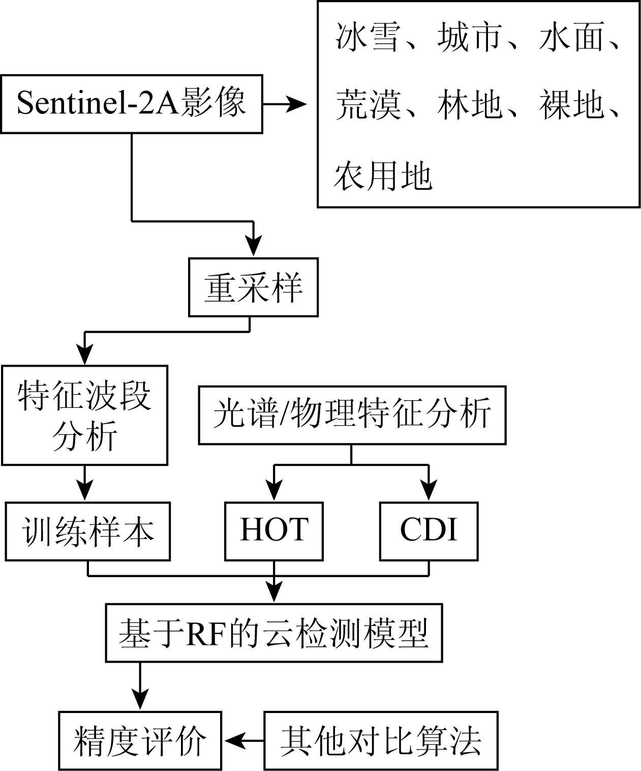
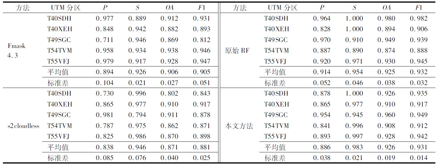
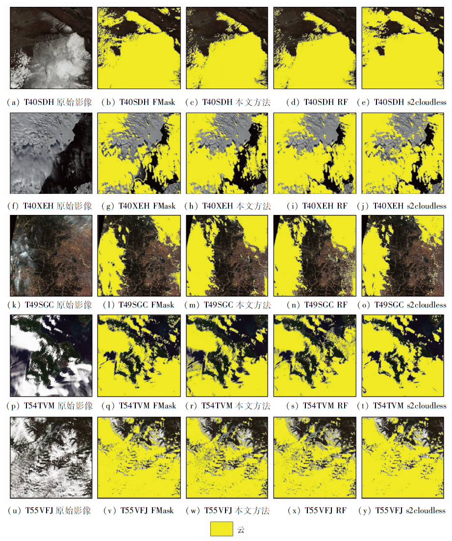
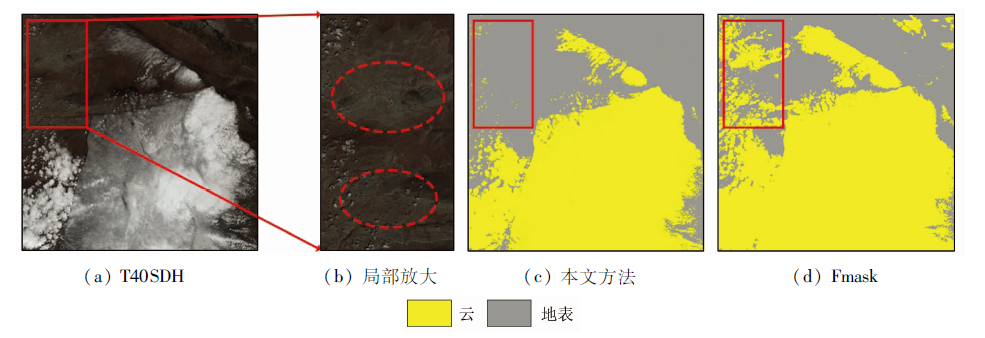
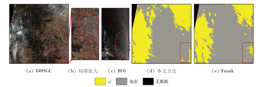
Abstract Cloud cover tends to hinder information extraction from remote sensing images during image processing. However, complex and changeable surface backgrounds make it difficult to effectively extract the differences in features between cloud targets and backgrounds. Although existing methods exhibit satisfactory cloud detection effects under most backgrounds, they show significant misclassification and omission in some environments, failing to maintain encouraging performance due to poor stability and insufficient generalization ability. Given this, this study proposed a cloud detection method for multiple backgrounds. Based on Sentinel-2A data, this study analyzed the differences in spectral characteristics between cloud targets and backgrounds to assist in the selection of samples for detection. Based on this, this study introduced more effective detection indices HOT and CDI. Finally, this study obtained a random forest-based cloud detection model through training. Then, from the perspective of the influence of backgrounds and cloud target types on detection accuracy, this study compared the obtained cloud detection model with the Fmask algorithm using images with different backgrounds. The comparison results show that the method proposed in this study increased the overall accuracy and F1 score by 2.2% and 2.9%, respectively, with the standard deviations of them reducing by 29.6% and 72.5%, respectively. These findings indicated that this method can significantly improve the stability of cloud detection in different environments while maintaining high detection accuracy. Therefore, this method is effective in cloud detection in multi-backgrounds.
|
| Keywords
Sentinel-2
cloud detection
random forest
Fmask
HOT
CDI
multi-background environment
|
|
|
|
Issue Date: 19 September 2023
|
|
|
| [1] |
Rossow W B, Duenas E N. The international satellite cloud climatology project (ISCCP) web site:An online resource for research[J]. Bulletin of the American Meteorological Society, 2004, 85(2):167-172.
doi: 10.1175/BAMS-85-2-173
url: https://journals.ametsoc.org/doi/10.1175/BAMS-85-2-173
|
| [2] |
Lu D, Weng Q. A survey of image classification methods and techniques for improving classification performance[J]. International Journal of Remote Sensing, 2007, 28(5):823-870.
doi: 10.1080/01431160600746456
url: https://www.tandfonline.com/doi/full/10.1080/01431160600746456
|
| [3] |
Zhu X, Helmer E H. An automatic method for screening clouds and cloud shadows in optical satellite image time series in cloudy regions[J]. Remote Sensing of Environment, 2018, 214:135-153.
doi: 10.1016/j.rse.2018.05.024
url: https://linkinghub.elsevier.com/retrieve/pii/S0034425718302530
|
| [4] |
彭龙康, 刘励聪, 陈学泓, 等. 遥感影像云检测网络泛化性能研究:以DeepLabv3+为例[J]. 遥感学报, 2021, 25(5):1169-1186.
|
| [4] |
Peng L K, Liu L C, Chen X H, et al. Generalization ability of cloud detection network for satellite imagery based on DeepLabv3+[J]. National Remote Sensing Bulletin, 2021, 25(5):1169-1186.
doi: 10.11834/jrs.20210061
url: http://www.ygxb.ac.cn/zh/article/doi/10.11834/jrs.20210061/
|
| [5] |
Coluzzi R, Imbrenda V, Lanfredi M, et al. A first assessment of the Sentinel-2 level 1-C cloud mask product to support informed surface analyses[J]. Remote Sensing of Environment, 2018, 217:426-443.
doi: 10.1016/j.rse.2018.08.009
url: https://linkinghub.elsevier.com/retrieve/pii/S0034425718303742
|
| [6] |
Hagolle O, Huc M, Pascual D V, et al. A multi-temporal method for cloud detection,applied to FORMOSAT-2,VENμS,LANDSAT and SENTINEL-2 images[J]. Remote Sensing of Environment, 2010, 114(8):1747-1755.
doi: 10.1016/j.rse.2010.03.002
url: https://linkinghub.elsevier.com/retrieve/pii/S0034425710000908
|
| [7] |
Main-Knorn M, Pflug B, Louis J, et al. Sen2Cor for Sentinel-2[C]// Image and Signal Processing for Remote Sensing XXIII.International Society for Optics and Photonics, 2017, 10427:37-48.
|
| [8] |
Qiu S, Zhu Z, He B. Fmask 4.0:Improved cloud and cloud shadow detection in Landsats4-8 and Sentinel-2 imagery[J]. Remote Sensing of Environment, 2019, 231:111205.
doi: 10.1016/j.rse.2019.05.024
url: https://linkinghub.elsevier.com/retrieve/pii/S0034425719302172
|
| [9] |
Fu H, Shen Y, Liu J, et al. Cloud detection for FY meteorology satellite based on ensemble thresholds and random forests approach[J]. Remote Sensing, 2019, 11(1):44.
doi: 10.3390/rs11010044
url: http://www.mdpi.com/2072-4292/11/1/44
|
| [10] |
栗旭升, 刘玉峰, 陈冬花, 等. 结合图像特征的支持向量机高分一号云检测[J]. 国土资源遥感, 2020, 32(3):55-62.doi:10.6046/gtzyyg.2020.03.08.
doi: 10.6046/gtzyyg.2020.03.08
|
| [10] |
Li X S, Liu Y F, Chen D H, et al. Cloud detection based on support vector machine with image features for GF-1 data[J]. Remote Sensing for Land and Resource, 2020, 32(3):55-62.doi:10.6046/gtzyyg.2020.03.08.
doi: 10.6046/gtzyyg.2020.03.08
|
| [11] |
Ishida H, Oishi Y, Morita K, et al. Development of a support vector machine based cloud detection method for MODIS with the adjustability to various conditions[J]. Remote Sensing of Environment, 2018, 205:390-407.
doi: 10.1016/j.rse.2017.11.003
url: https://linkinghub.elsevier.com/retrieve/pii/S0034425717305138
|
| [12] |
Cilli R, Monaco A, Amoroso N, et al. Machine learning for cloud detection of globally distributed Sentinel-2 images[J]. Remote Sensing, 2020, 12(15):2355.
doi: 10.3390/rs12152355
url: https://www.mdpi.com/2072-4292/12/15/2355
|
| [13] |
王明, 刘正佳, 陈元琰. 基于Sentinel-2波段/产品的图像云检测效果对比研究[J]. 遥感技术与应用, 2020, 35(5):1167-1177.
|
| [13] |
Wang M, Liu Z J, Chen Y Y. Comparsions of image cloud detection effect based on Sentinel-2 bands/products[J]. Remote Sensing Technology and Application, 2020, 35(5):1167-1177.
|
| [14] |
余长慧, 于海威, 张文, 等. 神经网络支持下的Sentinel-2卫星影像自动云检测[J]. 测绘通报, 2019(8):39-43.
doi: 10.13474/j.cnki.11-2246.2019.0248
|
| [14] |
Yu C H, Yu H W, Zhang W, et al. Automatic cloud detection of Sentinel-2 satellite images based on neural network[J]. Bulletin of Surveying and Mapping, 2019(8):39-43.
doi: 10.13474/j.cnki.11-2246.2019.0248
|
| [15] |
Hollstein A, Segl K, Guanter L, et al. Ready-to-use methods for the detection of clouds,cirrus,snow,shadow,water and clear sky pixels in Sentinel-2 MSI images[J]. Remote Sensing, 2016, 8(8):666.
doi: 10.3390/rs8080666
url: http://www.mdpi.com/2072-4292/8/8/666
|
| [16] |
Zhang Y, Guindon B, Cihlar J. An image transform to characterize and compensate for spatial variations in thin cloud contamination of Landsat images[J]. Remote Sensing of Environment, 2002, 82(2-3):173-187.
doi: 10.1016/S0034-4257(02)00034-2
url: https://linkinghub.elsevier.com/retrieve/pii/S0034425702000342
|
| [17] |
姜杰, 查勇, 袁杰, 等. 遥感技术在灰霾监测中的应用综述[J]. 环境监测管理与技术, 2011, 23(2):15-18.
|
| [17] |
Jiang J, Zha Y, Yuan J, et al. Application review of remote sensing technology in haze monitoring[J]. The Administration and Technique of Environmental Monitoring, 2011, 23(2):15-18.
|
| [18] |
Breiman L. Random forests[J]. Machine Learning, 2001, 45(1):5-32.
doi: 10.1023/A:1010933404324
url: http://link.springer.com/10.1023/A:1010933404324
|
| [19] |
Frantz D, Haß E, Uhl A, et al. Improvement of the Fmask algorithm for Sentinel-2 images:Separating clouds from bright surfaces based on parallax effects[J]. Remote Sensing of Environment, 2018, 215:471-481.
doi: 10.1016/j.rse.2018.04.046
url: https://linkinghub.elsevier.com/retrieve/pii/S0034425718302037
|
| [20] |
Pedregosa F, Varoquaux G, Gramfort A, et al. Scikit-learn:Machine learning in Python[J]. Journal of Machine Learning Research, 2011, 12:2825-2830.
|
| [21] |
Oshiro T M, Perez P S, Baranauskas J A. How many trees in a random forest?[C]// International Workshop on Machine Learning and Data Mining in Pattern Recognition.Springer,Berlin,Heidelberg, 2012:154-168.
|
| [22] |
Wei J, Huang W, Li Z, et al. Cloud detection for Landsat imagery by combining the random forest and superpixels extracted via energy-driven sampling segmentation approaches[J]. Remote Sensing of Environment, 2020, 248:112005.
doi: 10.1016/j.rse.2020.112005
url: https://linkinghub.elsevier.com/retrieve/pii/S0034425720303758
|
| [23] |
Zhu X, Helmer E H. An automatic method for screening clouds and cloud shadows in optical satellite image time series in cloudy regions[J]. Remote Sensing of Environment, 2018, 214:135-153.
doi: 10.1016/j.rse.2018.05.024
url: https://linkinghub.elsevier.com/retrieve/pii/S0034425718302530
|
| [24] |
Joachim L, Storch T. Cloud detection for night-time panchromatic visible and near-infrared satellite imagery[J]. ISPRS Annals of Photogrammetry,Remote Sensing and Spatial Information Sciences, 2020, 2:853-860.
|
| [25] |
Qiu S, He B, Zhu Z, et al. Improving Fmask cloud and cloud shadow detection in mountainous area for Landsats4-8 images[J]. Remote Sensing of Environment, 2017, 199:107-119.
doi: 10.1016/j.rse.2017.07.002
url: https://linkinghub.elsevier.com/retrieve/pii/S0034425717303073
|
|
Viewed |
|
|
|
Full text
|
|
|
|
|
Abstract
|
|
|
|
|
Cited |
|
|
|
|
| |
Shared |
|
|
|
|
| |
Discussed |
|
|
|
|
 2023,
Vol. 35
2023,
Vol. 35
 ), YE Fawang