|
|
|
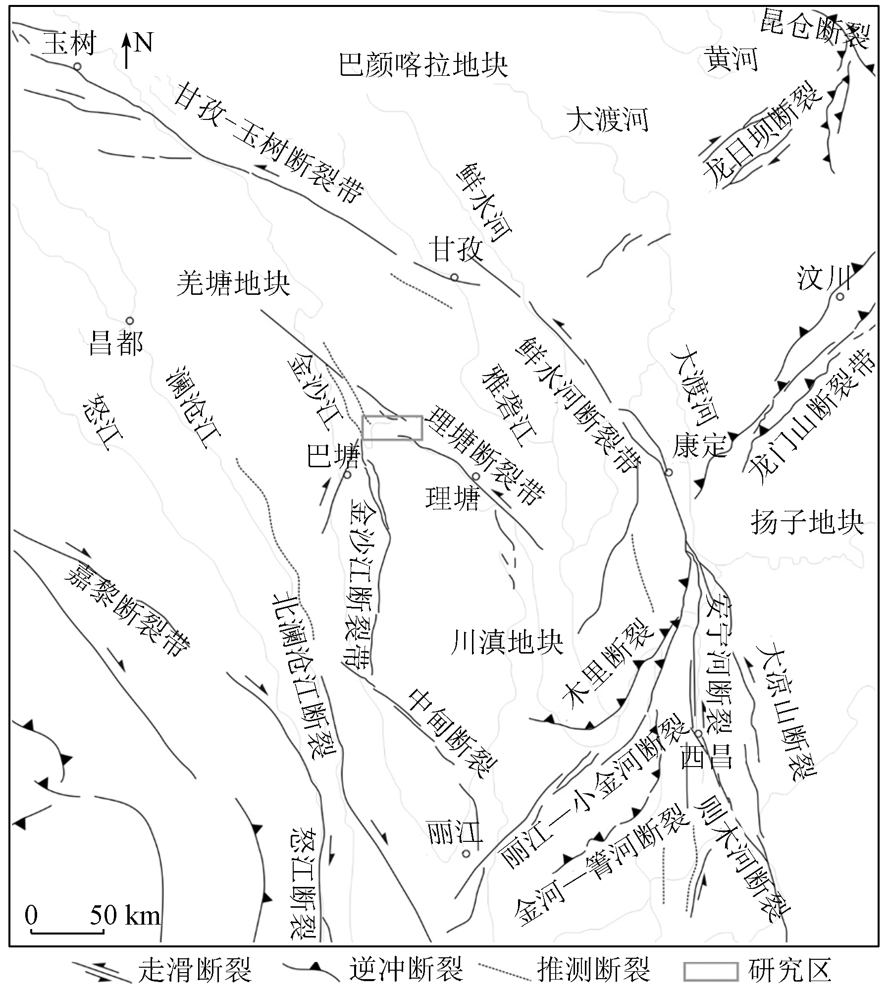
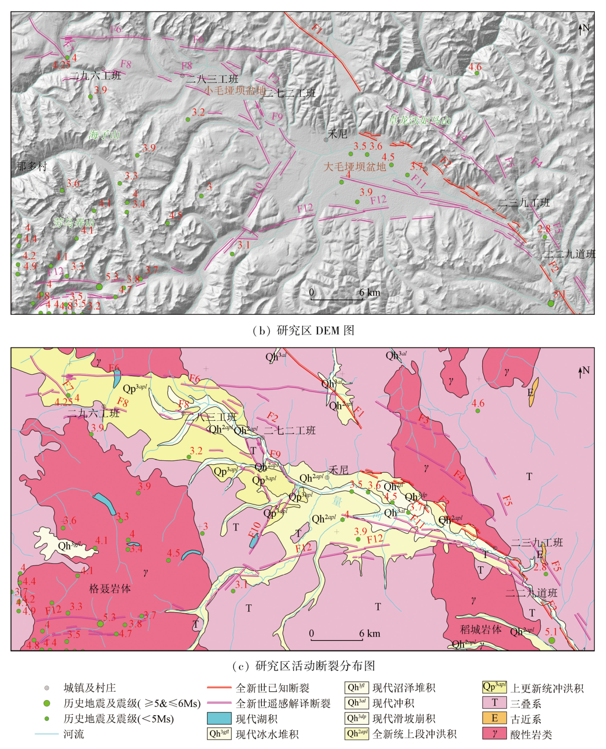
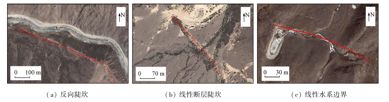
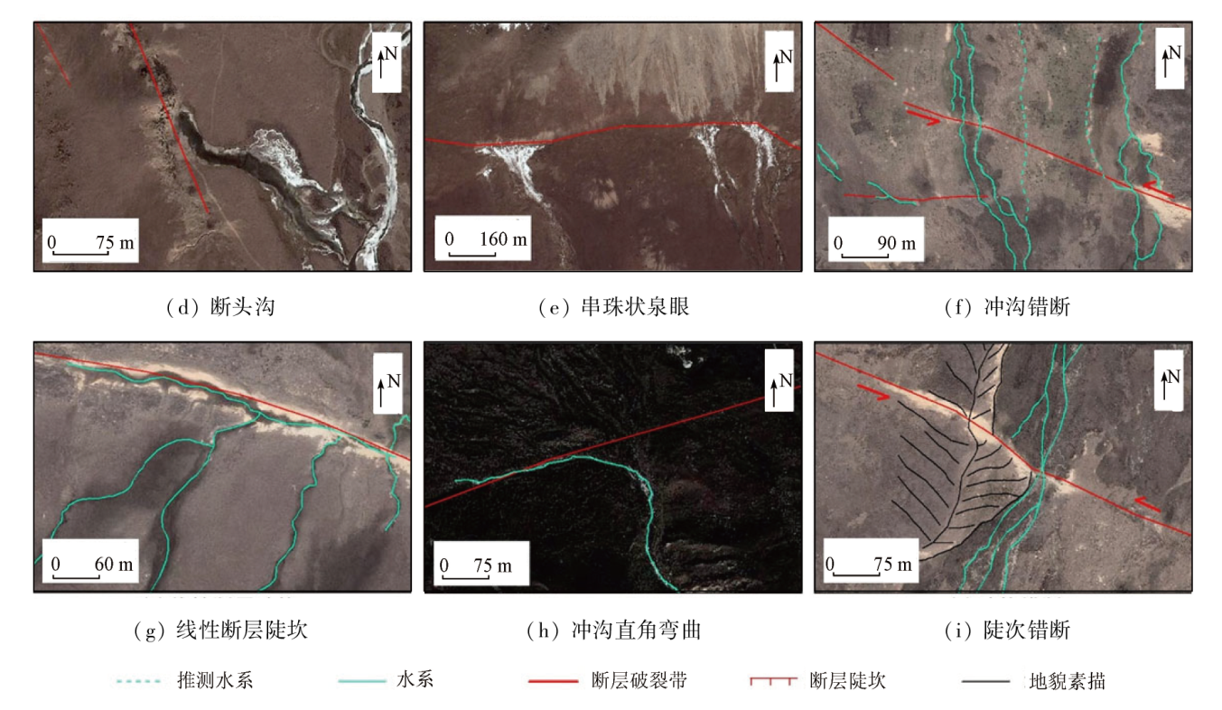
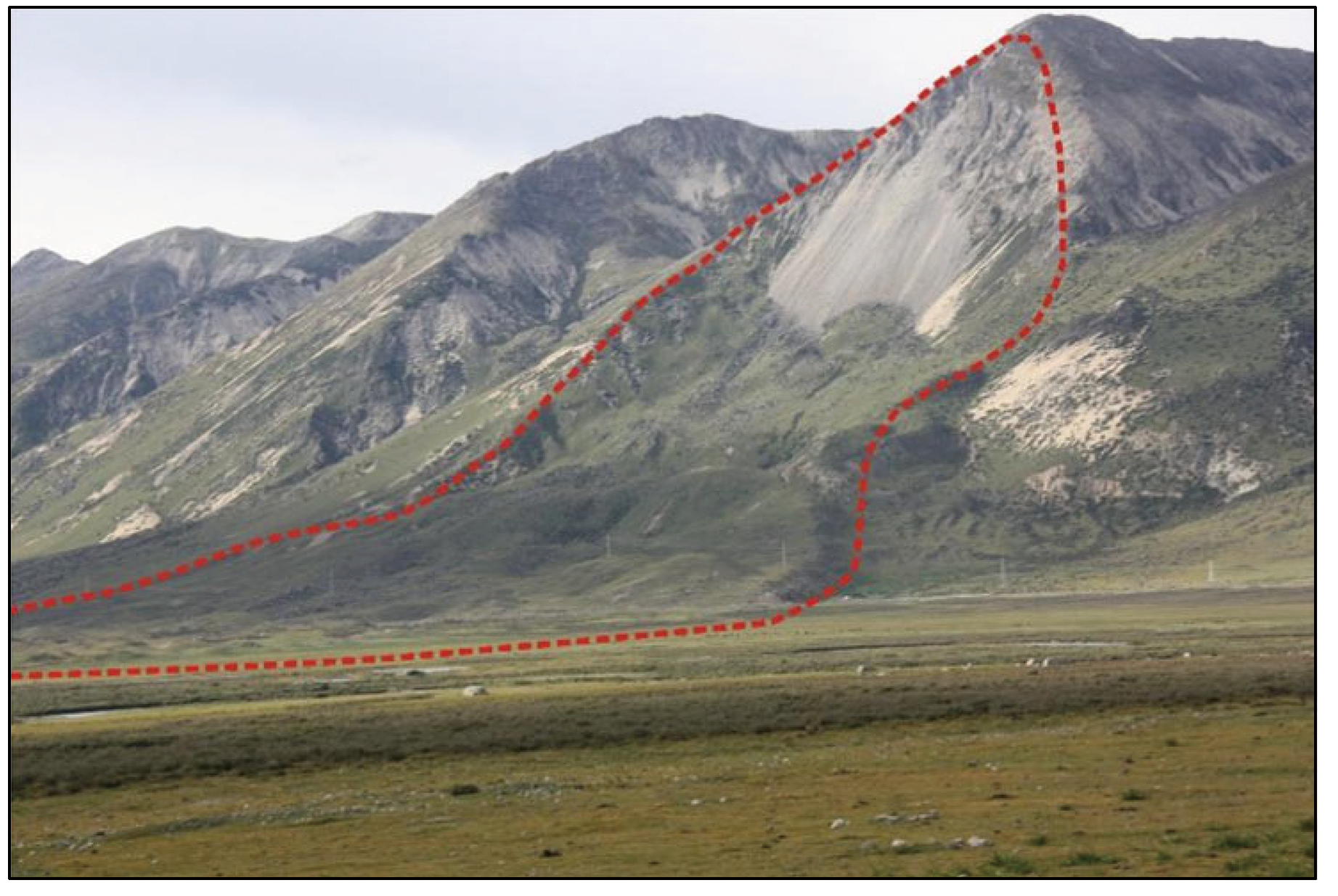
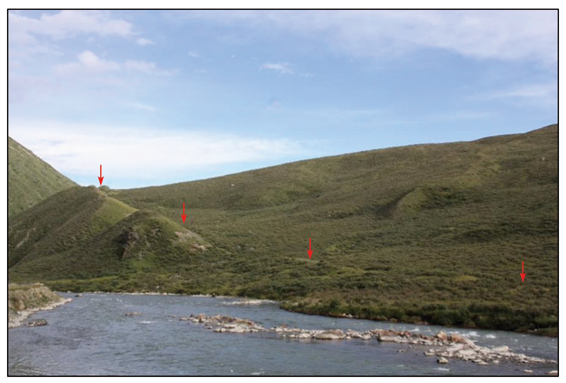
Abstract High-resolution remote sensing technology can greatly enhance the efficiency of investigations into active faults due to its high ability to identify the fine structures of microlandforms. This study presents a systematic summary of the symbols of remote sensing images for active faults. By comprehensively utilizing data from the Landsat8 and GF-2 satellites, as well as previous results and field geological surveys, this study analyzed and examined the active faults in the Maoyaba area of western Sichuan Province through the interpretation of remote sensing images of both macro- and microlandforms. The results show that, besides the Yidun-Litang fault zone, several nearly-W-E-trending normal active faults occur in the study area. Based on this finding, as well as the analysis of the regional geological setting, it can be concluded that crustal materials along the southeastern margin of the Qinghai-Tibet Plateau were continuously squeezed out laterally under the background of the intense collision and compression between the Indian and Eurasian plates, leading to the formation of two conjugate faults: the dextral Batang strike-slip fault and the sinistral Litang strike-slip fault. The joint control of both faults resulted in the local extension of the study area and the formation of nearly-W-E-trending fault structures, which govern the development and evolution of the Damaoyaba Basin, the Xiaomaoyaba Basin, and the Cuopu Basin in the north.
|
| Keywords
high-resolution remote sensing
interpretation symbol
Litang fault
active fault
Sichuan-Yunnan region
|
|
|
|
Issue Date: 03 September 2024
|
|
|
| [1] |
Arrowsmith J R, Zielke O. Tectonic geomorphology of the San Andreas fault zone from high resolution topography:An example from the Cholame segment[J]. Geomorphology, 2009, 113(1/2):70-81.
|
| [2] |
Klinger Y, Etchebes M, Tapponnier P, et al. Characteristic slip for five great earthquakes along the Fuyun fault in China[J]. Nature Geoscience, 2011, 4:389-392.
|
| [3] |
张景发, 姜文亮, 田甜, 等. 活动断裂调查中的高分辨率遥感技术应用方法研究[J]. 地震学报, 2016, 38(3):386-398,508.
|
| [3] |
Zhang J F, Jiang W L, Tian T, et al. High resolution remote sensing application research in active fault surveying[J]. Acta Seismologica Sinica, 2016, 38(3):386-398,508.
|
| [4] |
姜文亮, 张景发, 申旭辉, 等. 高分辨率遥感技术在活动断层研究中的应用[J]. 遥感学报, 2018, 22(s1):192-211.
|
| [4] |
Jiang W L, Zhang J F, Shen X H, et al. Geometric and geomorphic features of active fault structures interpreted from high-resolution remote sensing data[J]. National Remote Sensing Bulletin, 2018, 22(s1):192-211.
|
| [5] |
何宏林. 活动断层填图中的航片解译问题[J]. 地震地质, 2011, 33(4):938-950.
|
| [5] |
He H L. Some problems of aerial photo interpretation in active fault mapping[J]. Seismology and Geology, 2011, 33(4):938-950.
doi: 10.3969/j.issn.0253-4967.2011.04.017
|
| [6] |
邓起东. 中国活动构造研究的进展与展望[J]. 地质论评, 2002, 48(2):168-177.
|
| [6] |
Deng Q D. Advances and overview on researches of active tectonics in China[J]. Geological Review, 2002, 48(2):168-177.
|
| [7] |
邓起东, 陈立春, 冉勇康. 活动断裂定量研究与应用[J]. 地学前缘, 2004, 11(4):383-392.
|
| [7] |
Deng Q D, Chen L C, Ran Y K. Quantitative studies and applications of active tectonics[J]. Earth Science Frontiers, 2004, 11(4):383-392.
|
| [8] |
程佳, 徐锡伟, 甘卫军, 等. 青藏高原东南缘地震活动与地壳运动所反映的块体特征及其动力来源[J]. 地球物理学报, 2012, 55(4):1198-1212.
|
| [8] |
Cheng J, Xu X W, Gan W J, et al. Block model and dynamic implication from the earthquake activities and crustal motion in the southeastern margin of Tibetan Plateau[J]. Chinese Jourmal of Geophysics, 2012, 55(4):1198-1212.
|
| [9] |
王阎昭, 王恩宁, 沈正康, 等. 基于GPS资料约束反演川滇地区主要断裂现今活动速率[J]. 中国科学(D辑), 2008, 38(5):582-597.
|
| [9] |
Wang Y Z, Wang E N, Shen Z K, et al. Inversion of current active rate of main faults in Sichuan-Yunnan area based on GPS data constraints[J]. Science in China (Series D (Earth Sciences)), 2008, 38(5):582-597.
|
| [10] |
唐荣昌, 韩渭宾. 四川活动断裂与地震[M]. 北京: 地震出版社, 1993.
|
| [10] |
Tang R C, Han W B. Active faults and earthquakes in Sichuan Province[M]. Beijing: Seismological Press, 1993.
|
| [11] |
徐锡伟, 张培震, 闻学泽, 等. 川西及其邻近地区活动构造基本特征与强震复发模型[J]. 地震地质, 2005, 27(3):446-461.
|
| [11] |
Xu X W, Zhang P Z, Wen X Z, et al. Features of active tectonics and recurrence behaviors of strong earthquakes in the western Sichuan Province and its adjacent regions[J]. Seismology and Geology, 2005, 27(3):446-461.
|
| [12] |
周荣军, 陈国星, 李勇, 等. 四川西部理塘—巴塘地区的活动断裂与1989年巴塘6.7级震群发震构造研究[J]. 地震地质, 2005, 27(1):31-43.
|
| [12] |
Zhou R J, Chen G X, Li Y, et al. Research on active faults in Litang-Batang Region,western Sichuan Province,and the seismogenic structures of the 1989 Batang M6.7 earthquake swarm[J]. Seismology and Geology, 2005, 27(1):31-43.
|
| [13] |
周荣军, 叶友清, 李勇, 等. 理塘断裂带沙湾段的晚第四纪活动性[J]. 第四纪研究, 2007, 27(1):45-53.
|
| [13] |
Zhou R J, Ye Y Q, Li Y, et al. Late-quaternary activity of the Shawan segment of the Litang faults[J]. Quaternary Sciences, 2007, 27(1):45-53.
|
| [14] |
周春景, 吴中海, 张克旗, 等. 川西理塘活动断裂最新同震地表破裂形成时代与震级的重新厘定[J]. 地震地质, 2015, 37(2):455-467.
|
| [14] |
Zhou C J, Wu Z H, Zhang K Q, et al. New chronological constraint on the co-seismic surface rupture segments associated with the Litang fault[J]. Seismology and Geology, 2015, 37(2):455-467.
doi: 10.3969/j.issn.0253-4967.2015.02.009
|
| [15] |
侯增谦, 杨岳清, 曲晓明, 等. 三江地区义敦岛弧造山带演化和成矿系统[J]. 地质学报, 2004, 78(1):109-120.
|
| [15] |
Hou Z Q, Yang Y Q, Qu X M, et al. Tectonic evolution and mineralization systems of the yidun arc orogen in Sanjiang Region,China[J]. Acta Geologica Sinica, 2004, 78(1):109-120.
|
| [16] |
周荣军, 刘韶, 李勇, 等. 理塘断裂大毛垭坝—理塘段地震地表破裂与大地震复发间隔[C]. 中国地球科学联合学术年会论文集, 2016:677-678.
|
| [16] |
Zhou R J, Liu S, Li Y, et al. Earthquake surface rupture and recurrence interval of large earthquakes in Damaoyaba-Litang section of Litang fault[C]. Proceedings of Annual Meeting of Chinese Geoscience Unioin, 2016:677-678.
|
| [17] |
马丹, 吴中海, 李家存, 等. 川西理塘断裂带的空间展布与第四纪左旋走滑活动的遥感影像标志[J]. 地质学报, 2014, 88(8):1417-1435.
|
| [17] |
Ma D, Wu Z H, Li J C, et al. Geometric distribution and the quaternary activity of Litang active fault zone based on remote sensing[J]. Acta Geologica Sinica, 2014, 88(8):1417-1435.
|
| [18] |
赵国华. 川滇块体内理塘断裂活动性及其构造地貌研究[D]. 成都: 成都理工大学, 2014.
|
| [18] |
Zhao G H. Study on fault activity and tectonic geomorphology of Litang fault within the Chuandian Blocks[D]. Chengdu: Chengdu University of Technology, 2014.
|
| [19] |
张远泽. 川滇地块东部主要活动断裂新生代精确构造年代格架及其对青藏高原东缘新生代动力学过程的启示[D]. 武汉: 中国地质大学, 2015.
|
| [19] |
Zhang Y Z. Tectonic chronology constraint on the main faults bounding the East Sichuan-Yunnan Block and implications for Tibetan Plateau kinetics[D]. Wuhan: China University of Geosciences, 2015.
|
| [20] |
郭长宝, 杜宇本, 佟元清, 等. 青藏高原东缘理塘乱石包高速远程滑坡发育特征与形成机理[J]. 地质通报, 2016, 35(8):1332-1345.
|
| [20] |
Guo C B, Du Y B, Tong Y Q, et al. Huge long-runout landslide characteristics and formation mechanism:A case study of the Luanshibao landslide,Litang County,Tibetan Plateau[J]. Geological Bulletin of China, 2016, 35(8):1332-1345.
|
| [21] |
Chevalier M L, Leloup P H, Replumaz A, et al. Tectonic-geomorphology of the Litang fault system,SE Tibetan Plateau,and implication for regional seismic hazard[J]. Tectonophysics, 2016, 682:278-292.
|
| [22] |
张迪, 吴中海, 李家存, 等. 利用地面激光与地质雷达综合探测活断层浅层三维结构:以川西理塘毛垭坝盆地北缘正断层为例[J]. 地震地质, 2019, 41(2):377-399.
doi: 10.3969/j.issn.0253-4967.2019.02.008
|
| [22] |
Zhang D, Wu Z H, Li J C, et al. The delineation of three-dimensional shallow geometry of active fault based on TLS and GPR:A case study of a normal fault on the north margin of Maoyaba Basin in Litang,western Sichuan Province[J]. Seismology and Geology, 2019, 41(2):377-399.
|
| [23] |
曹云勇, 黄韬, 尹小康, 等. 川藏铁路理塘段毛垭坝盆地不良地质体浅层地震勘查[J]. 地球物理学进展, 2022, 37(2):774.
|
| [23] |
Cao Y Y, Huang T, Yin X K, et al. Shallow seismic explorations on unfavorable geological bodies in the Maoyaba Basin of the Litang section of the Sichuan-Tibet Railway[J]. Progress in Geophysics, 2022, 37(2):774.
|
| [24] |
Xu X W, Wen X Z, Yu G H, et al. Average slip rate,earthquake rupturing segmentation and recurrence behavior on the Litang fault zone,western Sichuan Province,China[J]. Science in China Series D Earth Sciences, 2005, 48(8):1183-1196.
|
| [25] |
刘亢, 李岩峰, 郭辉文, 等. 1948年川西理塘M7.3地震地表破裂特征及Riedel剪切构造分析[J]. 地质学报, 2021, 95(8):2346-2360.
|
| [25] |
Liu K, Li Y F, Guo H W, et al. Determination of surface rupture length and analysis of Riedel shear structure of the Litang M7.3 earthquake in west Sichuan in 1948[J]. Acta Geologica Sinica, 2021, 95(8):2346-2360.
|
| [26] |
张克旗, 吴中海, 周春景, 等. 川西理塘断裂带奔戈-村戈段古地震事件及其非均匀性活动特征[J]. 地质学报, 2020, 94(4):1295-1303.
|
| [26] |
Zhang K Q, Wu Z H, Zhou C J, et al. Paleo earthquake events and inhomogeneous activity characteristics in the Benge- Cunge section of the Litang fault zone in the western Sichuan Province[J]. Acta Geologica Sinica, 2020, 94(4):1295-1303.
|
| [27] |
任俊杰, 徐锡伟, 康文君, 等. 理塘断裂带毛垭坝断裂全新世古地震历史与大震复发行为[C]// 2020年中国地球科学联合学术年会论文集, 2020:24.
|
| [27] |
RenJ J, XuX W, KangW J, et al. Holocene paleoearthquake history and large earthquake recurrence behavior of Maoyaba fault in Litang fault zone[C]// Proceedings of Annual Meeting of Chinese Geoscience Unioin, 2020:24.
|
| [28] |
Holt W E, Ni J F, Wallace T C, et al. The active tectonics of the eastern Himalayan syntaxis and surrounding regions[J]. Journal of Geophysical Research:Solid Earth, 1991, 96(B9):14595-14632.
|
| [29] |
Wang E, Burchfiel B C. Interpretation of Cenozoic tectonics in the right-lateral accommodation zone between the Ailao Shan shear zone and the eastern Himalayan syntaxis[J]. International Geology Review, 1997, 39:191-219.
|
| [30] |
张培震, 王琪, 马宗晋. 青藏高原现今构造变形特征与GPS速度场[J]. 地学前缘, 2002, 9(2):442-450.
|
| [30] |
Zhang P Z, Wang Q, Ma Z J. GPS velocity field and active crustal deformation in and around the Qinghai-Tibet Plateau[J]. Earth Science Frontiers, 2002, 9(2):442-450.
|
| [31] |
Socquet A, Pubellier M. Cenozoic deformation in western Yunnan (China-Myanmar border)[J]. Journal of Asian Earth Sciences, 2005, 24(4):495-515.
|
| [32] |
吴中海, 龙长兴, 范桃园, 等. 青藏高原东南缘弧形旋扭活动构造体系及其动力学特征与机制[J]. 地质通报, 2015, 34(01):1-31.
|
| [32] |
Wu Z H, Long C X, Fan T Y, et al. The arc rotational-shear active tectonic system on the southeastern margin of Tibetan Plateau and its dynamic characteristics and mechanism[J]. Geological Bulletin of China, 2015, 34(1):1-31.
|
| [33] |
Gan W J, Zhang P Z, Shen Z K, et al. Present-day crustal motion within the Tibetan Plateau inferred from GPS measurements[J]. Journal of Geophysical Research:Solid Earth, 2007, 112(B8):B08416.
|
| [34] |
张清林. 川西巴塘地区断裂构造变形研究[D]. 成都: 成都理工大学, 2016.
|
| [34] |
Zhang Q L. Study on deformation of faults in Batang region in Western Sichuan[D]. Chengdu: Chengdu University of Technology, 2016.
|
|
Viewed |
|
|
|
Full text
|
|
|
|
|
Abstract
|
|
|
|
|
Cited |
|
|
|
|
| |
Shared |
|
|
|
|
| |
Discussed |
|
|
|
|
 2024,
Vol. 36
2024,
Vol. 36
 ), SONG Yuanbao, ZHANG Wei, YUAN Huayun