|
|
 |
|

|
|
|
Remote sensing image interpretation and tectonic activity study of the active faults along the northeastern segment of the Longmenshan fault |
Xiaoping XIE1, Maowei BAI1( ), Zhicong CHEN1, Weibo LIU2, Shuna XI3 ), Zhicong CHEN1, Weibo LIU2, Shuna XI3 |
1.School of Geography and Tourism, Qufu Normal University, Rizhao 276826, China
2.Geochemical Exploration Party, Sichuan Bureau of Exploration and Development of Geology and Minerals Resources, Deyang 618000, China
3.Institute of Geological Relics, No. 137 Geological Party, Sichuan Coalfield Geological Bureau, Chengdu 610000, China |
|
|
|
|
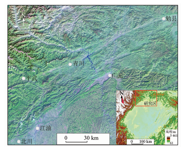
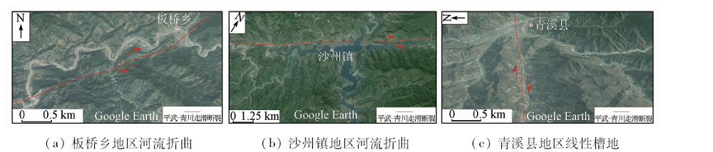
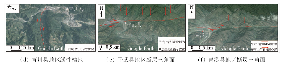
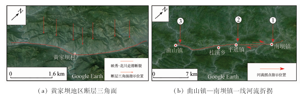
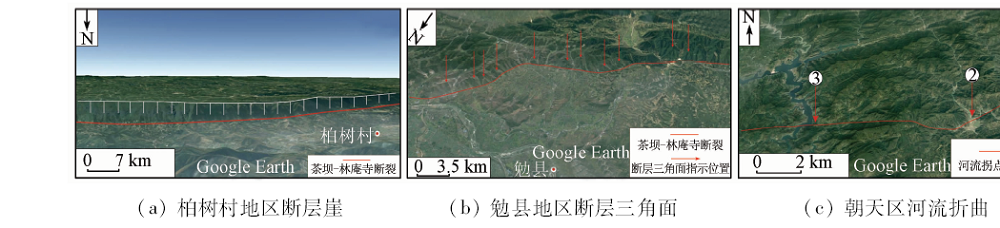
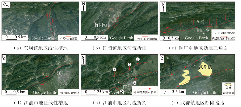
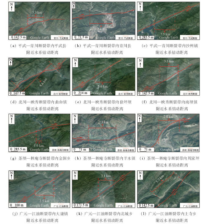
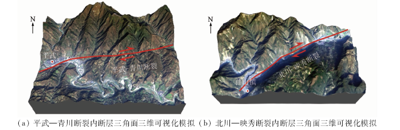
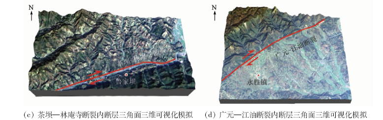
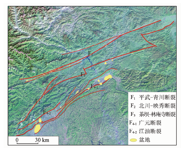
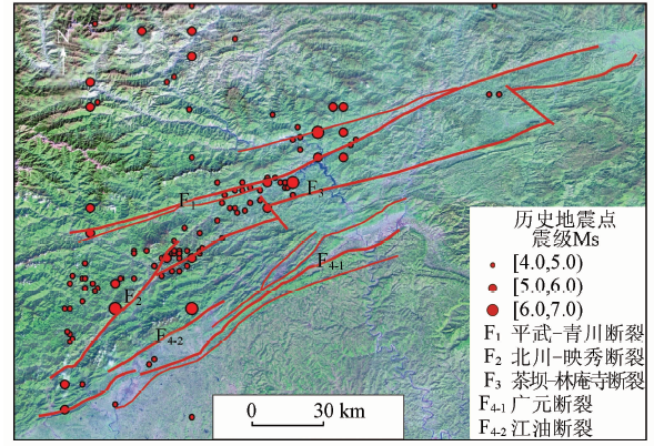
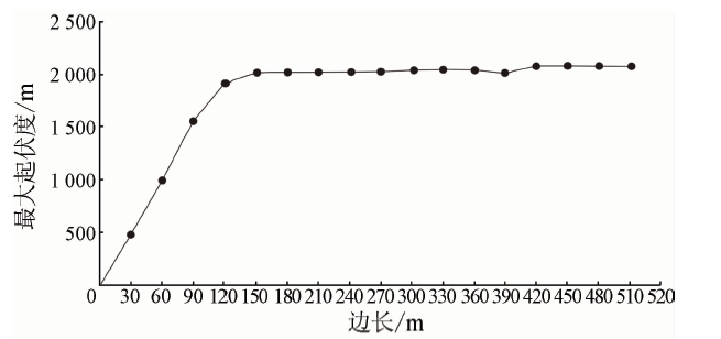
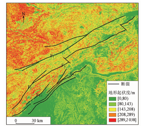
Abstract In this paper, the authors systematically summarized the remote sensing interpretation signs of active faults and, by using Landsat ETM+, ASTER GDEM and Google Earth image data in combination with previous research results, obtained the spatial distribution of active faults in the study area and analyzed in detail fault properties and activities. It is shown that Pingwu — Qingchuan fault, the northeastern segment of Beichuan — Yingxiu fault, Chaba — Linansi fault and Guangyuan — Jiangyou fault are roughly parallel in spatial distribution. On the basis of the measurement of offset streams dislocation, the contrast of exaggerated 3D landforms, the historical earthquakes analysis and the analysis of topographic relief extent of land surface, the authors have reached the conclusion that Pingwu — Qingchuan fault, the northeastern segment of Beichuan — Yingxiu fault, Chaba — Linansi fault and Guangyuan — Jiangyou fault are main active faults in the zone, which are all right-lateral strike-slip and thrust faults. Among them, the activity of the Pingwu — Qingchuan fault is strongest, the activity of the the northeastern segment of Beichuan — Yingxiu fault and Chaba — Linansi fault is weaker than that of Pingwu — Qingchuan fault, and the activity of the Guangyuan — Jiangyou fault is the weakest.
|
| Keywords
remote sensing interpretation
active fault zone
fault activity
the northeastern segment of the Longmenshan fault zone
|
|
|
|
Corresponding Authors:
Maowei BAI
E-mail: 17863349965@163.com
|
|
Issue Date: 14 March 2019
|
|
|
| [1] |
吴中海, 张岳桥, 胡道功 . 新构造、活动构造与地震地质[J]. 地质通报, 2014,33(4):391-402.
doi: 10.3969/j.issn.1671-2552.2014.04.001
url: http://www.cqvip.com/QK/95894A/201404/49440338.html
|
| [1] |
Wu Z H, Zhang Y Q, Hu D G . Neotectonics,active tectonics and earthquake geology[J]. Geological Bulletin of China, 2014,33(4):391-402.
|
| [2] |
Molnar P, Tapponnier P . Cenozoic tectonics of Asia:Effects of a continental collision[J]. Science, 1975,189(4201):419-426.
doi: 10.1126/science.189.4201.419
pmid: 17781869
url: http://www.sciencemag.org/cgi/doi/10.1126/science.189.4201.419
|
| [3] |
Taylor M, Yin A . Active structures of the Himalayan-Tibetan orogen and their relationships to earthquake distribution,contemporary strain field, and Cenozoic volcanism[J]. Geosphere, 2009,5(3):199-214.
doi: 10.1130/GES00217.1
url: http://pubs.geoscienceworld.org/geosphere/article/5/3/199/31257/Active-structures-of-the-HimalayanTibetan-orogen
|
| [4] |
张培震, 邓起东, 张竹琪 , 等. 中国大陆的活动断裂、地震灾害及其动力过程[J]. 中国科学(地球科学), 2013,43(10):1607-1620.
url: http://www.cnki.com.cn/Article/CJFDTotal-JDXK201310005.htm
|
| [4] |
Zhang P Z, Deng Q D, Zhang Z Q , et al. Active faults,earthquake hazards and associated geodynamic processes in continental China[J]. Scientia Sinica Terrae, 2013,43(10):1607-1620.
|
| [5] |
Chen Z H, Burchfiel B C, Liu Y , et al. Global positioning system measurements from eastern Tibet and their implications for India/Eurasia implications for India/Eurasia intercontinental deformation[J]. Journal of Geophysical Research(Solid Earth), 2000,105(b7):16215-16227.
|
| [6] |
Fu B H, Awata Y . Displacement and timing of left-lateral faulting in the Kunlun Fault Zone, northern Tibet,inferred from geologic and geomorphic features[J]. Journal of Asian Earth Sciences, 2007,29(2):253-265.
doi: 10.1016/j.jseaes.2006.03.004
url: https://linkinghub.elsevier.com/retrieve/pii/S1367912006000770
|
| [7] |
李勇, 周荣军 , Densmore A L, 等. 青藏高原东缘龙门山晚新生代走滑-逆冲作用的地貌标志[J]. 第四纪研究, 2006,26(1):40-51.
doi: 10.3321/j.issn:1001-7410.2006.01.006
url: http://d.old.wanfangdata.com.cn/Periodical/dsjyj200601006
|
| [7] |
Li Y, Zhou R J, Densmore A L , et al. Geomorphic evidence for the late cenozoic strike-slipping and thrusting in Longmen mountain at the eastern margin of the Tibetan Plateau[J]. Quaternary Sciences, 2006,26(1):40-51.
|
| [8] |
李勇, 周荣军 , Densmore A L, 等. 青藏高原东缘龙门山晚新生代走滑挤压作用的沉积响应[J]. 沉积学报, 2006,24(2):153-164.
doi: 10.3969/j.issn.1000-0550.2006.02.001
url: http://d.wanfangdata.com.cn/Periodical/cjxb200602001
|
| [8] |
Li Y, Zhou R J, Densmore A L , et al. Sedimentary responses to late Cenozoic thrusting and strike-slipping of Longmen Shan along eastern margin of Tibetan Plateau[J]. Acta Sedimentologica Sinica, 2006,24(2):153-164.
|
| [9] |
付碧宏, 时丕龙, 张之武 . 四川汶川MS8.0大地震地表破裂带的遥感影像解析[J]. 地质学报, 2008,82(12):1679-1687.
doi: 10.3321/j.issn:0001-5717.2008.12.005
url: http://www.cnki.com.cn/Article/CJFDTotal-DZXE200812007.htm
|
| [9] |
Fu B H, Shi P L, Zhang Z W . Spatial characteristics of the surface rupture produced by the MS8.0 Wenchuan earthquake using high-resolution remote sensing imagery[J]. Acta Geologica Sinica, 2008,82(12):1679-1687.
|
| [10] |
路静, 张景发, 姜文亮 , 等. 龙门山断裂带北段活动特征的遥感地质解译研究[J]. 地震, 2009,29(b10):164-172.
doi: 10.3969/j.issn.1000-3274.2009.z1.022
url: http://d.wanfangdata.com.cn/Periodical/diz2009z1022
|
| [10] |
Lu J, Zhang J F, Jian W L , et al. Interpretation of active tectonics along the northern segment of the Longmenshan fault zone from RS images[J]. Earthquake, 2009,29(b10):164-172.
|
| [11] |
李勇, 黎兵, 周荣军 , 等. 剥蚀-沉积体系中剥蚀量与沉积通量的定量对比研究——以岷江流域为例[J]. 地质学报, 2007,81(3):332-343.
doi: 10.3321/j.issn:0001-5717.2007.03.006
url: http://d.wanfangdata.com.cn/Periodical/dizhixb200703006
|
| [11] |
Li Y, Li B, Zhou R J , et al. The quantitative correlation between denudation volume and flux in the denudation-accumulation system:Examples from Minjiang River drainage system[J]. Acta Geologica Sinica, 2007,81(3):332-343.
|
| [12] |
杨农, 张岳桥 . 龙门山断裂活动和川西高原隆升历史的裂变径迹测年[J]. 地质力学学报, 2010,16(4):359-371.
doi: 10.3969/j.issn.1006-6616.2010.04.004
url: http://www.cnki.com.cn/Article/CJFDTotal-DZLX201004005.htm
|
| [12] |
Yang N, Zhang Y Q . Tission-track dating for activity of the Longmenshan fault zone and uplifting of the western Sichuan Plateau[J]. Journal of Geomechanics, 2010,16(4):359-371.
|
| [13] |
侯增谦, 吕庆田, 王安建 , 等. 初论陆-陆碰撞与成矿作用——以青藏高原造山带为例[J]. 矿床地质, 2003,22(4):319-333.
doi: 10.3969/j.issn.0258-7106.2003.04.001
url: http://www.cqvip.com/Main/Detail.aspx?id=8700709
|
| [13] |
Hou Z Q, Lyu Q T, Wang A J , et al. Continental collision and related metallogeny:A case study of mineralization in Tibetan orogen[J]. Mineral Deposits, 2003,22(4):319-333.
|
| [14] |
李勇, 孙爱珍 . 龙门山造山带构造地层学研究[J]. 地层学杂志, 2000,24(3):201-206.
doi: 10.3969/j.issn.0253-4959.2000.03.006
url: http://www.cnki.com.cn/Article/CJFDTotal-DCXZ200003005.htm
|
| [14] |
Li Y, Sun A Z . Tectostratigraphy of Longmenshan orogen[J]. Journal of Stratigrephy, 2000,24(3):201-206.
|
| [15] |
高名修 . 晚新生代地壳构造运动研究[J]. 地质力学学报, 2008,14(4):295-319.
doi: 10.3969/j.issn.1006-6616.2008.04.001
url: http://www.cnki.com.cn/Article/CJFDTotal-DZLX200804001.htm
|
| [15] |
Gao M X . Study on late Cenozoic crustal tectonism[J]. Journal of Geomechanics, 2008,14(4):295-319.
|
| [16] |
李玶, 汪良谋 . 云南川西地区地震地质基本特征的探讨[J]. 地质科学, 1975,10(4):308-326.
url: http://www.cnki.com.cn/Article/CJFDTotal-DZKX197504001.htm
|
| [16] |
Li P, Wang L M . Exploration of the seismo-geological features of the Yunnan-West Sichuan Region[J]. Scientia Geological Sinica, 1975,10(4):308-326.
|
| [17] |
Tapponnier P, Peltzer G, Le Dain A Y, et al. Propagating extrusion tectonics in Asia:New insights from simple experiments with plasticine[J]. Geology, 1982,10(12):611-616.
doi: 10.1130/0091-7613(1982)10<611:PETIAN>2.0.CO;2
url: https://pubs.geoscienceworld.org/geology/article/10/12/611-616/203380
|
| [18] |
付碧宏, 时丕龙, 王萍 , 等. 2008年汶川地震断层北川段的几何学与运动学特征及地震地质灾害效应[J]. 地球物理学报, 2009,52(2):485-495.
doi:
url: http://d.wanfangdata.com.cn/Periodical/dqwlxb200902020
|
| [18] |
Fu B H, Shi P L, Wang P , et al. Geometry and kinematics of the 2008 Wenchuan earthquake surface ruptures around the Qushan Town of Beichuan County,Sichuan:Implications for mitigation of seismic and geologic disasters[J]. Chinese Journal of Geophysics, 2009,52(2):485-495.
|
| [19] |
Fu B H, Shi P L, Guo H D , et al. Surface deformation related to the 2008 Wenchuan earthquake,and mountain building of the Longmen Shan,eastern Tibetan Plateau[J]. Journal of Asian Earth Sciences, 2011,40(4):805-824.
doi: 10.1016/j.jseaes.2010.11.011
url: https://linkinghub.elsevier.com/retrieve/pii/S1367912010003366
|
| [20] |
李智武, 刘树根, 陈洪德 , 等. 龙门山冲断带分段-分带性构造格局及其差异变形特征[J]. 成都理工大学学报(自然科学版), 2008,35(4):440-454.
doi: 10.3969/j.issn.1671-9727.2008.04.014
url: http://d.wanfangdata.com.cn/Periodical/cdlgxyxb200804014
|
| [20] |
Li Z W, Liu S G, Chen H D , et al. Structural segmentation and zonation and differential deformation across and along the Lomgmen thrust belt,West Sichuan,China[J]. Journal of Chengdu University of Technology(Science and Technology Edition), 2008,35(4):440-454.
|
| [21] |
金文正, 汤良杰, 杨克明 , 等. 川西龙门山褶皱冲断带分带性变形特征[J]. 地质学报, 2007,81(8):1072-1080.
doi: 10.3321/j.issn:0001-5717.2007.08.007
url: http://www.cqvip.com/Main/Detail.aspx?id=25708793
|
| [21] |
Jin W Z, Tang L J, Yang K M , et al. Deformation and zonation of the Longmenshan fold and thrust zone in the Western Sichuan Basin[J]. Acta Geologica Sinica, 2007,81(8):1072-1080.
|
| [22] |
Liu S F, Qian T, Li W P , et al. Oblique closure of the northeastern Paleo-Tethys in central China[J]. Tectonics, 2015,34(3):413-434.
doi: 10.1002/2014TC003784
url: http://doi.wiley.com/10.1002/2014TC003784
|
| [23] |
贾营营, 付碧宏, 王岩 , 等. 青藏高原东缘龙门山断裂带晚新生代构造地貌生长及水系响应[J]. 第四纪研究, 2010,30(4):825-836.
doi: 10.3969/j.issn.1001-7410.2010.04.17
url: http://d.wanfangdata.com.cn/Periodical/dsjyj201004017
|
| [23] |
Jia Y Y, Fu B H, Wang Y , et al. Late Cenozoic tectono-geomorphic growth and drainage response in the Longmen Shan fault zone,east margin of Tibet[J]. Quaternary Science, 2010,30(4):825-836.
|
| [24] |
李勇, 周荣军 , Densmore A L, 等. 青藏高原东缘大陆动力学过程与地质响应[M]. 北京: 地质出版社, 2006.
|
| [24] |
Li Y, Zhou R J, Densmore A L , et al. The Response of Geological and Progress of Continental Dynamics of the Eastern Margin Tibetan Plateau[M]. Beijing: Geological Press, 2006.
|
| [25] |
Densemore A L, Ellis M, Li Y , et al. Active tectonics of the Beichuan and Pengguan faults at the eastern margin of the Tibetan Plateau[J]. Tectonics, 2007, 26(4):TC4005,1-17.
doi: 10.1029/2006TC001987
url: http://onlinelibrary.wiley.com/doi/10.1029/2006TC001987/pdf
|
| [26] |
白毛伟, 谢小平, 陈芝聪 , 等. 龙门山北东段山前涪江第四纪冲洪积扇地貌演化及其构造响应[J]. 沉积学报, 2017,35(1):85-92.
doi: 10.14027/j.cnki.cjxb.2017.01.009
url: http://d.wanfangdata.com.cn/Periodical/cjxb201701009
|
| [26] |
Bai M W, Xie X P, Chen Z C , et al. Geomorphological evolution of the Quaternary alluvial fans and its response to tectonic activity along the Fujiang River,northeastern Longmen Shan[J]. Acta Sedimentologica Sinica, 2017,35(1):85-92.
|
| [27] |
刘振东, 涂汉明 . 中国地势起伏度统计单元的初步研究[J]. 热带地理, 1989,9(1):31-38.
url: http://www.cnki.com.cn/Article/CJFDTotal-RDDD198901004.htm
|
| [27] |
Liu Z D, Tu H M . Study on statistical unit of relief amplitude in China[J]. Tropical Geography, 1989,9(1):31-38.
|
| [28] |
涂汉明, 刘振东 . 中国地势起伏度最佳统计单元的求证[J]. 湖北大学学报(自然科学版), 1990,12(3):266-271.
url: http://www.cqvip.com/QK/96466X/199003/279526.html
|
| [28] |
Tu H M, Liu Z D . Demonstrating on optimum statistic unit of relief amplitude in China[J]. Journal of Hubei University(Nature Science), 1990,12(3):266-271.
|
| [29] |
陈立春, 陈杰, 刘进峰 , 等. 龙门山前山断裂北段晚第四纪活动性研究[J]. 地震地质, 2008,30(3):710-722.
doi: 10.3969/j.issn.0253-4967.2008.03.010
url: http://www.cqvip.com/Main/Detail.aspx?id=28330110
|
| [29] |
Chen L C, Chen J, Liu J F , et al. Investigation of late Quaternary activity along the northern range front fault,Longmenshan[J]. Seismology and Geology, 2008,30(3):710-722.
|
|
Viewed |
|
|
|
Full text
|
|
|
|
|
Abstract
|
|
|
|
|
Cited |
|
|
|
|
| |
Shared |
|
|
|
|
| |
Discussed |
|
|
|
|
 2019,
Vol. 31
2019,
Vol. 31