|
|
|
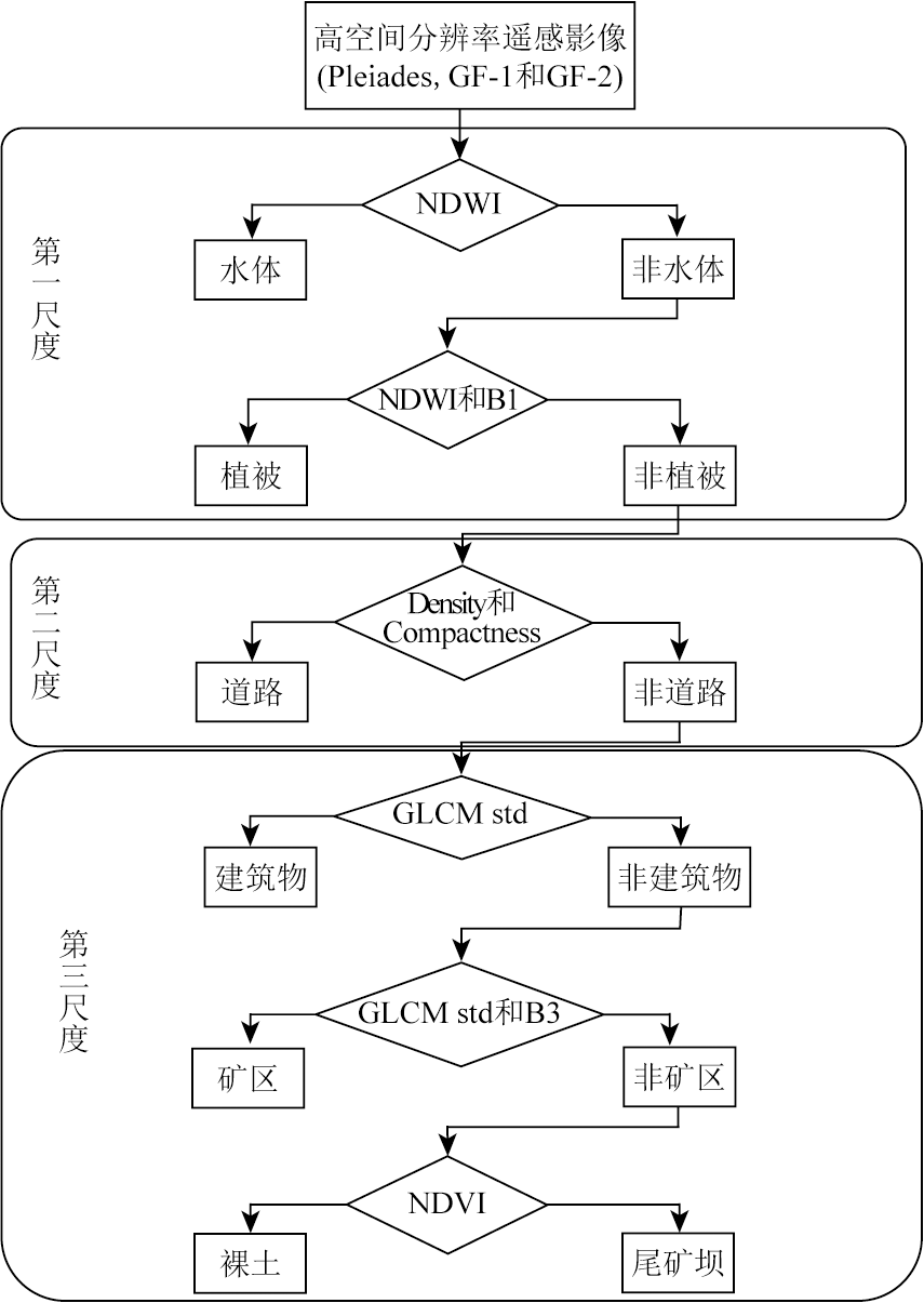
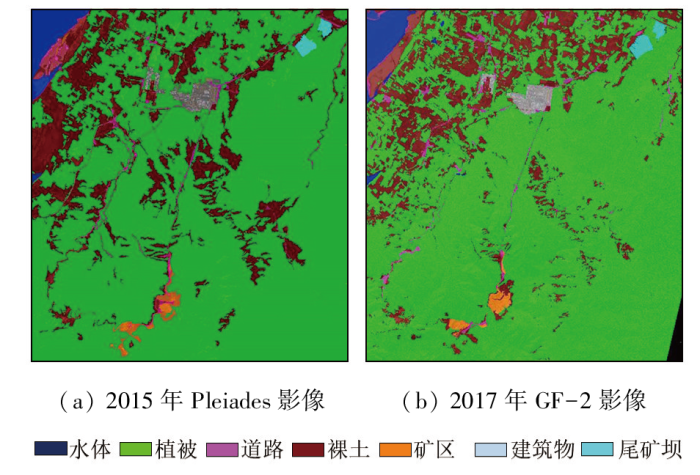
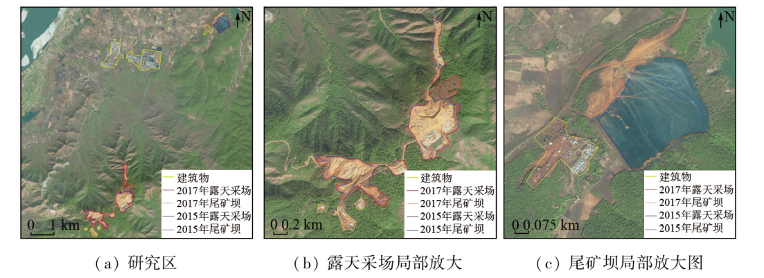
Abstract High-resolution remote sensing images have been widely applied to classification of ore deposits. However, there is a lack of studies on the information extraction and dynamic monitoring of open-pit lateritic nickel deposits. Using high-resolution remote sensing images from the Pleiades and GF-2 satellites, this study investigated the famous open-pit Tagaung Taung nickel deposit in Myanmar. First, information about surface features was extracted using object-oriented classification based on hierarchical multi-scale segmentation. Then, the dynamic changes in the nickel deposit were analyzed. Finally, qualitative and quantitative assessments of the classification accuracy were carried out. The results indicate that the hierarchical multi-scale segmentation technology exhibited encouraging classification and identification effects, with overall classification accuracy of 94.24% and 89.02% and the Kappa coefficients of 0.889 and 0.816, respectively for images from the Pleiades and GF-2 satellites. Therefore, the proposed method is suitable for the information extraction of open-pit lateritic nickel deposits. The dynamic change analysis reveals that the Tagaung Taung nickel deposit experienced continuous expansion of mining at high mining speeds from 2015 to 2017. It can be inferred that this deposit has great potential and broad prospects for resource development. The results of this study can provide technical support for the dynamic monitoring of the Tagaung Taung nickel deposit in Myanmar.
|
| Keywords
hierarchical multi-scale segmentation
information extraction
dynamic monitoring for changes
nickel deposit
|
|
|
|
Issue Date: 23 December 2024
|
|
|
| [1] |
Upadhyay P, Ghosh S K, Kumar A, et al. Effect on specific crop mapping using WorldView-2 multispectral add-on bands:Soft classification approach[J]. Journal of Applied Remote Sensing, 2012, 6(1):063524.
|
| [2] |
Mutanga O, Adam E, Cho M A. High density biomass estimation for wetland vegetation using WorldView-2 imagery and random forest regression algorithm[J]. International Journal of Applied Earth Observation and Geoinformation, 2012, 18:399-406.
|
| [3] |
Pacifici F, Chini M, Emery W J. A neural network approach using multi-scale textural metrics from very high-resolution panchromatic imagery for urban land-use classification[J]. Remote Sensing of Environment, 2009, 113(6):1276-1292.
|
| [4] |
Longbotham N, Chaapel C, Bleiler L, et al. Very high resolution multiangle urban classification analysis[J]. IEEE Transactions on Geoscience and Remote Sensing, 2011, 50(4):1155-1170.
|
| [5] |
高俊华, 邹联学, 龙欢, 等. 基于遥感动态监测的吉林省矿山地质环境及生态修复变化特征分析[J]. 自然资源遥感, 2022, 34(3):240-248.doi:10.6046/zrzyyg.2021278.
|
| [5] |
Gao J H, Zou L X, Long H, et al. Analysis on characteristics of mine geological environment and ecological restoration changes in Jilin Province based on dynamic remote sensing monitoring[J]. Remote Sensing for Natural Resources, 2022, 34(3):240-248.doi:10.6046/zrzyyg.2021278.
|
| [6] |
汪洁, 刘小杨, 杨金中, 等. 基于国产高空间分辨率卫星数据的浙江省矿山环境恢复治理典型模式分析[J]. 国土资源遥感, 2020, 32(3):216-221.doi:10.6046/gtzyyg.2020.03.28.
|
| [6] |
Wang J, Liu X Y, Yang J Z, et al. Typical model analysis of mine geological environment restoration and management in Zhejiang Province based on domestic high-resolution satellite data[J]. Remote Sensing for Land and Resources, 2020, 32(3):216-221.doi:10.6046/gtzyyg.2020.03.28.
|
| [7] |
王海庆, 郝建亭, 李丽, 等. 西藏各行政区矿产开采强度遥感分析[J]. 国土资源遥感, 2020, 32(1):115-119.doi:10.6046/gtzyyg.2020.01.16.
|
| [7] |
Wang H Q, Hao J T, Li L, et al. Mining intensity analysis of each administrative region in Tibet based on remote sensing[J]. Remote Sensing for Land and Resources, 2020, 32(1):115-119.doi:10.6046/gtzyyg.2020.01.16.
|
| [8] |
赵玉灵. 基于层次分析法的矿山环境评价方法研究——以海南岛为例[J]. 国土资源遥感, 2020, 32(1):148-153.doi:10.6046/gtzyyg.2020.01.20.
|
| [8] |
Zhao Y L. Study and application of analytic hierarchy process of mine geological environment:A case study in Hainan Island[J]. Remote Sensing for Land and Resources, 2020, 32(1):148-153.doi:10.6046/gtzyyg.2020.01.20.
|
| [9] |
徐振恒, 潘蔚, 张元涛. 高分一号遥感数据在南方热液铀成矿区岩性识别中的应用研究[J]. 铀矿地质, 2021, 37(2):227-234.
|
| [9] |
Xu Z H, Pan W, Zhang Y T. Application of GF1 image in lithology recognition of hydrothermal uranium metallogenic area,South China[J]. Uranium Geology, 2021, 37(2):227-234.
|
| [10] |
范莹琳, 娄德波, 张长青, 等. 基于面向对象的铁尾矿信息提取技术研究——以迁西地区北京二号遥感影像为例[J]. 自然资源遥感, 2021, 33(4):153-161.doi:10.6046/zrzyyg.2021027.
|
| [10] |
Fan Y L, Lou D B, Zhang C Q, et al. Information extraction technolo-gies of iron mine tailings based on object-oriented classification:A case study of Beijing-2 remote sensing images of the Qianxi Area,Hebei Province[J]. Remote Sensing for Natural Resources, 2021, 33(4):153-161.doi:10.6046/zrzyyg.2021027.
|
| [11] |
蔡祥, 李琦, 罗言, 等. 面向对象结合深度学习方法的矿区地物提取[J]. 国土资源遥感, 2021, 33(1):63-71.doi:10.6046/gtzyyg.2020111.
|
| [11] |
Cai X, Li Q, Luo Y, et al. Surface features extraction of mining area image based on object-oriented and deep-learning method[J]. Remote Sensing for Land and Resources, 2021, 33(1):63-71.doi:10.6046/gtzyyg.2020111.
|
| [12] |
董佰山, 杨耘, 崔琴芳. 基于高分二号的矿区土地利用精细分类与分析[J]. 甘肃科学学报, 2019, 31(1):81-85.
|
| [12] |
Dong B S, Yang Y, Cui Q F. Detailed classification and analysis based on separator No.2 land use in mining area[J]. Journal of Gansu Sciences, 2019, 31(1):81-85.
|
| [13] |
李祥强, 倪斌, 彭欣. 基于OLI和GF-2数据的锰矿化信息提取分析与对比——以新疆西昆仑玛尔坎苏锰矿带为例[J]. 地质与勘探, 2020, 56(5):1040-1049.
|
| [13] |
Li X Q, Ni B, Peng X. Analysis and comparison of extracting manganese mineralization information from OLI and GF-2 data:An example of the malkansu manganese mine in West Kunlun,Xinjiang[J]. Geology and Exploration, 2020, 56(5):1040-1049.
|
| [14] |
李恒凯, 瓮旭阳. 基于GF-2影像的离子吸附型稀土矿区地表覆盖分层分类提取方法研究[J]. 稀土, 2022, 43(2):108-119.
|
| [14] |
Li H K, Weng X Y. Study on stratified and classified extraction method of ion-adsorption rare earth mining area surface cover based on GF-2 image[J]. Chinese Rare Earths, 2022, 43(2):108-119.
|
| [15] |
黄慧萍, 吴炳方. 地物提取的多尺度特征遥感应用分析[J]. 遥感技术与应用, 2003, 18(5):276-281.
|
| [15] |
Huang H P, Wu B F. Analysis of the mutli-scale characteristics with objects extraction[J]. Remote Sensing Technology and Application, 2003, 18(5):276-281.
|
| [16] |
党涛, 宋起, 刘勇, 等. 基于多层次分割分类模型及其特征空间优化的建筑物提取方法[J]. 国土资源遥感, 2019, 31(3):111-122.doi:10.6046/gtzyyg.2019.03.15.
|
| [16] |
Dang T, Song Q, Liu Y, et al. Extraction of buildings in remote sensing imagery based on multi-level segmentation and classification hierarchical model and feature space optimization[J]. Remote Sensing for Land and Resources, 2019, 31(3):111-122.doi:10.6046/gtzyyg.2019.03.15.
|
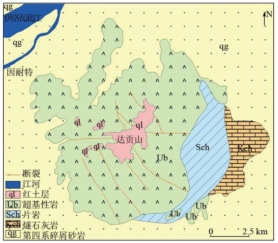
| [17] |
张道红, 孙媛. 缅甸达贡山含镍风化壳地质地球化学特征及成矿作用[J]. 桂林理工大学学报, 2010, 30(3):332-338.
|
| [17] |
Zhang D H, Sun Y. Geololgical-geochemistry characteristics and minerogenesis of nickel-bearing weathering crust in Taguang Taung,Myanmar[J]. Journal of Guilin University of Technology, 2010, 30(3):332-338.
|
| [18] |
潘瀚, 周守余, 李学彪, 等. 缅甸太公当地区那田塘镍铬多金属矿化探异常特征与找矿潜力[J]. 世界有色金属, 2018(8):118-120.
|
| [18] |
Pan H, Zhou S Y, Li X B, et al. The geochemical anomaly characteristics and prospecting potential of the Na ta Lin Taung nickel-chromium polymetallic mineral in Taguang Taung,Myanmar[J]. World Nonferrous Metals, 2018(8):118-120.
|
| [19] |
左黎阳. 缅甸达贡山红土型镍矿H区生产勘探、开发利用以及深部找矿研究[J]. 中国资源综合利用, 2020, 38(3):79-81.
|
| [19] |
Zuo L Y. Study on production exploration,development and utilization and deep prospecting in H district of Dagongshan nickel mine in Myanmar[J]. China Resources Comprehensive Utilization, 2020, 38(3):79-81.
|
| [20] |
程迁群, 罗太旭. 缅甸达贡山风化壳型硅酸镍矿床[J]. 云南地质, 2009, 28(4):420-424.
|
| [20] |
Cheng Q Q, Luo T X. Tagaung Taung Ni silicate deposit of weathering crust type,Myanmar[J]. Yunnan Geology, 2009, 28(4):420-424.
|
| [21] |
周守余, 杨明德, 颜自给, 等. 缅甸曼德勒省太公当矿区镍铬矿地质特征[J]. 矿床地质, 2014, 33(s1):1149-1150.
|
| [21] |
Zhou S Y, Yang M D, Yan Z J, et al. Geological characteristics of Tagaung Taung Nichrome Mine in Mandalay,Myanmar[J]. Mineral Deposits, 2014, 33(s1):1149-1150.
|
| [22] |
陈政融, 刘世增, 刘淑娟, 等. 基于Pleiades-1高分辨率卫星影像的干旱沙区遥感影像分类——以甘肃民勤青土湖为例[J]. 中国农学通报, 2015, 31(20):126-130.
doi: 10.11924/j.issn.1000-6850.casb15040132
|
| [22] |
Chen Z R, Liu S Z, Liu S J, et al. Classification of arid sand remote sensing image based on Pleiades-1 high resolution satellite image:A case study of Qingtu Lake in Minqin County of Gansu Province[J]. Chinese Agricultural Science Bulletin, 2015, 31(20):126-130.
|
| [23] |
柳明星, 刘建红, 马敏飞, 等. 基于GF-2 PMS影像和随机森林的甘肃临夏花椒树种植监测[J]. 自然资源遥感, 2022, 34(1):218-229.doi:10.6046/zrzyyg.2021112.
|
| [23] |
Liu M X, Liu J H, Ma M F, et al. Monitoring of Zanthoxylum bungeanum Maxim planting using GF-2 PMS images and the random forest algorithm:A case study of Linxia,Gansu Province[J]. Remote Sensing for Natural Resources, 2022, 34(1):218-229.doi:10.6046/zrzyyg.2021112.
|
| [24] |
Chen L, Qin Q M, Chen C, et al. Remote sensing information of mineralizing alteration extraction methods[C]// 2012 IEEE International Geoscience and Remote Sensing Symposium.Munich,Germany.IEEE, 2012:5947-5950.
|
| [25] |
Chen L, Qin Q M, Bai Y B, et al. Integrating remote sensing and super-low frequency electromagnetic technology in exploration of buried faults[C]// 2013 IEEE International Geoscience and Remote Sensing Symposium - IGARSS.Melbourne,VIC,Australia.IEEE, 2013:811-814.
|
| [26] |
Zhen G W, Chen L, Chen C, et al. Alteration anomaly information extraction using hyperspectral remote sensing in coalbed methane enrichment[C]// 2016 IEEE International Geoscience and Remote Sensing Symposium (IGARSS).Beijing,China.IEEE, 2016:5394-5397.
|
| [27] |
李靖霞, 文金花. 基于多尺度分割技术的高分辨率影像信息提取方法分析[J]. 防护林科技, 2021(1):42-45.
|
| [27] |
Li J X, Wen J H. Analysis of high-resolution image information extraction method based on multi-scale segmentation technology[J]. Protection Forest Science and Technology, 2021(1):42-45.
|
| [28] |
陈俊任, 周晓华, 卢兴. 基于分层次多尺度分割的面向对象地物分类方法[J]. 江西测绘, 2018(4):26-29.
|
| [28] |
Chen J R, Zhou X H, Lu X. Object-oriented classification method for surface features based on hierarchical and multi-scale segmentation[J]. Jiangxi Cehui, 2018(4):26-29.
|
| [29] |
苏腾飞. 基于边界信息的多尺度遥感影像分割质量非监督评价方法[J]. 自然资源遥感, 2023, 35(1):35-40.doi:10.6046/zrzyyg.2021444.
|
| [29] |
Su T F. A unsupervised quality valuation method for multi-scale remote sensing image segmentation based on boundary information[J]. Remote Sensing for Natural Resources, 2023, 35(1):35-40.doi:10.6046/zrzyyg.2021444.
|
| [30] |
刘小丹, 于宁, 邱红圆. 基于谱直方图的遥感图像分层次多尺度植被分割[J]. 国土资源遥感, 2017, 29(2):82-89.doi:10.6046/gtzyyg.2017.02.12.
|
| [30] |
Liu X D, Yu N, Qiu H Y. Hierarchical muti-scale vegetation segmentation of remote sensing image based on spectrum histogram[J]. Remote Sensing for Land and Resources, 2017, 29(2):82-89.doi:10.6046/gtzyyg.2017.02.12.
|
| [31] |
薛昱晟. 面向地理国情地表覆盖变化检测的多尺度分割方法研究[J]. 测绘与空间地理信息, 2021, 44(1):47-51.
|
| [31] |
Xue Y S. Multi-scale segmentation method regarding land cover change detection of national geographic conditions monitoring[J]. Geomatics & Spatial Information Technology, 2021, 44(1):47-51.
|
| [32] |
Chen L, Li W, Zhang X, et al. Application of object-oriented classification with hierarchical multi-scale segmentation for information extraction in nonoc nickel mine,the Philippines[C]// 2018 Fifth International Workshop on Earth Observation and Remote Sensing Applications (EORSA).Xi’an,China.IEEE, 2018:1-3.
|
|
Viewed |
|
|
|
Full text
|
|
|
|
|
Abstract
|
|
|
|
|
Cited |
|
|
|
|
| |
Shared |
|
|
|
|
| |
Discussed |
|
|
|
|
 2024,
Vol. 36
2024,
Vol. 36
 ), ZHANG Xian, LI Wei, LI Yu(