|
|
 |
|

|
|
|
Remote sensing information extraction for mangrove forests based on multi-feature parameters: A case study of Guangdong Province |
WANG Yumiao1,2( ), LI Sheng1,3, DONG Chunyu2, YANG Gang2() ), LI Sheng1,3, DONG Chunyu2, YANG Gang2() |
1. Key Laboratory of Urban Land Resources Monitoring and Simulation, Ministry of Natural Resources, Shenzhen 518000, China
2. Department of Geography and Spatial Information Techniques, Ningbo University, Ningbo 315211, China
3. Shenzhen Data Management Center of Planning and Natural Resource, Shenzhen 518000, China |
|
|
|
|
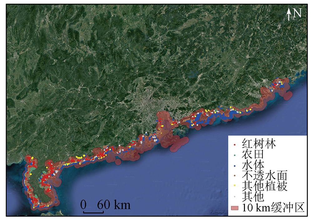
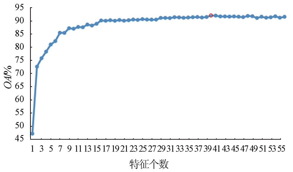
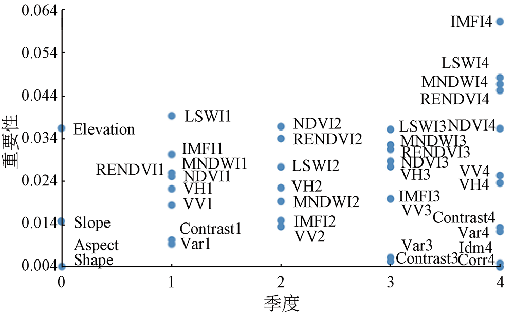
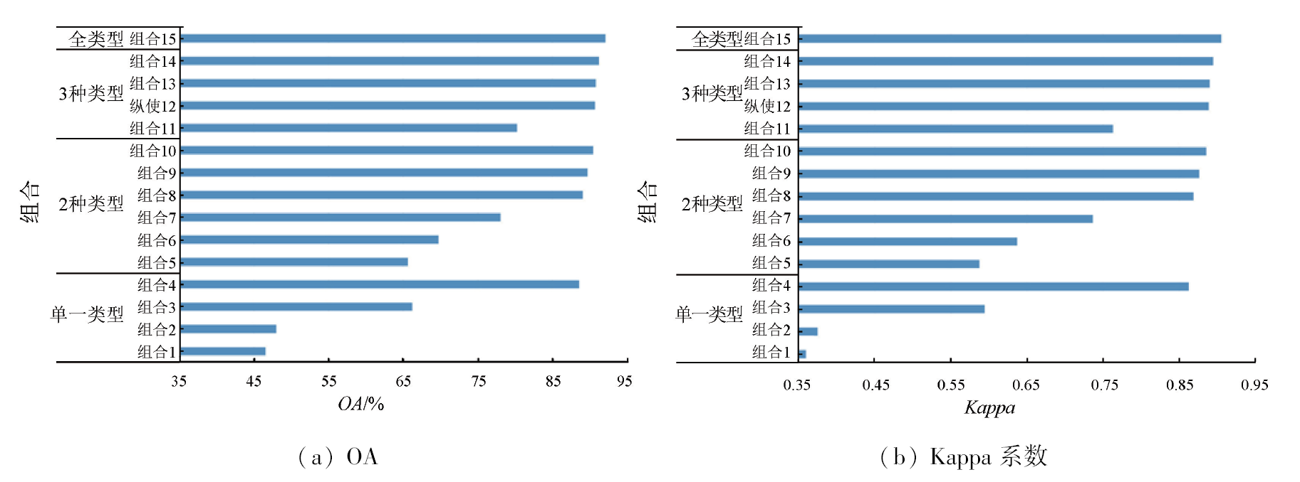
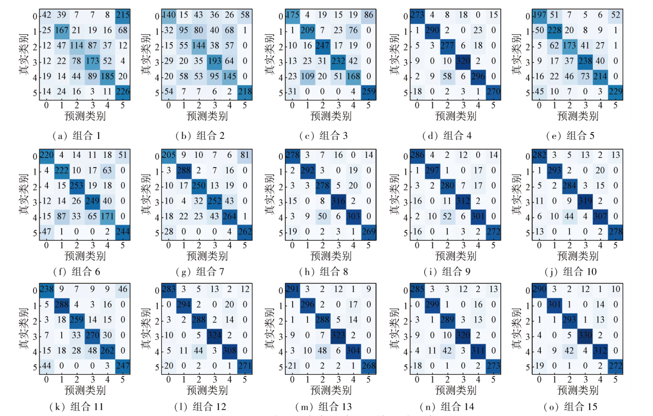
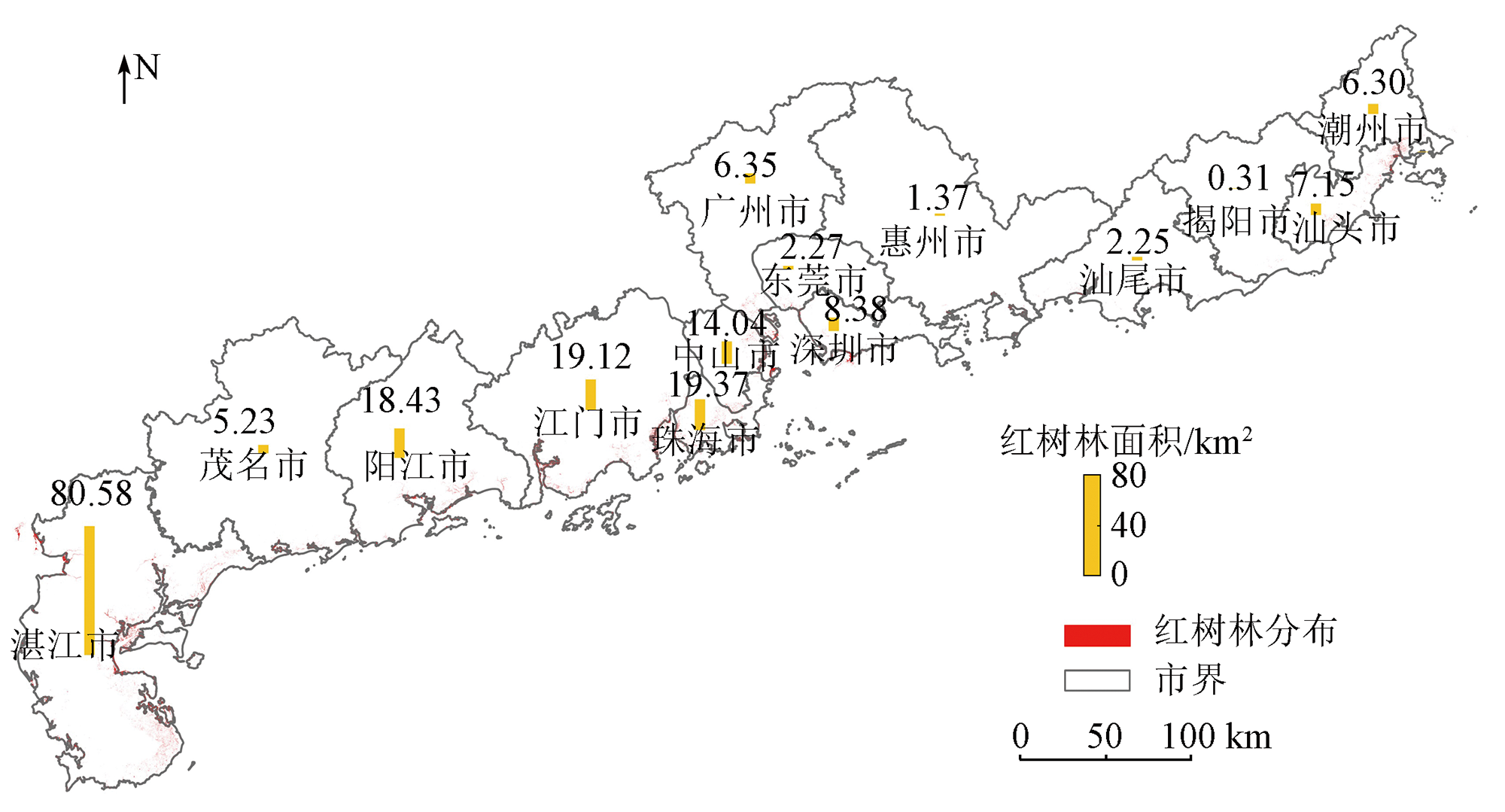
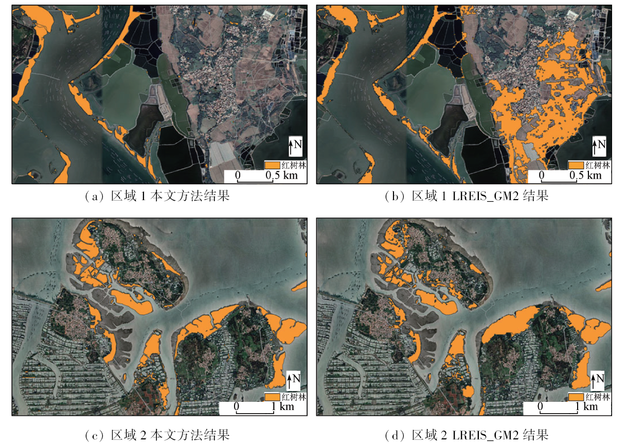
Abstract Accurate mangrove forest distribution information is critical to the conservation and management of mangrove forests. Despite extensive studies on the remote sensing mapping of mangrove forests, it is necessary to improve their mapping accuracy by effectively utilizing multi-source remote sensing features. First, this study designed 15 feature associations using temporal features, including spectral, scattering, texture, and terrain features, which were extracted from multi-source remote sensing data. Then, using a random forest model, it analyzed the accuracy of different feature associations in mangrove forest identification, obtaining the optimal feature association. Finally, this study mapped the 10-m-resolution mangrove forest distribution of Guangdong Province in 2021 based on platform Google Earth Engine (GEE). The results show that spectral features in winter exhibited the highest importance, with richer feature types corresponding to higher mapping accuracy. The optimal feature association yielded overall accuracy of 92.25% and a Kappa value of 0.91. Overall, this study extracted information on mangrove forests in Guangdong based on multi-feature parameters and the optimal feature association. The results of this study will provide a scientific reference for accurate mapping of mangrove forests on a large scale.
|
| Keywords
information extraction of mangrove forests
multi-source remote sensing data
GEE
machine learning
Guangdong Province
|
|
|
|
Issue Date: 13 March 2024
|
|
|
| [1] |
Pastor-Guzman J, Dash J, Atkinson P M. Remote sensing of mangrove forest phenology and its environmental drivers[J]. Remote Sensing of Environment, 2018, 205:71-84.
doi: 10.1016/j.rse.2017.11.009
url: https://linkinghub.elsevier.com/retrieve/pii/S0034425717305333
|
| [2] |
何斌源, 范航清, 王瑁, 等. 中国红树林湿地物种多样性及其形成[J]. 生态学报, 2007, 27(11): 4859-4870.
|
| [2] |
He B Y, Fan H Q, Wang M, et al. Species diversity in mangrove wetlands of China and its causation analyses[J]. Acta Ecologica Sinic, 2007, 27(11): 4859-4870.
|
| [3] |
章恒, 王世新, 周艺, 等. 多源遥感影像红树林信息提取方法比较[J]. 湿地科学, 2015, 13(2):145-152.
|
| [3] |
Zhang H, Wang S X, Zhou Y, et al. Comparison of different metho-ds of mangrove extraction from multi-source remote sensing images[J]. Wetland Science, 2015, 13(2):145-152.
|
| [4] |
麦少芝, 徐颂军. 广东红树林资源的保护与开发[J]. 海洋开发与管理, 2005, 22(1):44-48.
|
| [4] |
Mai S Z, Xu S J. Protection and development of mangrove resources in Guangdong Province[J]. Ocean Development and Management, 2005, 22(1):44-48.
|
| [5] |
Giri C. Observation and monitoring of mangrove forests using remote sensing:Opportunities and challenges[J]. Remote Sensing, 2016, 8(9):783.
doi: 10.3390/rs8090783
url: http://www.mdpi.com/2072-4292/8/9/783
|
| [6] |
Kirui K B, Kairo J G, Bosire J, et al. Mapping of mangrove forest land cover change along the Kenya coastline using Landsat imagery[J]. Ocean and Coastal Management, 2013, 83:19-24.
doi: 10.1016/j.ocecoaman.2011.12.004
url: https://linkinghub.elsevier.com/retrieve/pii/S0964569111001943
|
| [7] |
Warfield A D, Leon J X. Estimating mangrove forest volume using terrestrial laser scanning and UAV-derived structure-from-motion[J]. Drones, 2019, 3(2):32.
doi: 10.3390/drones3020032
url: https://www.mdpi.com/2504-446X/3/2/32
|
| [8] |
徐逸, 甄佳宁, 蒋侠朋, 等. 无人机遥感与XGBoost的红树林物种分类[J]. 遥感学报, 2021, 25(3):737-752.
|
| [8] |
Xu Y, Zhen J N, Jiang X P, et al. Mangrove species classification with UAV-based remote sensing data and XGBoost[J]. National Remote Sensing Bulletin, 2021, 25(3):737-752.
doi: 10.11834/jrs.20210281
url: http://www.ygxb.ac.cn/zh/article/doi/10.11834/jrs.20210281/
|
| [9] |
王子予, 刘凯, 彭力恒, 等. 基于Google Earth Engine的1986—2018 年广东红树林年际变化遥感分析[J]. 热带地理, 2020, 40(5):881-892.
doi: 10.13284/j.cnki.rddl.003268
|
| [9] |
Wang Z Y, Liu K, Peng L H, et al. Analysis of mangrove annual changes in Guangdong Province during 1986—2018 based on Google Earth Engine[J]. Tropical Geography, 2020, 40(5):881-892.
|
| [10] |
Jia M, Wang Z, Wang C, et al. A new vegetation index to detect periodically submerged mangrove forest using single-tide Sentinel-2 imagery[J]. Remote Sensing, 2019, 11(17):2043.
doi: 10.3390/rs11172043
url: https://www.mdpi.com/2072-4292/11/17/2043
|
| [11] |
Jia M, Wang Z, Li L, et al. Mapping China’s mangroves based on an object-oriented classification of Landsat imagery[J]. Wetlands, 2014, 34(2):277-283.
doi: 10.1007/s13157-013-0449-2
url: https://link.springer.com/10.1007/s13157-013-0449-2
|
| [12] |
Ma C, Ai B, Zhao J, et al. Change detection of mangrove forests in coastal Guangdong during the past three decades based on remote sensing data[J]. Remote Sensing, 2019, 11(8):921.
doi: 10.3390/rs11080921
url: https://www.mdpi.com/2072-4292/11/8/921
|
| [13] |
Xiao H, Su F Z, Fu D J, et al. 10-m global mangrove classification products of 2018—2020[DS/OL]. Science Data Bank, 2021[2022-12-09].http://doi.org/10.11922/sciencedb.01019.
url: http://doi.org/10.11922/sciencedb.01019
|
| [14] |
邓静雯, 田义超, 张强, 等. 机载LiDAR在红树林林分平均高估算中的应用[J]. 自然资源遥感, 2022, 34(3):129-137.doi: 10.6046/zrzyyg.2021237.
|
| [14] |
Deng J W, Tian Y C, Zhang Q, et al. Application of airborne LiDAR in the estimation of the mean height of mangrove stand[J]. Remote Sensing for Natural Resources, 2022, 34(3):129-137.doi: 10.6046/zrzyyg.2021237.
|
| [15] |
Gorelick N, Hancher M, Dixon M, et al. Google Earth Engine:Planetary-scale geospatial analysis for everyone[J]. Remote Sensing of Environment, 2017, 202:18-27.
doi: 10.1016/j.rse.2017.06.031
url: https://linkinghub.elsevier.com/retrieve/pii/S0034425717302900
|
| [16] |
Zhao C, Qin C Z. 10-m-resolution mangrove maps of China derived from multi-source and multi-temporal satellite observations[J]. ISPRS Journal of Photogrammetry and Remote Sensing, 2020, 169:389-405.
doi: 10.1016/j.isprsjprs.2020.10.001
url: https://linkinghub.elsevier.com/retrieve/pii/S0924271620302732
|
| [17] |
Peng Y, Zheng M, Zheng Z, et al. Virtual increase or latent loss? A reassessment of mangrove populations and their conservation in Guangdong,southern China[J]. Marine Pollution Bulletin, 2016, 109(2):691-699.
doi: 10.1016/j.marpolbul.2016.06.083
url: https://linkinghub.elsevier.com/retrieve/pii/S0025326X16304878
|
| [18] |
吴培强, 马毅, 李晓敏, 等. 广东省红树林资源变化遥感监测[J]. 海洋学研究, 2011, 29(4):16-24.
|
| [18] |
Wu P Q, Ma Y, Li X M, et al. Remote sensing monitoring of the mangrove forests resources of Guangdong Province[J]. Journal of Marine Sciences, 2011, 29(4):16-24.
|
| [19] |
江娜, 陈超, 韩海丰. 海岸带地类统计模型中DEM空间尺度优选方法[J]. 自然资源遥感, 2022, 34(1):34-42.doi: 10.6046/zrzyyg.2022005.
|
| [19] |
Jiang N, Chen C, Han H F. An optimization method of DEM resolution for land type statistical model of coastal zones[J]. Remote Sensing for Natural Resources, 2022, 34(1):34-42.doi: 10.6046/zrzyyg.2022005.
|
| [20] |
Farr T G, Rosen P A, Caro E, et al. The shuttle Radar topography mission[J]. Reviews of Geophysics, 2007, 45(2):361.
|
| [21] |
Tucker C J. Red and photographic infrared linear combinations for monitoring vegetation[J]. Remote Sensing of Environment, 1979, 8(2):127-150.
doi: 10.1016/0034-4257(79)90013-0
url: https://linkinghub.elsevier.com/retrieve/pii/0034425779900130
|
| [22] |
Xiao X, Boles S, Liu J, et al. Mapping paddy rice agriculture in southern China using multi-temporal MODIS images[J]. Remote Sensing of Environment, 2005, 95(4):480-492.
doi: 10.1016/j.rse.2004.12.009
url: https://linkinghub.elsevier.com/retrieve/pii/S0034425705000209
|
| [23] |
Xu H. Modification of normalised difference water index (NDWI) to enhance open water features in remotely sensed imagery[J]. International Journal of Remote Sensing, 2006, 27(14):3025-3033.
doi: 10.1080/01431160600589179
url: https://www.tandfonline.com/doi/full/10.1080/01431160600589179
|
| [24] |
贾明明. 1973—2013年中国红树林动态变化遥感分析[D]. 长春: 中国科学院东北地理与农业生态研究所, 2014.
|
| [24] |
Jia M M. Remote sensing analysis of China’s mangrove forests dynamics during 1973 to 2013[D]. Changchun: Northeast Institute of Geography and Agroecology,Chinese Academy of Sciences, 2014.
|
| [25] |
Lin S, Li J, Liu Q, et al. Evaluating the effectiveness of using vegetation indices based on red-edge reflectance from Sentinel-2 to estimate gross primary productivity[J]. Remote Sensing, 2019, 11(11):1303.
doi: 10.3390/rs11111303
url: https://www.mdpi.com/2072-4292/11/11/1303
|
| [26] |
何昭欣, 张淼, 吴炳方, 等. Google Earth Engine支持下的江苏省夏收作物遥感提取[J]. 地球信息科学学报, 2019, 21(5):752-766.
doi: 10.12082/dqxxkx.2019.180420
|
| [26] |
He Z X, Zhang M, Wu B F, et al. Extraction of summer crop in Jiangsu based on Google Earth Engine[J]. Journal of Geo-Information Science, 2019, 21(5):752-766.
|
| [27] |
Naboureh A, Li A, Bian J, et al. A hybrid data balancing method for classification of imbalanced training data within Google Earth Engine:Case studies from mountainous regions[J]. Remote Sensing, 2020, 12(20):3301.
doi: 10.3390/rs12203301
url: https://www.mdpi.com/2072-4292/12/20/3301
|
| [28] |
Ghorbanian A, Kakooei M, Amani M, et al. Improved land cover map of Iran using Sentinel imagery within Google Earth Engine and a novel automatic workflow for land cover classification using migrated training samples[J]. ISPRS Journal of Photogrammetry and Remote Sensing, 2020, 167:276-288.
doi: 10.1016/j.isprsjprs.2020.07.013
url: https://linkinghub.elsevier.com/retrieve/pii/S0924271620302008
|
| [29] |
Song Q, Hu Q, Zhou Q B, et al. In-season crop mapping with GF-1/WFV data by combining object-based image analysis and random forest[J]. Remote Sensing, 2017, 9(11):1184.
doi: 10.3390/rs9111184
url: http://www.mdpi.com/2072-4292/9/11/1184
|
| [30] |
Van Beijma S, Comber A, Lamb A. Random forest classification of salt marsh vegetation habitats using quad-polarimetric airborne SAR,elevation and optical RS data[J]. Remote Sensing of Environment, 2014, 149:118-129.
doi: 10.1016/j.rse.2014.04.010
url: https://linkinghub.elsevier.com/retrieve/pii/S0034425714001485
|
|
Viewed |
|
|
|
Full text
|
|
|
|
|
Abstract
|
|
|
|
|
Cited |
|
|
|
|
| |
Shared |
|
|
|
|
| |
Discussed |
|
|
|
|
 2024,
Vol. 36
2024,
Vol. 36