|
|
 |
|

|
|
|
A MobileNet-based lightweight cloud detection model |
YE Wujian1( ), XIE Linfeng2, LIU Yijun1, WEN Xiaozhuo1, Li Yang1 ), XIE Linfeng2, LIU Yijun1, WEN Xiaozhuo1, Li Yang1 |
1. School of Integrated Circuits, Guangdong University of Technology, Guangzhou 510006, China
2. School of Information Engineering, Guangdong University of Technology, Guangzhou 510006, China |
|
|
|
|
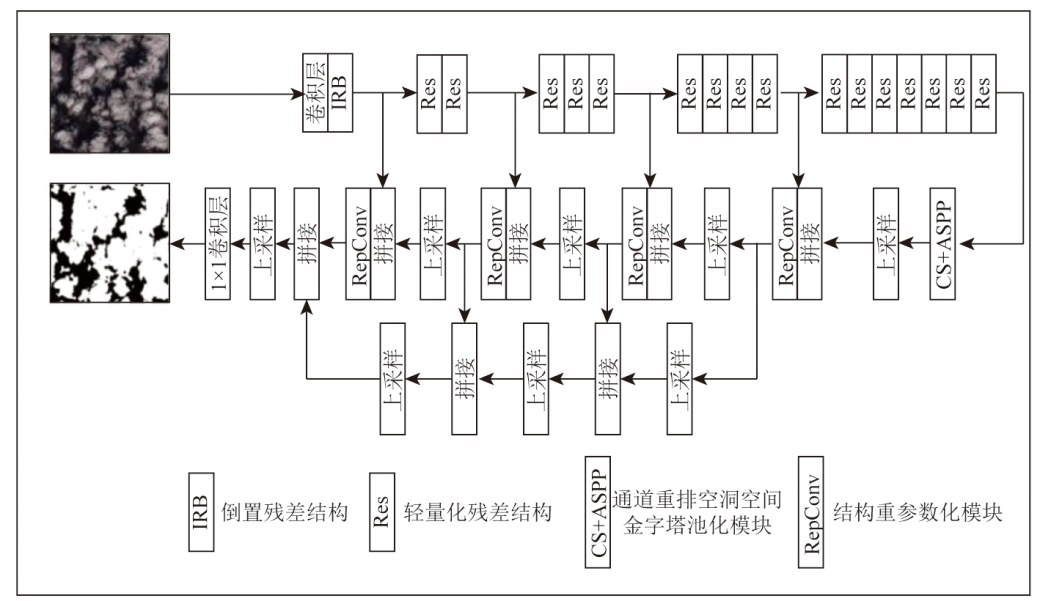
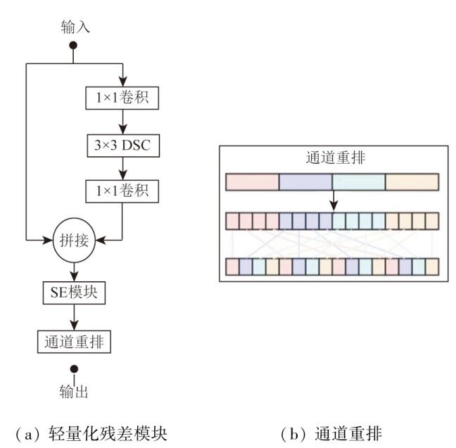
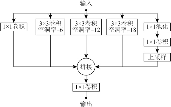
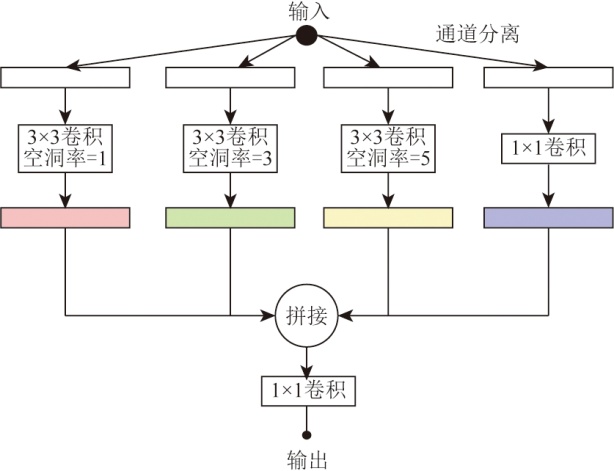
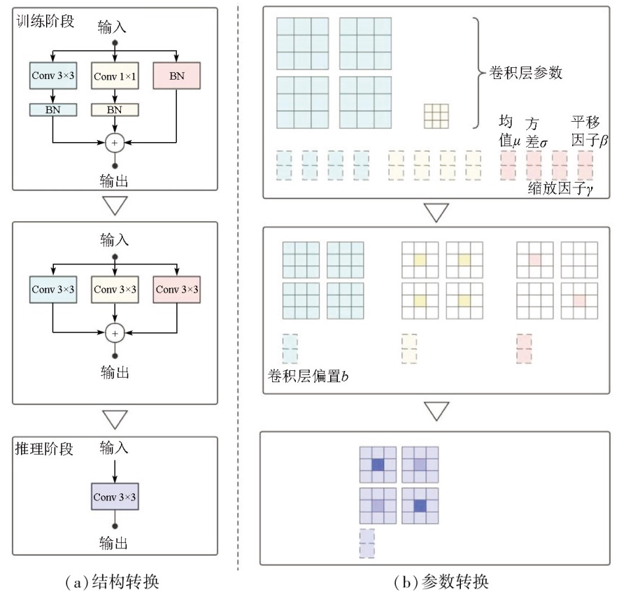
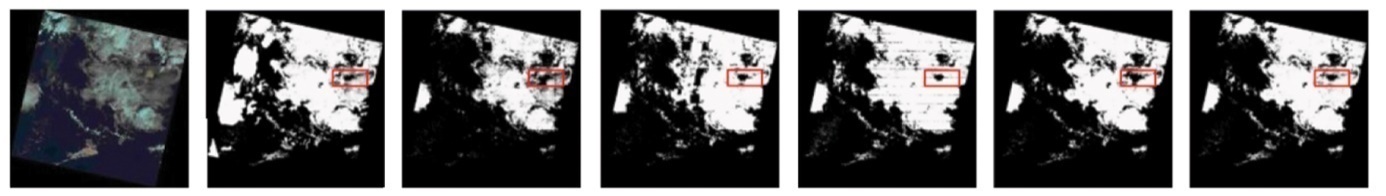
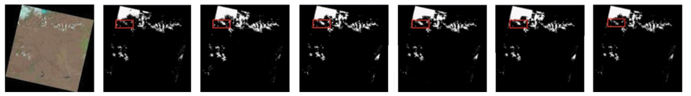
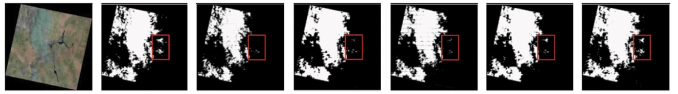
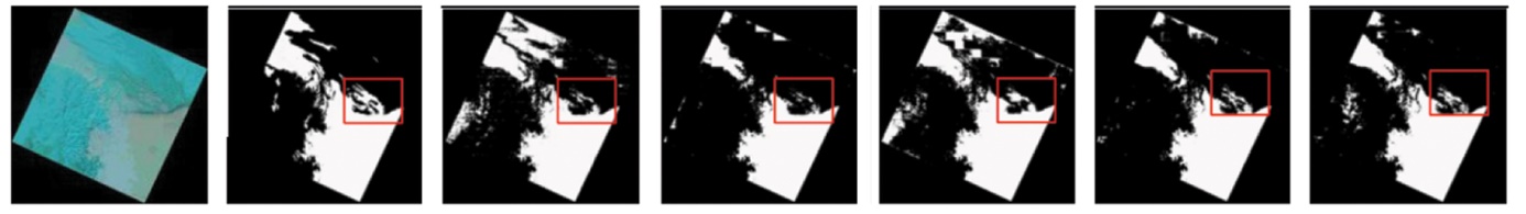
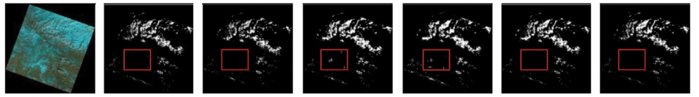
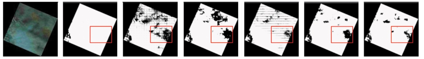
Abstract The high computational complexity and large model scales of existing cloud detection algorithms render their deployment on edge devices almost infeasible. To address this challenge, this study proposed a MobileNet-based lightweight cloud detection model. In the downsampling stage, a residual module based on the attention mechanism was employed to reduce model parameters through group convolution. The channel shuffling mechanism and the squeeze-and-excitation (SE) channel attention were integrated to enhance the information exchange between channels. These approaches reduced parameters and computational complexity while maintaining the ability to extract significant features. In the upsampling stage, the RepConv module and the improved atrous spatial pyramid pooling (ASPP) module were used to enhance the network’s learning capability and its ability to capture image details and spatial information. Experimental results demonstrate that the proposed model can achieve higher cloud detection accuracy while reducing parameters and model complexity, substantiating its practicality and feasibility.
|
| Keywords
cloud detection
MobileNet
attention mechanism
multi-scale feature
atrous spatial pyramid pooling (ASPP) module
|
|
|
|
Issue Date: 01 July 2025
|
|
|
| [1] |
Lu C L, Bai Z G.Characteristics and typical applications of GF-1 satellite[C]// 2015 IEEE International Geoscience and Remote Sensing Symposium (IGARSS).IEEE, 2015:1246-1249.
|
| [2] |
Xu X, Shi Z W, Pan B. ℓ0-based sparse hyperspectral unmixing using spectral information and a multi-objectives formulation[J]. ISPRS Journal of Photogrammetry and Remote Sensing, 2018,141:46-58.
|
| [3] |
Wei J, Huang W, Li Z Q, et al. Estimating 1-km-resolution PM2.5 concentrations across China using the space-time random forest approach[J]. Remote Sensing of Environment, 2019,231:111221.
|
| [4] |
Wang Z G, Kang Q, Xun Y J, et al. Military reconnaissance application of high-resolution optical satellite remote sensing[C]// International Symposium on Optoelectronic Technology and Application 2014:Optical Remote Sensing Technology and Applications.SPIE, 2014,9299:301-305.
|
| [5] |
Magney T S, Vierling L A, Eitel J U H. et al. Response of high frequency Photochemical Reflectance Index (PRI) measurements to environmental conditions in wheat[J]. Remote Sensing of Environment, 2016,173:84-97.
|
| [6] |
Zhang Y C, Rossow W B, Lacis A A, et al. Calculation of radiative fluxes from the surface to top of atmosphere based on ISCCP and other global data sets:Refinements of the radiative transfer model and the input data[J]. Journal of Geophysical Research:Atmospheres, 2004,109:D19105.
|
| [7] |
邓丁柱. 基于深度学习的多源卫星遥感影像云检测方法[J]. 自然资源遥感, 2023, 35(4):9-16.doi:10.6046/zrzyyg.2022317.
|
| [7] |
Deng D Z. Deep learning-based cloud detection method for multi-source satellite remote sensing images[J]. Remote Sensing for Na-tural Resources, 2023, 35(4):9-16.doi:10.6046/zrzyyg.2022317.
|
| [8] |
刘紫涵, 吴艳兰. 遥感图像云检测方法研究进展[J]. 国土资源遥感, 2017, 29(4):6-12.doi:10.6046/gtzyyg.2017.04.02.
|
| [8] |
Liu Z H, Wu Y L. A review of cloud detection methods in remote sensing images[J]. Remote Sensing for Land and Resources, 2017, 29(4):6-12.doi:10.6046/gtzyyg.2017.04.02.
|
| [9] |
刘小波, 刘鹏, 蔡之华, 等. 基于深度学习的光学遥感图像目标检测研究进展[J]. 自动化学报, 2021, 47(9):2078-2089.
|
| [9] |
Liu X B, Liu P, Cai Z H, et al. Research progress of optical remote sensing image object detection based on deep learning[J]. ActaAutomatica Sinica, 2021, 47(9):2078-2089.
|
| [10] |
He Q B, Sun X, Yan Z Y, et al. DABNet:Deformable contextual and boundary-weighted network for cloud detection in remote sen-sing images[J]. IEEE Transactions on Geoscience and Remote Sensing, 2021,60:5601216.
|
| [11] |
Wu X, Shi Z W. Scene aggregation network for cloud detection on remote sensing imagery[J]. IEEE Geoscience and Remote Sensing Letters, 2022,19:1000505.
|
| [12] |
刘广进, 王光辉, 毕卫华, 等. 基于DenseNet与注意力机制的遥感影像云检测算法[J]. 自然资源遥感, 2022, 34(2):88-96.doi:10.6046/zrzyyg.2021128.
|
| [12] |
Liu G J, Wang G H, Bi W H, et al. Cloud detection algorithm of remote sensing image based on DenseNet and attention mechanism[J]. Remote Sensing for Natural Resources, 2022, 34(2):88-96.doi:10.6046/zrzyyg.2021128.
|
| [13] |
孙盛, 蒙芝敏, 胡忠文, 等. 多尺度轻量化CNN在SAR图像地物分类中的应用[J]. 自然资源遥感, 2023, 35(1):27-34.doi: 10.6046/zrzyyg.2021421.
|
| [13] |
Sun S, Meng Z M, Hu Z W, et al. Application of multi-scale and lightweight CNN in SAR image-based surface feature classification[J]. Remote Sensing for Natural Resources, 2023, 35(1):27-34.doi: 10.6046/zrzyyg.2021421.
|
| [14] |
Yin Y F, Cheng X, Shi F, et al. High-order spatial interactions enhanced lightweight model for optical remote sensing image-based small ship detection[J]. IEEE Transactions on Geoscience and Remote Sensing, 2024,62:4201416.
|
| [15] |
Howard A G, Zhu M L, Chen B, et al. MobileNets:Efficient convolutional neural networks for mobile vision applications[J/OL]. arXiv, 2017(2017-04-17). https://arxiv.org/abs/1704.04861.
url: https://arxiv.org/abs/1704.04861
|
| [16] |
Sandler M, Howard A, Zhu M L, et al. MobileNetV2:Inverted residuals and linear bottlenecks[C]// 2018 IEEE/CVF Conference on Computer Vision and Pattern Recognition. IEEE, 2018:4510-4520.
|
| [17] |
Chen L C, Papandreou G, Schroff F, et al. Rethinkingatrous convolution for semantic image segmentation[J/OL]. arXiv, 2017(2017-06-17). https://arxiv.org/abs/1706.05587.
url: https://arxiv.org/abs/1706.05587
|
| [18] |
Ding X H, Zhang X Y, Ma N N, et al. RepVGG:Making VGG-style ConvNets great again[C]// 2021 IEEE/CVF Conference on Computer Vision and Pattern Recognition (CVPR).IEEE, 2021:13728-13737.
|
| [19] |
Mohajerani S, Saeedi P. Cloud-net:An end-to-end cloud detection algorithm for Landsat8 imagery[C]// IGARSS 2019 - 2019 IEEE International Geoscience and Remote Sensing Symposium.IEEE, 2019:1029-1032.
|
| [20] |
Zhao H S, Qi X J, Shen X Y, et al. ICNet for real-time semantic segmentation on high-resolution images[J/OL]. arXiv, 2017(2017-04-27). http://arxiv.org/abs/1704.08545v2.
url: http://arxiv.org/abs/1704.08545v2
|
| [21] |
Li H C, Xiong P F, Fan H Q, et al.DFANet:Deep feature aggregation for real-time semantic segmentation[C]// 2019 IEEE/CVF Conference on Computer Vision and Pattern Recognition (CVPR).IEEE, 2019:9514-9523.
|
| [22] |
Wang Y, Zhou Q, Liu J, et al. Lednet:A lightweight encoder-decoder network for real-time semantic segmentation[C]// 2019 IEEE International Conference on Image Processing (ICIP).IEEE, 2019:1860-1864.
|
|
Viewed |
|
|
|
Full text
|
|
|
|
|
Abstract
|
|
|
|
|
Cited |
|
|
|
|
| |
Shared |
|
|
|
|
| |
Discussed |
|
|
|
|
 2025,
Vol. 37
2025,
Vol. 37