|
|
|
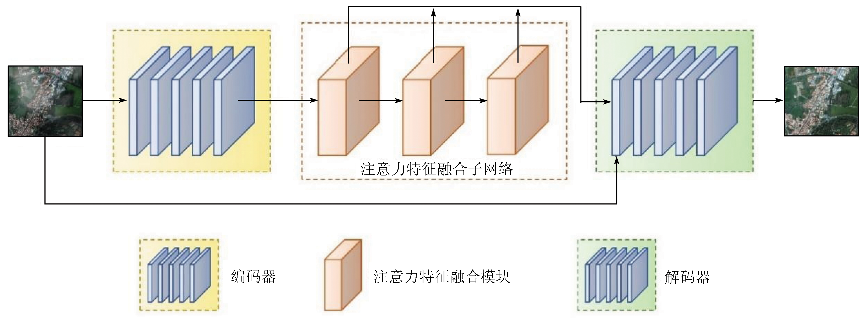
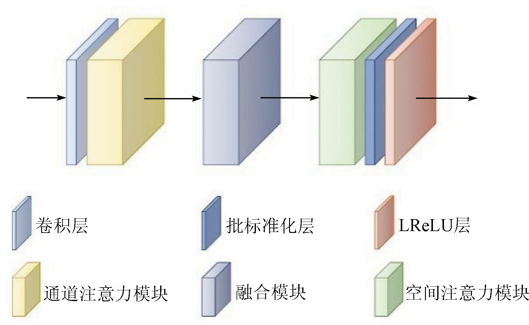
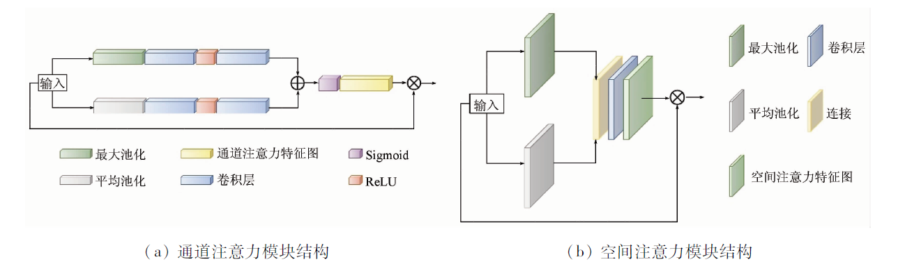
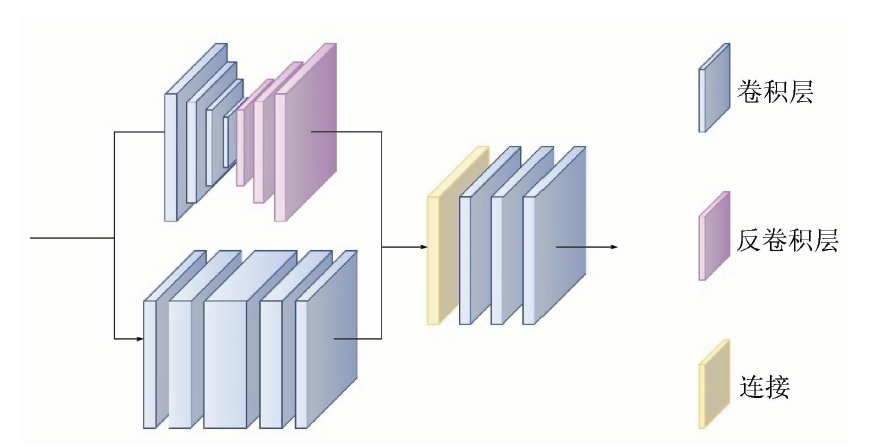
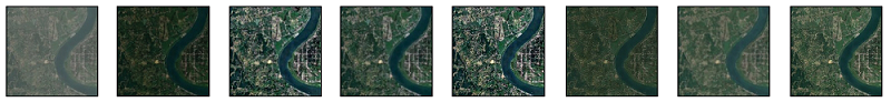
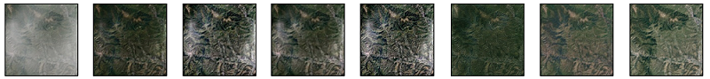
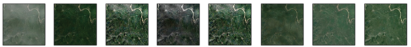
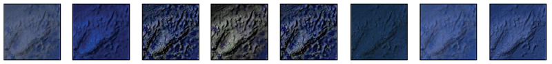
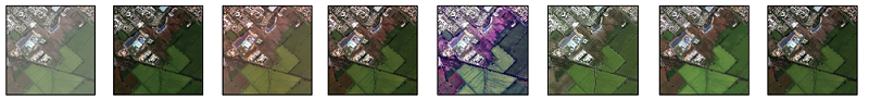
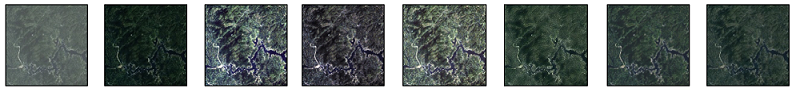
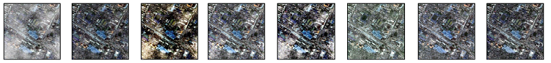
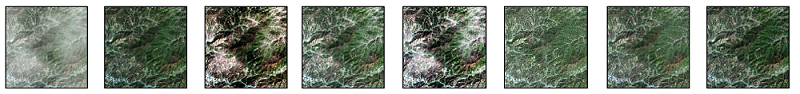
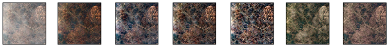
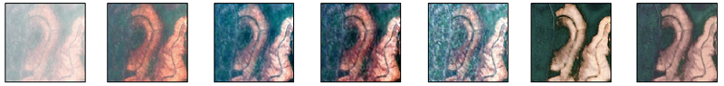
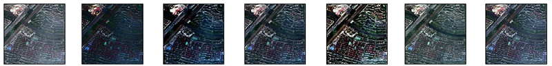
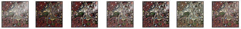
Abstract The thin cloud removal from remote sensing images with uneven thin cloud cover suffers from undercorrection or color distortion. This study proposed a high-fidelity end-to-end network method for thin cloud removal based on attentional feature fusion. First, this study designed an attentional feature fusion module integrating the attention mechanism and a fusion module. Through the cascade of three attentional feature fusion modules, the network focused on extracting the information on thin-cloud cover areas, reducing the impact of cloud-free areas. Furthermore, this study improved the color fidelity and detail clarity of images using the color and sharpening loss functions. The experimental results show that this method outperformed other methods in visual and quantitative evaluation indices (peak signal-to-noise ratio and structural similarity). This method yielded satisfactory effects of cloud removal in images with uneven thin cloud cover in various scenarios, producing images with actual colors, smooth brightness transition, and distinct detail contours.
|
| Keywords
thin cloud removal
attention mechanism
feature fusion
remote sensing image
deep learning
|
|
|
|
Issue Date: 19 September 2023
|
|
|
| [1] |
He K, Sun J, Tang X. Single image haze removal using dark channel prior[J]. IEEE Transactions on Pattern Analysis and Machine Intelligence, 2010, 33(12):2341-2353.
doi: 10.1109/TPAMI.2010.168
url: http://ieeexplore.ieee.org/document/5567108/
|
| [2] |
Narasimhan S G, Nayar S K. Contrast restoration of weather degraded images[J]. IEEE Transactions on Pattern Analysis and Machine Intelligence, 2003, 25(6):713-724.
doi: 10.1109/TPAMI.2003.1201821
url: http://ieeexplore.ieee.org/document/1201821/
|
| [3] |
Li J, Hu Q, Ai M. Haze and thin cloud removal via sphere model improved dark channel prior[J]. IEEE Geoscience and Remote Sensing Letters, 2018, 16(3):472-476.
doi: 10.1109/LGRS.2018.2874084
url: https://ieeexplore.ieee.org/document/8500152/
|
| [4] |
Shi S, Zhang Y, Zhou X, et al. A novel thin cloud removal method based on multiscale dark channel prior (MDCP)[J]. IEEE Geoscience and Remote Sensing Letters, 2021, 19:1-5.
|
| [5] |
Li Y, Ren J, Huang Y. An end-to-end system for unmanned aerial vehicle high-resolution remote sensing image haze removal algorithm using convolution neural network[J]. IEEE Access, 2020, 8:158787-158797.
doi: 10.1109/Access.6287639
url: https://ieeexplore.ieee.org/xpl/RecentIssue.jsp?punumber=6287639
|
| [6] |
Pan H. Cloud removal for remote sensing imagery via spatial attention generative adversarial network[J/OL]. arXiv, 2020(2020-11-14). https://arxiv.org/abs/2009.13015.
url: https://arxiv.org/abs/2009.13015
|
| [7] |
Li J, Wu Z, Hu Z, et al. Thin cloud removal in optical remote sensing images based on generative adversarial networks and physical model of cloud distortion[J]. ISPRS Journal of Photogrammetry and Remote Sensing, 2020, 166:373-389.
doi: 10.1016/j.isprsjprs.2020.06.021
url: https://linkinghub.elsevier.com/retrieve/pii/S0924271620301787
|
| [8] |
Zi Y, Xie F, Zhang N, et al. Thin cloud removal for multispectral remote sensing images using convolutional neural networks combined with an imaging model[J]. IEEE Journal of Selected Topics in Applied Earth Observations and Remote Sensing, 2021, 14:3811-3823.
doi: 10.1109/JSTARS.2021.3068166
url: https://ieeexplore.ieee.org/document/9384224/
|
| [9] |
Luo X, Rong W, Zhou J. A spatial-spectral adaptive thin-cloud removal method based on slow feature analysis[J]. Remote Sensing Letters, 2022, 13(8):747-755.
doi: 10.1080/2150704X.2022.2079387
url: https://www.tandfonline.com/doi/full/10.1080/2150704X.2022.2079387
|
| [10] |
Woo S, Park J, Lee J Y, et al. Cbam:Convolutional block attention module[C]// Proceedings of the European Conference on Computer Vision (ECCV). 2018:3-19.
|
| [11] |
张焕, 张庆, 于纪言. 激活函数的发展综述及其性质分析[J]. 西华大学学报(自然科学版), 2021, 40(4):1-10.
|
| [11] |
Zhang H, Zhang Q, Yu J Y. Overview of the development of activation function and its nature analysis[J]. Journal of Xihua University (Natural Science Edition), 2021, 40(4):1-10.
|
| [12] |
Gupta D, Hazarika B B, Berlin M. Robust regularized extreme learning machine with asymmetric Huber loss function[J]. Neural Computing and Applications, 2020, 32(16):12971-12998.
doi: 10.1007/s00521-020-04741-w
|
| [13] |
Pang B, Nijkamp E, Wu Y N. Deep learning with tensorflow:A review[J]. Journal of Educational and Behavioral Statistics, 2020, 45(2):227-248.
doi: 10.3102/1076998619872761
|
| [14] |
Lin D, Xu G, Wang X, et al. A remote sensing image dataset for cloud removal[J/OL]. arXiv, 2019(2019-01-03). http://arxiv.org/abs/1901.00600v1.
url: http://arxiv.org/abs/1901.00600v1
|
| [15] |
Pan X, Xie F, Jiang Z, et al. No-reference assessment on haze for remote-sensing images[J]. IEEE Geoscience and Remote Sensing Letters, 2016, 13(12):1855-1859.
doi: 10.1109/LGRS.2016.2614890
url: http://ieeexplore.ieee.org/document/7600445/
|
| [16] |
Ma Y. The mathematic magic of Photoshop blend modes for image processing[C]// 2011 International Conference on Multimedia Technology.IEEE, 2011:5159-5161.
|
| [17] |
Ren W, Pan J, Zhang H, et al. Single image dehazing via multi-scale convolutional neural networks with holistic edges[J]. International Journal of Computer Vision, 2020, 128(1):240-259.
doi: 10.1007/s11263-019-01235-8
|
| [18] |
Dhara S K, Roy M, Sen D, et al. Color cast dependent image dehazing via adaptive airlight refinement and non-linear color balancing[J]. IEEE Transactions on Circuits and Systems for Video Technology, 2020, 31(5):2076-2081.
doi: 10.1109/TCSVT.2020.3007850
url: https://ieeexplore.ieee.org/document/9134933/
|
| [19] |
Cho Y, Jeong J, Kim A. Model-assisted multiband fusion for single image enhancement and applications to robot vision[J]. IEEE Robotics and Automation Letters, 2018, 3(4):2822-2829.
doi: 10.1109/ROBOT.1996.506590
url: http://ieeexplore.ieee.org/document/506590/
|
| [20] |
蒋刚毅, 黄大江, 王旭, 等. 图像质量评价方法研究进展[J]. 电子与信息学报, 2010, 32(1):219-226.
|
| [20] |
Jiang G Y, Huang D J, Wang X, et al. Overview on image quality assessment methods[J]. Journal of Electronics and Information Technology, 2010, 32(1):219-226.
|
| [21] |
Mittal A, Moorthy A K, Bovik A C. No-reference image quality assessment in the spatial domain[J]. IEEE Transactions on Image Processing, 2012, 21(12):4695-4708.
doi: 10.1109/TIP.2012.2214050
pmid: 22910118
|
|
Viewed |
|
|
|
Full text
|
|
|
|
|
Abstract
|
|
|
|
|
Cited |
|
|
|
|
| |
Shared |
|
|
|
|
| |
Discussed |
|
|
|
|
 2023,
Vol. 35
2023,
Vol. 35
 ), HUANG Wei(